
Tree-lined perimeter
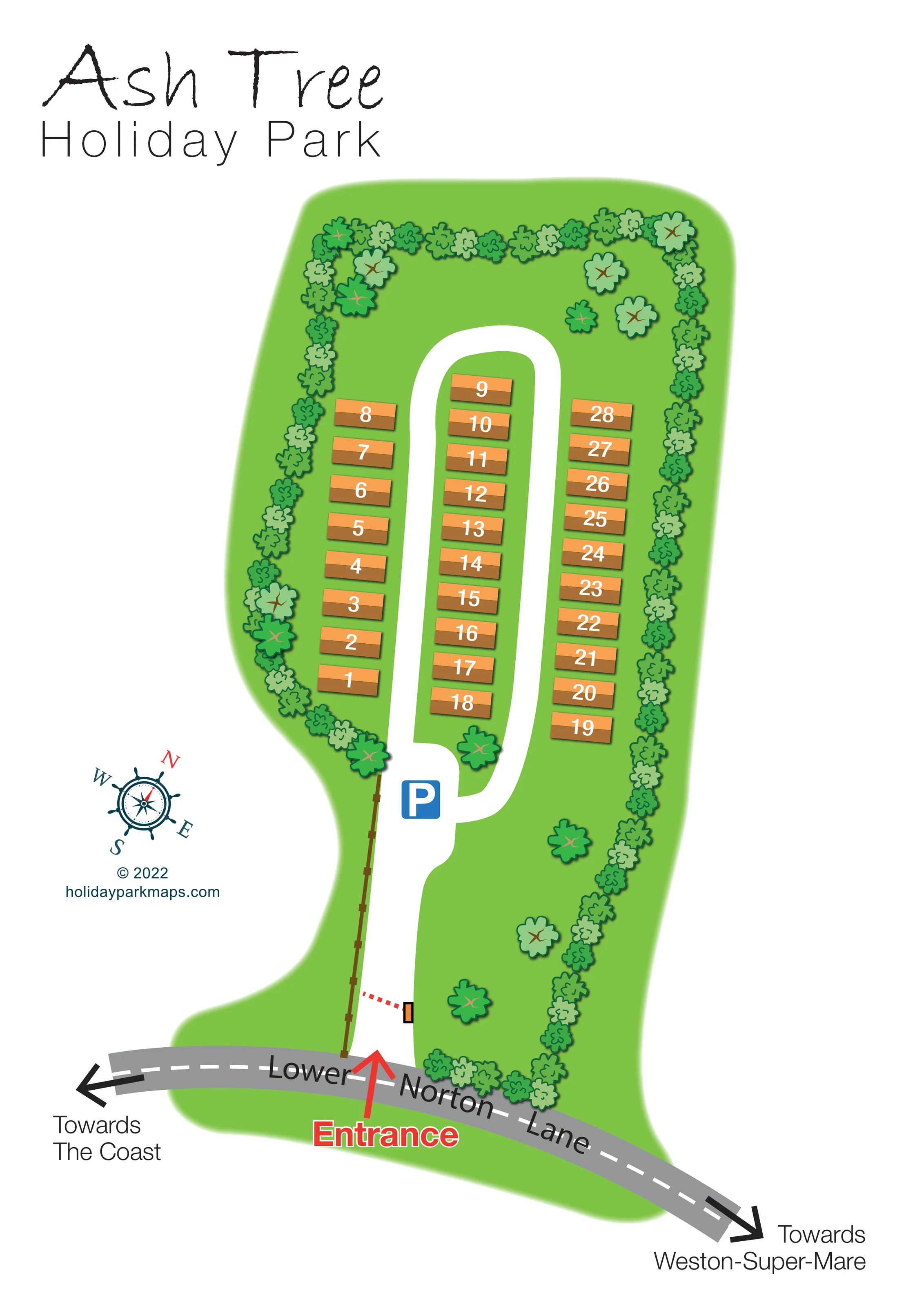
Closely spaced green tree and shrub symbols trace most of the park boundary, with larger individual trees scattered inside the grounds.
ILLUSTRATED PARK MAP · P011
Lower Norton Lane, Kewstoke, Weston-super-Mare · United Kingdom
 Enlarge the map ↗
A SENSE OF THE PLACE
Ash Tree Holiday Home Park is based at Lower Norton Lane, Kewstoke, Weston-super-Mare. A caravan dealer describes holiday homes offered for sale at this park.
The map brings the site layout and its access routes together in one view, providing a reference for understanding the arrangement of the grounds.
LOOK CLOSER
Closely spaced green tree and shrub symbols trace most of the park boundary, with larger individual trees scattered inside the grounds.
A bright green site shape includes open space beyond the rounded end of the loop and beside the long entrance approach.
A brown line with regularly spaced posts follows one side of the approach between Lower Norton Lane and the parking area.
A prominent red Entrance label and arrow mark the connection between the public road and the park's white access drive.
The entrance drive feeds a narrow rounded loop enclosing the central accommodation row and serving the two outer rows.
A blue P symbol marks a widened white area where the entrance drive meets the accommodation loop.
A short red dotted arm and orange rectangular component appear across part of the entrance drive, suggesting a barrier; no operating information is given.
A broad grey road with a dashed white centre line curves across the bottom of the page and is labelled directly along its course.
A prominent red Entrance label and arrow mark the connection between the public road and the park's white access drive.
The entrance drive feeds a narrow rounded loop enclosing the central accommodation row and serving the two outer rows.
A blue P symbol marks a widened white area where the entrance drive meets the accommodation loop.
A short red dotted arm and orange rectangular component appear across part of the entrance drive, suggesting a barrier; no operating information is given.
A broad grey road with a dashed white centre line curves across the bottom of the page and is labelled directly along its course.
Black arrows at opposite ends of Lower Norton Lane identify onward directions. The coast and town are references beyond the depicted site, not illustrated destinations.
Closely spaced green tree and shrub symbols trace most of the park boundary, with larger individual trees scattered inside the grounds.
A bright green site shape includes open space beyond the rounded end of the loop and beside the long entrance approach.
A brown line with regularly spaced posts follows one side of the approach between Lower Norton Lane and the parking area.
READING THE MAP
This illustrated map of Ash Tree Holiday Park presents a small holiday-home site at Lower Norton Lane, Kewstoke, near Weston-super-Mare. Its focus is straightforward: show where to enter, where parking is marked and how the numbered homes relate to the internal road. Around 30 holiday homes are represented by warm orange-and-brown blocks, set in three rows beside a long, rounded access loop.
The park appears as a bright green, tree-lined shape on a generous white page. A longer entrance drive separates the roadside arrival point from the accommodation, making the sequence easy to follow visually. At the foot of the plan, Lower Norton Lane curves between arrows pointing towards the coast and Weston-super-Mare, giving useful local orientation without adding a wider street map.
The design combines practical numbering with a lightly illustrative character. Scalloped tree crowns, a nautical-style compass and the informal Ash Tree heading soften the geometry, while the red entrance arrow and blue parking symbol draw attention to the most important arrival information.
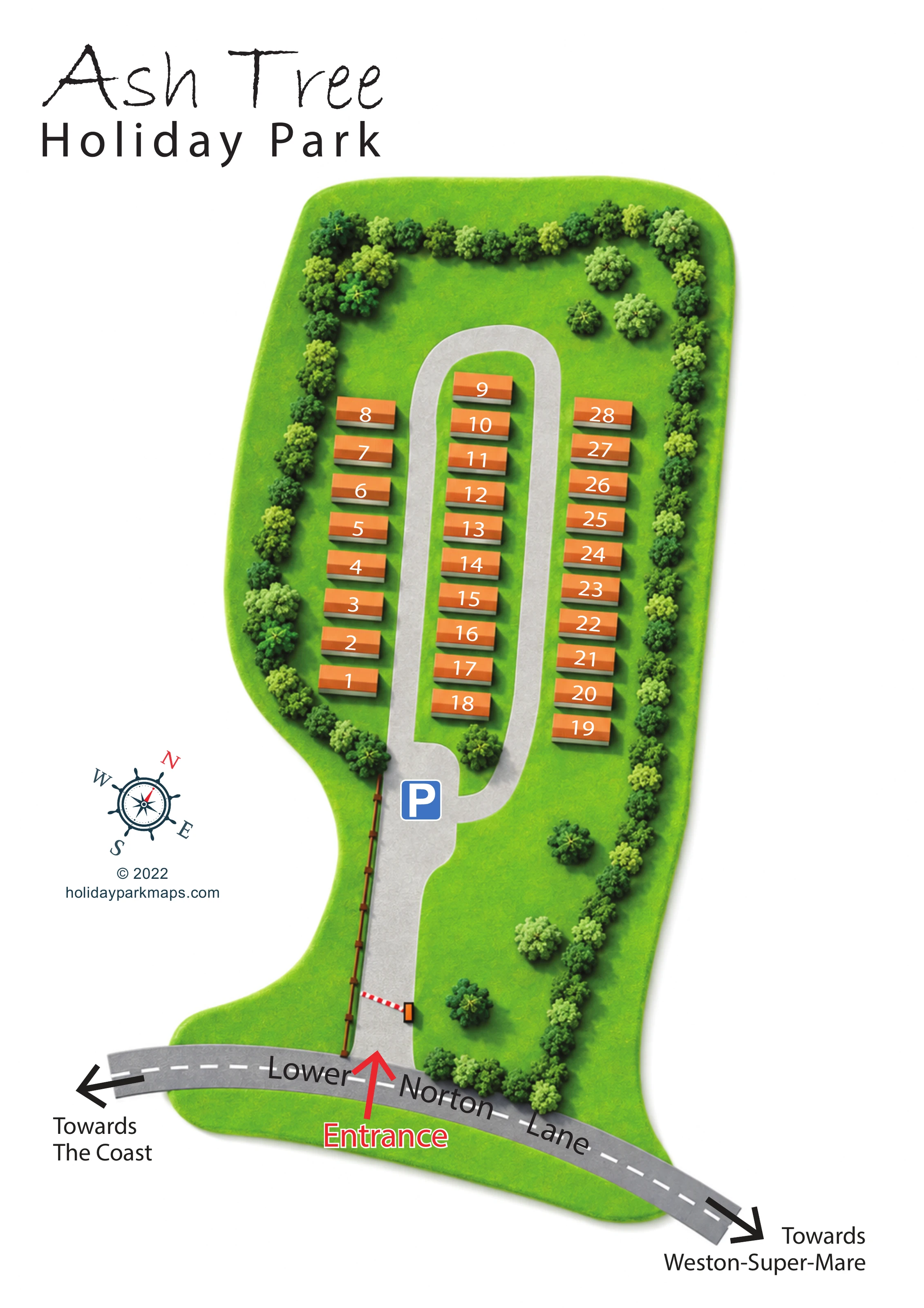
The portrait plan places the accommodation in the upper part of a narrow green site, reached by a white drive from Lower Norton Lane below. A red arrow and outlined Entrance label identify the turn into the park. A small barrier-like symbol crosses part of the approach, and a brown post-and-rail-style line follows one side of the drive. Further in, the route widens around a blue parking symbol before connecting with the elongated accommodation loop.
Three parallel rows give the residential area a simple, ordered structure. The middle row sits on the green strip enclosed by the loop, with the other rows positioned along its outer sides. Each holiday home is drawn as a two-tone orange-and-brown rectangle with a slight shadow and a large white number. The rounded upper end of the road leaves an open green area between the homes and the tree-lined boundary.
Foliage is an important part of the composition. Closely spaced small crowns outline much of the perimeter, while larger individual trees add variety beside the entrance approach and around the ends of the accommodation rows. The green ground has a softened outer edge rather than a hard surveyed boundary line.
Lower Norton Lane is visually distinct from the internal roads: grey surfacing, a dashed white centre line and curved black lettering establish it as the external approach. Opposing arrows name the coast and Weston-super-Mare. A rotated compass rose occupies the left-hand margin beneath the title, alongside the designer credit. There is no separate key or inset; direct labels and familiar symbols carry the navigation. The enlarged detail views show overlapping portions of this same single-page design.
 Enlarge this map ↗
KEEP EXPLORING
Chosen for shared landscapes, accommodation or facilities.
 Explore the map ↗
United Kingdom
Coastal park map with static-caravan rows, touring pitches, a camping field and two leisure clusters.
 Explore the map ↗
United Kingdom
Illustrated coastal holiday-home plan with dense alphanumeric plot labels, orange-roofed amenities, a numbered facility key and beach-side context.
 Explore the map ↗
United Kingdom
Colour-coded caravan plots and directional roads beside Hornsea’s coastal edge.
Features may come from the sample artwork, its key or published park information. Approximate numbers describe the drawing and may cover only part of a park. They are intended to help you compare map examples. Current facilities and booking information should be checked with the park.
LET’S MAP YOUR PARK
For a map quotation, find your park and draw a rough boundary around it. The area you select helps us work out the design time and price.
Draw your park for a quote ↗Or talk to our map designers
01751 473136