
Sea and rocky shoreline
Blue water, pale wave strokes, outlined stones and a grey rocky margin provide coastal context.
ILLUSTRATED PARK MAP · P394
Links Road, Amble, Northumberland · United Kingdom
 Enlarge the map ↗
A SENSE OF THE PLACE
Amble Links is a coastal holiday home park on the edge of Amble in Northumberland. Its appeal centres on owning a caravan or lodge close to the beach, with the harbour town and wider coastline available to explore.
The park offers a base for repeated holidays by the sea. The map presents the layout of the holiday home areas and routes through the site, helping owners and visitors understand their surroundings.
LOOK CLOSER
Blue water, pale wave strokes, outlined stones and a grey rocky margin provide coastal context.
Golden sand lies beyond the external road, carrying the dog-friendly designation. A separate arrow points towards Low Hauxley Beach.
Open green ground between road and shore contains grass tufts, paths and parking, without habitat or ownership information.
Repeated tree/shrub symbols outline the park and punctuate internal blocks; they are not a measured vegetation inventory.
Reception/information is represented on the plan by an information pictogram rather than its legend number.
Named security building beside the main entrance barrier.
A crossed-tools pictogram identifies a maintenance yard beside Security.
Named sales compound containing unnumbered orange/yellow building and display objects.
Reception/information is represented on the plan by an information pictogram rather than its legend number.
Named security building beside the main entrance barrier.
A crossed-tools pictogram identifies a maintenance yard beside Security.
Named sales compound containing unnumbered orange/yellow building and display objects.
Named multi-wing building associated with information, gym and emergency markers. A restaurant, bar or shop function is not explicitly stated.
A defibrillator location is marked; this is historical artwork evidence, not current emergency advice.
First-aid markers appear at the main building and sales compound.
Waste and recycling markers are distributed through the accommodation layout.
Fire-extinguisher markers cluster around principal amenity buildings.
An explicitly numbered assembly point and an additional assembly-style pictogram use different conventions.
A dog-friendly designation is placed on the beach outside the illustrated park boundary; present restrictions are unknown.
Dog-waste/bag points are distributed around internal roads and access points.
Dog-wash and laundry markers cluster beside a small western service building.
Marked-bay parking appears inside the park and in the external coastal context; ownership and access arrangements are unspecified.
A tan tennis court is drawn with white court markings.
The gym marker is attached to a lower wing of the main building.
Laundry is indicated at the western service building beside the dog-wash marker.
An apparent play area is indicated by an unkeyed playhouse-and-slide pictogram.
Blue water, pale wave strokes, outlined stones and a grey rocky margin provide coastal context.
Golden sand lies beyond the external road, carrying the dog-friendly designation. A separate arrow points towards Low Hauxley Beach.
Open green ground between road and shore contains grass tufts, paths and parking, without habitat or ownership information.
Repeated tree/shrub symbols outline the park and punctuate internal blocks; they are not a measured vegetation inventory.
READING THE MAP
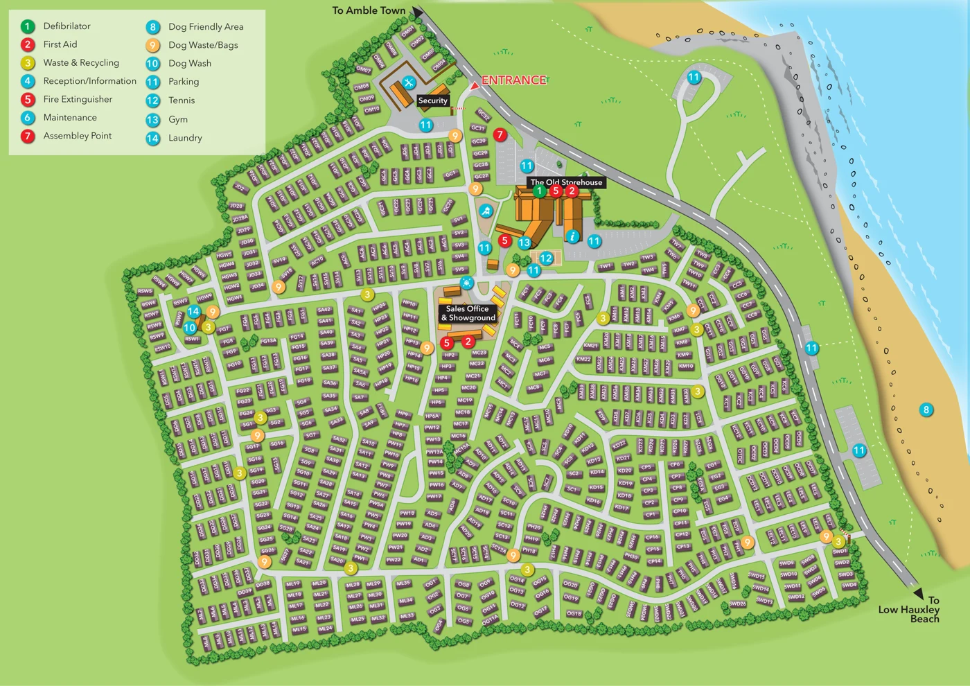
This Amble Links sample demonstrates how a densely developed holiday park can be organised into a readable illustrated plan. The coastal Northumberland park is shown with many individual accommodation positions connected by internal roads, with letter-and-number labels helping visitors find the right part of the site.
The artwork gives the accommodation a consistent visual treatment while using stronger labels and symbols for important destinations. Facilities and shared spaces provide landmarks within the extensive layout, and the entrance is given particular visual emphasis. A sales showground is identified separately from the accommodation areas.
This is a useful design reference for larger holiday-home parks where clear wayfinding is as important as an attractive overall impression. It demonstrates the role of consistent unit symbols, legible plot references and a clear road network in presenting a complex site. For the gallery and sample-search assistant, its main strengths are scale, accommodation density and the treatment of a large number of individual positions.
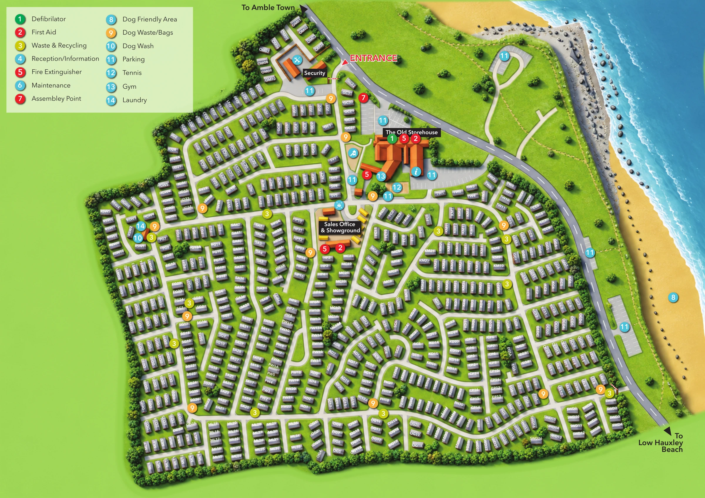
This single-page landscape plan presents a densely arranged coastal holiday-home park within an irregular, tree-edged boundary. Accommodation fills most of the lower and left-hand portions of the page, while a curving coastal road, open green strip, sandy beach and blue sea occupy the right. Direction arrows point towards Amble Town at the top and Low Hauxley Beach at the lower-right corner. No compass or scale bar is provided.
The accommodation layer uses repeated purple rectangular roof symbols with two-tone shading and soft shadows. White alphanumeric labels rotate with the individual symbols, and recurring prefixes organise neighbouring groups. Pale-grey internal roads form parallel lanes, curved loops, cross-roads and short spurs. The artwork does not distinguish caravans from lodges through either colour or a separate accommodation key.
At the narrow upper entrance, Security, a barrier, parking and a maintenance pictogram establish the arrival sequence. The Old Storehouse forms the principal orange-roofed landmark farther into the site. Information, gym and emergency markers cluster around its wings, with a tennis court below and an unkeyed playhouse-and-slide pictogram to the left. The Sales Office & Showground continues the amenity spine, although its large black panel partly hides the display objects. A smaller western service cluster carries laundry and dog-wash markers.
A pale-green, two-column legend occupies the upper-left corner. Coloured numbered circles identify facilities including first aid, waste and recycling, dog-waste points and parking. Some mapped locations instead use pictograms, creating a consistency issue for the key. Repeated trees and shrubs outline the site, while grass tufts, shore rocks and wave strokes distinguish the coastal landscape. The overall approach combines practical plot finding with an attractive setting illustration; its dense rotated labels are substantially easier to read in the supplied detail views than in the overview.
 Enlarge this map ↗
KEEP EXPLORING
Chosen for shared landscapes, accommodation or facilities.
 Explore the map ↗
United Kingdom
A colour-zoned coastal park map with touring areas, woodland trails, ponds and a leisure club.
 Explore the map ↗
United Kingdom
Colour-coded accommodation, central leisure facilities and coastal paths on an illustrated headland park map.
 Explore the map ↗
United Kingdom
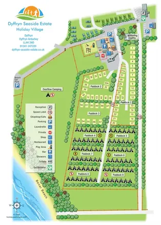
Portrait seaside park map with nine paddocks, an amenities hub and illustrated Benar Beach.
Features may come from the sample artwork, its key or published park information. Approximate numbers describe the drawing and may cover only part of a park. They are intended to help you compare map examples. Current facilities and booking information should be checked with the park.
LET’S MAP YOUR PARK
For a map quotation, find your park and draw a rough boundary around it. The area you select helps us work out the design time and price.
Draw your park for a quote ↗Or talk to our map designers
01751 473136