
Celtic Sea frontage
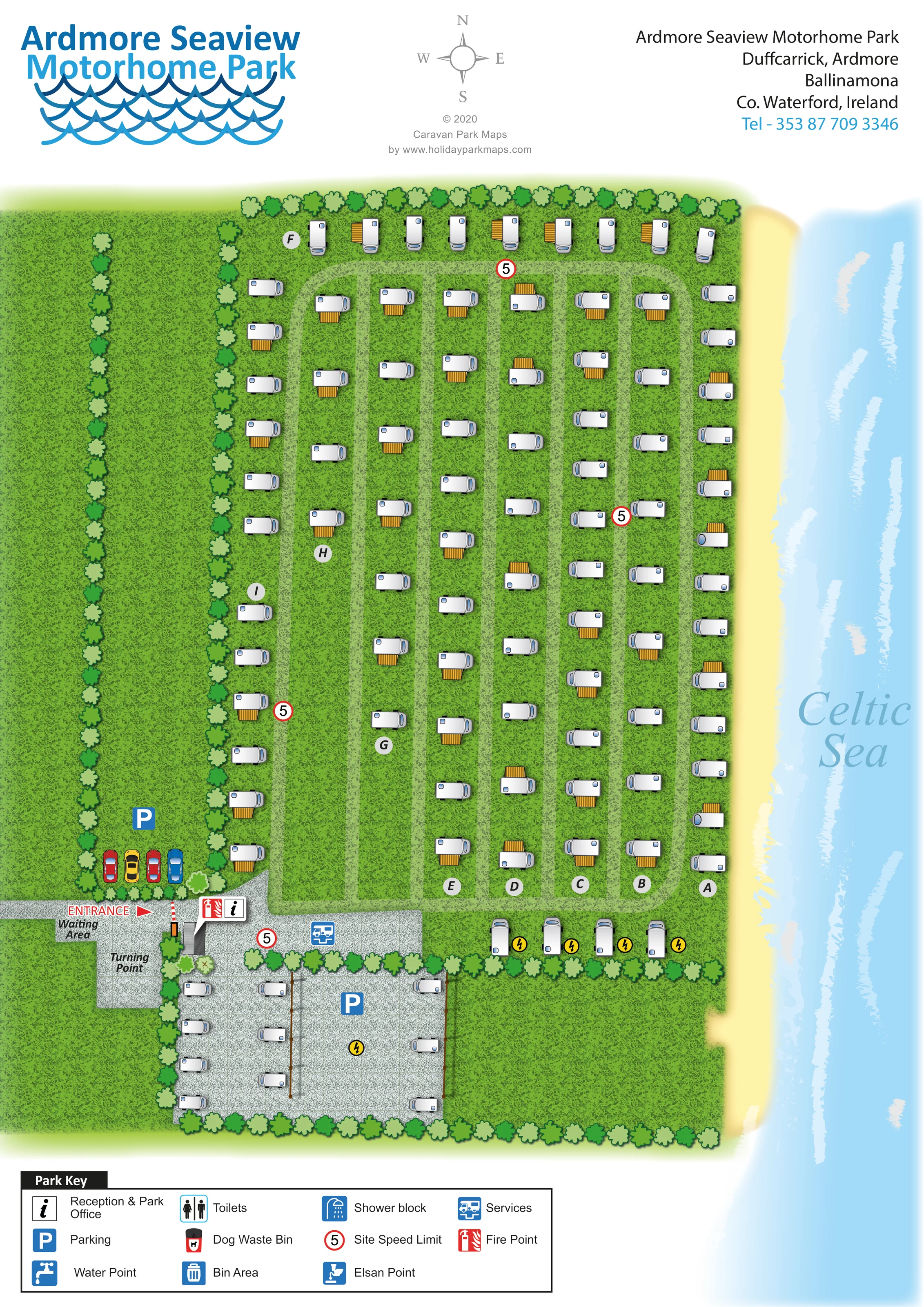
The eastern edge is illustrated as a pale sandy shoreline beside blue water and white breaking waves, labelled Celtic Sea.
ILLUSTRATED PARK MAP · P395
Duffcarrick, Ardmore, Ballinamona, Co. Waterford · Ireland
 Enlarge the map ↗
A SENSE OF THE PLACE
Ardmore Seaview Motorhome Park is a coastal motorhome stop at Duffcarrick in County Waterford. Its location offers sea views and access to the village of Ardmore.
The map shows the motorhome layout and marked service areas beside the coast. Visitor listings describe electric connections and water and waste-disposal provision, making it a base for self-contained touring vehicles.
LOOK CLOSER
The eastern edge is illustrated as a pale sandy shoreline beside blue water and white breaking waves, labelled Celtic Sea.
Textured green grounds contain the main motorhome rows and broader open strips west of the accommodation.
Alternating light and dark green tree symbols define the northern, western and southern edges and divide the western green areas.
A west-side approach enters near the south-west corner, with a red entrance arrow and a striped barrier.
Both are labelled beside the entrance, with the turning space extending south from the approach.
Circular markers A–I identify the accommodation rows rather than individual numbered pitches.
An information symbol locates reception and the park office at the entrance junction.
Blue P symbols identify a western car-parking area and the larger gravel area south of the main rows.
The eastern edge is illustrated as a pale sandy shoreline beside blue water and white breaking waves, labelled Celtic Sea.
Textured green grounds contain the main motorhome rows and broader open strips west of the accommodation.
Alternating light and dark green tree symbols define the northern, western and southern edges and divide the western green areas.
A west-side approach enters near the south-west corner, with a red entrance arrow and a striped barrier.
Both are labelled beside the entrance, with the turning space extending south from the approach.
Circular markers A–I identify the accommodation rows rather than individual numbered pitches.
An information symbol locates reception and the park office at the entrance junction.
Blue P symbols identify a western car-parking area and the larger gravel area south of the main rows.
A blue motorhome-services symbol is placed on the gravel approach immediately inside the entrance.
Yellow lightning-bolt symbols appear beside the southern motorhome positions and within the gravel area; they are not explained in the printed key.
A red fire-point symbol is paired with the reception marker at the entrance.
Repeated red-ringed 5 signs mark the entrance and internal routes. The artwork does not specify a speed unit.
Listed in the park key, without a clearly identifiable matching location on the plan.
Both waste symbols are explained in the key, but their positions are not clearly marked in the main illustration.
An Elsan disposal symbol appears in the key; no separate location can confidently be assigned from the plan.
Separate toilet and shower-block symbols are included in the key, without clearly identifiable placements in the artwork.
READING THE MAP
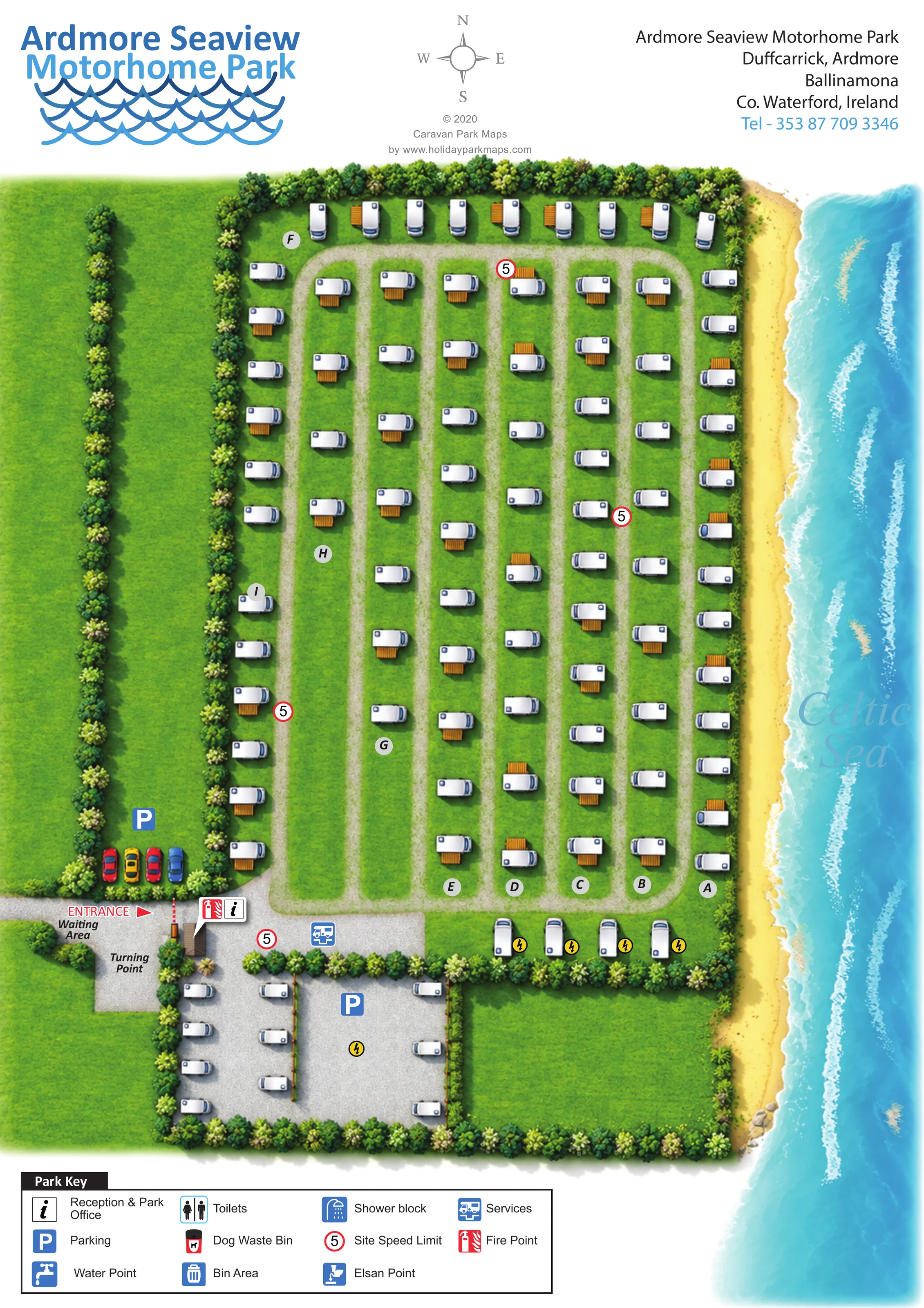
This illustrated map of Ardmore Seaview Motorhome Park places its coastal setting at the centre of the design. The Celtic Sea runs down the right-hand side, with a pale sandy edge and white wave strokes beside long rows of motorhomes. Textured green grounds and tree-lined boundaries give the accommodation grid a softer, landscape-led appearance.
The plan presents a motorhome-focused site of roughly 100 illustrated vehicle positions. Lettered rows organise the main grass area, while a smaller gravel section sits near the entrance. Visitors arriving from the west can identify the waiting area, turning point, reception marker, parking and motorhome services before following the internal lanes.
A large blue title and wave motif establish the park identity above the map, and a boxed key explains the facility symbols below. This sample is particularly relevant to coastal motorhome parks needing a clear arrival layout, recognisable accommodation rows and an illustration that communicates the seaside setting without relying on a technical survey drawing.
The single portrait plan shows a long coastal site arranged alongside the Celtic Sea. Most motorhomes sit in parallel north–south rows on textured grass, with pale internal lanes separating them. Circular A–I markers distinguish the rows, while a transverse line of vehicles runs across the northern end. The sea-facing row follows the eastern boundary immediately beside the illustrated shoreline. White vehicle bodies, grey shading and orange striped awnings make the repeated accommodation symbols easy to recognise.
Arrival is concentrated near the south-west corner. A red entrance arrow leads to a striped barrier, with a waiting area and a separate turning point labelled alongside the approach. Reception and a fire point share a prominent marker at this junction. A blue services symbol appears just inside the site, and parking is marked both beside the western car illustrations and within the southern gravel area. Additional motorhomes occupy this gravel section, where yellow lightning symbols also appear. Red-ringed 5 signs recur along the internal routes.
Tree symbols frame the grounds and divide broad green strips to the west. Along the opposite edge, a softly shaded yellow shore meets pale blue water, long white wave marks and large Celtic Sea lettering. The header combines the park’s blue wave-themed identity, a compass, designer credit and contact block.
The lower key explains reception, parking, water, waste, toilets, showers, services and safety symbols. Some of these appear only in the key rather than at identifiable positions on the plan. The two enlarged detail views reproduce portions of this same key; they are not separate maps or additional accommodation areas.
 Enlarge this map ↗
KEEP EXPLORING
Chosen for shared landscapes, accommodation or facilities.
 Explore the map ↗
Ireland
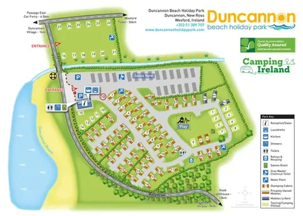
Beachside park plan with colour-coded mobile homes, touring/camping areas, glamping cabins and grouped service symbols.
 Explore the map ↗
United Kingdom
Illustrated Sanday aire map with a seasonal maze, café barn and motorhome service area.
 Explore the map ↗
United Kingdom
Coastal park map with static-caravan rows, touring pitches, a camping field and two leisure clusters.
Features may come from the sample artwork, its key or published park information. Approximate numbers describe the drawing and may cover only part of a park. They are intended to help you compare map examples. Current facilities and booking information should be checked with the park.
TAKE A CLOSER LOOK
View the illustrated map in detail or choose a file to download. These are sample maps; contact the park for current visitor information.


LET’S MAP YOUR PARK
For a map quotation, find your park and draw a rough boundary around it. The area you select helps us work out the design time and price.
Draw your park for a quote ↗Or talk to our map designers
01751 473136