
Planted and fenced boundaries
Illustrated hedges and trees frame the western and northern edges; fences divide the pitch enclosure, roadside grass and recreation area.
ILLUSTRATED PARK MAP · P397
Ashlar Farm Motorhome Aire, Machrie, Isle of Arran · United Kingdom
 Enlarge the map ↗
A SENSE OF THE PLACE
Ashlar Farm Motorhome Aire provides a small overnight stopping place at Machrie on Arran's west coast. Level hardstanding pitches have electric connections and Wi-Fi.
A service point supplies fresh water and facilities for grey water and chemical waste, alongside rubbish and recycling provision. The aire is designed around practical motorhome stopovers on the island's western coast.
LOOK CLOSER
Illustrated hedges and trees frame the western and northern edges; fences divide the pitch enclosure, roadside grass and recreation area.
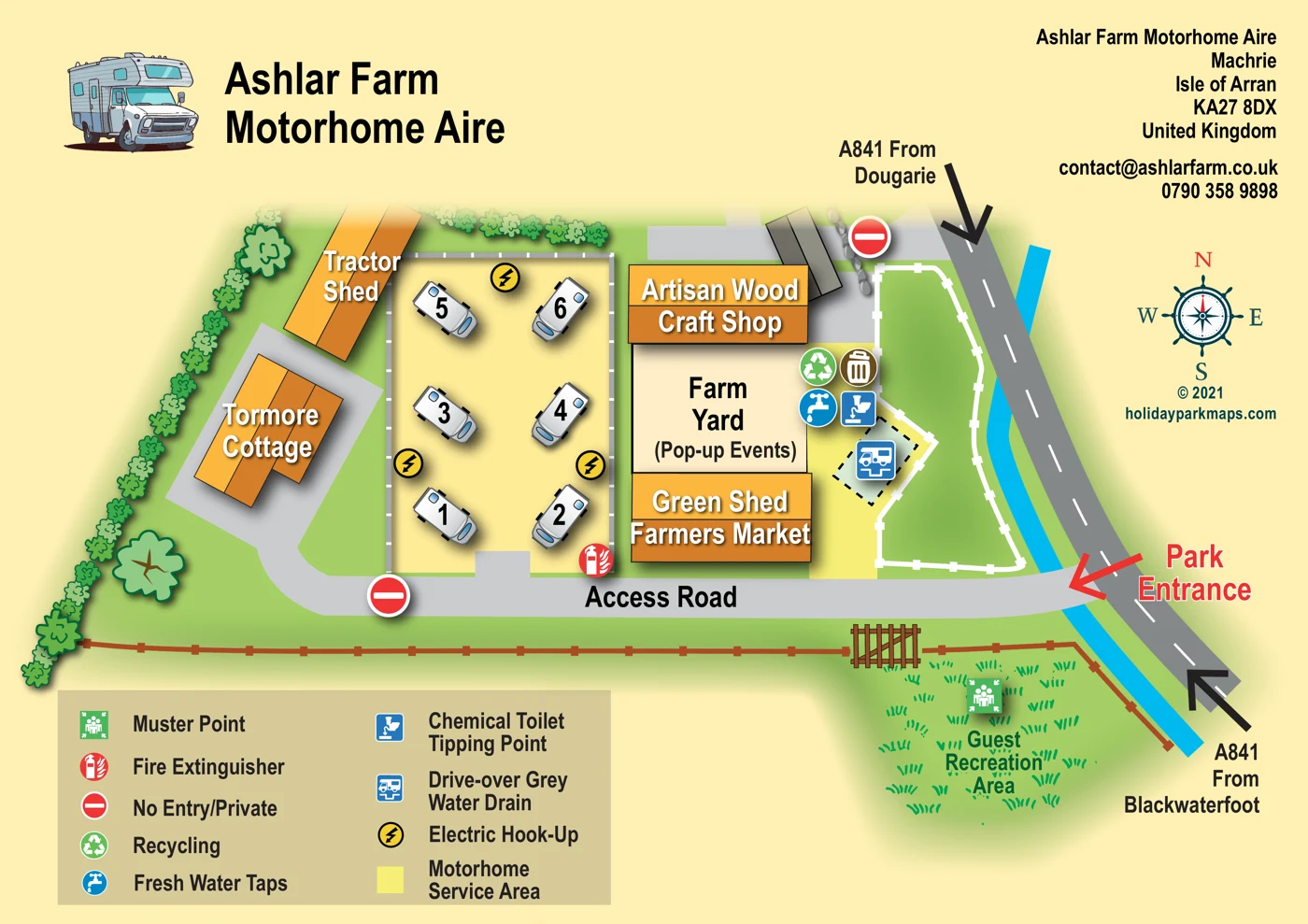
A compact numbered motorhome area occupies the centre-left of the plan, with vehicles arranged in two columns.
Yellow lightning symbols identify electric hook-ups within the motorhome area.
A yellow-highlighted servicing area lies beside the farm yard and includes an angled drive-over disposal pad.
The blue tap symbol is positioned beside the eastern edge of the farm yard.
A chemical-toilet disposal symbol appears beside the fresh water and waste facilities.
A blue motorhome-and-drain symbol marks an angled pad in the service area.
Recycling and rubbish-bin symbols are grouped beside the farm yard.
A compact numbered motorhome area occupies the centre-left of the plan, with vehicles arranged in two columns.
Yellow lightning symbols identify electric hook-ups within the motorhome area.
A yellow-highlighted servicing area lies beside the farm yard and includes an angled drive-over disposal pad.
The blue tap symbol is positioned beside the eastern edge of the farm yard.
A chemical-toilet disposal symbol appears beside the fresh water and waste facilities.
A blue motorhome-and-drain symbol marks an angled pad in the service area.
Recycling and rubbish-bin symbols are grouped beside the farm yard.
A labelled grassy recreation area sits south of the access road, beside a fence and gate.
A green muster-point symbol is placed within the guest recreation area.
A red extinguisher symbol is shown at the lower-right corner of the motorhome area.
The central farm yard is explicitly labelled for pop-up events.
A prominent orange-roofed building north of the farm yard is labelled Artisan Wood Craft Shop.
The building immediately south of the farm yard is labelled Green Shed Farmers Market.
A long orange-roofed tractor shed stands northwest of the motorhome pitches.
Tormore Cottage is a labelled building west of the motorhome area; the map does not identify it as visitor accommodation.
A red arrow marks the entrance from the A841, with approach arrows from Dougarie and Blackwaterfoot.
The grey access road runs along the southern side of the pitches and farm buildings, connecting them to the entrance.
No-entry/private symbols mark the western driveway and a northern approach beside the craft shop.
Illustrated hedges and trees frame the western and northern edges; fences divide the pitch enclosure, roadside grass and recreation area.
Published park information describes Wi-Fi provision, although no Wi-Fi symbol is shown on the plan.
READING THE MAP
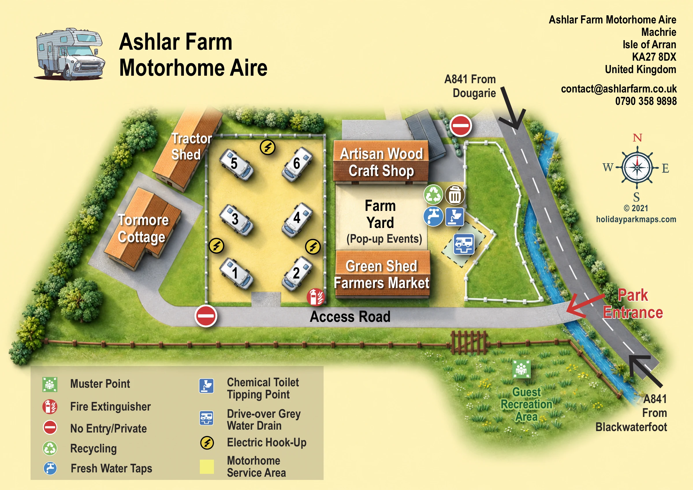
A small motorhome aire needs a different kind of map from a sprawling holiday park. This illustrated plan of Ashlar Farm Motorhome Aire at Machrie on the Isle of Arran focuses on the essentials: where to turn in, where the motorhome pitches sit, and where to find water, waste disposal and electric hook-ups.
The compact pitch area is drawn beside a group of farm buildings, each given a distinctive shape and prominent label. Tormore Cottage and the tractor shed help orientate visitors on one side, while the artisan wood craft shop, farm yard and Green Shed Farmers Market establish the character of the other. A separate grassy guest recreation area adds another useful landmark.
Clear arrows show the A841 approaches from Dougarie and Blackwaterfoot, with the park entrance highlighted in red. The warm cream background, orange roofs and illustrated motorhomes give the page an informal rural feel, while the colour-coded facilities legend keeps the practical information easy to find.
The plan centres on a compact rectangular motorhome area, with numbered vehicle illustrations arranged in two columns on a pale yellow surface. Electric hook-up symbols sit within this enclosure, which opens onto the access road along its southern edge. A red fire-extinguisher symbol marks the lower-right corner of the pitch area.
To the west, a curved grey driveway passes Tormore Cottage and the long tractor shed. To the east, three strongly labelled spaces form a vertical group: the Artisan Wood Craft Shop, the Farm Yard marked for pop-up events, and the Green Shed Farmers Market. Water, chemical-toilet disposal, recycling and rubbish symbols are grouped beside the eastern edge of the farm yard. A drive-over grey-water drain is shown on an angled pad within the adjoining yellow service area.
The access road leads directly from the A841 on the right-hand side of the page. A large red entrance arrow contrasts with black approach arrows labelled from Dougarie and Blackwaterfoot. No-entry symbols mark two private approaches, and a white fence outlines the green roadside enclosure. Below the access road, a brown fence and gate define the edge of a grassy guest recreation area, where the muster-point symbol is placed.
The artwork combines a largely overhead layout with slightly raised, shaded buildings and motorhomes. Orange roofs, green lawns and hedges, grey roads and blue service symbols stand out against a pale cream background. A large motorhome illustration and title occupy the upper left; address and contact details sit at the upper right. The lower-left legend, right-hand compass and bold labels complete a clear, self-contained arrival map.
 Enlarge this map ↗
KEEP EXPLORING
Chosen for shared landscapes, accommodation or facilities.
 Explore the map ↗
United Kingdom
Illustrated Sanday aire map with a seasonal maze, café barn and motorhome service area.
 Explore the map ↗
United Kingdom
A colour-coded touring park plan with named pitch areas, service symbols and Coast Path links.
 Explore the map ↗
United Kingdom
Tree-framed mixed-accommodation park map with two entrances, touring loops and a clearly illustrated social hub.
Features may come from the sample artwork, its key or published park information. Approximate numbers describe the drawing and may cover only part of a park. They are intended to help you compare map examples. Current facilities and booking information should be checked with the park.
LET’S MAP YOUR PARK
For a map quotation, find your park and draw a rough boundary around it. The area you select helps us work out the design time and price.
Draw your park for a quote ↗Or talk to our map designers
01751 473136