
Church Bay beach
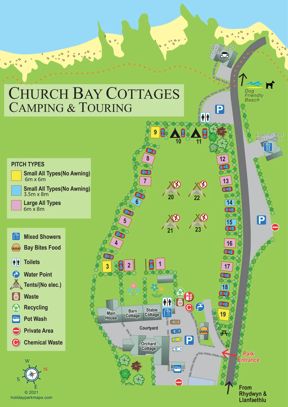
A pale beach strip and blue sea span the top of the artwork. An arrow and dog illustration accompany the label 'Dog Friendly Beach'.
ILLUSTRATED PARK MAP · P444
Ty Newydd, Church Bay, Rhydwyn, Holyhead, Isle of Anglesey · United Kingdom
 Enlarge the map ↗
A SENSE OF THE PLACE
Church Bay Cottages and Campsite is a family-run site near the beach at Church Bay on Anglesey. Converted buildings associated with the historic Ty Newydd farmhouse provide self-catering cottages alongside camping and touring pitches.
Electric and non-electric options accommodate different camping needs, and Wi-Fi is provided on site. Coastal walking, beach activities and nearby places to eat are central to the appeal of this north-west Anglesey location.
LOOK CLOSER
A pale beach strip and blue sea span the top of the artwork. An arrow and dog illustration accompany the label 'Dog Friendly Beach'.
Repeated hedge illustrations enclose the field and separate pitch spaces; trees and flower motifs mark the cottage gardens.
Three named self-catering cottages—Barn Cottage, Stable Cottage and Orchard Cottage—are arranged around the lower courtyard area.
The Main House is labelled beside Barn Cottage and Stable Cottage in the connected building group.
Numbered, colour-coded all-type pitches line the field boundary. The key distinguishes large pitches and two smaller categories labelled without awnings.
Tent symbols occupy the central grass and the upper edge of the field; the service key identifies the larger tent symbol as non-electric camping.
A mixed-shower symbol appears beside the courtyard building group.
Toilet symbols are shown near the courtyard and beside the external parking area towards the beach.
Three named self-catering cottages—Barn Cottage, Stable Cottage and Orchard Cottage—are arranged around the lower courtyard area.
The Main House is labelled beside Barn Cottage and Stable Cottage in the connected building group.
Numbered, colour-coded all-type pitches line the field boundary. The key distinguishes large pitches and two smaller categories labelled without awnings.
Tent symbols occupy the central grass and the upper edge of the field; the service key identifies the larger tent symbol as non-electric camping.
A mixed-shower symbol appears beside the courtyard building group.
Toilet symbols are shown near the courtyard and beside the external parking area towards the beach.
A water-point symbol is placed beside the entrance-side service cluster.
A pot-wash symbol appears at a small building towards the lower edge of the plan.
Waste and recycling symbols are grouped beside the cottage courtyard.
The red chemical-waste symbol is shown in the courtyard service cluster.
A burger symbol matching the Bay Bites Food legend entry marks a small entrance-side building.
A picnic-table illustration sits near Bay Bites Food and the park entrance.
Wavecrest Cafe is labelled beside an illustrated building near the beach and upper end of the road.
Lobster Pot Restaurant is labelled on the opposite side of the road from the camping field.
Blue parking symbols identify courtyard parking and separate roadside parking areas outside the campsite.
A red arrow marks the entrance from the road into the courtyard end of the site.
The approach arrow is labelled 'From Rhydwyn & Llanfaethlu'; the road continues along the eastern-looking edge of the page towards the shore.
Red no-entry-style symbols identify private areas on the road and at the lower edge of the site, as explained by the key.
A pale beach strip and blue sea span the top of the artwork. An arrow and dog illustration accompany the label 'Dog Friendly Beach'.
Repeated hedge illustrations enclose the field and separate pitch spaces; trees and flower motifs mark the cottage gardens.
An orange dotted line follows the shore-side green strip, but it has no explicit route label or legend explanation.
Published park information describes electric and non-electric camping options; the artwork explicitly identifies non-electric tent camping but does not individually label electrical connections.
On-site Wi-Fi is described in published park information, rather than located by a symbol on this map.
READING THE MAP
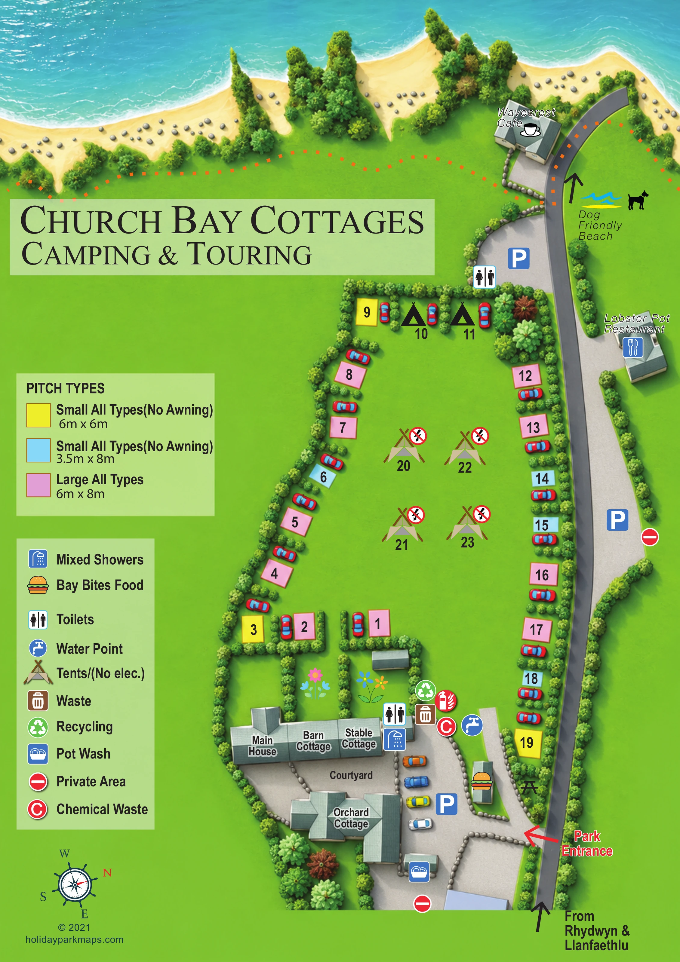
This illustrated map of Church Bay Cottages Camping and Touring brings together a small Anglesey campsite, a group of farmhouse-associated holiday cottages and the coastal places visitors are likely to recognise on arrival. The beach and blue sea stretch across the top of the artwork, while the road from Rhydwyn and Llanfaethlu runs along the right-hand edge to the clearly marked park entrance.
The accommodation is organised around two distinct spaces: a hedge-lined camping and touring field, and a cottage courtyard containing named buildings, parking and shared facilities. Numbered pitches use three colours to communicate the size categories shown in the key, with separate tent symbols identifying non-electric camping. Simple illustrated roofs help distinguish the Main House, Barn Cottage, Stable Cottage and Orchard Cottage from the pitch area.
The map also includes Wavecrest Cafe, Lobster Pot Restaurant and the labelled beach beyond the campsite. Its combination of local landmarks, practical service symbols and a generous portrait layout makes it a useful example for small coastal parks that need to explain both their own accommodation and their immediate surroundings.
The portrait map places the sea and a pale sandy shoreline across the top, with a grey approach road following the right-hand side. An arrow identifies arrival from Rhydwyn and Llanfaethlu at the bottom, and a red entrance arrow points into the site near the cottage courtyard. The road continues past the Lobster Pot Restaurant towards Wavecrest Cafe and the beach, with separate parking symbols and a toilet symbol shown outside the campsite.
Inside the hedge-lined boundary, numbered pitches form a broad horseshoe around an open grassy centre. Pink, yellow and blue rectangles distinguish the three pitch-size categories. The key identifies large all-type pitches measuring 6m × 8m and two small all-type categories, measuring 6m × 6m and 3.5m × 8m, both labelled without awnings. Car illustrations sit beside many pitches. Black tent silhouettes appear at the coastal end, while larger tent symbols in the middle denote non-electric camping.
At the lower end, the Main House, Barn Cottage and Stable Cottage occupy a connected building group beside the courtyard. Orchard Cottage is illustrated opposite, with roof shapes and angled walls giving the buildings a modest sense of depth. Courtyard parking, mixed showers, toilets, water, waste, recycling and chemical-waste symbols are clustered nearby. A pot-wash point sits towards the lower edge, while Bay Bites Food and a picnic-table illustration occupy the entrance-side area.
Repeated hedge shapes enclose the pitches and divide garden spaces; larger trees and stylised flowers soften the cottage area. An orange dotted line follows the coastal margin, and a beach arrow accompanies the map’s ‘Dog Friendly Beach’ label. A decorative compass, pale-green legend panels and large serif title complete the composition.
 Enlarge this map ↗
KEEP EXPLORING
Chosen for shared landscapes, accommodation or facilities.
 Explore the map ↗
United Kingdom
Coastal park map with static-caravan rows, touring pitches, a camping field and two leisure clusters.
 Explore the map ↗
United Kingdom
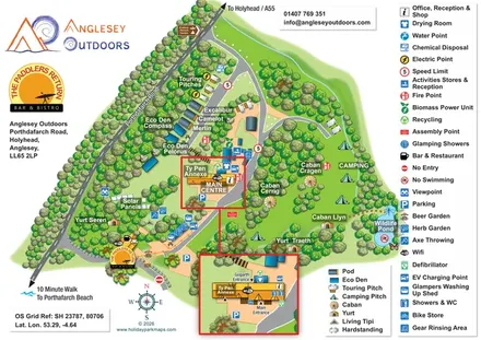
Illustrated camping and glamping map with an activity-centre inset and wildlife pond.
 Explore the map ↗
United Kingdom
Coastal park plan with colour-coded pitches, named neighbourhoods and a Morecambe Bay walking route.
Features may come from the sample artwork, its key or published park information. Approximate numbers describe the drawing and may cover only part of a park. They are intended to help you compare map examples. Current facilities and booking information should be checked with the park.
LET’S MAP YOUR PARK
For a map quotation, find your park and draw a rough boundary around it. The area you select helps us work out the design time and price.
Draw your park for a quote ↗Or talk to our map designers
01751 473136