
Tree-lined stream
A narrow, winding blue watercourse runs through the left-central accommodation and continues beside the recreation field and lower holiday-home cluster.
ILLUSTRATED PARK MAP · P443
West Witton, Leyburn, North Yorkshire · United Kingdom
 Enlarge the map ↗
A SENSE OF THE PLACE
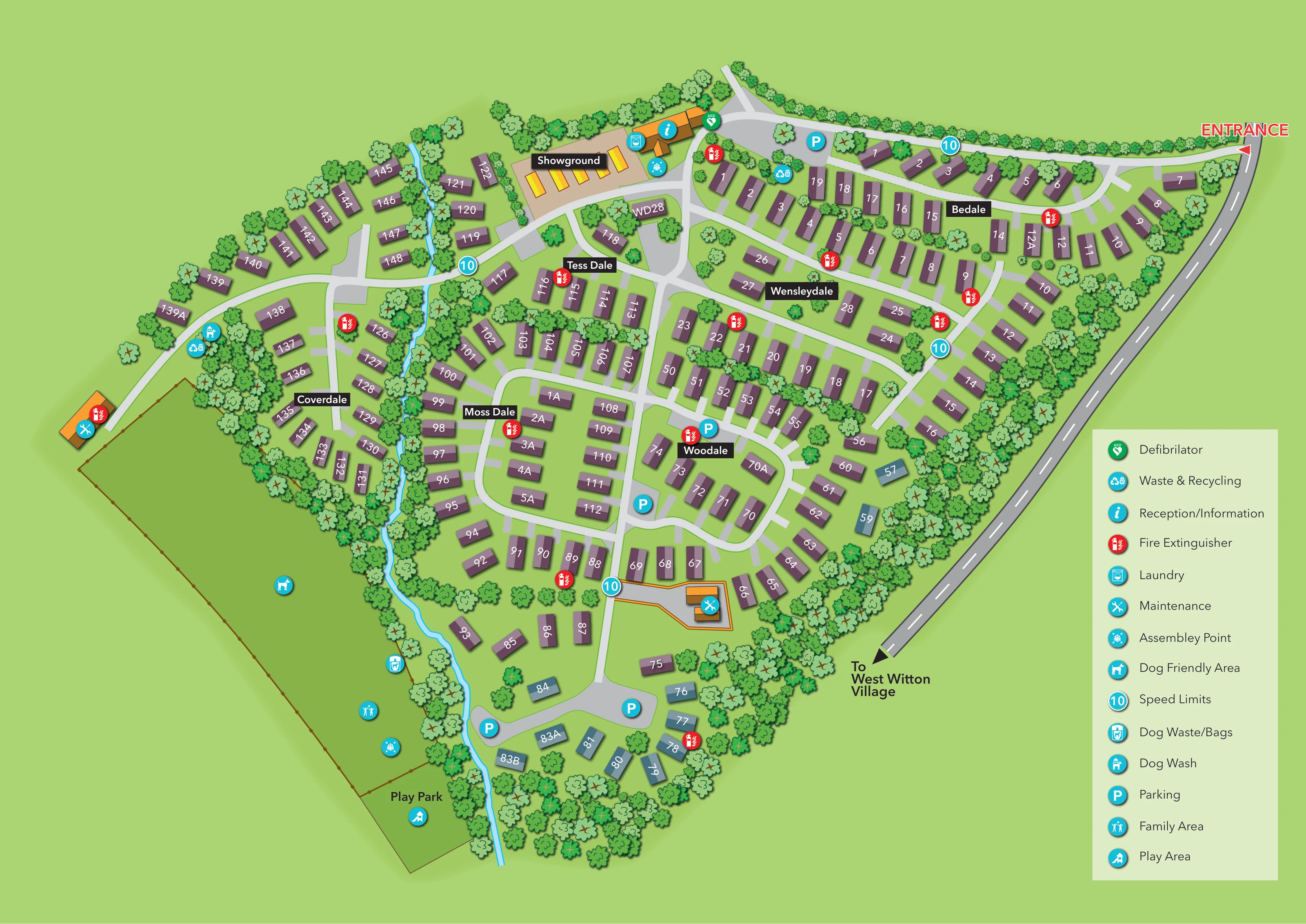
Chantry Country and Leisure Park is located in Wensleydale near West Witton. Landscaped gardens and water features give the holiday home park a distinctive countryside setting.
Published park information describes an owners' lounge, gym, children's play area and launderette. Its location provides a base for exploring the Yorkshire Dales, while the map illustrates the layout of holiday homes and shared facilities.
LOOK CLOSER
A narrow, winding blue watercourse runs through the left-central accommodation and continues beside the recreation field and lower holiday-home cluster.
Dense perimeter planting, tree belts along the stream and smaller groups between accommodation rows establish the park's landscaped character.
Information symbol on the orange-roofed building beside the showground, near the upper road junction.
Laundry symbol attached to the reception-side building complex.
Named tan-surfaced display area with a short row of yellow-orange units beside reception.
Maintenance symbols identify an outlying building at the left edge and an orange-outlined service compound in the lower central part of the park.
Several cyan parking markers sit on grey parking bays near reception, Woodale and the lower accommodation roads.
Grouped waste and recycling symbols appear near the upper accommodation area and on the left side beside the dog wash.
Information symbol on the orange-roofed building beside the showground, near the upper road junction.
Laundry symbol attached to the reception-side building complex.
Named tan-surfaced display area with a short row of yellow-orange units beside reception.
Maintenance symbols identify an outlying building at the left edge and an orange-outlined service compound in the lower central part of the park.
Several cyan parking markers sit on grey parking bays near reception, Woodale and the lower accommodation roads.
Grouped waste and recycling symbols appear near the upper accommodation area and on the left side beside the dog wash.
Green AED marker beside the reception complex and upper junction.
Repeated red fire extinguisher symbols distributed throughout the accommodation roads and service areas.
Assembly-point symbols appear beside reception and in the large recreation field.
Dog symbol identifies part of the large enclosed green field to the left of the accommodation. This is a mapped area, not evidence of a park-wide pet policy.
Dog-wash marker on the left side of the park, beside a waste and recycling point.
Dog waste/bags marker along the recreation-field boundary beside the stream.
Family-area symbol within the large green recreation field.
Named Play Park in a separately outlined section at the lower end of the recreation field, with a matching play-area symbol.
A narrow, winding blue watercourse runs through the left-central accommodation and continues beside the recreation field and lower holiday-home cluster.
Dense perimeter planting, tree belts along the stream and smaller groups between accommodation rows establish the park's landscaped character.
Large red entrance label and arrow mark the upper-right connection from the external road to the internal road network.
The grey external road follows the right edge of the park and ends with a directional arrow labelled To West Witton Village.
Pale internal roads link curved loops, branching lanes, parking bays and short individual access strips.
Black labels identify Bedale, Wensleydale, Tess Dale, Coverdale, Moss Dale and Woodale.
Circular markers displaying 10 appear at several points on the internal roads; the legend identifies them as speed limits.
READING THE MAP
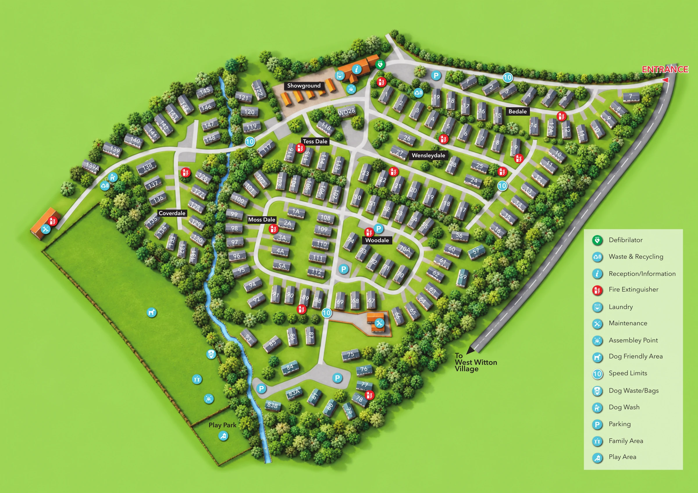
This illustrated map of Chantry Holiday Park presents a landscaped holiday-home setting near West Witton in Wensleydale, North Yorkshire. Its most distinctive feature is a narrow blue stream edged with dense trees, running between the accommodation and a broad green recreation field. Curved roads, planted boundaries and small groups of trees soften the rows of numbered homes while keeping the overall arrangement easy to follow.
The entrance is clearly marked at the upper-right corner, with the internal road leading towards reception, laundry and a small showground. Named sections including Bedale, Wensleydale, Coverdale and Woodale help divide the plan into recognisable areas. Parking, maintenance and safety points are shown with repeated circular symbols, explained in a spacious legend on the right.
The map also gives particular attention to the outdoor areas: a dog-friendly space, family area and Play Park are marked beside the stream, with dog-wash and waste facilities nearby. The sample demonstrates how a predominantly plan-view illustration can combine individual holiday-home identification with a clear picture of a park's landscape and shared spaces.
The single landscape-format plan shows the park as an irregular shape, broad across the upper accommodation areas and narrowing towards a wooded lower tip. A darker grey road follows the right-hand boundary, carrying dashed white markings and an arrow towards West Witton village. A red entrance arrow connects this road to the pale internal route at the top of the map.
From there, a network of curved lanes, loops and short branches serves the numbered holiday homes. Bedale occupies the upper-right area, Wensleydale spans the central-right rows, and Woodale sits farther down. Tess Dale, Moss Dale and Coverdale identify the central and left-hand groups. Most homes are purple, while a smaller selection is blue-grey, particularly near the lower end. Two-tone roofs and small shadows give the units definition without obscuring their white labels.
Reception and laundry are marked on an orange-roofed building beside the named Showground, where bright display units stand on a tan surface. Parking bays appear near this arrival hub and at several points farther into the park. Maintenance buildings are shown at the left edge and in a lower central compound. Red fire extinguisher markers, a green AED symbol, assembly points and waste facilities add practical reference points.
The winding stream forms a strong visual division. Trees line its banks and the park perimeter, while a fenced green field to its left contains dog-friendly and family-area symbols. A separately outlined Play Park sits at the field's lower end. Dog-wash and dog waste/bags markers complete this outdoor facility group. A tall right-hand legend explains the pictograms, allowing the main plan to remain relatively free of long facility labels.
 Enlarge this map ↗
KEEP EXPLORING
Chosen for shared landscapes, accommodation or facilities.
 Explore the map ↗
United Kingdom
Riverside park map with named pitch fields, illustrated huts and a paw-print dog walk.
 Explore the map ↗
United Kingdom
Illustrated lakeside park plan with numbered holiday units, leisure buildings and a looping Woodland Walk.
 Explore the map ↗
United Kingdom
Woodland holiday homes, named camping fields and farm buildings on a colour-coded Nether Wasdale park map.
Features may come from the sample artwork, its key or published park information. Approximate numbers describe the drawing and may cover only part of a park. They are intended to help you compare map examples. Current facilities and booking information should be checked with the park.
LET’S MAP YOUR PARK
For a map quotation, find your park and draw a rough boundary around it. The area you select helps us work out the design time and price.
Draw your park for a quote ↗Or talk to our map designers
01751 473136