
Withernsea Bay Beach and North Sea
A broad yellow beach and blue sea occupy the lower edge of the composition, establishing the coastal setting.
ILLUSTRATED PARK MAP · P473
Holmpton Road, Withernsea, East Yorkshire · United Kingdom
 Enlarge the map ↗
A SENSE OF THE PLACE
Golden Sands Holiday Park is a family-run caravan and chalet park at the southern end of Withernsea. Its coastal location includes pitches with sea views.
The park offers caravan ownership, with the town's promenade, beach and seasonal attractions nearby. The map provides an overview of the accommodation areas and routes through the site on Holmpton Road.
LOOK CLOSER
A broad yellow beach and blue sea occupy the lower edge of the composition, establishing the coastal setting.
A conspicuous band of individually illustrated grey rocks follows the shoreline beneath an orange-brown coastal bank.
Continuous stylised trees and shrubs frame the accommodation blocks and road edges, with small grass islands and a decorative flower motif inside the western loop.
An information symbol identifies reception at the main building beside the western caravan area's parking.
A prominently branded venue is attached to the illustrated main building; a separate promotional panel describes its entertainment offering.
A bar symbol is included in the facility callout beside the main building.
Mapped at the main building. Supporting text mentions machines and a pool table.
A pool-table-style pictogram locates the games room within the main facility cluster.
An information symbol identifies reception at the main building beside the western caravan area's parking.
A prominently branded venue is attached to the illustrated main building; a separate promotional panel describes its entertainment offering.
A bar symbol is included in the facility callout beside the main building.
Mapped at the main building. Supporting text mentions machines and a pool table.
A pool-table-style pictogram locates the games room within the main facility cluster.
A washing-machine pictogram appears in the main building's facility callout.
Picnic-table symbols appear beside the main building and at the upper end of the large chalet area.
Illustrated swings, climbing equipment and a slide occupy an open green space at the top of the inland chalet block.
Blue parking symbols mark spaces near the main building and in the coastal section; white bay markings also line internal roads.
Repeated green circular recycling symbols are distributed through the accommodation areas.
Repeated red extinguisher symbols mark points throughout the caravan and chalet groups.
The promotional panel advertises Friday and Saturday entertainment, including karaoke, 'open the box' and 'hoy', alongside Sky Sports. These are statements in the artwork, not a current programme.
A diagonal public road separates the principal inland accommodation areas from the smaller coastal section, with arrows towards Withernsea and Easington.
Two red entrance callouts identify access on opposite sides of Holmpton Road. Pale-grey internal roads form loops and branching drives; circular '10' signs are shown along them.
A pink cross-hatched area with a no-entry symbol lies between the main inland accommodation blocks and Holmpton Road.
A broad yellow beach and blue sea occupy the lower edge of the composition, establishing the coastal setting.
A conspicuous band of individually illustrated grey rocks follows the shoreline beneath an orange-brown coastal bank.
Continuous stylised trees and shrubs frame the accommodation blocks and road edges, with small grass islands and a decorative flower motif inside the western loop.
READING THE MAP
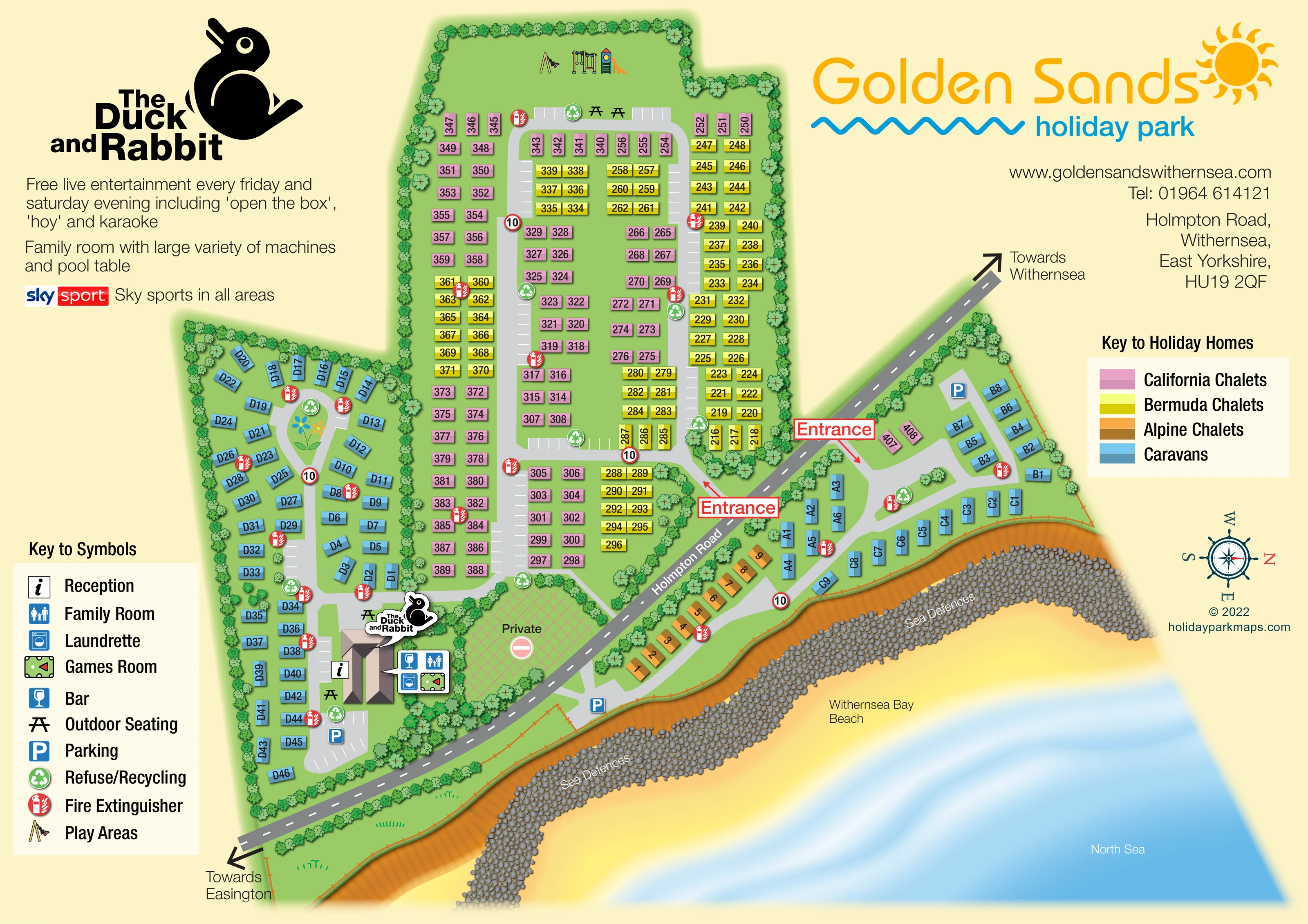
This illustrated map of Golden Sands Holiday Park places its caravan and chalet accommodation in a clear coastal setting at Withernsea, East Yorkshire. Holmpton Road runs diagonally through the artwork, separating the larger inland accommodation areas from a smaller section beside Withernsea Bay Beach. The North Sea, sandy shore and prominently drawn rock sea defences make that relationship immediately visible.
The map uses four accommodation colours: pink for California chalets, yellow for Bermuda chalets, orange for Alpine chalets and blue for caravans. These colours help visitors distinguish the dense chalet rows from the more loosely arranged caravan areas without relying on unit numbers alone. Two entrance callouts, directional arrows towards Withernsea and Easington, and a nautical compass provide wider orientation.
The main reception and leisure building is highlighted with The Duck and Rabbit branding and a grouped facility callout. Separate keys explain accommodation types and visitor facilities, including parking, outdoor seating, play equipment, recycling and fire extinguisher points. This sample combines practical site navigation with a distinctive shoreline illustration and space for the park's own branding.
The single landscape plan is built around three accommodation areas. A tall inland block contains closely arranged California and Bermuda chalets, served by a long grey road loop with connecting drives and marked parking bays. At its upper end, an open green area contains illustrated play equipment and picnic-table symbols. To the left, blue caravans follow a more irregular loop around planted islands, including a small decorative flower motif.
The main building sits near the lower end of this western caravan area. Reception is marked on its approach side, while a separate callout groups the bar, family room, laundrette and games room symbols. The Duck and Rabbit logo identifies the venue, with outdoor seating and parking shown nearby. Green refuse and recycling badges and red fire extinguisher badges recur throughout the accommodation sections.
Holmpton Road crosses the composition diagonally, with arrows towards Withernsea and Easington. Red entrance labels identify access to the inland and coastal sections. A cross-hatched private area is clearly distinguished beside the inland approach. Across the road, smaller caravan groups branch towards the shore, accompanied by a short orange Alpine chalet row and a small California chalet group.
The coastline forms a substantial foreground: a fenced green edge gives way to an orange-brown bank, a textured belt of grey sea-defence rocks, yellow beach and blue North Sea. A nautical compass shows north towards the right. Large branding and promotional panels balance the central plan, while separate facility and accommodation keys keep the dense drawing readable. The detail views enlarge these same keys and neighbouring map areas; they do not represent additional sections or alternative layouts.
KEEP EXPLORING
Chosen for shared landscapes, accommodation or facilities.
 Explore the map ↗
United Kingdom
Coastal park map with static-caravan rows, touring pitches, a camping field and two leisure clusters.
 Explore the map ↗
United Kingdom
Illustrated coastal holiday-home plan with dense alphanumeric plot labels, orange-roofed amenities, a numbered facility key and beach-side context.
 Explore the map ↗
United Kingdom
Coastal park plan with colour-coded pitches, named neighbourhoods and a Morecambe Bay walking route.
Features may come from the sample artwork, its key or published park information. Approximate numbers describe the drawing and may cover only part of a park. They are intended to help you compare map examples. Current facilities and booking information should be checked with the park.
LET’S MAP YOUR PARK
For a map quotation, find your park and draw a rough boundary around it. The area you select helps us work out the design time and price.
Draw your park for a quote ↗Or talk to our map designers
01751 473136