
Beach and sea
A broad sandy-coloured coastal strip, scattered outlined stones and layered blue surf run along the right-hand side of the plan.
ILLUSTRATED PARK MAP · P062
Ferry Rd, Golspie · United Kingdom
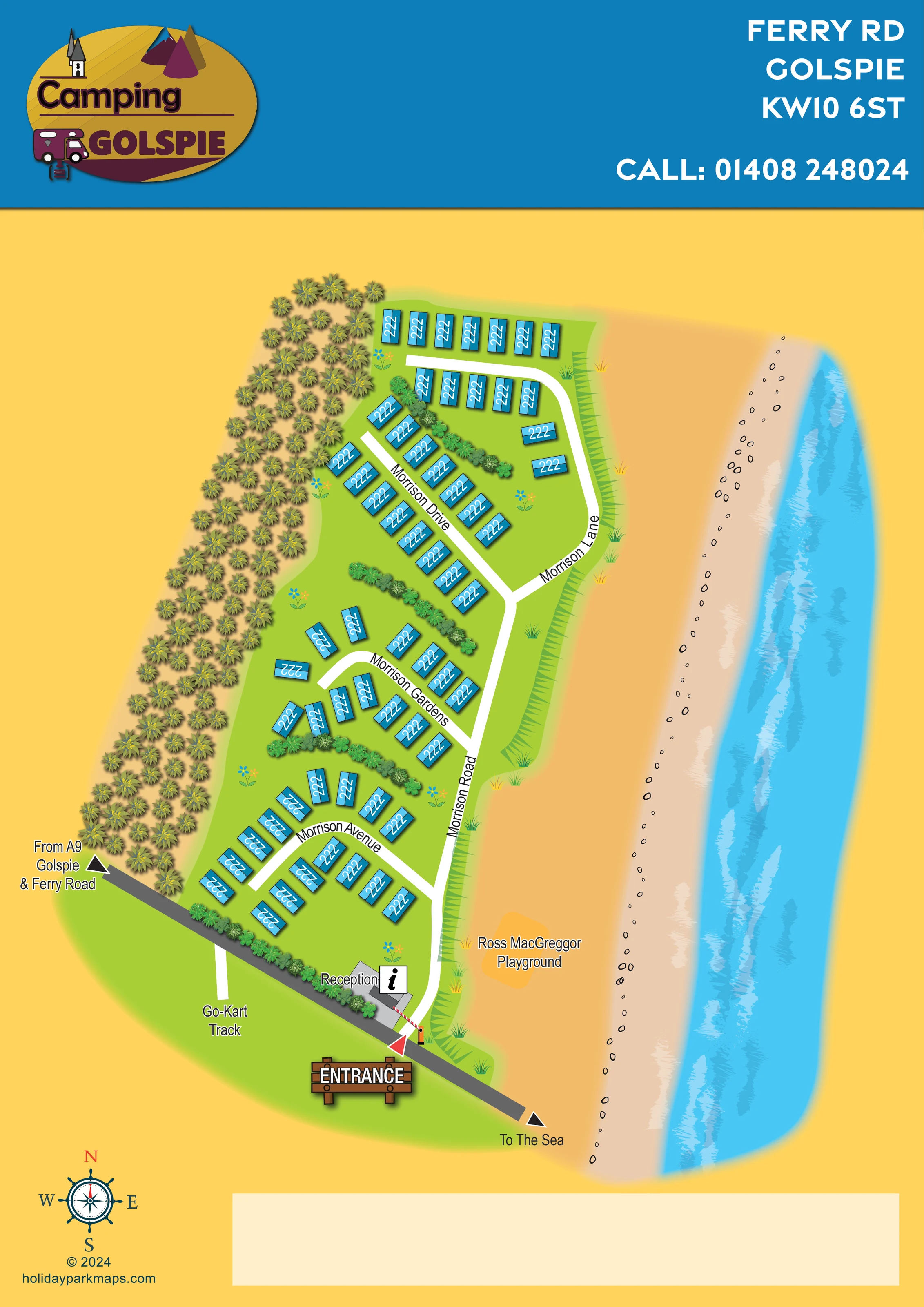 Enlarge the map ↗
A SENSE OF THE PLACE
Golspie Links Holiday Park occupies a coastal position beside Golspie Golf Club on the Moray Firth. The park offers privately owned static holiday homes with direct access to the shore.
Sea views, beach walks and the nearby village shape the location's appeal. The operator lists children's play areas, a games room, laundry and Wi-Fi among the facilities. The original artwork is titled Camping Golspie, but its phone number and Ferry Road location identify this park.
LOOK CLOSER
A broad sandy-coloured coastal strip, scattered outlined stones and layered blue surf run along the right-hand side of the plan.
A dense belt of stylised trees follows the left-hand boundary, contrasting with the open shoreline.
Curving shrub bands divide accommodation groups, with bright green lawns, decorative flowers and grass tufts throughout.
Labelled grey building beside the entrance, reinforced by a prominent information symbol.
Named orange-highlighted area on the shore side of the park, near the entrance end. Individual play equipment is not illustrated.
A labelled destination reached by a short white spur south of the approach road; no track circuit is drawn.
A wooden entrance sign, red triangular pointer and red-and-white barrier mark the junction between the approach road and internal road.
A dark grey diagonal approach road enters from the lower left, with an arrow and text identifying the external approach.
Labelled grey building beside the entrance, reinforced by a prominent information symbol.
Named orange-highlighted area on the shore side of the park, near the entrance end. Individual play equipment is not illustrated.
A labelled destination reached by a short white spur south of the approach road; no track circuit is drawn.
A wooden entrance sign, red triangular pointer and red-and-white barrier mark the junction between the approach road and internal road.
A dark grey diagonal approach road enters from the lower left, with an arrow and text identifying the external approach.
The approach road continues past the entrance towards the shore, ending in an arrow labelled To The Sea.
Morrison Road forms the shore-side spine, connecting Morrison Avenue, Morrison Gardens, Morrison Drive and Morrison Lane.
A broad sandy-coloured coastal strip, scattered outlined stones and layered blue surf run along the right-hand side of the plan.
A dense belt of stylised trees follows the left-hand boundary, contrasting with the open shoreline.
Curving shrub bands divide accommodation groups, with bright green lawns, decorative flowers and grass tufts throughout.
Listed in the park information but not located or labelled on this map.
Listed in the park information but not located or labelled on this map.
Mentioned in the park information; the artwork does not show coverage or a Wi-Fi facility.
READING THE MAP
This illustrated map of Golspie Links Holiday Park places the coastal setting at the centre of its design. Presented under the Camping Golspie name, the portrait artwork shows a long strip of static holiday homes between a dense tree-lined boundary and an expansive beach, with bright blue surf running down the right-hand side. The result gives visitors an immediate understanding of the park’s relationship with the shore.
White internal roads stand out against lime-green grounds, linking accommodation groups along Morrison Road and its named branches. At the lower end, a dark approach road leads from the A9, Golspie and Ferry Road to reception and the marked entrance, then continues towards the sea. The Ross MacGreggor Playground and a go-kart track destination add useful local landmarks.
A bold blue header, distinctive oval logo and nautical compass complete a sample suited to coastal holiday-home parks that need clear arrival information and a memorable sense of place.
The single portrait plan depicts an elongated park with approximately 60 static holiday-home symbols. Its inland edge is lined with closely packed stylised trees, while the opposite side opens onto a broad sandy-coloured shore. Outlined stones, pale foamy strokes and layered turquoise water make the coast a substantial part of the composition rather than a small background detail.
The accommodation layout is explained through a hierarchy of named white roads. Morrison Road runs along the shore-side edge from the entrance. Morrison Avenue curves through the lower group of homes, Morrison Gardens serves the central group, and Morrison Drive cuts diagonally through the upper section. Morrison Lane curves around the northern accommodation and connects back into the main route. Shrub bands separate these groups, while small flower motifs and grass tufts add visual texture to the green grounds.
Arrival is concentrated at the lower end of the map. A dark grey road approaches from the left with a label for the A9, Golspie and Ferry Road. Reception sits beside the internal junction, marked by an information symbol. A red-and-white barrier, red pointer and timber-style entrance sign make this junction conspicuous. The road continues towards an arrow labelled To The Sea. A short spur identifies the Go-Kart Track destination, and the Ross MacGreggor Playground is labelled on an orange patch beside the shore.
The blue header carries the Camping Golspie branding and contact details. Below the plan, a nautical compass and designer credit occupy the left corner, alongside a wide blank cream panel. Facilities are labelled directly rather than explained through a separate key.
KEEP EXPLORING
Chosen for shared landscapes, accommodation or facilities.
 Explore the map ↗
United Kingdom
Coastal park map with static-caravan rows, touring pitches, a camping field and two leisure clusters.
 Explore the map ↗
United Kingdom
Illustrated coastal holiday-home plan with dense alphanumeric plot labels, orange-roofed amenities, a numbered facility key and beach-side context.
 Explore the map ↗
United Kingdom
Coastal park plan with colour-coded pitches, named neighbourhoods and a Morecambe Bay walking route.
Features may come from the sample artwork, its key or published park information. Approximate numbers describe the drawing and may cover only part of a park. They are intended to help you compare map examples. Current facilities and booking information should be checked with the park.
LET’S MAP YOUR PARK
For a map quotation, find your park and draw a rough boundary around it. The area you select helps us work out the design time and price.
Draw your park for a quote ↗Or talk to our map designers
01751 473136