
Landscaped pitch boundaries and gardens
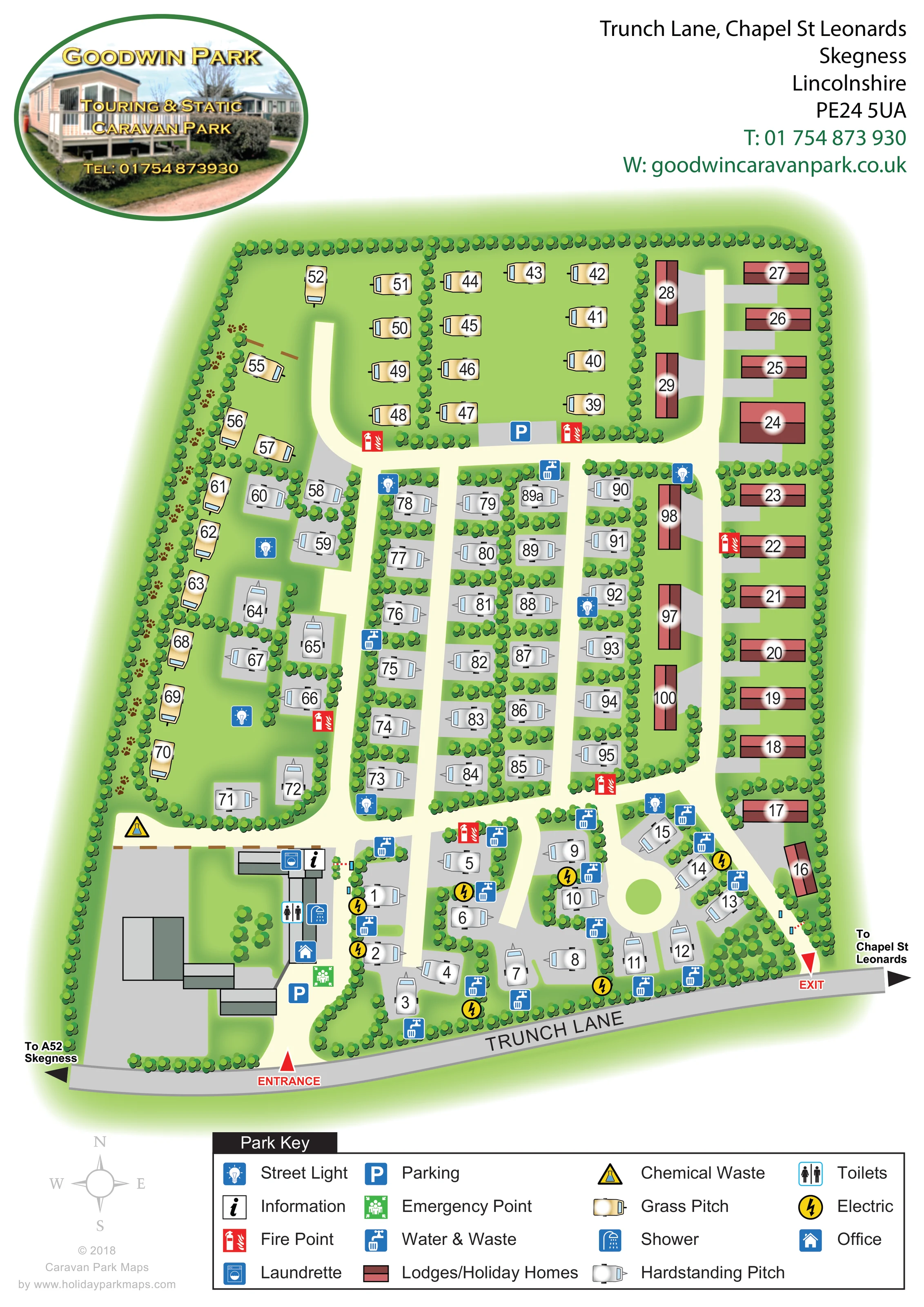
Dense rows of stylised shrubs enclose the park, separate pitch groups and frame individual plots. Small flower details line parts of the western boundary.
ILLUSTRATED PARK MAP · P474
Trunch Lane, Chapel St Leonards, Skegness, Lincolnshire · United Kingdom
 Enlarge the map ↗
A SENSE OF THE PLACE
Goodwin Park is a family-run holiday home park at Chapel St Leonards. Mature gardens give the site a village-like setting close to the beach and resort facilities.
Holiday home pitches include individual garden space and private parking, with controlled access at the entrance. The map explains the arrangement of homes and internal routes within this Lincolnshire coastal park.
LOOK CLOSER
Dense rows of stylised shrubs enclose the park, separate pitch groups and frame individual plots. Small flower details line parts of the western boundary.
An office symbol marks the southern end of the entrance-side service building.
An information symbol appears on the service building beside the main entrance approach.
The laundrette is marked at the northern end of the entrance-side service building.
Toilet and shower symbols identify facilities within the same entrance-side building group.
Blue parking symbols mark a space near the entrance buildings and a separate parking area beside the northern cross-route.
Repeated blue water-and-waste symbols are distributed through the touring areas, particularly around the southern pitches and central routes.
A yellow triangular chemical-waste symbol appears beside the service area, north-west of the entrance buildings.
An office symbol marks the southern end of the entrance-side service building.
An information symbol appears on the service building beside the main entrance approach.
The laundrette is marked at the northern end of the entrance-side service building.
Toilet and shower symbols identify facilities within the same entrance-side building group.
Blue parking symbols mark a space near the entrance buildings and a separate parking area beside the northern cross-route.
Repeated blue water-and-waste symbols are distributed through the touring areas, particularly around the southern pitches and central routes.
A yellow triangular chemical-waste symbol appears beside the service area, north-west of the entrance buildings.
Yellow lightning symbols identify electric points around the southern touring pitches.
Red fire-point symbols recur beside internal routes and accommodation groups.
A green emergency-point symbol is shown close to the office and entrance-side parking.
Blue light-bulb symbols mark street lights at intervals along internal routes.
Dense rows of stylised shrubs enclose the park, separate pitch groups and frame individual plots. Small flower details line parts of the western boundary.
Red labelled markers identify the entrance near the south-western service area and the exit at the south-eastern corner, both on Trunch Lane.
Pale cream lanes form a connected network between pitch rows, with a circular green island in the southern accommodation area.
Trunch Lane follows the bottom of the plan. Directional arrows point towards the A52 and Skegness to the left, and Chapel St Leonards to the right.
A dashed brown barrier-style line crosses the access to the grey service yard behind the entrance buildings.
READING THE MAP
This Goodwin Park map presents a landscaped touring and holiday-home park on Trunch Lane at Chapel St Leonards, Lincolnshire. Its overhead layout makes the relationship between individual pitches, internal lanes and entrance-side services easy to follow, while the illustrated planting gives a clear impression of the park’s garden-like character.
The map distinguishes grass touring pitches, grey hardstanding pitches and red lodge or holiday-home units. These groups occupy noticeably different parts of the site: grass pitches sit mainly towards the north and west, hardstandings form the central rows and southern clusters, and holiday homes line the eastern side. Separate entrance and exit markers connect the park to Trunch Lane, with arrows showing the directions towards the A52, Skegness and Chapel St Leonards.
An oval photographic badge introduces the park above the plan. Below it, large pitch numbers and familiar service symbols carry most of the practical information. The result is a useful sample for parks that need to explain a mixed accommodation layout, landscaped plot boundaries and shared facilities within one compact visitor map.
The single portrait plan shows an irregular enclosure bordered by thick bands of illustrated shrubs. Trunch Lane runs diagonally along the lower edge, with the entrance near the service buildings on the left and a separate exit at the right. Pale cream internal lanes branch through the park, linking a circular green island in the southern section to straight accommodation rows further north.
Three accommodation treatments explain the pitch mix. Cream caravan symbols sit directly on green ground for grass pitches; white-grey caravans stand on rectangular grey pads for hardstandings; and muted red rectangles identify lodges or holiday homes along the eastern boundary. Large black numbers, set against soft white highlights, remain prominent over each symbol. Hedge lines divide the central rows into small landscaped plots, while the western grass area has a looser arrangement and flower details along its outer edge.
The entrance-side building group carries office, information, laundrette, toilet and shower symbols. Nearby are parking, an emergency point and a chemical-waste point. Further parking appears beside the northern cross-route. Water-and-waste points, fire points and street lights recur around the accommodation areas, while yellow electric symbols are concentrated in the southern touring section. Grey aprons connect the eastern holiday homes to their adjoining lane.
The page combines a photographic park badge and contact block above the illustration with a large four-column Park Key below it. A pale compass sits beside the legend. Blue service icons, red fire symbols and yellow utility markers provide a consistent visual language across the plan and key. The detail views enlarge this same footer legend rather than presenting additional park sections.
KEEP EXPLORING
Chosen for shared landscapes, accommodation or facilities.
 Explore the map ↗
United Kingdom
A wooded Allerton park plan with colour-coded neighbourhoods, touring pitches and a central facilities hub.
 Explore the map ↗
United Kingdom
A wooded, mixed-accommodation park plan with winding lanes, a pool, camping areas and a clear facility key.
 Explore the map ↗
United Kingdom
Woodland-framed Barnsoul map with mixed accommodation, shared facilities and paw-marked walking routes.
Features may come from the sample artwork, its key or published park information. Approximate numbers describe the drawing and may cover only part of a park. They are intended to help you compare map examples. Current facilities and booking information should be checked with the park.
TAKE A CLOSER LOOK
View the illustrated map in detail or choose a file to download. These are sample maps; contact the park for current visitor information.

LET’S MAP YOUR PARK
For a map quotation, find your park and draw a rough boundary around it. The area you select helps us work out the design time and price.
Draw your park for a quote ↗Or talk to our map designers
01751 473136