
The North Sea
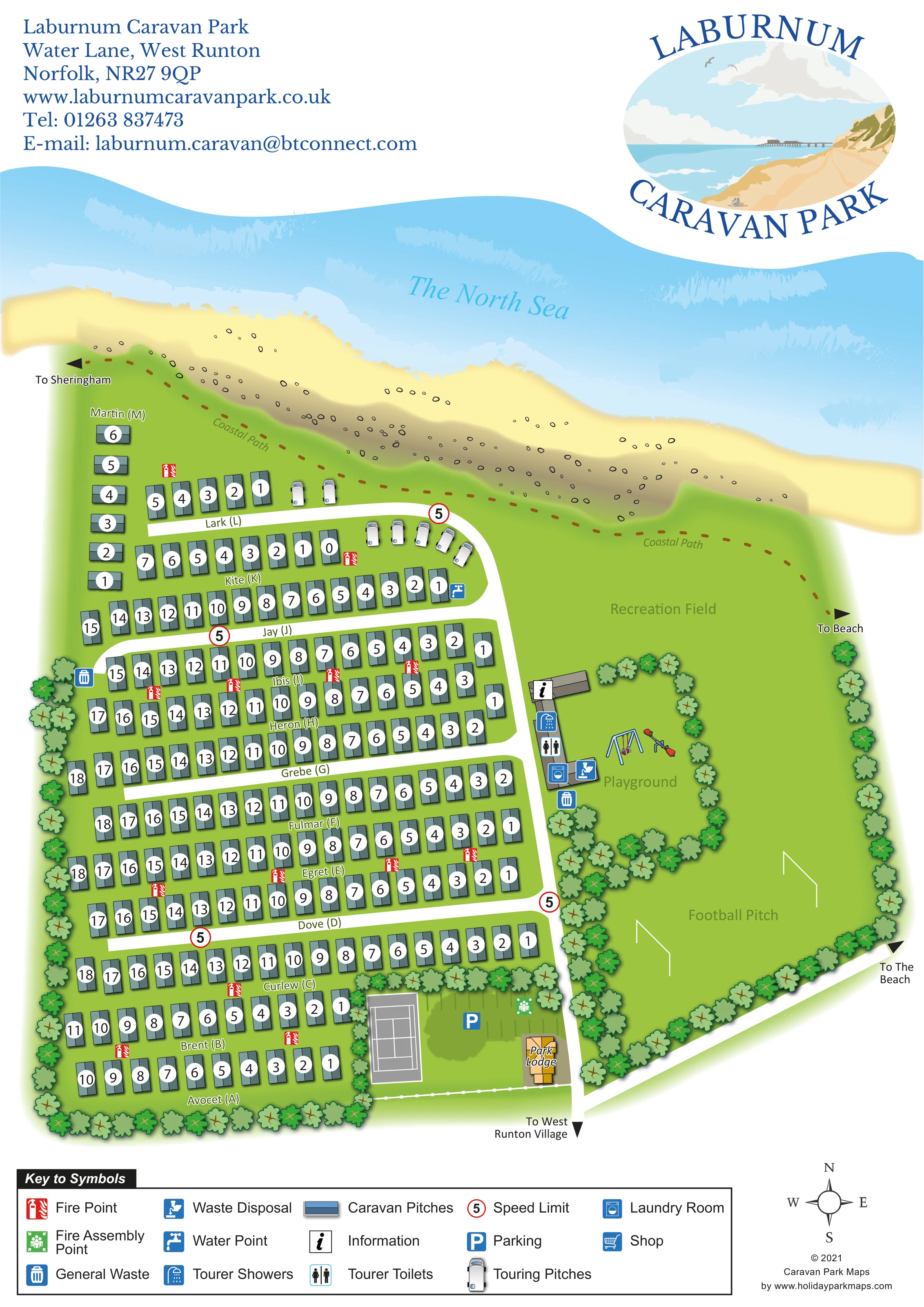
Named sea occupies a broad illustrated band across the top of the plan.
ILLUSTRATED PARK MAP · P515
Laburnum Caravan Park, Water Lane, West Runton, Norfolk · United Kingdom
 Enlarge the map ↗
A SENSE OF THE PLACE
Laburnum Caravan Park is a family-owned coastal park at West Runton in Norfolk. Its position overlooks the beach, making the shoreline central to the park's setting.
The map provides an overview of the caravan layout and internal access routes. It helps visitors understand the site before spending time in West Runton and exploring the surrounding North Norfolk coast.
LOOK CLOSER
Named sea occupies a broad illustrated band across the top of the plan.
A pale sandy shoreline with scattered stones separates the sea from the green park edge.
Stylised trees frame the western and southern boundaries, surround the playground and separate the football area from the accommodation.
A brown dashed route follows the northern boundary, with directions towards Sheringham and the beach.
The main internal road continues out of the southern edge towards West Runton Village.
Beach directions appear at the eastern end of the coastal path and on the separate diagonal route along the south-eastern boundary.
A substantial open green area occupies the eastern side of the site beside the coast.
The lower part of the eastern recreation space is labelled Football Pitch and illustrated with two goal frames.
Named sea occupies a broad illustrated band across the top of the plan.
A pale sandy shoreline with scattered stones separates the sea from the green park edge.
A brown dashed route follows the northern boundary, with directions towards Sheringham and the beach.
The main internal road continues out of the southern edge towards West Runton Village.
Beach directions appear at the eastern end of the coastal path and on the separate diagonal route along the south-eastern boundary.
A substantial open green area occupies the eastern side of the site beside the coast.
The lower part of the eastern recreation space is labelled Football Pitch and illustrated with two goal frames.
A tree-framed playground with illustrated swings and a seesaw sits beside the central amenities building.
An unlabelled grey court with tennis-style white markings is depicted beside the southern parking area.
An information symbol marks the northern end of the central amenities building.
Separate toilet and shower symbols are placed on the central amenities building beside the playground.
A washing-machine symbol identifies the laundry within the central amenities cluster.
A blue tap symbol appears at the eastern end of an upper caravan row.
General-waste bins are marked beside the western rows and central amenities; a separate waste-disposal symbol appears beside the amenities building.
Repeated red fire-point symbols are distributed among the accommodation rows.
A green assembly-point symbol is shown near the southern parking and Park Lodge area.
A blue parking symbol marks an open area near the southern entrance, beside the court and Park Lodge.
A yellow-roofed building labelled Park Lodge stands beside the southern access road; its use is not specified.
Red-ringed signs bearing the numeral 5 recur at bends and junctions on the white internal roads.
Stylised trees frame the western and southern boundaries, surround the playground and separate the football area from the accommodation.
Shop appears in the symbol key, but no corresponding location is clearly identifiable on the main plan.
READING THE MAP
This illustrated map of Laburnum Caravan Park places its North Norfolk coastal setting at the centre of the design. The North Sea stretches across the upper part of the page, with a sandy, stony shoreline and a dashed coastal path running beside the park. Directions towards Sheringham, the beach and West Runton Village connect the site plan with its surroundings.
Most of the accommodation sits in orderly caravan rows on the western side, identified by bird names, letter references and clear pitch numbers. A small touring group occupies the northern road bend. To the east, the map opens out into a recreation field, playground and football pitch, giving visitors an immediate sense of the different parts of the site.
White internal roads, coloured facility symbols and a broad lower-page legend provide the practical navigation layer. The coastal logo, blue headings and illustrated landscape give the page a recognisable seaside character without obscuring the accommodation layout.
The plan is arranged with the sea at the top and the village approach at the bottom. Visitors following the southern entrance reach Park Lodge, a marked parking area and an adjacent court with tennis-style markings before continuing along the main internal road. A diagonal route follows the south-eastern boundary towards the beach, distinct from the dashed coastal path along the northern edge.
The caravan area occupies the western half of the site. Closely spaced blue-grey units sit in long numbered rows, with names including Avocet, Curlew, Egret and Heron. Letter references accompany the bird names, making the rows easier to distinguish within the repeated grid. White cross-lanes feed from the eastern road spine, which bends around a small group of touring caravans near the coast. Red fire-point symbols are distributed between the rows, and circular speed markers punctuate the road network.
A central amenities building forms a useful landmark between accommodation and recreation space. Its symbols identify information, tourer toilets, showers and laundry, with waste facilities nearby. The playground immediately beside it is illustrated with swings and a seesaw, enclosed by a curved belt of trees. Beyond this cluster, the eastern grass area is labelled Recreation Field and Football Pitch, with goal frames showing the latter's position.
The page combines an overhead site plan with softly shaded trees, buildings and shoreline. A large contact block and oval coastal logo occupy the header, while the bottom legend explains the facility and accommodation symbols. The accompanying detail views enlarge this same legend; they are not separate park sections. A compass rose completes the orientation information.
KEEP EXPLORING
Chosen for shared landscapes, accommodation or facilities.
 Explore the map ↗
United Kingdom
Coastal park map with static-caravan rows, touring pitches, a camping field and two leisure clusters.
 Explore the map ↗
United Kingdom
Coastal park plan with colour-coded pitches, named neighbourhoods and a Morecambe Bay walking route.
 Explore the map ↗
United Kingdom
A colour-zoned coastal park map with touring areas, woodland trails, ponds and a leisure club.
Features may come from the sample artwork, its key or published park information. Approximate numbers describe the drawing and may cover only part of a park. They are intended to help you compare map examples. Current facilities and booking information should be checked with the park.
TAKE A CLOSER LOOK
View the illustrated map in detail or choose a file to download. These are sample maps; contact the park for current visitor information.


LET’S MAP YOUR PARK
For a map quotation, find your park and draw a rough boundary around it. The area you select helps us work out the design time and price.
Draw your park for a quote ↗Or talk to our map designers
01751 473136