
Golf landscape
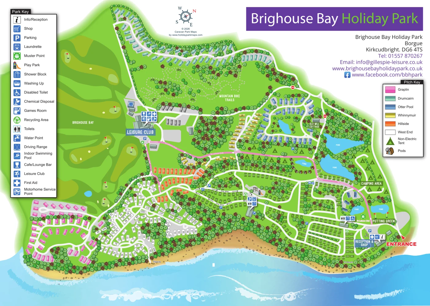
Broad fairways, greens, flags and small pale bunker-like shapes occupy the left side of the artwork.
ILLUSTRATED PARK MAP · P037
Brighouse Bay Holiday Park, Borgue, Kirkcudbright · United Kingdom
 Enlarge the map ↗
A SENSE OF THE PLACE
Brighouse Bay Holiday Park occupies a coastal setting near Borgue in Dumfries and Galloway. The family-owned park offers self-catering holidays, touring and camping, as well as caravan and lodge ownership.
Tree lines, stone dykes and planted areas divide the grounds, giving the park a countryside feel beside the bay. A leisure club and lounge bar provide a focus for time on site, with the surrounding coastline offering further opportunities to explore.
LOOK CLOSER
Broad fairways, greens, flags and small pale bunker-like shapes occupy the left side of the artwork.
The bay is illustrated with layered blue water, breaking-wave textures and a sandy, stone-dotted shoreline.
Several irregular blue ponds sit among the eastern accommodation, pods, camping and putting-green areas.
Dense tree belts divide neighbourhoods, frame the shoreline and roads, and surround the mountain bike trail area.
Reception and the shop form a labelled arrival cluster beside the main entrance at the lower right.
A clearly labelled leisure-club building cluster sits on the left side of the accommodation plan.
The swimming-pool symbol is placed at the leisure-club cluster and identified as indoor swimming in the Park Key.
A café/lounge-bar symbol appears at the leisure-club buildings.
Reception and the shop form a labelled arrival cluster beside the main entrance at the lower right.
A clearly labelled leisure-club building cluster sits on the left side of the accommodation plan.
The swimming-pool symbol is placed at the leisure-club cluster and identified as indoor swimming in the Park Key.
A café/lounge-bar symbol appears at the leisure-club buildings.
The games-room symbol is included in the leisure-club facility cluster.
A playground illustration sits beside the central touring roads and amenity buildings.
A flag-marked green is labelled beside the entrance-end ponds and reception approach.
A driving-range symbol is positioned near the leisure-club approach on the golf side of the plan.
Broad fairways, greens, flags and small pale bunker-like shapes occupy the left side of the artwork.
A large labelled woodland recreation area contains dotted winding trails and small cyclist illustrations.
Parking symbols identify spaces near reception, the leisure club and the eastern touring area.
Toilet, shower and washing-up symbols identify shared amenity provision around the touring and camping areas.
Wheelchair toilet symbols appear at mapped amenity clusters; the key labels these as disabled toilets.
Laundrette symbols appear at reception and at a central amenity cluster.
Chemical-disposal symbols are included at amenity facilities serving the touring areas.
A motorhome-service symbol appears in the leisure-club facility cluster.
Tap symbols mark water points distributed among accommodation and touring areas.
Green recycling symbols identify collection locations within the grounds.
First-aid symbols appear at reception and at the leisure-club cluster.
Green muster-point symbols are placed at several locations, including the entrance end and leisure-club area.
A prominent red label and arrow identify the main entrance beside reception.
A pink highlighted connection, repeatedly labelled 'To Leisure Club', crosses the park from the entrance side towards the leisure facilities.
Black directional arrows and 'One Way' labels indicate circulation on selected central roads; no-entry symbols appear on other road sections.
A 'To Beach' label identifies a shoreline connection near the lower-right touring pitches.
A slipway is labelled where a route meets the shore below the western accommodation areas.
The bay is illustrated with layered blue water, breaking-wave textures and a sandy, stone-dotted shoreline.
Several irregular blue ponds sit among the eastern accommodation, pods, camping and putting-green areas.
Dense tree belts divide neighbourhoods, frame the shoreline and roads, and surround the mountain bike trail area.
Old Mill Cottage is explicitly named within the blue Otter Pool area.
A labelled camping area occupies the eastern edge, with further non-electric tent symbols scattered near ponds and the highlighted route.
Pod symbols appear in a pond-side group and in a separate group nearer the leisure club.
READING THE MAP
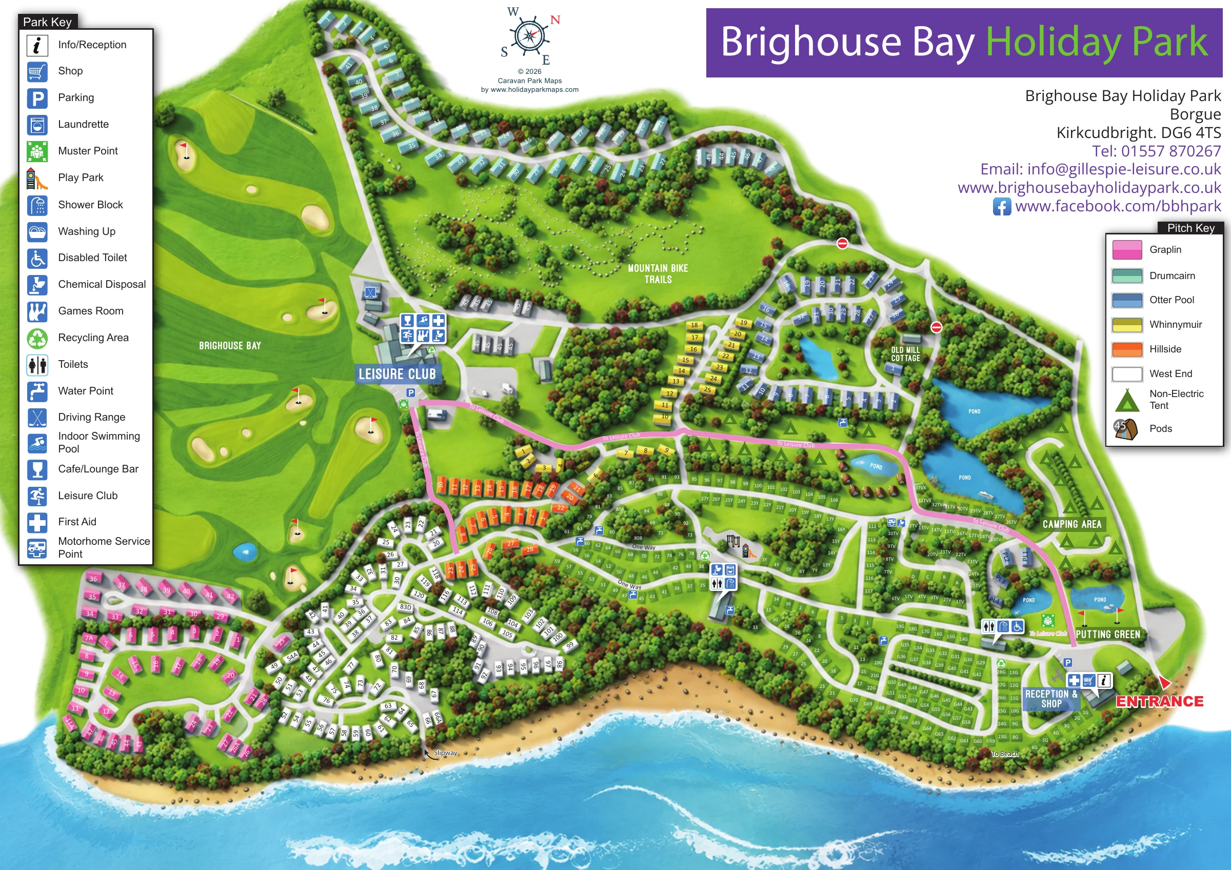
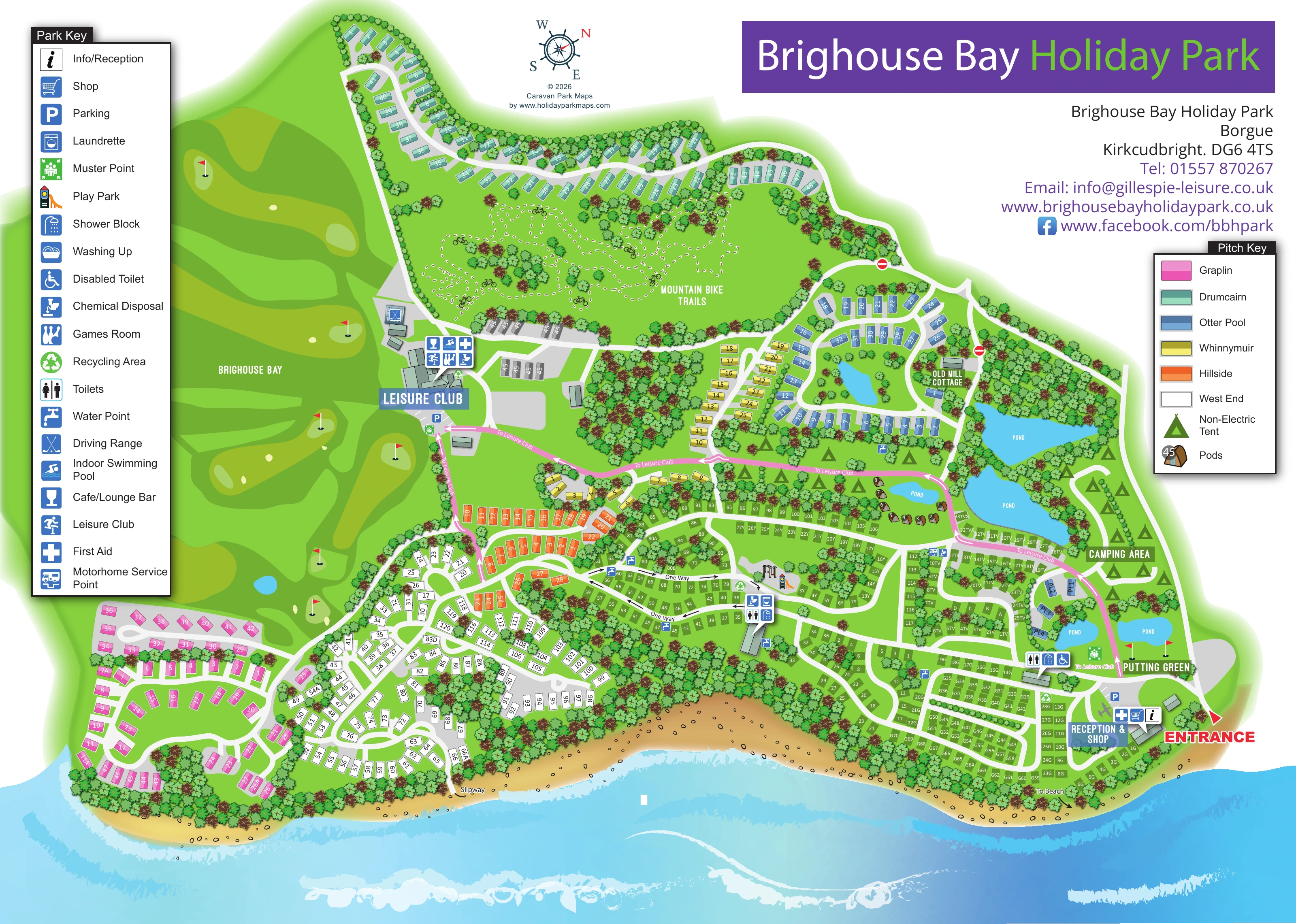
Brighouse Bay Holiday Park’s illustrated map brings together a broad coastal site, varied accommodation and a substantial collection of leisure facilities. The bay runs across the bottom of the artwork, anchoring the plan with a sandy shoreline, a labelled slipway and routes to the beach. Inland, tree belts, ponds and open recreation spaces give each part of the park a distinct setting.
The accommodation is organised into six named, colour-coded areas, alongside green touring pitches, non-electric camping, pods and Old Mill Cottage. White roads make the layout easy to follow, while a pink highlighted route links the entrance end of the park with the leisure club. Reception and the shop are clearly marked at arrival, and facility symbols identify practical stopping points throughout the grounds.
This is a useful sample for parks that need to explain more than a simple pitch grid. Mountain bike trails, golf features, a putting green and the leisure-club facilities are integrated into the same visitor-facing illustration, helping guests understand both where to go and how the different parts of the park fit together.
The plan spreads along the bay, with a sandy, rock-dotted shore and layered blue water forming its lower edge. A red entrance marker at the lower right leads directly to reception and the shop. From here, white internal roads divide into touring areas and accommodation neighbourhoods, with several loops, short branches and marked one-way sections. A pink route labelled 'To Leisure Club' crosses the park towards the leisure buildings on the left. Beach access and a slipway are labelled along the shoreline.
Six accommodation areas are distinguished by the Pitch Key: pink Graplin, teal Drumcairn, blue Otter Pool, yellow Whinnymuir, orange Hillside and white West End. Their numbered rectangular units contrast with the green numbered touring pitches concentrated through the middle and right of the plan. Tent symbols identify non-electric camping, including a labelled camping area along the eastern side. Pod illustrations appear beside a pond and in a separate group nearer the leisure club, while Old Mill Cottage is named within the blue accommodation area.
The leisure-club cluster carries symbols for indoor swimming, the café/lounge bar, games room, first aid and motorhome servicing. Other mapped facilities include a central play park, parking, laundrette, toilets, showers, washing-up provision, accessible toilets, chemical disposal, water points, recycling and muster points. Reception and a putting green occupy the arrival end of the park.
A large wooded mountain bike trail area fills the upper centre, using dotted winding trails and small cyclist illustrations. Golf fairways and flag-marked greens occupy the left side, with a driving-range symbol near the leisure buildings. Several bright blue ponds punctuate the accommodation and camping areas. Tree belts enclose neighbourhoods and soften the roads, while a compass rose, two boxed keys and the prominent purple title complete the page.
 Enlarge this map ↗
KEEP EXPLORING
Chosen for shared landscapes, accommodation or facilities.
 Explore the map ↗
United Kingdom
Trevornick’s colour-coded park map, with mixed accommodation, fishing ponds, golf and wooded trails.
 Explore the map ↗
United Kingdom
Woodland-framed Barnsoul map with mixed accommodation, shared facilities and paw-marked walking routes.
 Explore the map ↗
United Kingdom
Woodland holiday-park map with named accommodation areas, touring loops and illustrated recreation facilities.
Features may come from the sample artwork, its key or published park information. Approximate numbers describe the drawing and may cover only part of a park. They are intended to help you compare map examples. Current facilities and booking information should be checked with the park.
TAKE A CLOSER LOOK
View the illustrated map in detail or choose a file to download. These are sample maps; contact the park for current visitor information.



LET’S MAP YOUR PARK
For a map quotation, find your park and draw a rough boundary around it. The area you select helps us work out the design time and price.
Draw your park for a quote ↗Or talk to our map designers
01751 473136