
Tree-lined boundaries and hedged divisions
Dense stylised tree belts surround the grounds, while smaller repeated shrubs divide accommodation rows and frame buildings.
ILLUSTRATED PARK MAP · P584
Rocklands Lane, East Hill, Hastings, East Sussex · United Kingdom
 Enlarge the map ↗
A SENSE OF THE PLACE
Rocklands Holiday Park is based at Rocklands Lane, East Hill, Hastings, East Sussex. The site is set high on Hastings East Hill beside Hastings Country Park, with coast and sea views. Self-catering apartments provide sea views, parking, Wi-Fi and underfloor heating. Static caravans are privately owned; operator explicitly does not offer caravan holiday hire.
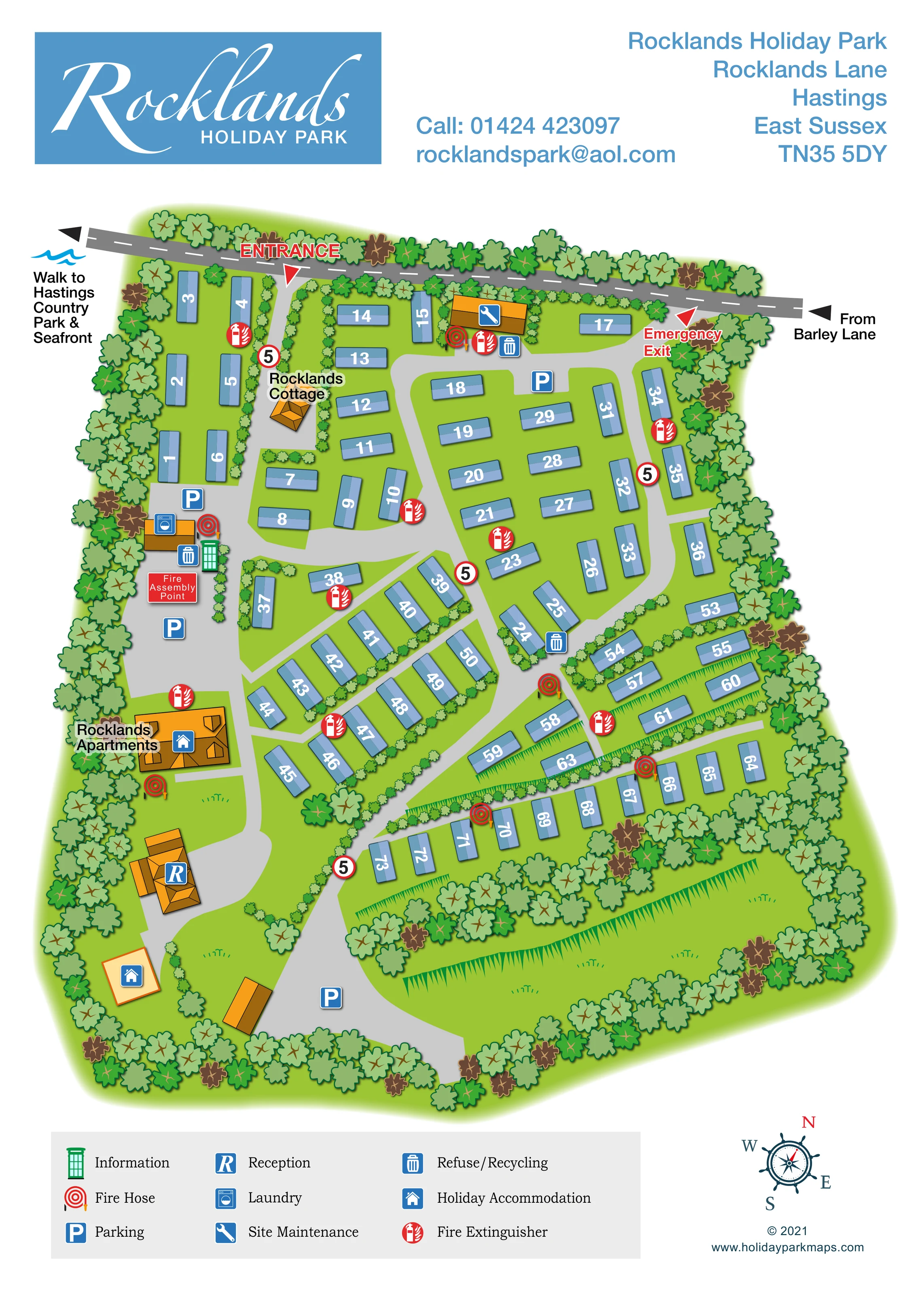
The map brings the site layout and its access routes together in one view, providing a reference for understanding the arrangement of the grounds.
LOOK CLOSER
Dense stylised tree belts surround the grounds, while smaller repeated shrubs divide accommodation rows and frame buildings.
Green triangular bank marks indicate changes in level through the lower-right accommodation area and the open grass below it.
An orange-roofed building beside the lower-left internal drive carries the blue reception symbol.
A green kiosk-style information symbol appears beside the laundry and fire assembly area.
The laundry is marked on a small building along the left side of the plan, adjoining a broad paved area.
Blue P symbols identify parking in several parts of the park, including the left-side service area, upper internal junction and bottom of the main drive.
Bin symbols mark grouped refuse/recycling locations beside the laundry, maintenance building and central accommodation lanes.
A blue spanner symbol identifies an orange-roofed maintenance building near the upper boundary.
An orange-roofed building beside the lower-left internal drive carries the blue reception symbol.
A green kiosk-style information symbol appears beside the laundry and fire assembly area.
The laundry is marked on a small building along the left side of the plan, adjoining a broad paved area.
Blue P symbols identify parking in several parts of the park, including the left-side service area, upper internal junction and bottom of the main drive.
Bin symbols mark grouped refuse/recycling locations beside the laundry, maintenance building and central accommodation lanes.
A blue spanner symbol identifies an orange-roofed maintenance building near the upper boundary.
Red hose-reel and extinguisher symbols are distributed through the accommodation areas and beside several buildings.
A red labelled assembly-point panel sits within the broad paved area beside the laundry and information point.
A large red entrance label and triangular marker identify the connection from the upper boundary road into the left-side internal drive.
A black arrow at the right end of the upper road is labelled 'From Barley Lane'.
A separately labelled red marker identifies an emergency exit at the upper-right connection to the boundary road.
A directional annotation at the upper-left edge points towards Hastings Country Park and the seafront; the onward walking route is not drawn in detail.
Broad grey drives curve through the park, with narrower connecting routes between the diagonal and terraced caravan rows. Repeated circular signs display the numeral 5.
Dense stylised tree belts surround the grounds, while smaller repeated shrubs divide accommodation rows and frame buildings.
Green triangular bank marks indicate changes in level through the lower-right accommodation area and the open grass below it.
A small orange-roofed building near the entrance is labelled Rocklands Cottage. Its use is not specified by the map.
The park is set high on Hastings East Hill beside Hastings Country Park, with coast and sea views. The map itself does not illustrate a sea panorama.
READING THE MAP
This illustrated map of Rocklands Holiday Park brings a compact, tree-lined site on Hastings East Hill into a single portrait view. Its main task is to make the relationship between numbered caravans, winding drives and larger buildings easy to understand, while retaining the character of the park's sloping grounds. Blue caravan symbols stand out against bright green lawns, and orange roofs distinguish landmarks such as Rocklands Apartments, Rocklands Cottage and reception.
The approach from Barley Lane runs across the top of the artwork, where the main entrance and a separate emergency exit are clearly labelled. A walking annotation points towards Hastings Country Park and the seafront, linking the site plan to its coastal surroundings without attempting to draw the wider landscape. Inside the park, parking, laundry, information, maintenance and refuse/recycling points are identified through a compact symbol system.
Hedged rows, dense boundary trees and illustrated banks give the map more structure than a simple plot diagram. A large branded header, bottom legend and nautical compass complete a practical visitor-facing design for a medium-sized caravan park with additional holiday accommodation.
The artwork uses a largely overhead plan, with modelled roof shapes providing a little depth to the principal buildings. A dark-grey road with a dashed centre line follows the upper boundary. The approach arrow from Barley Lane sits at its right end, while the left end carries a walking reference to Hastings Country Park and the seafront. Red triangular markers distinguish the main entrance from the emergency exit.
Within the grounds, a light-grey drive descends along the left side past the labelled Rocklands Cottage. It opens into a broad service and parking area containing the laundry, information point, refuse/recycling symbol and a prominently labelled fire assembly point. Further down, Rocklands Apartments and reception provide recognisable building landmarks. Another holiday-accommodation symbol appears near the lower-left boundary, and parking is also marked near the bottom of the drive.
The caravan layout changes across the plan. Short straight rows occupy the upper-left corner, while the upper centre and right contain groups served by curving drives. Diagonal ranks in the middle are separated by narrow routes and repeated shrub borders. Towards the lower right, longer stepped rows and triangular bank marks convey the terraced ground. An open grassy strip and substantial tree belt complete the lower edge.
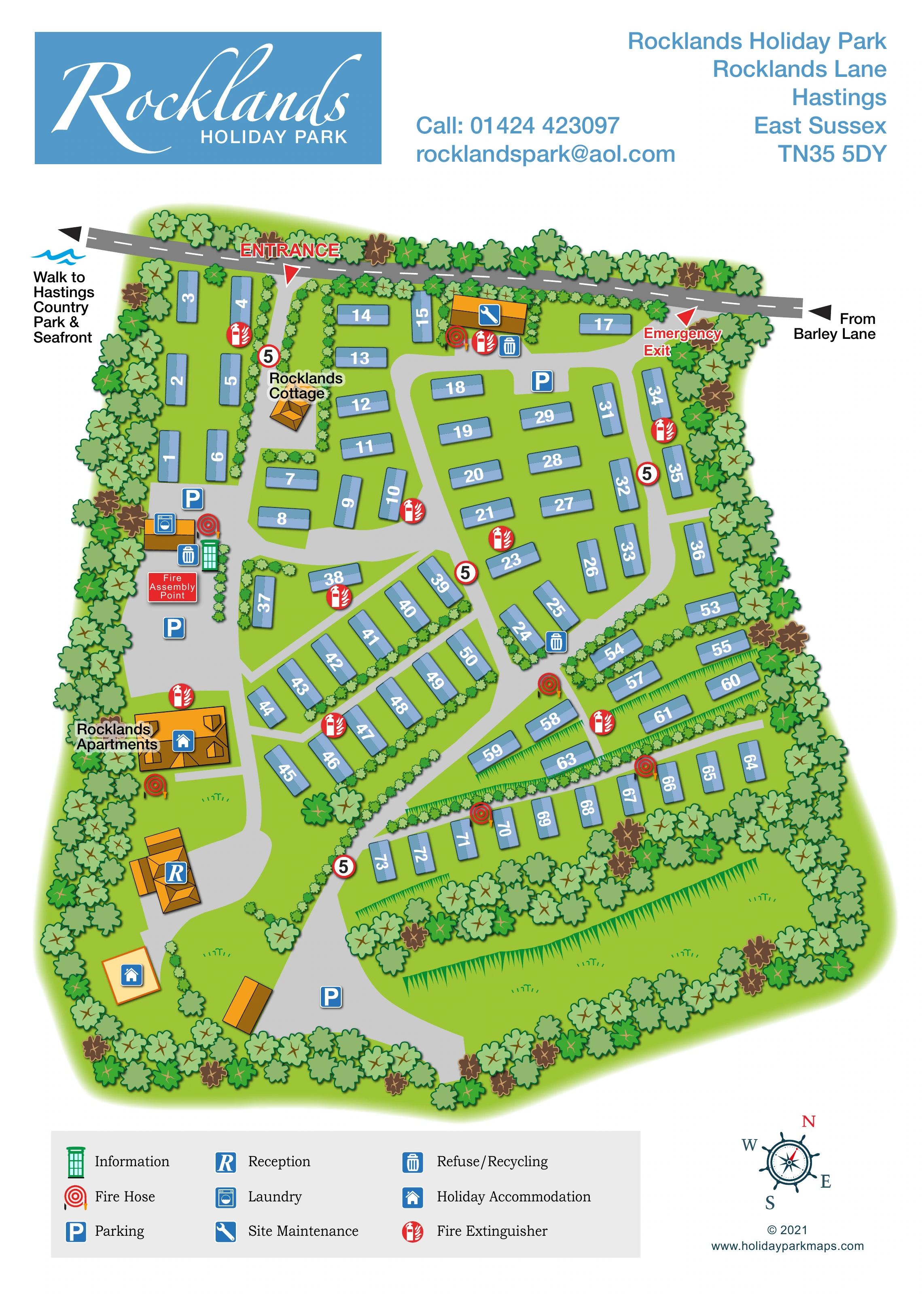
White numbers sit directly on the blue caravan shapes. Blue facility icons identify parking, maintenance and refuse/recycling locations, while red fire hoses and extinguishers remain visually distinct throughout the grounds. A nine-entry legend beneath the plan explains the symbol set. The white page reserves generous space above for the Rocklands logo and address details, with a ship's-wheel compass balancing the legend below. The enlarged detail views show portions of this same single-page design.
KEEP EXPLORING
Chosen for shared landscapes, accommodation or facilities.
 Explore the map ↗
United Kingdom
Coastal park map with static-caravan rows, touring pitches, a camping field and two leisure clusters.
 Explore the map ↗
United Kingdom
Illustrated coastal holiday-home plan with dense alphanumeric plot labels, orange-roofed amenities, a numbered facility key and beach-side context.
 Explore the map ↗
United Kingdom
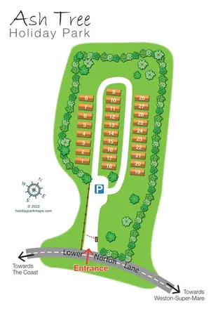
Tree-lined holiday-home park plan with a numbered road loop and clear Lower Norton Lane entrance.
Features may come from the sample artwork, its key or published park information. Approximate numbers describe the drawing and may cover only part of a park. They are intended to help you compare map examples. Current facilities and booking information should be checked with the park.
TAKE A CLOSER LOOK
View the illustrated map in detail or choose a file to download. These are sample maps; contact the park for current visitor information.


LET’S MAP YOUR PARK
For a map quotation, find your park and draw a rough boundary around it. The area you select helps us work out the design time and price.
Draw your park for a quote ↗Or talk to our map designers
01751 473136
 rocklands_large.png