
Hedged boundaries and trees
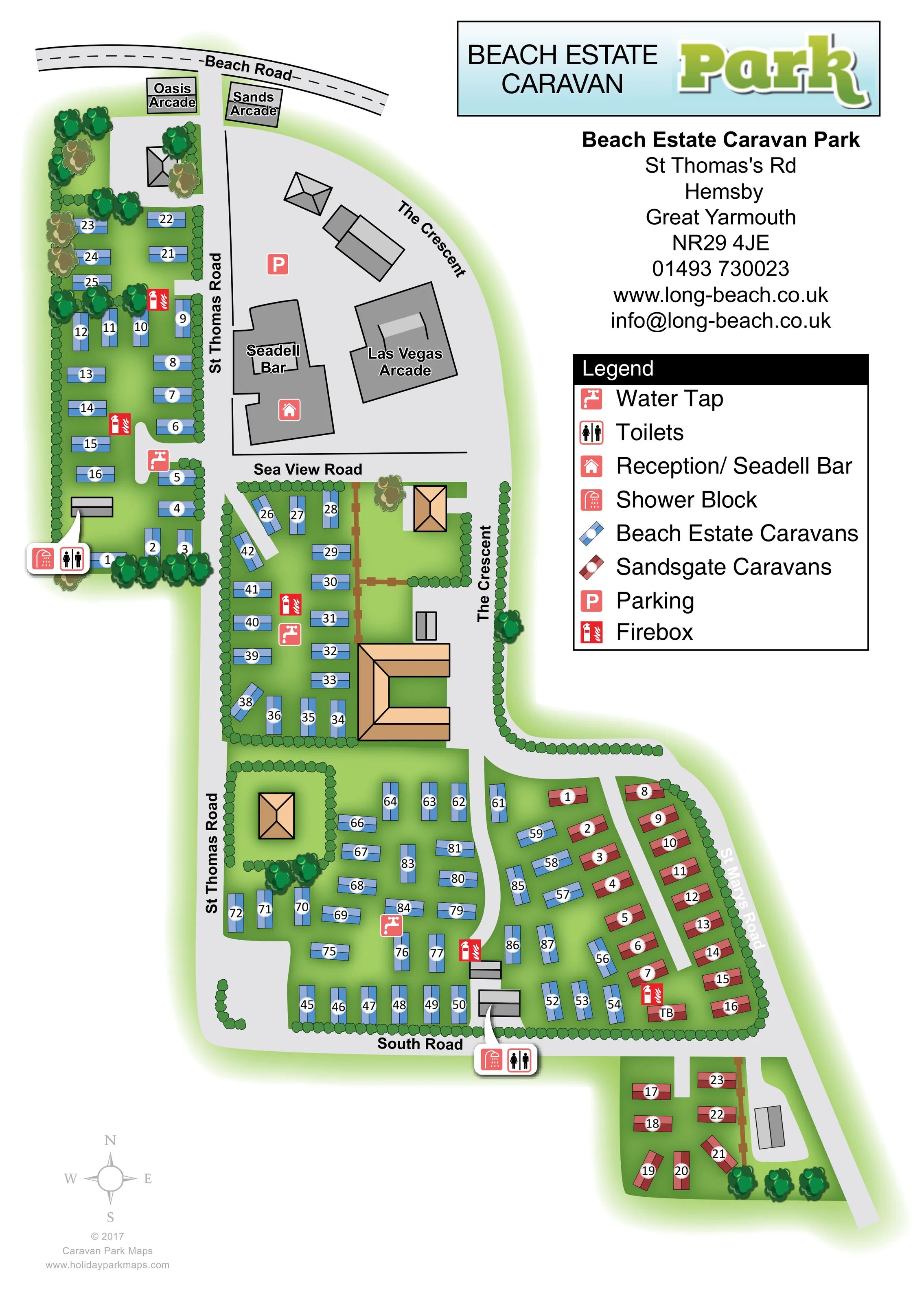
Continuous scalloped hedges enclose accommodation compartments and line roads, with clusters of stylised trees concentrated around edges and selected buildings.
ILLUSTRATED PARK MAP · P404
Beach Estate Caravan Park, St Thomas's Rd, Hemsby, Great Yarmouth · United Kingdom
 Enlarge the map ↗
A SENSE OF THE PLACE
Sandsgate Caravans (includes former Beach Estate) is based at Hemsby, Norfolk. Sandsgate is a static caravan ownership site close to Hemsby Gap beach.
The Sandsgate bar serves drinks and hot beverages near Beach Road. The park provides refurbished toilets/showers, free customer Wi-Fi and water, electricity and waste-water service to pitches.
LOOK CLOSER
Continuous scalloped hedges enclose accommodation compartments and line roads, with clusters of stylised trees concentrated around edges and selected buildings.
Caravans sit within bright green areas separated by roads and hedges; soft green shading gives the site a landscaped appearance.
A prominent grey building near the northern arrival area is labelled Seadell Bar and carries the reception symbol identified in the legend.
A parking symbol marks the broad grey forecourt near St Thomas Road, The Crescent and the bar.
Paired toilet and shower callouts identify facilities beside the western caravan strip and near South Road in the lower central part of the plan.
Coral tap symbols mark several shared water points among the caravan areas.
Bright red firebox symbols are distributed through the western, central and eastern accommodation groups.
Oasis Arcade and Sands Arcade are labelled beside Beach Road; the larger Las Vegas Arcade building stands beside The Crescent. These provide surrounding visitor landmarks rather than establishing park-operated facilities.
A prominent grey building near the northern arrival area is labelled Seadell Bar and carries the reception symbol identified in the legend.
A parking symbol marks the broad grey forecourt near St Thomas Road, The Crescent and the bar.
Paired toilet and shower callouts identify facilities beside the western caravan strip and near South Road in the lower central part of the plan.
Coral tap symbols mark several shared water points among the caravan areas.
Bright red firebox symbols are distributed through the western, central and eastern accommodation groups.
Oasis Arcade and Sands Arcade are labelled beside Beach Road; the larger Las Vegas Arcade building stands beside The Crescent. These provide surrounding visitor landmarks rather than establishing park-operated facilities.
Beach Road crosses the top of the artwork. St Thomas Road, The Crescent, Sea View Road, South Road and St Marys Road organise the site and its approaches.
Narrow grey spurs branch into the caravan groups, including a lane between the red Sandsgate rows and curved access through the lower blue caravan area.
Continuous scalloped hedges enclose accommodation compartments and line roads, with clusters of stylised trees concentrated around edges and selected buildings.
Caravans sit within bright green areas separated by roads and hedges; soft green shading gives the site a landscaped appearance.
READING THE MAP
This illustrated map brings together Beach Estate and Sandsgate caravans in Hemsby, Norfolk, using a clear colour distinction to explain a site spread across several connected roadside areas. Blue caravan symbols identify Beach Estate accommodation, while muted red symbols mark the Sandsgate rows and the smaller southern extension. The result is a practical overview of a coastal caravan setting without relying on a uniform grid.
Beach Road, St Thomas Road and The Crescent provide the main geographical framework. The map also includes the Seadell Bar and reception, parking, toilet and shower facilities, water taps and fireboxes. Nearby arcade names help visitors recognise the approach from Beach Road. Hedges and clusters of trees give each accommodation area a distinct outline, while numbered caravan symbols support more precise orientation.
The portrait composition reserves a generous right-hand panel for the park title, contact information and legend. It is a useful example for caravan sites that need to show adjoining named areas, surrounding landmarks and shared facilities within one coherent visitor map.
The plan begins at Beach Road, where Oasis Arcade and Sands Arcade flank the St Thomas Road approach. Below them, a narrow blue-caravan strip runs down the western side of the artwork. A broad grey area to its east contains the parking marker, the reception and Seadell Bar building, and the labelled Las Vegas Arcade beside The Crescent.
Sea View Road separates this northern arrival zone from a hedge-enclosed central caravan compartment. Here, blue units turn to follow the available space around tan-roofed buildings. Farther south, the site opens into a larger accommodation area between St Thomas Road and St Marys Road. Blue caravans occupy most of its western and central ground, while red Sandsgate units form rows beside an internal access lane on the eastern side. South Road runs beneath this main area, with a smaller red-caravan pocket continuing beyond it.
The legend explains both accommodation colours and six facility symbols. Water taps and fireboxes appear within the caravan groups, while paired toilet and shower symbols are presented in pointer callouts beside the western strip and near South Road. Number discs identify individual caravans without obscuring their blue or red classification.
The artwork combines flat road geometry with stylised roof shapes, scalloped hedges and layered tree canopies. Its pale-grey routes stand out against shaded green grounds, and the right-hand title, contact block and large legend balance the irregular site footprint. A small compass occupies the lower-left margin. The accompanying detail view enlarges the same legend and eastern caravan area; it is not a separate map or additional accommodation section.
KEEP EXPLORING
Chosen for shared landscapes, accommodation or facilities.
 Explore the map ↗
United Kingdom
Coastal park map with static-caravan rows, touring pitches, a camping field and two leisure clusters.
 Explore the map ↗
United Kingdom
Illustrated coastal holiday-home plan with dense alphanumeric plot labels, orange-roofed amenities, a numbered facility key and beach-side context.
 Explore the map ↗
United Kingdom
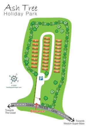
Tree-lined holiday-home park plan with a numbered road loop and clear Lower Norton Lane entrance.
Features may come from the sample artwork, its key or published park information. Approximate numbers describe the drawing and may cover only part of a park. They are intended to help you compare map examples. Current facilities and booking information should be checked with the park.
LET’S MAP YOUR PARK
For a map quotation, find your park and draw a rough boundary around it. The area you select helps us work out the design time and price.
Draw your park for a quote ↗Or talk to our map designers
01751 473136