
Sandy beach and sea
A broad yellow beach and softly shaded blue sea form the upper edge of the illustrated setting.
ILLUSTRATED PARK MAP · P287
Sea Palling, Norfolk · United Kingdom
 Enlarge the map ↗
A SENSE OF THE PLACE
Sandy Hills Caravan Park is based at Sea Palling, Norfolk. The small park lies among the sand dunes at Sea Palling with ramp access towards the beach. Hire caravans have a double and twin bedroom and accommodate up to four people.
Hire units include kitchen equipment, shower rooms and outdoor picnic benches.
LOOK CLOSER
A broad yellow beach and softly shaded blue sea form the upper edge of the illustrated setting.
Repeated grey rocks border a long grey strip between the beach and the grassy park surroundings.
Grass tufts, scattered trees and shrubs, and tan timber-style fences define the small park and its coastal surroundings.
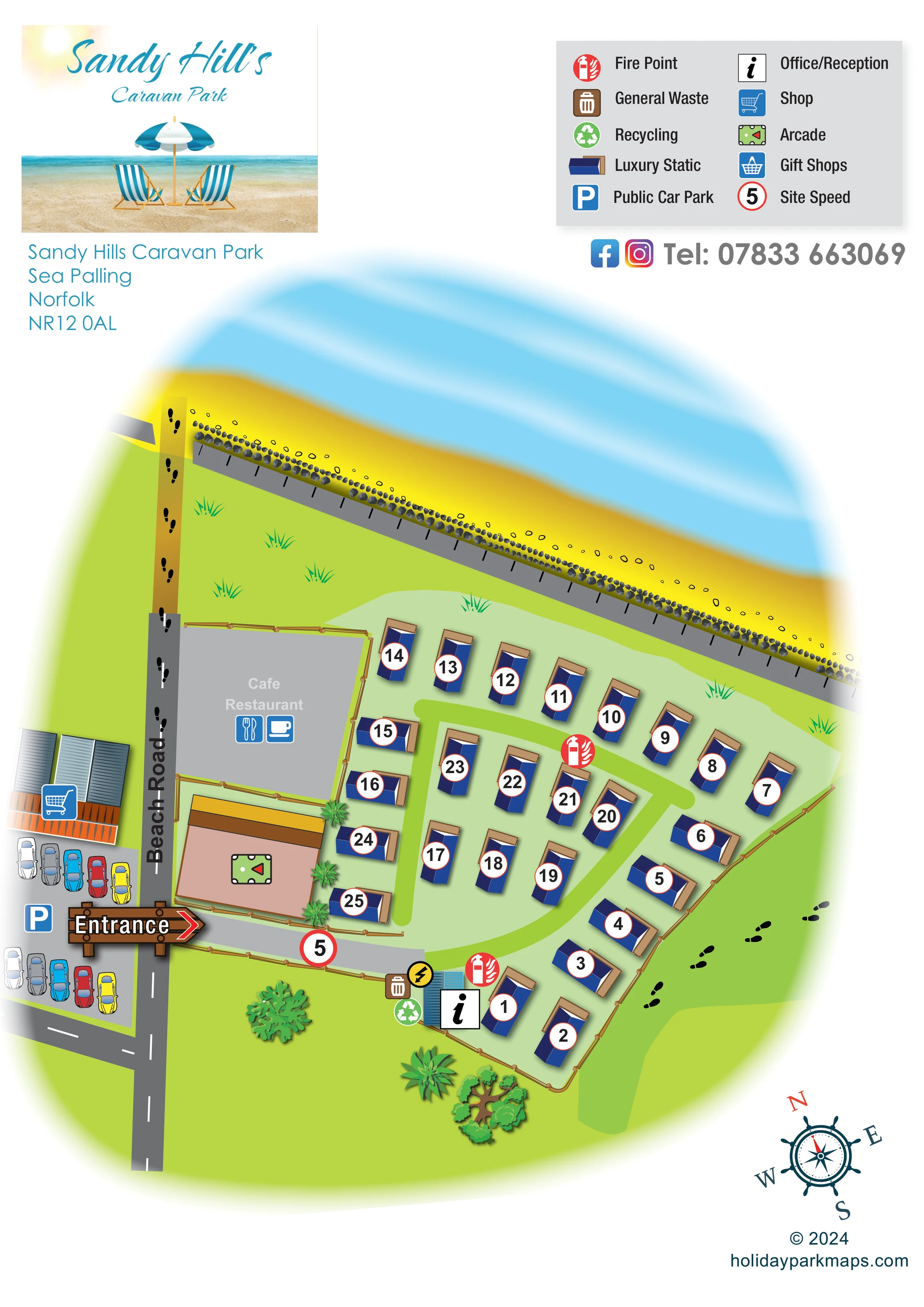
An information symbol identifies the small blue-roofed building beside the internal arrival lane.
A shopping-trolley symbol marks the commercial building across Beach Road from the caravan park.
A games-table-style symbol identifies the large building immediately beside the entrance, on the park side of Beach Road.
A grey enclosure beside Beach Road is labelled 'Cafe Restaurant' and carries cup and cutlery symbols.
A blue parking symbol and two illustrated rows of cars identify parking across Beach Road, opposite the entrance.
An information symbol identifies the small blue-roofed building beside the internal arrival lane.
A shopping-trolley symbol marks the commercial building across Beach Road from the caravan park.
A games-table-style symbol identifies the large building immediately beside the entrance, on the park side of Beach Road.
A grey enclosure beside Beach Road is labelled 'Cafe Restaurant' and carries cup and cutlery symbols.
A blue parking symbol and two illustrated rows of cars identify parking across Beach Road, opposite the entrance.
Red fire-point symbols appear beside reception and within the caravan area.
Brown waste and green recycling symbols are grouped next to the reception building.
Gift shops have a basket symbol in the key, but no corresponding position is clearly identifiable in the plan.
A prominent timber-style arrow points from Beach Road into the grey arrival lane.
The named road runs alongside the park and separates it from the illustrated shop and public parking.
Extracted artwork text names a 'Slipway to Beach'; the plan illustrates a footprint-marked continuation from Beach Road towards the sand.
Black footprints indicate the beachward route along Beach Road and a separate route outside the eastern caravan boundary.
A red-ringed '5' marker is placed on the arrival lane and identified as 'Site Speed' in the legend.
A broad yellow beach and softly shaded blue sea form the upper edge of the illustrated setting.
Repeated grey rocks border a long grey strip between the beach and the grassy park surroundings.
Grass tufts, scattered trees and shrubs, and tan timber-style fences define the small park and its coastal surroundings.
Operator information places the park among the sand dunes at Sea Palling and describes ramp access towards the beach.
READING THE MAP
This illustrated map of Sandy Hills Caravan Park places a small static-caravan site within its seaside setting at Sea Palling, Norfolk. The yellow beach and blue sea stretch across the upper part of the plan, while Beach Road provides a clear link between the park entrance, nearby shops, public parking and the route towards the sand.
Around 25 caravan symbols are arranged in a compact mix of curved perimeter rows and shorter internal groups. Dark-blue roofs and large numbered discs make the accommodation easy to distinguish from the surrounding greenery. Reception, fire points, waste and recycling are marked within the park, with an arcade and a labelled café/restaurant beside the approach.
The portrait page combines practical arrival information with a deliberately coastal identity. A beach-themed branding panel, turquoise lettering and a ship's-wheel compass complement the illustrated shoreline. Footprint symbols add another useful layer, separating walking routes from the grey road approach. This sample suits a small holiday park that needs visitors to understand both its accommodation layout and its relationship to neighbouring beachside amenities.
The plan shows a compact, roughly wedge-shaped caravan park beside Beach Road, with the beach and sea forming a strong diagonal across the upper page. A row of blue-roofed caravans follows the beach-facing edge, another bends around the eastern boundary, and shorter rows occupy the centre and the strip beside the arcade. Pale-green ground unifies the accommodation area, while brighter green circulation strips curve and branch between the units. Each caravan carries a large black number inside a white disc with a fine red outline.
Arrival is emphasised by a timber-style entrance arrow pointing across Beach Road into a light-grey lane. The lane passes the arcade and leads towards the small reception building. Waste, recycling and a fire-point symbol are grouped here; another fire point appears further into the caravan area. A red-ringed site-speed marker sits on the approach. Across Beach Road, the map depicts a shop and public parking with rows of coloured cars. The café/restaurant is labelled in a separate grey enclosure beside the arcade.
Black footprints trace the route towards the beach and a second route outside the eastern fence. The coast is drawn with golden sand, softly shaded blue water and a repeated line of grey rocks beside a grey shore-edge strip. Grass tufts and scattered trees provide a simple landscape framework without obscuring the accommodation.
The single portrait artwork places its beach-themed name panel and address at upper left and a two-column symbol key at upper right. Social-media icons and a telephone line sit below the key, while a nautical compass finishes the lower corner. The enlarged views show details of this same composition rather than separate map variants. Gift shops appear in the legend without a clearly located matching symbol on the plan.
KEEP EXPLORING
Chosen for shared landscapes, accommodation or facilities.
 Explore the map ↗
United Kingdom
Coastal park map with static-caravan rows, touring pitches, a camping field and two leisure clusters.
 Explore the map ↗
United Kingdom
Illustrated coastal holiday-home plan with dense alphanumeric plot labels, orange-roofed amenities, a numbered facility key and beach-side context.
 Explore the map ↗
United Kingdom
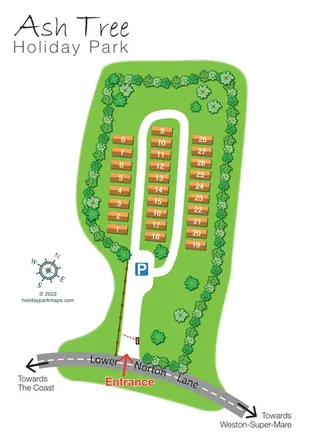
Tree-lined holiday-home park plan with a numbered road loop and clear Lower Norton Lane entrance.
Features may come from the sample artwork, its key or published park information. Approximate numbers describe the drawing and may cover only part of a park. They are intended to help you compare map examples. Current facilities and booking information should be checked with the park.
LET’S MAP YOUR PARK
For a map quotation, find your park and draw a rough boundary around it. The area you select helps us work out the design time and price.
Draw your park for a quote ↗Or talk to our map designers
01751 473136