
Coast and beach
Blue sea, a grey beach, scattered stones and projecting groynes form the entire left-hand setting of the plan.
ILLUSTRATED PARK MAP · P004
Aeron Coast Caravan Park, North Road, Aberaeron · United Kingdom
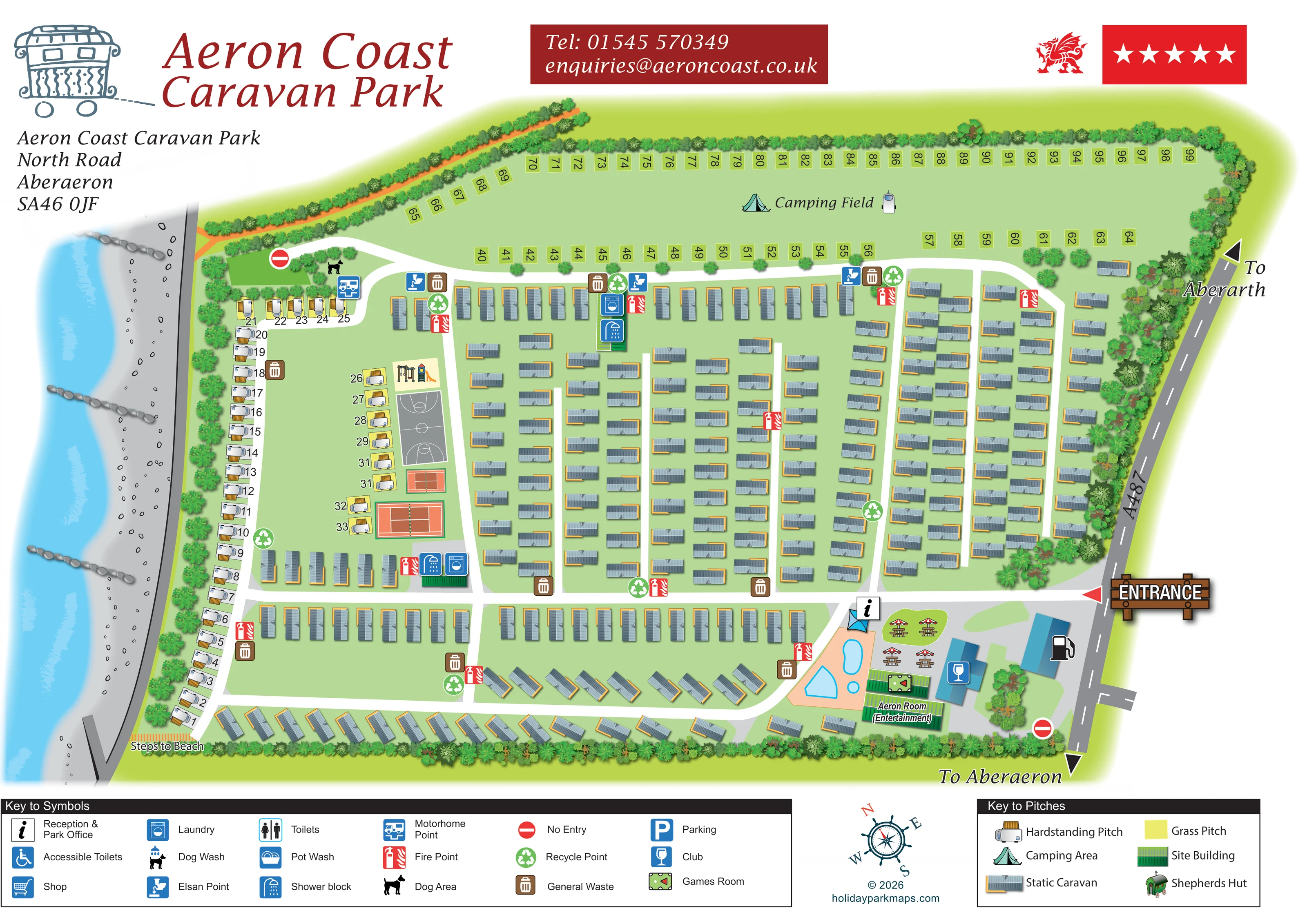 Enlarge the map ↗
A SENSE OF THE PLACE
Aeron Coast combines a coastal setting with the convenience of Aberaeron's harbour town. The park accommodates touring caravans, motorhomes and tents alongside privately owned static holiday homes.
Outdoor swimming pools, a clubhouse, games rooms, tennis and children's play facilities provide activities on site. The town and coast are central to its appeal, with beach access and a shop by the entrance. The privately owned static caravans are not offered as park rental accommodation.
LOOK CLOSER
Blue sea, a grey beach, scattered stones and projecting groynes form the entire left-hand setting of the plan.
Dense illustrated planting encloses most of the park, separates the coast-side pitches from the beach and softens the roadside edge.
Labelled beach access at the lower-left corner, beside the southern end of the touring pitches.
A prominent wooden sign and red arrow identify the entrance from the A487 on the right-hand side.
The roadside edge is labelled A487, with directions to Aberarth and Aberaeron.
White roads form a principal cross-park spine, branching lanes between caravan rows and connecting loops around the accommodation areas.
Red no-entry symbols appear at the north-western road end and near the south-eastern roadside boundary.
An information symbol identifies reception near the entrance and pool complex.
Blue sea, a grey beach, scattered stones and projecting groynes form the entire left-hand setting of the plan.
Labelled beach access at the lower-left corner, beside the southern end of the touring pitches.
A prominent wooden sign and red arrow identify the entrance from the A487 on the right-hand side.
The roadside edge is labelled A487, with directions to Aberarth and Aberaeron.
White roads form a principal cross-park spine, branching lanes between caravan rows and connecting loops around the accommodation areas.
Red no-entry symbols appear at the north-western road end and near the south-eastern roadside boundary.
An information symbol identifies reception near the entrance and pool complex.
Several blue pool shapes sit within a peach-coloured enclosure in the entrance-side leisure cluster.
The club symbol marks a blue-roofed building beside the pool and entertainment area.
A green games-table symbol identifies a building immediately beside the Aeron Room.
A green-roofed building in the south-east is explicitly labelled Aeron Room (Entertainment).
Umbrella-topped picnic tables are illustrated beside the entrance-side leisure buildings.
Two red tennis-court illustrations and a grey court with basketball-style markings form a western recreation strip.
Swings and a colourful slide are illustrated immediately above the sports courts.
Grouped shower and laundry symbols identify service buildings in the north-central area and beside the western recreation strip.
A motorhome point appears near the north-western touring pitches; Elsan symbols mark service locations along the northern internal road.
Brown waste-bin and green recycling symbols are distributed around the accommodation roads.
Repeated red fire-point symbols provide recognisable service landmarks throughout the plan.
A black dog symbol marks an area beside the north-western road and touring service point.
Dense illustrated planting encloses most of the park, separates the coast-side pitches from the beach and softens the roadside edge.
Published park information describes a shop by the entrance. The symbol key also includes Shop, but its basket symbol is not clearly placed on the plan.
The legend includes accessible toilets, toilets, pot wash, dog wash and parking; their individual positions are not clearly identifiable in this view.
A shepherd's hut is included in the accommodation key, but no corresponding hut location is clearly identifiable on the plan.
READING THE MAP
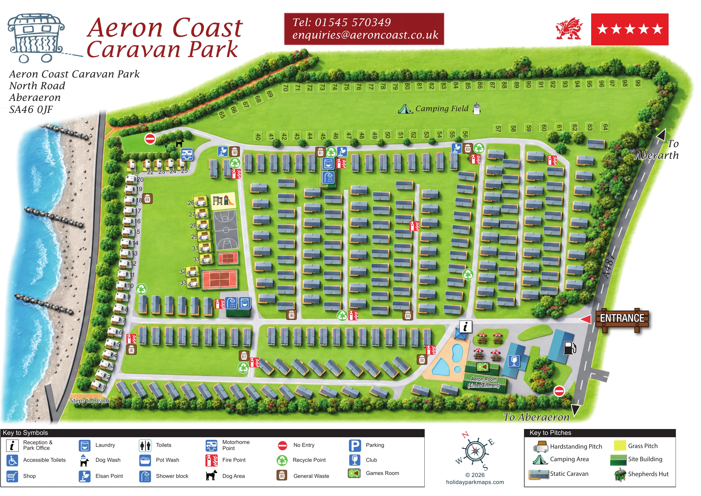
This illustrated map of Aeron Coast Caravan Park places its coastal setting at the heart of the visitor experience. The sea and beach run down one side of the artwork, while the A487 and directions to Aberaeron and Aberarth establish the road approach on the other. Between them, a clear network of white roads connects extensive static-caravan rows, beach-side touring pitches and a large northern camping field.
The design makes the park's different areas easy to distinguish without losing their relationship to the whole site. Numbered grass pitches frame the camping field, illustrated hardstandings follow the western boundary, and the leisure facilities form two recognisable clusters. Tennis courts, a multi-sport court and children's play equipment occupy the western side; pools, the club, games room and Aeron Room sit near the main entrance.
A detailed coastline, tree-lined boundaries and a nautical compass give the map a strong sense of place. Separate facility and pitch keys support practical orientation, while the large park title, Welsh dragon and prominent entrance sign make this a distinctive example of a coastal holiday-park map.
The single-page plan is organised around a strong east-to-west arrival road, entered from the A487 beside a large illustrated wooden entrance sign. Reception is marked close to the entrance, alongside an outdoor pool enclosure and a compact group of leisure buildings. The club and games room have recognisable pictograms, while the Aeron Room is labelled directly as an entertainment building. Umbrella-topped tables add a visual cue to the outdoor social space.
Most of the central and eastern site consists of static caravans arranged in repeated rows, separated by broad white lanes. Further rows follow the southern boundary, where several units are angled to fit the site's outline. Touring hardstandings occupy the western beach-side edge and a smaller strip beside the recreation area. Across the top, numbered grass pitches frame an open area labelled Camping Field rather than filling it with individual tent illustrations.
The western recreation strip includes two red tennis-court illustrations, a grey multi-sport court and children's play equipment. Shower and laundry symbols mark nearby service buildings and another group farther north. Elsan points, a motorhome point, waste and recycling points, and red fire-point symbols provide smaller landmarks around the road network. A dog-area symbol appears near the north-western touring area.
The beach is drawn with stones, groynes and a pale surf line, with Steps to Beach labelled at the lower-left corner. Tree and hedge illustrations enclose the remaining boundaries. Along the bottom, separate keys explain facilities and accommodation symbols, with a ship's-wheel compass between them. The legend enlargements show these same keys in greater detail; they are not separate park sections.
 Enlarge this map ↗
KEEP EXPLORING
Chosen for shared landscapes, accommodation or facilities.
 Explore the map ↗
United Kingdom
Colour-coded accommodation, central leisure facilities and coastal paths on an illustrated headland park map.
 Explore the map ↗
United Kingdom
A colour-zoned coastal park map with touring areas, woodland trails, ponds and a leisure club.
 Explore the map ↗
United Kingdom
Tree-framed mixed-accommodation park map with two entrances, touring loops and a clearly illustrated social hub.
Features may come from the sample artwork, its key or published park information. Approximate numbers describe the drawing and may cover only part of a park. They are intended to help you compare map examples. Current facilities and booking information should be checked with the park.
LET’S MAP YOUR PARK
For a map quotation, find your park and draw a rough boundary around it. The area you select helps us work out the design time and price.
Draw your park for a quote ↗Or talk to our map designers
01751 473136