
Woodland and open camping clearings
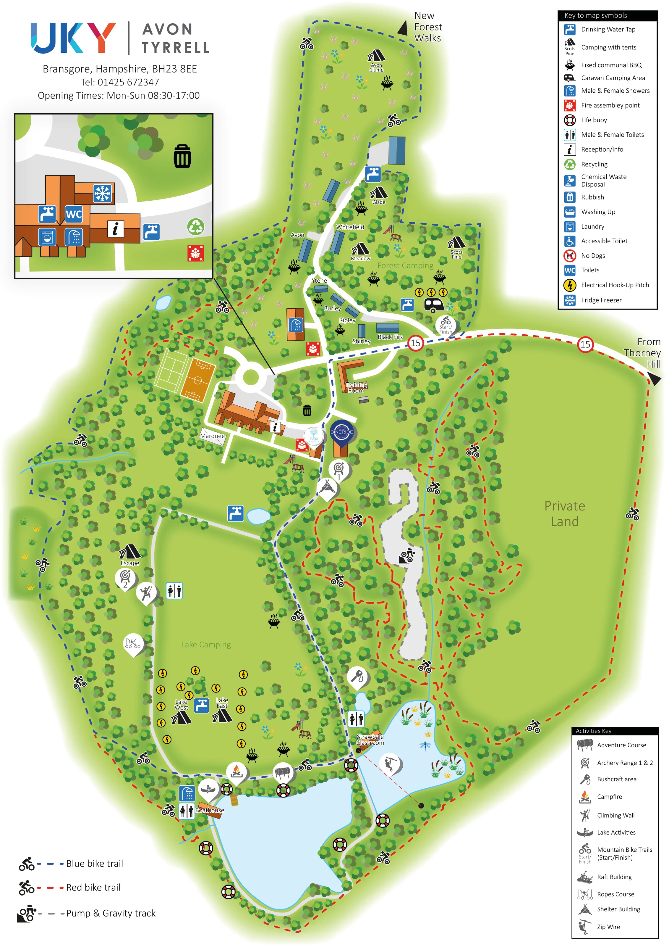
Dense clusters of stylised trees enclose the accommodation, activity spaces and cycle routes, contrasting with the broad open Lake Camping field.
ILLUSTRATED PARK MAP · P398
Bransgore, Hampshire · United Kingdom
 Enlarge the map ↗
A SENSE OF THE PLACE
Avon Tyrrell Outdoor Centre is based at Bransgore, Hampshire. The centre occupies 65 acres in the New Forest National Park. Six camping areas include electric and dog-friendly pitches; seven self-contained lodges sleep six, twelve or fourteen people.
Accessible Adventure breaks offer accommodation and activity programmes adapted to guests' needs. Facilities and activities include a treetop trail, bike hire and tracks, cafe and shop.
LOOK CLOSER
Dense clusters of stylised trees enclose the accommodation, activity spaces and cycle routes, contrasting with the broad open Lake Camping field.
A large southern lake and smaller eastern lake anchor the lower half of the plan. Small ponds and a narrow blue watercourse add detail elsewhere.
A large open area east of the activity woodland is explicitly labelled Private Land.
Information symbols mark the main building and the enlarged service-building inset.
A café badge appears beside the central building complex.
A BIKERIDE badge identifies a cycle-related building beside the café and central route.
Facilities are distributed between the northern accommodation cluster, the central service inset, the western activity area and the lakeside buildings.
Blue tap symbols identify water points around the camping areas and service buildings.
Information symbols mark the main building and the enlarged service-building inset.
A café badge appears beside the central building complex.
A BIKERIDE badge identifies a cycle-related building beside the café and central route.
Facilities are distributed between the northern accommodation cluster, the central service inset, the western activity area and the lakeside buildings.
Blue tap symbols identify water points around the camping areas and service buildings.
Yellow electrical symbols appear in the Lake Camping field and beside the northern caravan camping area.
Black barbecue pictograms are placed throughout the woodland accommodation areas and beside Lake Camping.
Both are identified in the enlarged service-building inset.
Waste symbols appear by the central buildings and in the inset, including a distinct green recycling symbol.
The key also includes washing up, chemical waste disposal and an accessible toilet. Their positions are not clearly established in this artwork.
A training room sits near the entrance road; the Strawbale Classroom is labelled beside the smaller eastern lake.
A marquee is labelled immediately south-west of the main building.
Two outlined sports courts sit north-west of the main building. Small illustrated slide-and-swing groups appear in several accommodation and central areas.
Numbered target symbols identify two separate archery locations, one near the central activity hub and one beside the western camping area.
Activity markers place the climbing wall and ropes course along the western side of the Lake Camping area.
An adventure-course marker sits near the northern shore of the main lake; a shelter-building marker appears beside the central route.
Bushcraft is marked beside the woodland route towards the smaller lake, while the campfire location is shown near the northern shore of the main lake.
Water-activity markers are clustered around the southern lakes. A zip-wire marker and dashed crossing line appear over the smaller eastern lake.
The boathouse is labelled on the north-western shore of the main lake, beside activity and washing-facility symbols.
Red assembly-point symbols appear around the main buildings and service area. Life-buoy symbols are distributed around both lakes.
Dense clusters of stylised trees enclose the accommodation, activity spaces and cycle routes, contrasting with the broad open Lake Camping field.
A large southern lake and smaller eastern lake anchor the lower half of the plan. Small ponds and a narrow blue watercourse add detail elsewhere.
A large open area east of the activity woodland is explicitly labelled Private Land.
A right-hand directional arrow leads onto the east–west entrance road. Two red-ringed 15 signs are depicted along this approach.
White routes connect the entrance, northern accommodation, central buildings and southern lakes, with a circular junction beside the main building.
Distinct dashed blue and red routes weave through the grounds, supported by bicycle pictograms and a start/finish marker near Forest Camping.
A grey track with dashed edging occupies a woodland corridor east of the central route.
A directional arrow at the northern end points towards New Forest Walks.
READING THE MAP
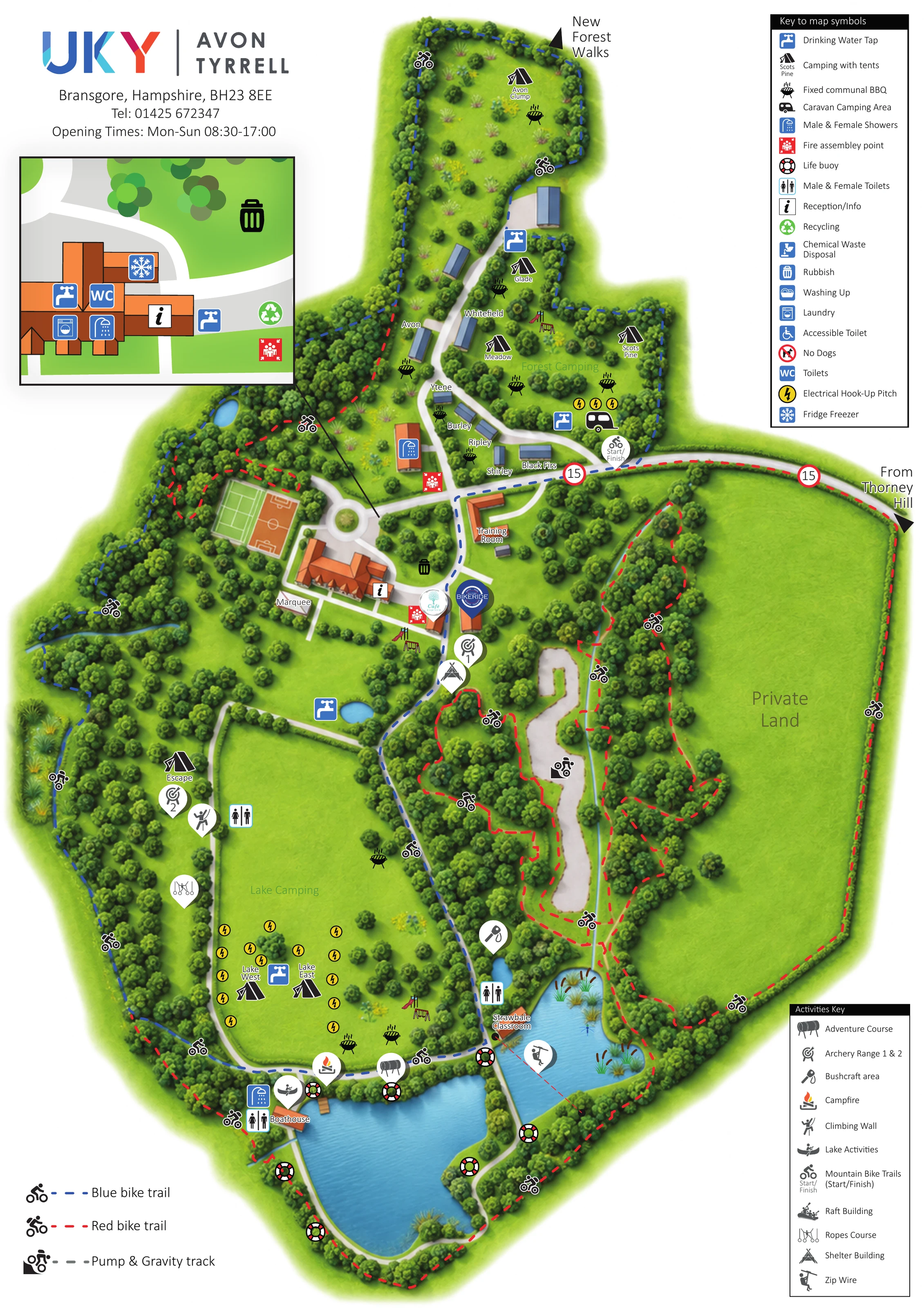
This illustrated map of Avon Tyrrell Outdoor Centre brings accommodation, woodland routes and outdoor activities together on one portrait-format plan. Set at Bransgore in Hampshire, the centre is presented as a landscape of tree-lined clearings, open camping ground and lakes, rather than a conventional grid of holiday pitches. Blue-roofed lodges sit beside the northern lane, while named tent-camping areas extend through the woods and towards the water.
The map gives particular prominence to movement around the grounds. Red and blue bike trails weave around the estate, a separate grey treatment identifies the pump and gravity track, and white roads connect the entrance, main buildings and lakeside facilities. Activity symbols locate archery, climbing, ropes, bushcraft and water-based activities alongside practical camping services.
A large inset makes the service-building cluster easier to read, while separate facility and activity keys keep the busy plan organised. The result is a useful sample for outdoor centres and woodland campsites that need to explain both where guests stay and how they explore a varied activity landscape.
The artwork follows the centre’s elongated grounds from the northern camping clearings to the lakes at the southern end. Arrival is indicated from Thorney Hill on the right, where a white entrance road runs towards the central junction. From here, one route serves the northern accommodation and another continues past the main buildings towards the water. A circular junction, sports courts, training room and marquee help define the central hub.
Blue-roofed lodges form a loose group along the northern lane. Around them, tent symbols identify named camping clearings including Glade, Meadow and Scots Pine. Farther south-west, the broad Lake Camping field contains Lake West and Lake East, with water and electrical hook-up symbols. A caravan camping area is marked near Forest Camping. These are area-based accommodation illustrations rather than a numbered pitch plan.
The lower portion is especially activity-rich. Archery, climbing and ropes-course markers occupy the western side, while the boathouse, campfire and adventure course sit near the main lake. The smaller eastern lake is accompanied by the Strawbale Classroom and a zip-wire marker with a dashed crossing line. Life-buoy symbols punctuate the shorelines.
Red and blue dashed cycle trails run through the woodland and around the estate, with a grey pump and gravity track in the eastern interior. A northern arrow points towards New Forest walks. Service symbols identify toilets, showers, drinking water, communal barbecues, waste points and assembly locations. The framed upper-left inset enlarges a service-building cluster, including laundry and fridge-freezer symbols. Two right-hand legends and a lower-left cycling key complete the composition. The accompanying detail view enlarges part of this same artwork rather than showing an additional site or map variant.
 Enlarge this map ↗
KEEP EXPLORING
Chosen for shared landscapes, accommodation or facilities.
 Explore the map ↗
United Kingdom
A lakeside holiday-park and fishery map with numbered accommodation, fishing positions and clearly grouped visitor services.
 Explore the map ↗
United Kingdom
Woodland park map with mixed pitches, bell tents, lodges and a fishing lake.
 Explore the map ↗
United Kingdom
Illustrated farm campsite map with touring pitches, pods, camping fields and a riverside dog-walk route.
Features may come from the sample artwork, its key or published park information. Approximate numbers describe the drawing and may cover only part of a park. They are intended to help you compare map examples. Current facilities and booking information should be checked with the park.
TAKE A CLOSER LOOK
View the illustrated map in detail or choose a file to download. These are sample maps; contact the park for current visitor information.


LET’S MAP YOUR PARK
For a map quotation, find your park and draw a rough boundary around it. The area you select helps us work out the design time and price.
Draw your park for a quote ↗Or talk to our map designers
01751 473136