
Named fishing lakes and pools
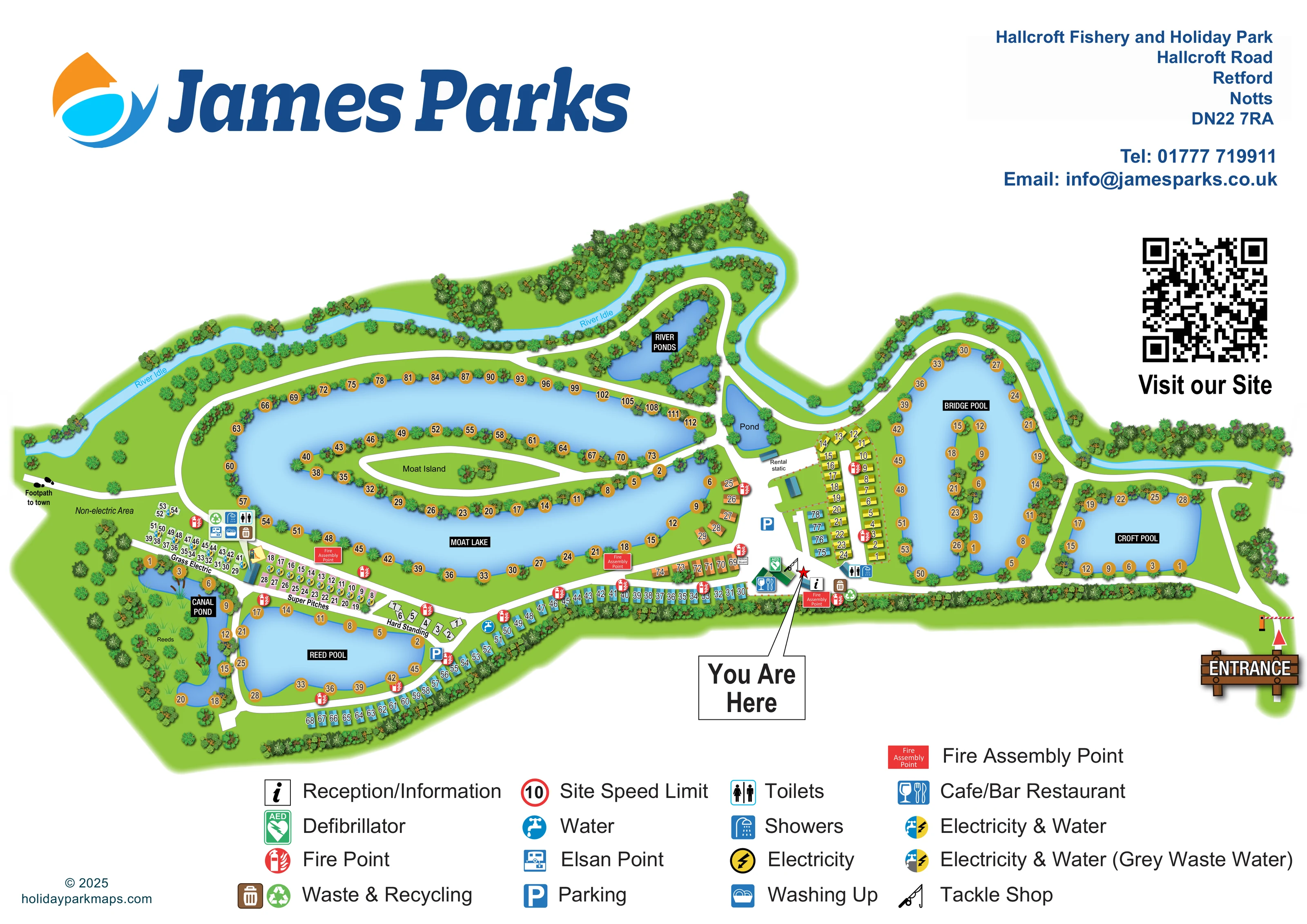
Moat Lake, Reed Pool, Canal Pond, Bridge Pool and Croft Pool are named, with ochre numbered fishing-position markers around their banks and islands.
ILLUSTRATED PARK MAP · P152
Hallcroft Fishery and Holiday Park, Hallcroft Road, Retford, Notts · United Kingdom
 Enlarge the map ↗
A SENSE OF THE PLACE
Hallcroft Fishery and Holiday Park is based at Hallcroft Fishery and Holiday Park, Hallcroft Road, Retford, Notts. The operator describes more than 60 acres of Nottinghamshire countryside. Touring caravans, motorhomes, tents and two-bedroom holiday homes with private hot tubs are offered.
On-site tackle shop, children's play area and recreational space are listed. Six fishing lakes and a stretch of the River Idle are available. Kingfisher Bar and Grill serves food and drinks and has pool and darts.
LOOK CLOSER
Moat Lake, Reed Pool, Canal Pond, Bridge Pool and Croft Pool are named, with ochre numbered fishing-position markers around their banks and islands.
The River Ponds occupy a wooded northern pocket, while a smaller waterbody labelled 'Pond' lies near the rental static.
A narrow, winding blue river follows much of the upper boundary, with its name repeated along the western stretch.
A long island within Moat Lake has a white access route and fishing positions along its banks.
Dense illustrated planting encloses the park and fringes the water. Canal Pond contains a broad green interior with reed illustrations and a 'Reeds' label.
The entrance is at the far right, marked by a striped barrier, red arrow and large timber-style sign.
White routes connect the entrance, central facilities, accommodation rows and lake circuits, including access onto the long islands.
A signed route leaves the western edge, identified by a footprint graphic and 'Footpath to town' label.
Moat Lake, Reed Pool, Canal Pond, Bridge Pool and Croft Pool are named, with ochre numbered fishing-position markers around their banks and islands.
The River Ponds occupy a wooded northern pocket, while a smaller waterbody labelled 'Pond' lies near the rental static.
A narrow, winding blue river follows much of the upper boundary, with its name repeated along the western stretch.
A long island within Moat Lake has a white access route and fishing positions along its banks.
Dense illustrated planting encloses the park and fringes the water. Canal Pond contains a broad green interior with reed illustrations and a 'Reeds' label.
The entrance is at the far right, marked by a striped barrier, red arrow and large timber-style sign.
White routes connect the entrance, central facilities, accommodation rows and lake circuits, including access onto the long islands.
A signed route leaves the western edge, identified by a footprint graphic and 'Footpath to town' label.
An information symbol marks the central arrival hub, beside the red star targeted by the large 'You Are Here' callout.
A dining symbol identifies the green-roofed building at the central facilities hub.
A fishing-rod symbol locates the tackle shop beside the central arrival and reception area.
A small illustrated slide and play surface appear beside the western service buildings, between the Grass Electric and Super Pitches sections.
Grouped toilet and shower symbols appear at the western touring facilities and near the accommodation block beside Bridge Pool.
Washing-up and Elsan symbols are grouped with the western touring service facilities.
Water points and combined electricity-and-water symbols are mapped. Super Pitches carry the combined service symbol that includes grey waste water.
Blue parking symbols identify spaces at the central hub and beside the western lakeside touring junction.
Waste and recycling symbols appear at the central facilities and western touring service area, with another waste point near the eastern accommodation block.
Red fire-point symbols are distributed through the accommodation and lakeside areas. Larger red assembly-point panels mark several locations along the main southern route.
A green AED symbol is placed at the central facilities hub.
A small notice-board label is positioned beside the southern route, immediately west of the main facilities.
The legend includes a red-ringed speed-limit symbol; a corresponding position is not clearly identifiable on the plan.
Park information names the food-and-drink venue as Kingfisher Bar and Grill and mentions pool and darts. These details are not labelled on the map.
READING THE MAP
Fishing lakes shape almost every part of this illustrated map of Hallcroft Fishery and Holiday Park in Retford, Nottinghamshire. The broad, landscape-format plan brings together lakeside accommodation, touring pitches and visitor facilities, with the River Idle winding along its upper edge. Moat Lake and its long central island form the main visual landmark, while the smaller pools give visitors recognisable destinations across the site.
The map shows a clear arrival route from the barrier entrance on the right to a central hub containing reception, a tackle shop and a café, bar and restaurant. At the western end, touring accommodation is divided into Hard Standing, Super Pitches and Grass Electric, with an open non-electric area beyond. Numbered caravan illustrations follow the southern boundary and occupy smaller groups beside the lakes.
Dense tree planting, shaded blue water and a reed-filled pond give the plan its particular character. A large facility legend and prominent 'You Are Here' marker support practical navigation without losing the fishery's distinctive waterside layout.
The plan is arranged as an elongated chain of waterbodies, routes and accommodation areas. Moat Lake occupies the centre-left, wrapping around Moat Island and its white access route. Reed Pool and Canal Pond sit below and to the west; Canal Pond is distinguished by a broad reed-filled interior. Bridge Pool, with its narrow island, and Croft Pool occupy the eastern half. The River Ponds and a smaller labelled pond add further landmarks near the upper centre, while the River Idle traces the wooded northern boundary.
Ochre circular numbers identify fishing positions along the banks and islands. Accommodation numbers use a separate treatment, appearing over coloured caravan roofs or pale touring-pitch outlines. The western touring strip is explicitly divided into Hard Standing, Super Pitches and Grass Electric. Service icons distinguish pitch connections, including the grey-waste provision indicated for Super Pitches. The adjacent non-electric area remains open rather than subdivided into numbered plots.
The entrance is emphasised with a barrier, red arrow and timber-style sign. From here, white routes lead past Croft Pool towards the central reception and information point, tackle shop, dining building, parking and defibrillator. A large 'You Are Here' box points to a red star at this hub. Toilets and showers appear at two service locations; washing-up and Elsan facilities are grouped in the western touring area, beside a small illustrated playground. Waste, recycling, water and fire symbols are distributed through the plan, with larger red panels identifying assembly points. A footpath to town leaves the western edge.
The single artwork is framed by James Parks branding, contact details, a website QR code and a multi-column legend beneath the illustrated site.
KEEP EXPLORING
Chosen for shared landscapes, accommodation or facilities.
 Explore the map ↗
United Kingdom
Woodland park map with mixed pitches, bell tents, lodges and a fishing lake.
 Explore the map ↗
United Kingdom
Illustrated caravan park plan with woodland and riverside walks, fishing pools and wildlife panels.
 Explore the map ↗
United Kingdom
A woodland estate park map combining caravan loops, touring pitches, riverside paths and Bruce’s Cave landmarks.
Features may come from the sample artwork, its key or published park information. Approximate numbers describe the drawing and may cover only part of a park. They are intended to help you compare map examples. Current facilities and booking information should be checked with the park.
LET’S MAP YOUR PARK
For a map quotation, find your park and draw a rough boundary around it. The area you select helps us work out the design time and price.
Draw your park for a quote ↗Or talk to our map designers
01751 473136