
Fishing lake
Tree-fringed blue lake at the upper end of the plan. The illustrated version adds a small waterside platform.
ILLUSTRATED PARK MAP · P029
Forewood Lane, Crowhurst, near Battle, East Sussex · United Kingdom
 Enlarge the map ↗
A SENSE OF THE PLACE
Bluebell Coppice Park is based at Forewood Lane, Crowhurst, near Battle, East Sussex. The site includes ten acres of ancient woodland and a small catch-and-release fishing lake. Bell tents and woodland lodges are also offered. Touring options include grass and hardstanding pitches for tents, caravans, motorhomes and campervans, with electric and non-electric choices.
An honesty shop, laundry and shared freezer and microwave are provided. Shower facilities include a wheelchair-accessible family wet room.
LOOK CLOSER
Tree-fringed blue lake at the upper end of the plan. The illustrated version adds a small waterside platform.
A narrow blue watercourse runs from the lake through the lodge area towards the arrival buildings. Timber-style crossings are especially clear in the illustrated version.
A substantial wooded belt occupies the left side and encloses much of the accommodation and approach.
A broad green field with sheep illustrations separates the entrance road from the main accommodation. It is not labelled as camping provision.
Information symbol beside Bluebell Barn on the arrival road, below the main accommodation area.
Shop symbols appear near reception and in the eastern facilities callout; coffee is marked at the eastern service building. The companion page identifies an honesty/coffee shop.
A grouped callout on the eastern edge of the pitches locates these shared facilities without crowding the building illustration.
Repeated blue tap symbols distributed through the accommodation area.
Information symbol beside Bluebell Barn on the arrival road, below the main accommodation area.
Shop symbols appear near reception and in the eastern facilities callout; coffee is marked at the eastern service building. The companion page identifies an honesty/coffee shop.
A grouped callout on the eastern edge of the pitches locates these shared facilities without crowding the building illustration.
Repeated blue tap symbols distributed through the accommodation area.
Grey-water symbols appear beside staff positions; a toilet-waste symbol is placed near the upper hardstanding row. The companion page also describes motorhome grey-water disposal near reception.
General waste is marked near reception, with dog-waste symbols at several points along the accommodation and arrival routes.
Red fire-point symbols are distributed near reception, the eastern facilities and the lake approach.
Blue parking symbol beside the reception and Bluebell Barn cluster.
Labelled within the central accommodation area on the flat plan, alongside the bell-tent positions and hardstanding pitches.
Bright yellow pitch rectangles identify this distinctive pitch category in two central groups.
A gazebo is shown near Pine and the wedding barn; the richly illustrated version also depicts one beside the lake approach.
Named building landmarks distinguish the arrival cluster, the western woodland edge and the eastern facilities area. Their labels do not establish particular bookable services.
A house is labelled below reception, with Warden and Night Warden positions within the accommodation layout.
Tree-fringed blue lake at the upper end of the plan. The illustrated version adds a small waterside platform.
A narrow blue watercourse runs from the lake through the lodge area towards the arrival buildings. Timber-style crossings are especially clear in the illustrated version.
A substantial wooded belt occupies the left side and encloses much of the accommodation and approach.
Paired footprint marks trace an elongated woodland route, with several labelled entry points connecting it to the lodge and reception areas.
A broad green field with sheep illustrations separates the entrance road from the main accommodation. It is not labelled as camping provision.
A red Entrance & Exit marker links Forewood Lane to a long curving approach. External arrows indicate Crowhurst and Battle, while a lower branch points towards a farm.
Repeated red-ringed speed symbols mark the arrival and accommodation roads.
The companion guest-information page describes a freezer, microwave and books, games and DVDs associated with the coffee/honesty shop.
Operator information identifies a family wet room within the shower facilities; the map does not separately locate or symbolise it.
READING THE MAP
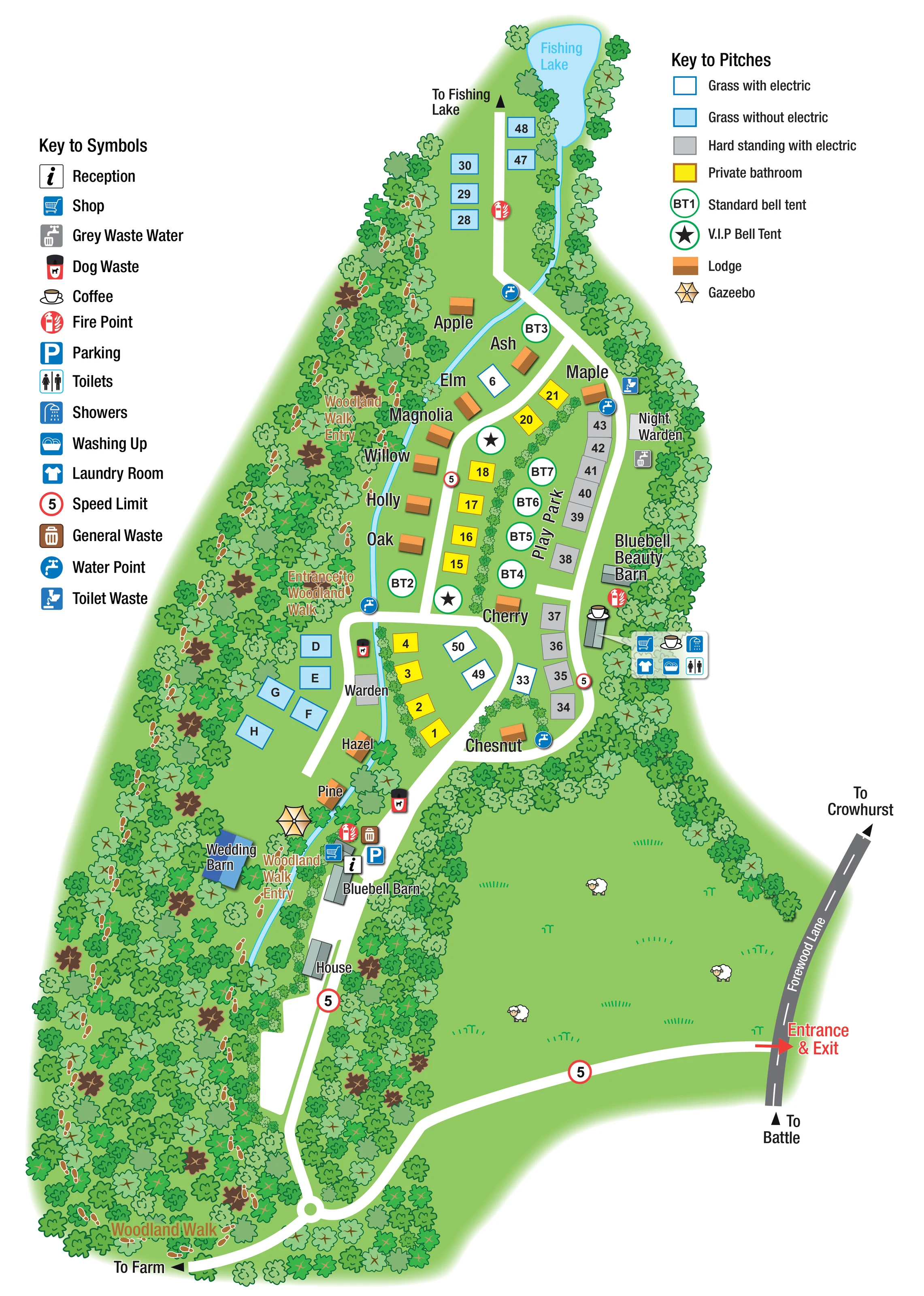
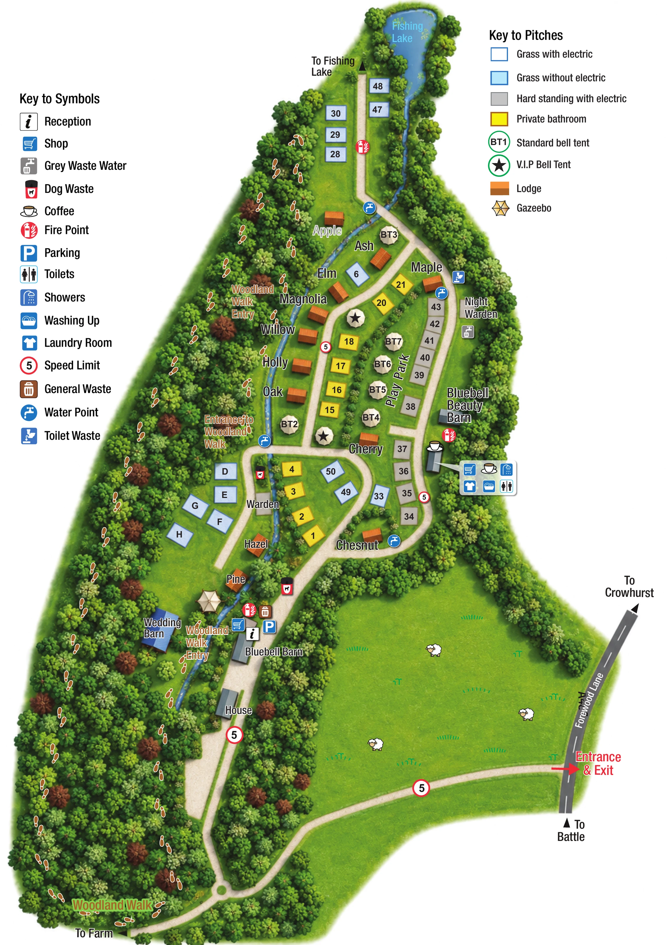
Bluebell Coppice Park’s map brings together a woodland campsite, tree-named lodges and bell-tent accommodation in one elongated portrait plan. Set at Crowhurst, near Battle in East Sussex, the park is approached from Forewood Lane across the edge of a green pasture. The map follows that arrival route past the house and reception before opening into a compact network of pitches, lodges and shared facilities, with a fishing lake at the far end.
The woodland is central to the composition rather than simply a decorative border. A footprint-marked walk runs through the broad wooded strip on the left, with several entry points connecting it to the accommodation. A blue watercourse threads between the lodges and is crossed by small bridges in the pictorial treatment.
This sample includes both a crisp, flat-colour plan and a more richly shaded illustrated version, together with a companion guest-information page. Separate facility and pitch keys explain the mix of electric and non-electric grass, hardstanding, private-bathroom pitches and bell tents. It is a useful example of mapping a small mixed park where landscape, accommodation choice and everyday navigation all need clear treatment.
The main plan is organised around a long approach from the lower-right Forewood Lane entrance. Direction arrows identify Crowhurst and Battle, while the internal road curves around the pasture and a small circular junction before passing the house and Bluebell Barn reception cluster. A separate branch points towards the farm. Above reception, the roads divide into an irregular loop and connecting spurs serving the accommodation, with a narrow extension towards the fishing lake.
Accommodation is shown through a deliberately simple visual system. Grey hardstanding pitches follow the eastern lane, yellow private-bathroom pitches occupy central rows, and white or pale-blue blocks distinguish electric and non-electric grass. Green-ringed circles identify standard bell tents, with black stars marking the V.I.P. category. Orange-roofed lodges carry tree names and largely follow the watercourse along the western side. The flat plan also labels a play park in the central area.
Facilities are located with familiar icons. Reception, parking, shop, waste and fire-point symbols gather near Bluebell Barn. An eastern building callout groups coffee, shop, toilets, showers, washing up and laundry, while water taps and disposal points are distributed through the pitch area. Wedding Barn and Bluebell Beauty Barn provide additional named landmarks.
The first map uses outlined trees, white roads and flat colours. The third artboard presents the same layout with shaded foliage, textured grass, dimensional buildings, small bridges and a waterside platform. Cream legend panels with green headings frame this pictorial version. Both treatments retain the footprint-marked woodland walk and its entry labels. The accompanying information page uses a monochrome park heading and camping-themed line drawings above writable boxes and practical guest information, with a QR code and social links at the foot.
 Enlarge this map ↗
KEEP EXPLORING
Chosen for shared landscapes, accommodation or facilities.
 Explore the map ↗
United Kingdom
Illustrated caravan park plan with woodland and riverside walks, fishing pools and wildlife panels.
 Explore the map ↗
United Kingdom
Illustrated farm campsite map with touring pitches, pods, camping fields and a riverside dog-walk route.
 Explore the map ↗
United Kingdom
A woodland estate park map combining caravan loops, touring pitches, riverside paths and Bruce’s Cave landmarks.
Features may come from the sample artwork, its key or published park information. Approximate numbers describe the drawing and may cover only part of a park. They are intended to help you compare map examples. Current facilities and booking information should be checked with the park.
LET’S MAP YOUR PARK
For a map quotation, find your park and draw a rough boundary around it. The area you select helps us work out the design time and price.
Draw your park for a quote ↗Or talk to our map designers
01751 473136