
Dog-walk area
A labelled grass area with a dog silhouette and branching white paths occupies the far upper-right corner beside a bend in the watercourse.
ILLUSTRATED PARK MAP · P133
Gill Head Farm, Troutbeck, Penrith, Cumbria · United Kingdom
 Enlarge the map ↗
A SENSE OF THE PLACE
Gill Head Farm offers caravan and camping stays at Troutbeck near Penrith, with a Lake District backdrop. The grounds provide sheltered, level spaces for touring and camping.
Timber camping pods offer an alternative to pitching a tent while retaining a camping-style stay. The map helps visitors understand the accommodation layout and shared spaces before exploring the surrounding Lakes area.
LOOK CLOSER
A labelled grass area with a dog silhouette and branching white paths occupies the far upper-right corner beside a bend in the watercourse.
A bright blue winding watercourse crosses the upper part of the site and wraps around the riverside camping area. A waterfall is labelled near the upper-right bend.
Dense illustrated trees and shrubs divide accommodation groups, border the watercourse and frame the lower camping field.
A communal area is labelled beside the central touring loop and illustrated play space.
A swing-style play illustration marks the shared space at the lower side of the touring loop.
Toilet and shower symbols mark facilities around the central accommodation area and beside the lower camping field; a further toilet symbol appears beside the upper dog-walk route.
Green recycling symbols recur beside accommodation routes, the working farm buildings and the lower field.
Blue tap symbols identify water points in the lower camping area; water provision is also included in the keys.
A communal area is labelled beside the central touring loop and illustrated play space.
A swing-style play illustration marks the shared space at the lower side of the touring loop.
Toilet and shower symbols mark facilities around the central accommodation area and beside the lower camping field; a further toilet symbol appears beside the upper dog-walk route.
Washing up appears in the general symbol key, and a wash-up area is listed in the communal-area panel. A separate washing-up position is not clearly marked on the plan.
Green recycling symbols recur beside accommodation routes, the working farm buildings and the lower field.
Blue tap symbols identify water points in the lower camping area; water provision is also included in the keys.
Red fire-point symbols are distributed through the touring, camping and lodge/caravan areas.
Yellow lightning symbols accompany orange tent illustrations in several camping areas.
Blue parking signs identify several parking locations beside shared facilities, the lower camping field and the upper walking route.
A prominent timber-style entrance sign marks arrival beside the working farm buildings.
Circular signs displaying 10 recur on the internal routes. The artwork does not state the unit.
A pink dotted route runs from the central arrival area northwards, crosses the watercourse and continues along the upper edge towards the dog-walk area.
A labelled grass area with a dog silhouette and branching white paths occupies the far upper-right corner beside a bend in the watercourse.
A bright blue winding watercourse crosses the upper part of the site and wraps around the riverside camping area. A waterfall is labelled near the upper-right bend.
Dense illustrated trees and shrubs divide accommodation groups, border the watercourse and frame the lower camping field.
Large working farm buildings anchor the entrance area, while a separately labelled private house stands beside the central touring loop.
A small grey-roofed building near the watercourse is labelled Kipper Cabin; its precise visitor use is not specified.
Reception is included in the symbol key, without a clearly identifiable corresponding marker on the main plan.
General waste appears in both facility panels, and chemical waste is listed in the communal-area panel. These entries do not establish separate disposal locations.
A motorhome service area is listed in the communal-area panel, but a distinct position is not clearly plotted.
The communal-area panel lists food preparation, WiFi, TV, a toaster, kettles and a kit drying area. These are panel entries rather than individually placed map symbols.
A laundry room is included in the general symbol key, without a clearly plotted location.
READING THE MAP
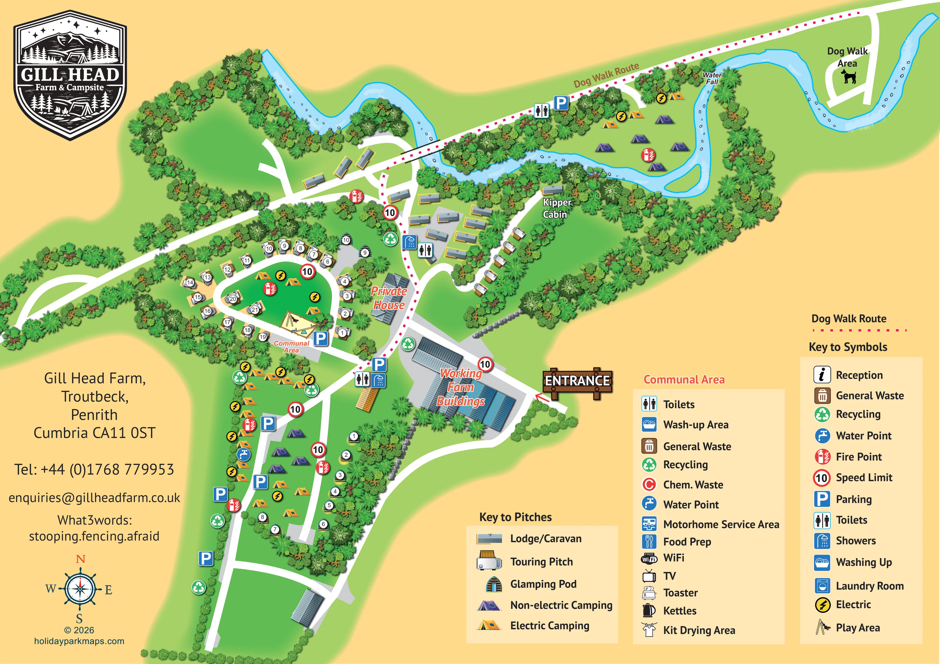
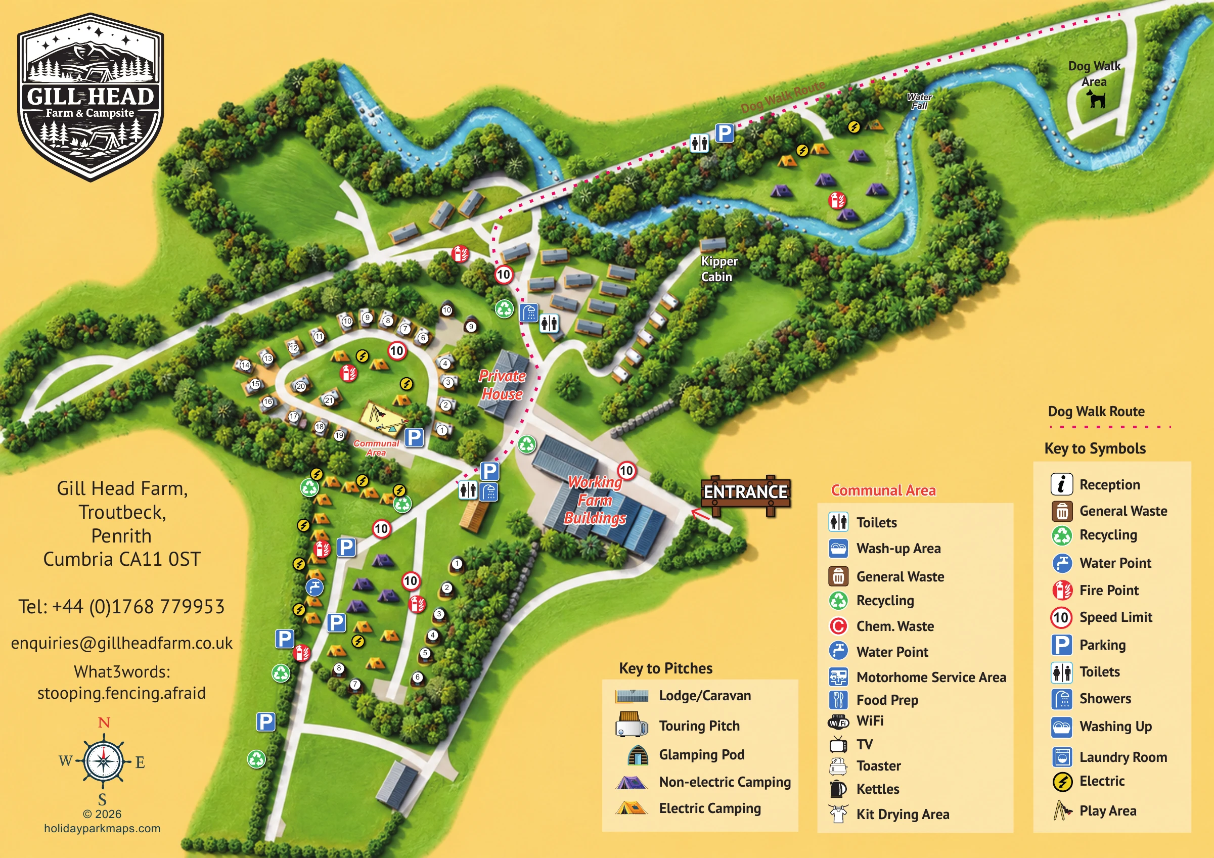
This illustrated map of Gill Head Farm at Troutbeck, near Penrith in Cumbria, brings a working farm campsite into a single, recognisable visitor plan. Touring pitches, glamping pods, lodge/caravan accommodation and electric and non-electric camping are shown among green fields and dense planted boundaries, with a winding watercourse shaping the upper part of the site.
The map gives particular attention to the relationship between arrival, accommodation and shared spaces. A timber-style entrance sign sits beside the working farm buildings, while the central touring loop, communal area and southern camping field are easy to distinguish. Further north, a riverside camping pocket and a dotted dog-walk route extend the plan beyond the main accommodation hub towards a labelled waterfall and dog-walk area.
A large Gill Head Farm & Campsite shield establishes the identity of the page. Colour-coded facility symbols, numbered accommodation markers and separate accommodation and service keys support the more pictorial elements. The result is a sample suited to rural campsites where visitors need to understand several accommodation types, branching routes and landscape features together.
The plan is organised around an entrance beside a cluster of working farm buildings. White internal routes branch from this arrival area towards a central touring loop, a long southern camping field and smaller accommodation groups to the north and east. A private house is clearly labelled beside the loop, keeping it visually distinct from visitor accommodation.
Touring-caravan illustrations follow the loop and a short eastern row. Arched timber pod symbols sit among these groups and around the lower field, while elongated grey-roofed units correspond to the combined Lodge/Caravan category in the pitch key. Orange tents represent electric camping and purple tents represent non-electric camping. Their placement communicates the character and distribution of the camping areas rather than a precise pitch capacity.
The central communal area includes an illustrated play space. Parking, toilets, showers, water, recycling and fire-point symbols appear around the site, with yellow lightning symbols distinguishing electric camping provision. A separate communal-area panel lists further provisions, including washing up, food preparation, WiFi, TV and kit drying. The main key also explains entries such as reception and laundry, although not every keyed item has a clearly plotted location.
Across the upper plan, a blue watercourse winds through thick tree planting and encloses a quieter camping pocket. The pink dotted dog-walk route crosses the watercourse and follows the upper boundary towards a labelled waterfall and dog-walk area. Kipper Cabin is named close to the water.
The single landscape-format artboard balances its irregular site outline with a large upper-left logo, lower-left contact block and compass, and three lower-right keys. The accompanying detail images enlarge the legends from this same composition.
 Enlarge this map ↗
KEEP EXPLORING
Chosen for shared landscapes, accommodation or facilities.
 Explore the map ↗
United Kingdom
Woodland park map with mixed pitches, bell tents, lodges and a fishing lake.
 Explore the map ↗
United Kingdom
A woodland estate park map combining caravan loops, touring pitches, riverside paths and Bruce’s Cave landmarks.
 Explore the map ↗
United Kingdom
Woodland holiday homes, named camping fields and farm buildings on a colour-coded Nether Wasdale park map.
Features may come from the sample artwork, its key or published park information. Approximate numbers describe the drawing and may cover only part of a park. They are intended to help you compare map examples. Current facilities and booking information should be checked with the park.
TAKE A CLOSER LOOK
View the illustrated map in detail or choose a file to download. These are sample maps; contact the park for current visitor information.

LET’S MAP YOUR PARK
For a map quotation, find your park and draw a rough boundary around it. The area you select helps us work out the design time and price.
Draw your park for a quote ↗Or talk to our map designers
01751 473136