
Tree-lined boundaries and internal hedges
Repeated rounded trees enclose most of the park. Smaller tree and shrub chains divide touring rows, holiday-home plots and entrance-side groups.
ILLUSTRATED PARK MAP · P409
Bilton Park Village Farm, Bilton Ln, Harrogate, North Yorkshire · United Kingdom
 Enlarge the map ↗
A SENSE OF THE PLACE
Bilton Park Village Farm provides touring pitches at Bilton on the edge of Harrogate. Its hardstanding spaces have electric connections, with water and grey-water services available on many pitches.
A small shop supplies essentials and camping gas. The park's approach centres on a quieter touring stay, with Harrogate and the surrounding North Yorkshire area available to explore from this village location.
LOOK CLOSER
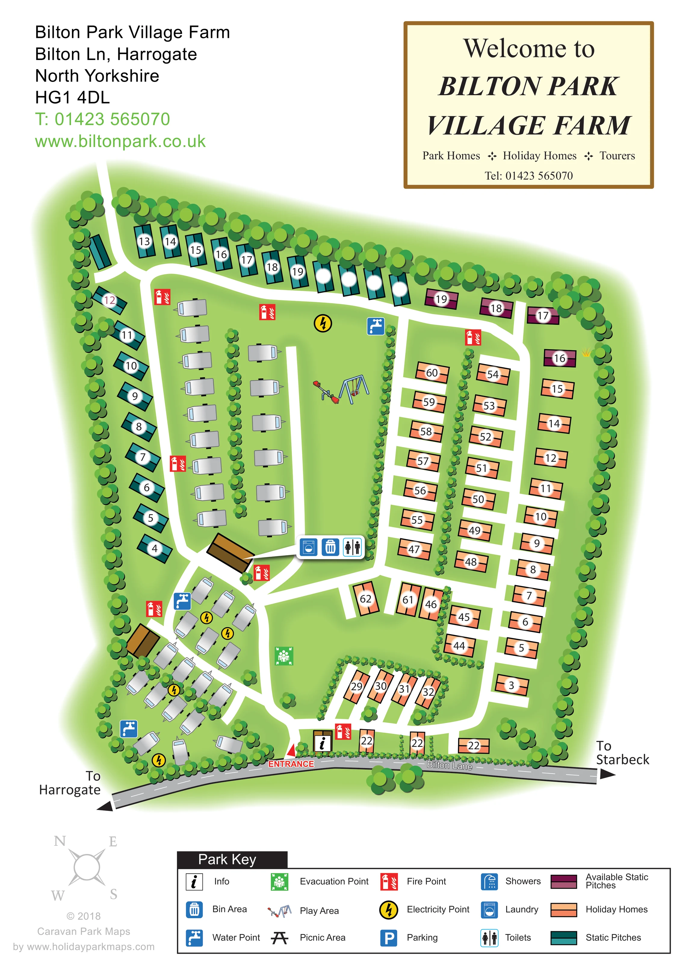
Repeated rounded trees enclose most of the park. Smaller tree and shrub chains divide touring rows, holiday-home plots and entrance-side groups.
A long grass-coloured space separates the main touring rows from the right-hand holiday-home section and contains the illustrated playground.
An information symbol marks a small brown-roofed building immediately inside the Bilton Lane entrance.
A combined callout for toilets, laundry and bins points towards the brown-roofed service building at the lower end of the main touring rows.
Blue tap symbols appear beside the upper central green and within the lower-left touring area.
Yellow lightning symbols identify electricity points in the central area and among the touring caravans near the entrance.
Red fire-point symbols are distributed around the touring rows, holiday-home section, service buildings and entrance.
A green assembly symbol marks an open area just above the entrance-side road junction.
An information symbol marks a small brown-roofed building immediately inside the Bilton Lane entrance.
A combined callout for toilets, laundry and bins points towards the brown-roofed service building at the lower end of the main touring rows.
Blue tap symbols appear beside the upper central green and within the lower-left touring area.
Yellow lightning symbols identify electricity points in the central area and among the touring caravans near the entrance.
Red fire-point symbols are distributed around the touring rows, holiday-home section, service buildings and entrance.
A green assembly symbol marks an open area just above the entrance-side road junction.
A seesaw and swing set illustrate the play area on the long central green, between touring accommodation and the holiday-home rows.
A shower symbol is included in the Park Key, but its position is not clearly marked on the main plan.
A picnic-table symbol is explained in the key; no clear matching location is visible in the main plan.
The key includes a blue parking symbol, without a clearly identifiable placement on the plan.
Repeated rounded trees enclose most of the park. Smaller tree and shrub chains divide touring rows, holiday-home plots and entrance-side groups.
A long grass-coloured space separates the main touring rows from the right-hand holiday-home section and contains the illustrated playground.
The entrance is labelled in red along the lower edge, where the internal drive meets Bilton Lane beside the information point.
Arrowheads at the ends of the depicted Bilton Lane indicate Harrogate to the left and Starbeck to the right.
White routes connect the entrance, lower touring clusters and upper perimeter, with short branches serving the holiday-home rows.
Park information describes a small shop supplying essentials and camping gas; the artwork does not identify a shop location.
READING THE MAP
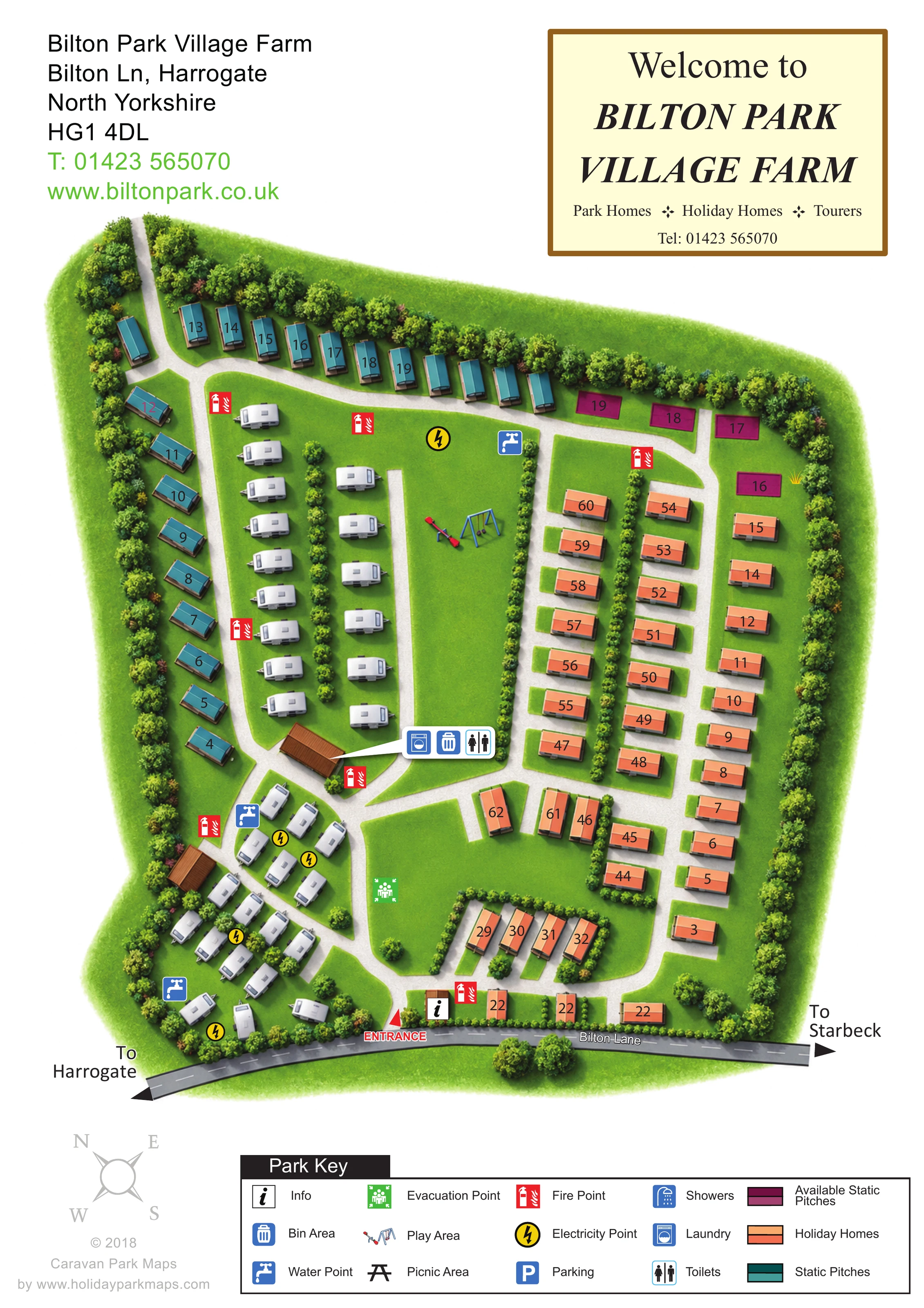
This illustrated map of Bilton Park Village Farm presents a tree-lined caravan park on Bilton Lane, at the edge of Harrogate in North Yorkshire. Its portrait layout brings together touring accommodation, holiday homes and static pitches, using distinct colours and caravan drawings to make the different areas easy to recognise. A grey roadside strip anchors the plan, with arrows towards Harrogate and Starbeck and a clearly marked entrance beside the information point.
Inside the park, white roads connect the accommodation groups around a central green. The map shows a playground, a service-building callout for toilets, laundry and bins, and distributed water, electricity and fire points. Rounded trees and small hedged divisions give the plan a softer character without obscuring its practical structure.
The large welcome panel, contact block and footer key make this a self-contained visitor sheet rather than an isolated site diagram. As a design sample, it is particularly relevant to parks that need to explain several accommodation types within one compact layout while retaining a friendly, landscaped appearance.
The plan is organised around a labelled entrance from Bilton Lane along the bottom edge. An information symbol sits immediately inside the entrance, while the roadside arrows place Harrogate to the left and Starbeck to the right. From this arrival point, white internal roads branch into the lower touring area and connect with the longer routes serving the main accommodation sections.
Teal static pitches trace the left and upper boundaries beneath a continuous belt of rounded trees. Grey touring caravans occupy two central-left rows and several smaller entrance-side clusters. Peach holiday homes dominate the right-hand side, arranged along short road spurs with planted dividers. A small purple group at the upper right is identified in the key as available static pitches. Numbered white circles provide individual plot references without requiring separate labels beside every unit.
A long central green separates the main touring rows from the holiday-home section. Swings and a seesaw mark its play area. Near the lower end of the touring rows, a white callout links laundry, bin and toilet symbols to a brown-roofed service building. Blue water points, yellow electricity symbols and red fire points are distributed through the plan, with a green evacuation-point marker closer to the entrance. Showers, parking and a picnic area are also explained in the key, although their locations are not clearly marked in the main illustration.
The single portrait artwork is completed by a traditional welcome panel, address block, compass and broad footer legend. The enlarged legend views show portions of this same sheet, not additional park sections. Soft green shading, repeated tree canopies and simple roof illustrations balance landscape character with the practical road and plot information.
 Enlarge this map ↗
KEEP EXPLORING
Chosen for shared landscapes, accommodation or facilities.
 Explore the map ↗
United Kingdom
Coastal park map with static-caravan rows, touring pitches, a camping field and two leisure clusters.
 Explore the map ↗
United Kingdom
A wooded Allerton park plan with colour-coded neighbourhoods, touring pitches and a central facilities hub.
 Explore the map ↗
United Kingdom
A wooded, mixed-accommodation park plan with winding lanes, a pool, camping areas and a clear facility key.
Features may come from the sample artwork, its key or published park information. Approximate numbers describe the drawing and may cover only part of a park. They are intended to help you compare map examples. Current facilities and booking information should be checked with the park.
TAKE A CLOSER LOOK
View the illustrated map in detail or choose a file to download. These are sample maps; contact the park for current visitor information.


LET’S MAP YOUR PARK
For a map quotation, find your park and draw a rough boundary around it. The area you select helps us work out the design time and price.
Draw your park for a quote ↗Or talk to our map designers
01751 473136