
Boundary planting and pitch dividers
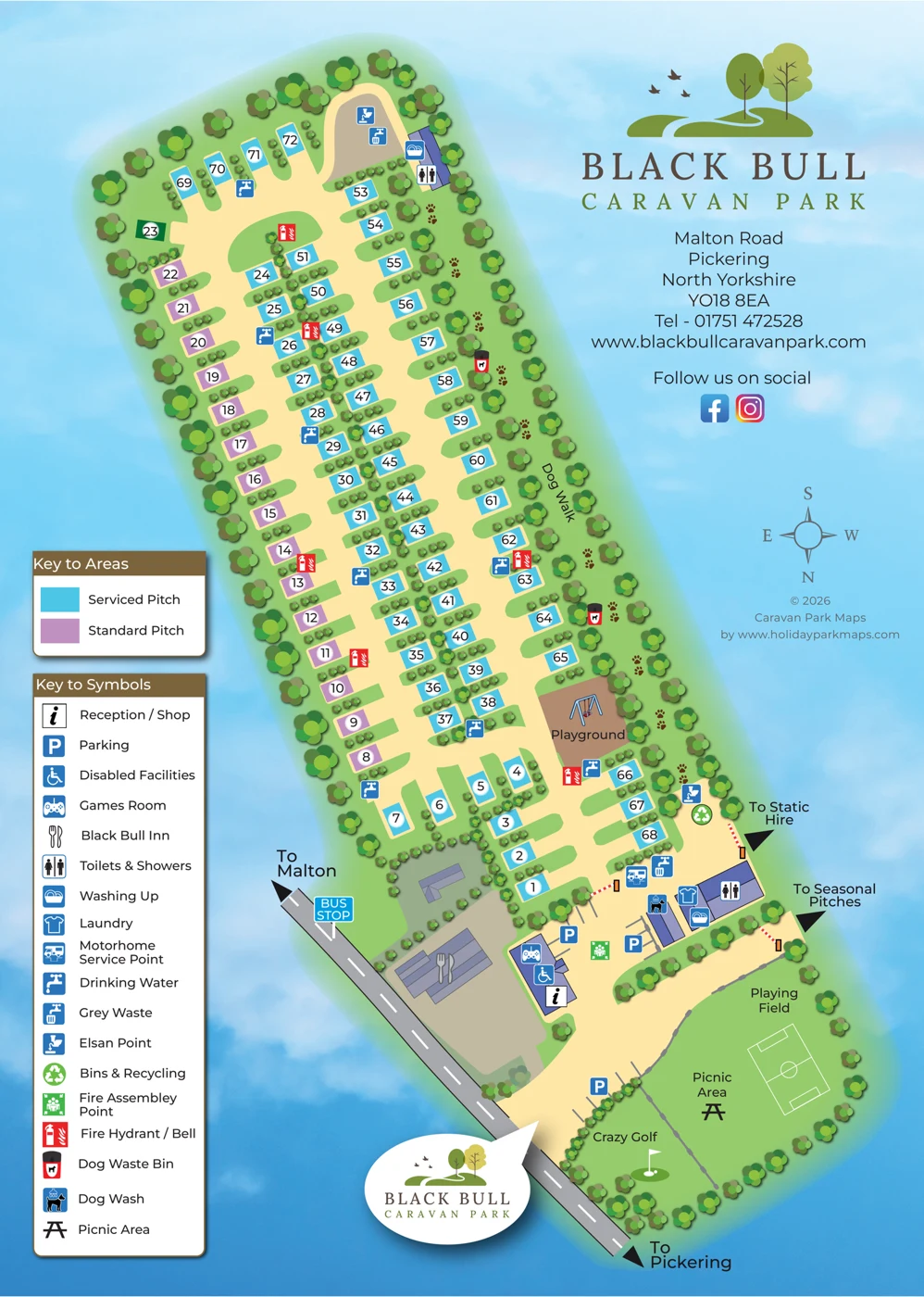
Repeated rounded tree crowns and small shrub clusters define the site edge, separate pitches and soften the entrance facilities. These are stylised landscape symbols rather than a vegetation survey.
ILLUSTRATED PARK MAP · P025
Malton Road, Pickering, North Yorkshire · United Kingdom
 Enlarge the map ↗
A SENSE OF THE PLACE
Black Bull Caravan Park is based at Malton Road, Pickering, North Yorkshire. All-weather touring pitches accommodate caravans, motorhomes and campervans; six-berth static caravans are offered for hire.
Heated washrooms, an accessible family shower/toilet, laundry, games room, play area and nine-hole crazy golf are listed. The pub at the park entrance is separately owned; the park also provides a motorhome service point and basic Wi-Fi.
LOOK CLOSER
Repeated rounded tree crowns and small shrub clusters define the site edge, separate pitches and soften the entrance facilities. These are stylised landscape symbols rather than a vegetation survey.
Broad green recreational space contains the playing field, picnic area and crazy golf. No area or sports-field dimensions are supplied.
A planted green strip outside the pitch row forms the illustrated setting for the dog walk. Its width, surface and degree of enclosure cannot be measured from the artwork.
Combined reception and shop, represented by an information symbol on the entrance-side building.
Parking is marked beside the reception and main washrooms, with further bays along the entrance approach. The reverse discusses use of the car park for additional vehicles.
Accessible facilities are marked at reception. The reverse locates them in the reception lobby; supplied research describes an accessible family shower/toilet. No accessibility certification is established.
Games room marked in the reception building. Opening hours printed on the reverse are not treated as current information.
Pub represented by a cutlery symbol on the building beside the external road. Separate ownership is supported by the supplied catalogue research, not stated on the map.
Combined reception and shop, represented by an information symbol on the entrance-side building.
Parking is marked beside the reception and main washrooms, with further bays along the entrance approach. The reverse discusses use of the car park for additional vehicles.
Accessible facilities are marked at reception. The reverse locates them in the reception lobby; supplied research describes an accessible family shower/toilet. No accessibility certification is established.
Games room marked in the reception building. Opening hours printed on the reverse are not treated as current information.
Pub represented by a cutlery symbol on the building beside the external road. Separate ownership is supported by the supplied catalogue research, not stated on the map.
Toilets and showers are marked at the entrance end and the far end of the touring field. Heated washrooms are a catalogue-only refinement.
Washing-up facilities accompany the washroom buildings.
Laundry is marked at the main washroom building. The reverse also mentions ironing and hair-drying facilities in the laundry area.
Motorhome servicing location marked beside the touring-field barrier and grey-waste point.
Drinking-water taps are distributed through the pitch rows and near the playground.
Grey-water disposal is distinguished from drinking water and chemical-toilet disposal.
Chemical-toilet disposal points are marked separately from grey-waste facilities.
Bins and recycling are mapped opposite the main washroom area. The reverse lists paper, plastic, cardboard, glass and cans as recycling streams in the leaflet.
Assembly point marked in the entrance forecourt. This records the artwork location rather than providing current emergency instructions.
Red fire-point symbols are distributed among the pitches and beside the playground. The legend calls these Fire Hydrant / Bell, although the pictogram resembles an extinguisher and flame.
Dog-waste bins are placed along the illustrated dog-walking corridor.
Dog-washing facility marked on a narrow building beside the main washroom block.
Designated dog-walking corridor illustrated with paw prints. Its depiction does not establish current dog-admission or lead policies.
Playground illustrated as a brown surfaced area with a swing.
Open recreation area with a schematic football-pitch marking. The illustration does not establish regulation dimensions.
Picnic area labelled within the entrance-side recreation ground.
Crazy-golf area represented by a flag and putting-green icon. The supplied catalogue describes nine holes; individual holes are not drawn.
Roadside bus stop is mapped near the inn. The reverse mentions bus information and shelters, but current services and timetables are not established.
Wi-Fi is described in a boxed panel on the reverse. Access credentials are intentionally omitted from this extraction. Coverage and performance are not mapped.
A yellow emergency telephone is described on the outside reception wall. This is a historical leaflet observation, not current emergency advice.
A vending machine and change machine are described as being inside the games room.
Reception-lobby information provision includes local information, taxi numbers and bus timetables in the leaflet.
The leaflet mentions barbecue stands obtainable from reception. Historical charges and barbecue rules are not presented as current terms.
Repeated rounded tree crowns and small shrub clusters define the site edge, separate pitches and soften the entrance facilities. These are stylised landscape symbols rather than a vegetation survey.
Broad green recreational space contains the playing field, picnic area and crazy golf. No area or sports-field dimensions are supplied.
A planted green strip outside the pitch row forms the illustrated setting for the dog walk. Its width, surface and degree of enclosure cannot be measured from the artwork.
READING THE MAP
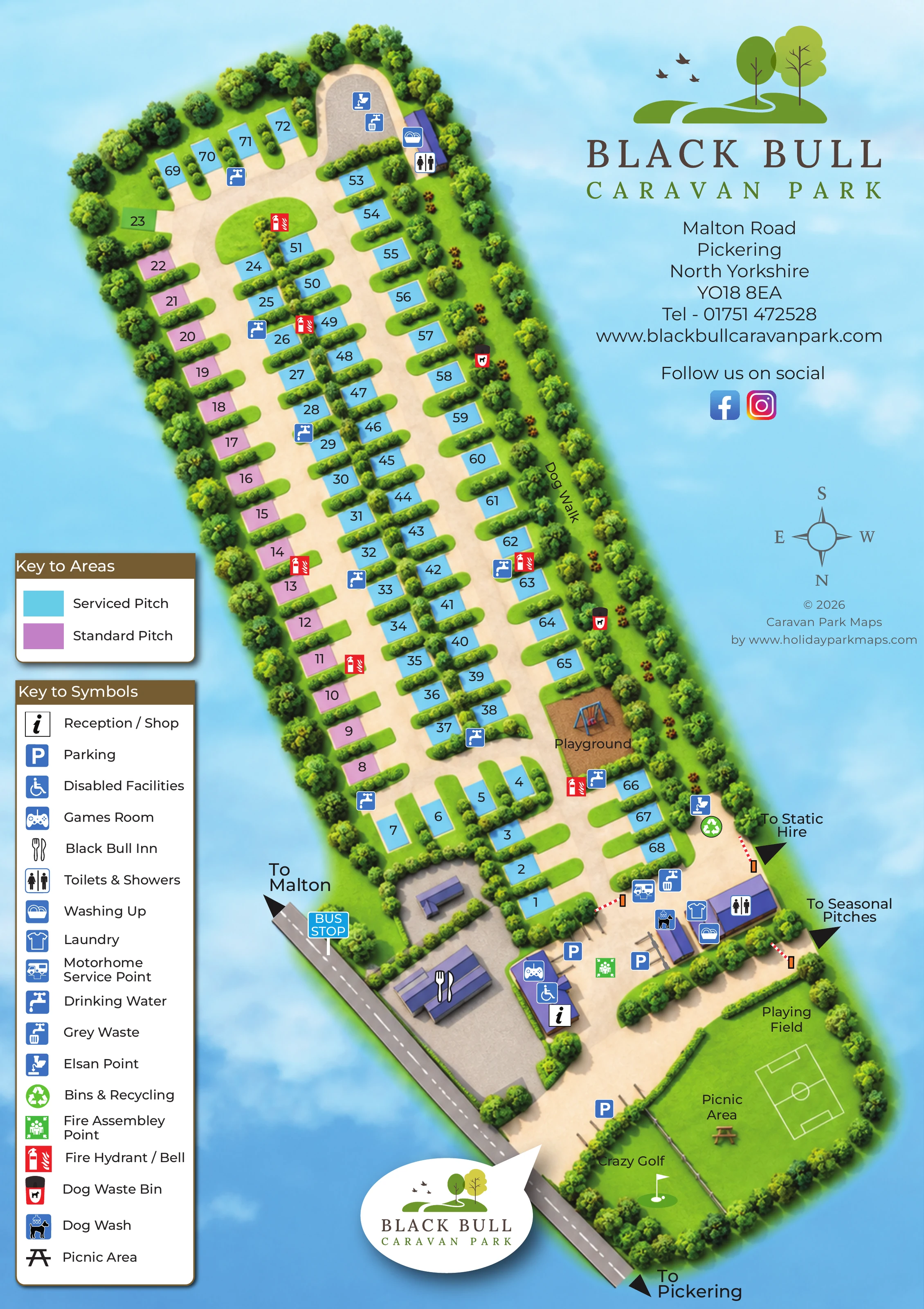
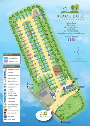
Our Black Bull Caravan Park map shows how a long touring layout can be made easy to follow with clear pitch numbers, colour-coded areas and recognisable facility symbols. The Pickering park is illustrated with a main touring field, an entrance and reception area, recreation space and a dog walk along the boundary. Directions also point towards separate static-hire and seasonal areas.
The design brings everyday visitor needs together: finding a pitch, locating the washrooms, identifying water and waste points, and reaching the play and leisure areas. A playground, playing field, picnic area and crazy golf give the sample a useful mix of practical and recreational content. The matching information reverse demonstrates how a park map can form part of a coordinated visitor leaflet.
This is a useful example for touring parks with rows of pitches, shared amenities and accommodation areas that need clear signposting. Strong numbers and restrained area colours keep the detailed plan approachable.
This two-page portrait leaflet pairs an illustrated overhead plan of Black Bull Caravan Park with a matching visitor-information reverse. The main touring field stretches diagonally from an entrance beside the roadside inn to a rounded far-end service loop. Cream-coloured drives weave between orderly pitch rows, with cyan rectangles identifying serviced pitches and mauve rectangles identifying standard pitches. Black numbers sit over soft white circular highlights. A dark-green pitch marker falls outside the categories explained in the area key.
The entrance is a strong visual anchor. Reception, the games room and accessible facilities share a building symbol, facing a cluster of washroom, laundry, washing-up and dog-wash facilities. Parking bays, an assembly point and motorhome servicing symbols occupy the surrounding forecourt. Barrier illustrations separate the main touring access from routes labelled towards static hire and seasonal pitches, neither of which is drawn individually. Further washroom and disposal facilities appear at the far end of the pitch field.
A paw-print dog walk follows the page-right boundary, passing dog-waste bins and the playground. Near the entrance, a broad green recreation area combines playing-field markings, a picnic symbol and a crazy-golf flag. Rounded tree crowns and small shrub clusters frame the site and divide pitches; they provide visual texture rather than measurable landscape information.
The design uses a cloud-textured blue backdrop, warm yellow roads, bright green ground and blue facility icons, with red reserved for fire points and dog bins. Brown-headed white panels separate the area colours from the symbol key. Large park branding and contact details occupy the upper-right space, while a branded white pointer highlights the entrance. A south-up compass is provided, but there is no scale.
The reverse continues the blue background with a pale rounded panel, bold paragraph headings, blank guest-allocation fields and a boxed Wi-Fi section. Grass silhouettes finish the lower edge. Its operational text requires review before reuse, and access credentials must be redacted for a public catalogue.
 Enlarge this map ↗
KEEP EXPLORING
Chosen for shared landscapes, accommodation or facilities.
 Explore the map ↗
United Kingdom
A wooded, streamside park map with a linked farm, café, touring and cottage area.
 Explore the map ↗
United Kingdom
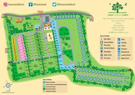
Colour-coded pitches, a leafy facilities hub and a long static-caravan wing at Haw Wood Farm, Suffolk.
 Explore the map ↗
United Kingdom
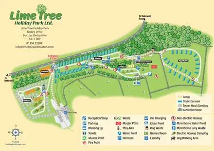
Mixed-accommodation park map with woodland, public footpaths and clearly differentiated service symbols.
Features may come from the sample artwork, its key or published park information. Approximate numbers describe the drawing and may cover only part of a park. They are intended to help you compare map examples. Current facilities and booking information should be checked with the park.
TAKE A CLOSER LOOK
View the illustrated map in detail or choose a file to download. These are sample maps; contact the park for current visitor information.


LET’S MAP YOUR PARK
For a map quotation, find your park and draw a rough boundary around it. The area you select helps us work out the design time and price.
Draw your park for a quote ↗Or talk to our map designers
01751 473136