
Tree-lined perimeter and planted divisions
Dense tree symbols frame the northern and eastern edges, with thinner boundary planting and internal groups separating accommodation.
ILLUSTRATED PARK MAP · P182
Palnackie, by Dalbeattie, Dumfries and Galloway · United Kingdom
 Enlarge the map ↗
A SENSE OF THE PLACE
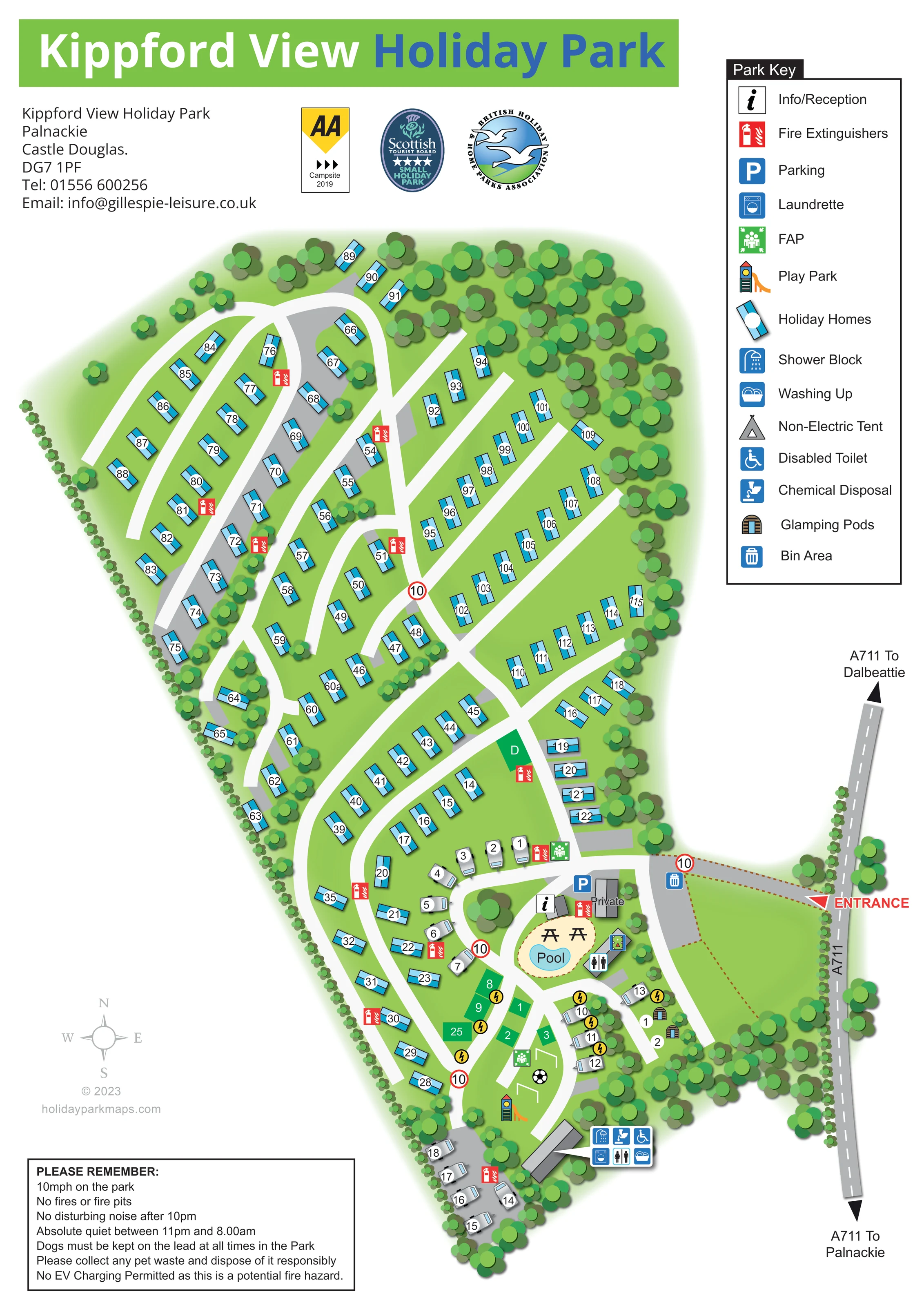
Kippford View Holiday Park is based at Palnackie, by Dalbeattie, Dumfries and Galloway. The hillside park overlooks the Urr estuary towards Palnackie. Holiday homes, glamping pods, touring and tent pitches are offered.
Park-specific facilities include a seasonal heated outdoor pool and children's play area; fishing at Big Barwhanny Loch is nearby.
LOOK CLOSER
Dense tree symbols frame the northern and eastern edges, with thinner boundary planting and internal groups separating accommodation.
An information symbol identifies a small building beside the arrival junction and pool.
A blue parking symbol marks a grey area beside reception and the building labelled Private.
A labelled blue pool sits in a cream-coloured enclosure near reception.
Two picnic-table illustrations appear within the pool enclosure.
A colourful slide-and-tower symbol marks the southern recreation area.
A football and two goal outlines identify a small recreation space beside the play equipment.
The southern amenity building carries shower, toilet and accessible-toilet symbols. A separate toilet symbol appears near the pool.
An information symbol identifies a small building beside the arrival junction and pool.
A blue parking symbol marks a grey area beside reception and the building labelled Private.
A labelled blue pool sits in a cream-coloured enclosure near reception.
Two picnic-table illustrations appear within the pool enclosure.
A colourful slide-and-tower symbol marks the southern recreation area.
A football and two goal outlines identify a small recreation space beside the play equipment.
The southern amenity building carries shower, toilet and accessible-toilet symbols. A separate toilet symbol appears near the pool.
A washing-machine symbol is grouped with the southern amenity-building facilities.
The washing-up symbol is shown at the southern amenity building.
A chemical-disposal symbol is included in the southern amenity cluster.
A blue bin symbol marks a point beside the entrance road.
Repeated red extinguisher symbols are distributed through the accommodation areas and near communal buildings.
Green gathering-point symbols, labelled FAP in the key, appear near the arrival junction and southern recreation space.
Yellow lightning-bolt circles accompany several southern touring and green pitches; these symbols are not explained in the key.
Dense tree symbols frame the northern and eastern edges, with thinner boundary planting and internal groups separating accommodation.
A red entrance label and arrow connect the park to the A711, with external directions towards Dalbeattie and Palnackie.
White roads divide into loops, curved branches and short access spurs. Red-ringed 10 markers punctuate the network.
A grey-roofed building beside reception and parking is explicitly labelled Private.
A grey tent icon appears in the key, without a clearly identifiable matching location on the plan.
READING THE MAP
This illustrated map of Kippford View Holiday Park brings a tree-lined hillside site into a clear, numbered visitor plan. Located at Palnackie in Dumfries and Galloway, the park overlooks the Urr estuary, while the artwork concentrates on the practical relationship between accommodation, arrival roads and communal facilities.
Blue holiday-home symbols dominate the broad northern half of the map, following curved roads and angled rows. Towards the narrower southern end, white touring caravans, green pitch shapes and two timber-style glamping pods introduce a different accommodation mix. Reception, parking and the outdoor pool form an easily recognised arrival hub, with play equipment, a ball-game area and an amenity building further south.
The portrait layout leaves room for a substantial facility key, contact details and visitor reminders without losing the shape of the park. Rounded trees, bright green ground and white roads make the plan approachable, while numbered units and repeated service symbols keep its main purpose practical: helping guests understand where they are staying and how the different parts of the site connect.
The map is organised around an entrance from the A711 on the right-hand side. Direction arrows identify Dalbeattie and Palnackie along the external road, while a red entrance label draws attention to the turn into the park. The access road meets a central junction beside information and reception, parking and a building marked Private. Immediately below, the labelled pool appears within a cream enclosure containing two picnic-table illustrations.
From this hub, white internal roads branch through the larger holiday-home area to the north. Cyan accommodation symbols sit in curved strips, diagonal rows and short roadside groups, each carrying a white number roundel. Grey surfaces distinguish some individual pitch areas from the surrounding green ground. Tree planting follows the boundaries and breaks up the interior, with particularly dense woodland-style illustration across the upper and right-hand edges.
The southern section combines touring caravan symbols, numbered green pitches and two brown glamping pods. Yellow lightning-bolt markers appear beside several pitches. A slide-and-tower illustration, football and goal outlines identify the recreation area. At the lower edge, a grey amenity building is accompanied by symbols for showers, toilets, an accessible toilet, laundry, washing up and chemical disposal. Extinguisher and assembly-point symbols recur elsewhere, and a bin point is marked near the entrance.
A tall key at the upper right explains the main accommodation and facility symbols. Its non-electric tent entry does not establish a specific tent location on the plan. The supplied enlargement shows this same key and adjacent holiday-home rows in greater detail; it is not a separate section map. A compass, reminder panel, tourism badges and prominent green title banner complete the portrait page.
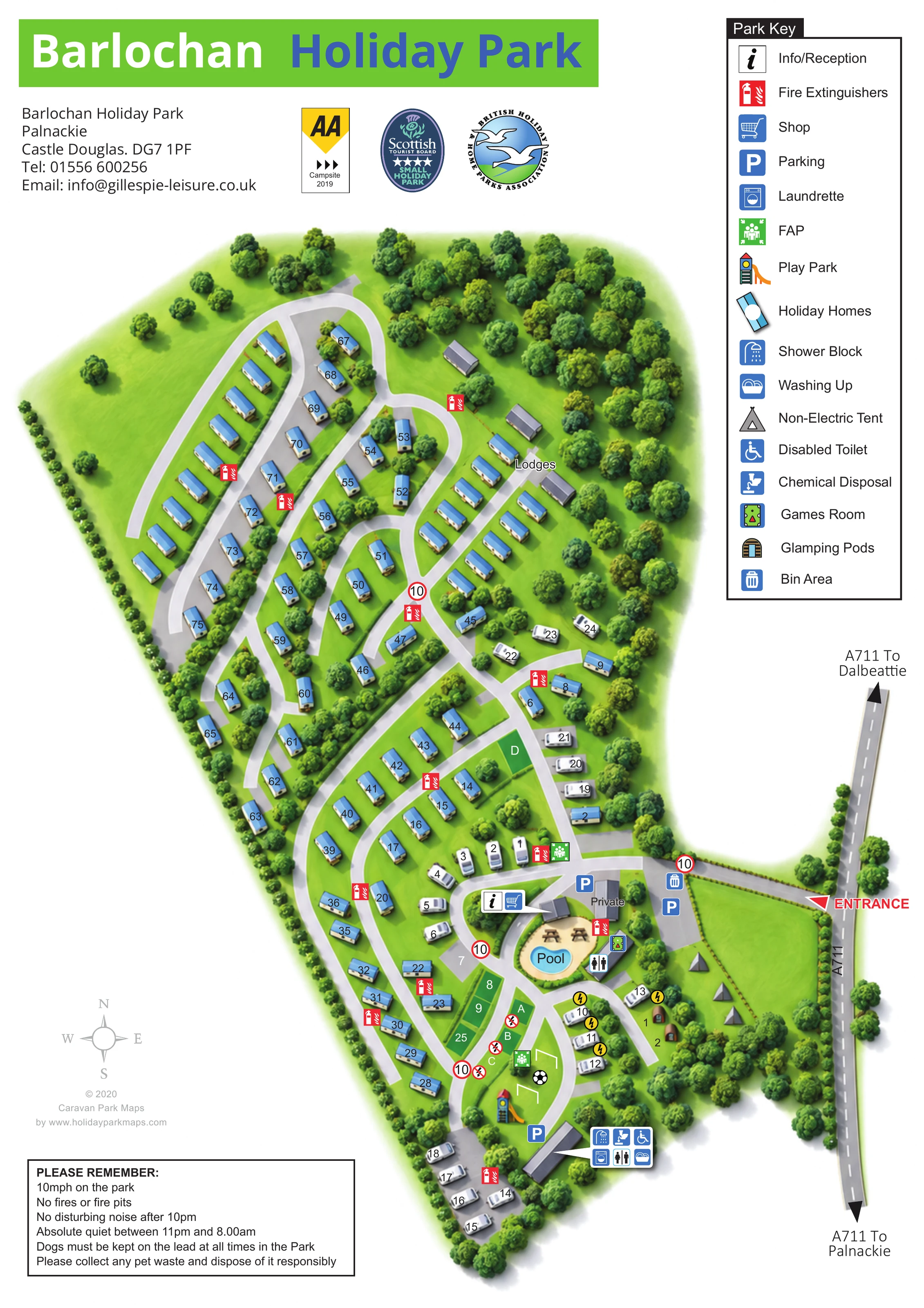
Barlochan Holiday Park is retained here as a separate historical artwork under the shared Kippford View page.
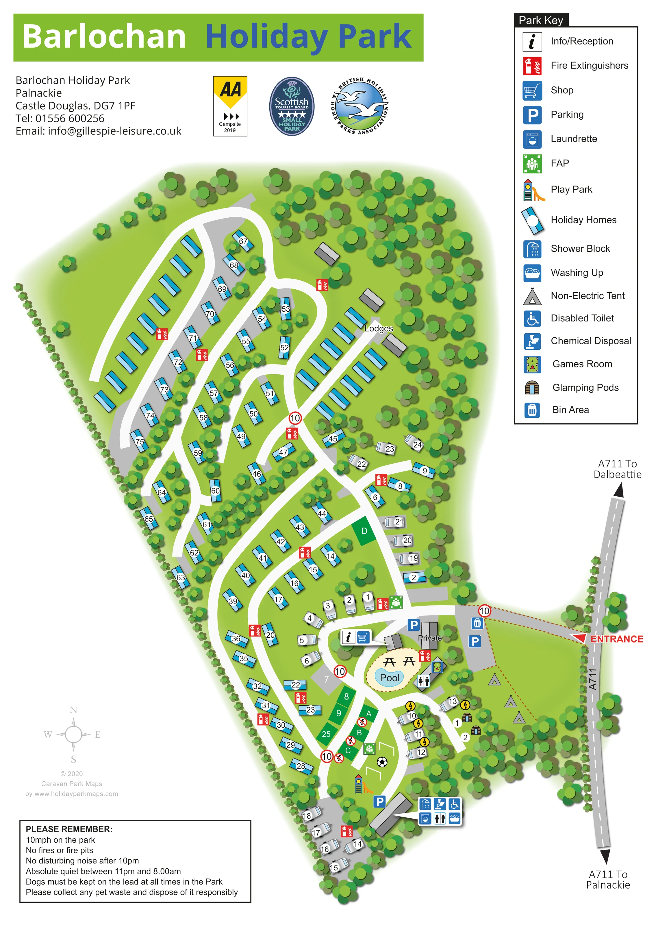
This illustrated map presents Barlochan Holiday Park, now known as Kippford View, near Palnackie in Dumfries and Galloway. Its long, wooded site is arranged around curving internal roads, with turquoise holiday homes forming the main accommodation rows and a more varied camping and touring area towards the lower end of the plan.
The entrance from the A711 is clearly separated from the accommodation lanes. Reception, the shop, parking and a labelled pool create an identifiable arrival hub, while the southern section brings together touring pitches, glamping pods, tent camping, a play park and shared amenities. A small lodge group sits against the wooded north-eastern boundary.
The artwork combines an overhead layout with pictorial trees, caravans and facility symbols. A tall key, numbered units and strong colour contrasts help visitors distinguish places to stay from the facilities they need. Retained under the park's former name, this sample illustrates an earlier layout and shows how a mixed holiday park can be presented clearly without losing the character of its planted surroundings.
 Enlarge this map ↗
KEEP EXPLORING
Chosen for shared landscapes, accommodation or facilities.
 Explore the map ↗
United Kingdom
A colour-zoned coastal park map with touring areas, woodland trails, ponds and a leisure club.
 Explore the map ↗
United Kingdom
Woodland-framed Barnsoul map with mixed accommodation, shared facilities and paw-marked walking routes.
 Explore the map ↗
United Kingdom
Colour-coded accommodation, lakeside facilities and woodland routes at Burton Constable Holiday Park & Arboretum.
Features may come from the sample artwork, its key or published park information. Approximate numbers describe the drawing and may cover only part of a park. They are intended to help you compare map examples. Current facilities and booking information should be checked with the park.
TAKE A CLOSER LOOK
View the illustrated map in detail or choose a file to download. These are sample maps; contact the park for current visitor information.


LET’S MAP YOUR PARK
For a map quotation, find your park and draw a rough boundary around it. The area you select helps us work out the design time and price.
Draw your park for a quote ↗Or talk to our map designers
01751 473136