
Tree-lined boundaries and green spaces
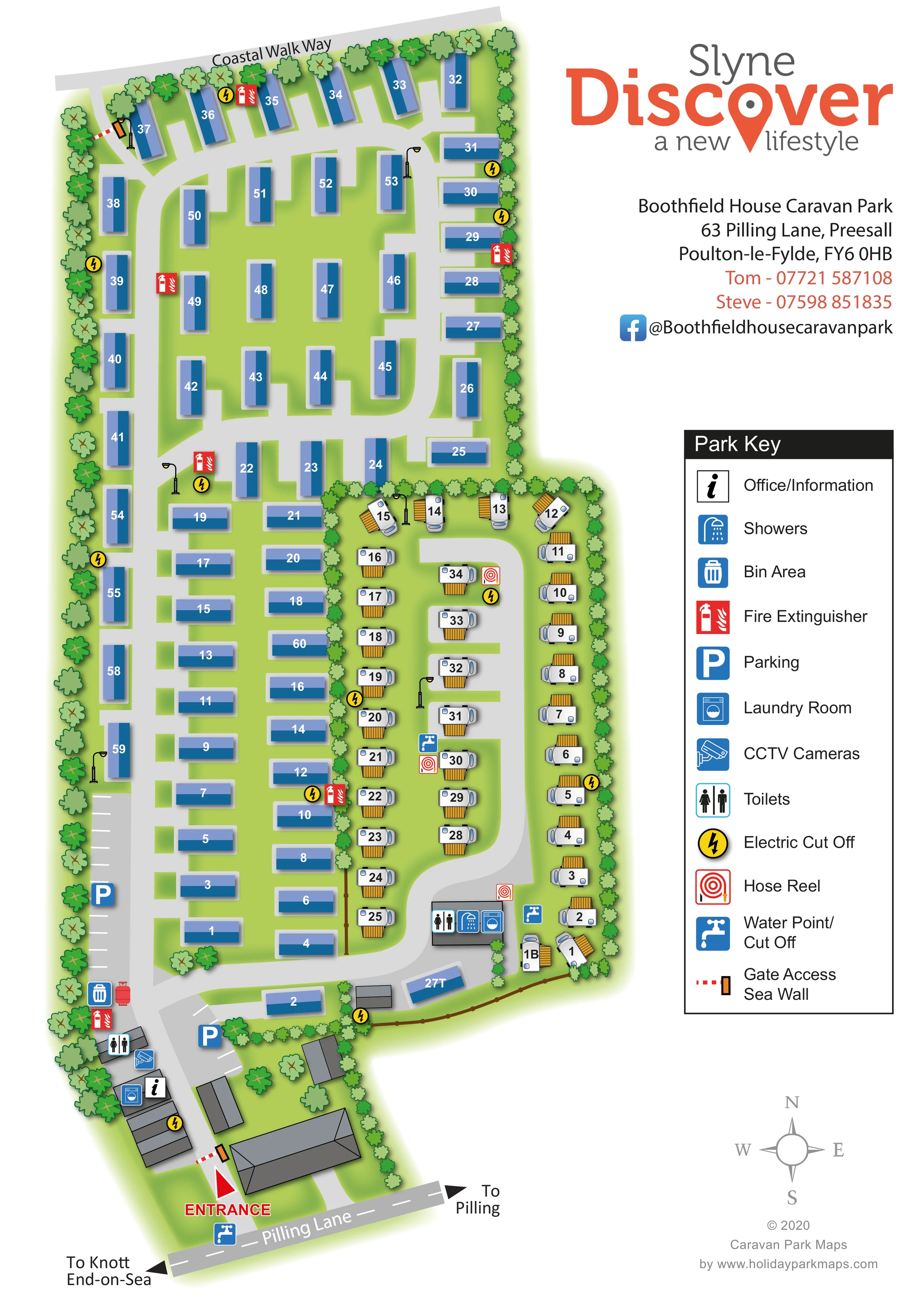
Continuous illustrated tree and shrub belts frame the park and separate the touring section from neighbouring static caravans; green ground fills the spaces between units.
ILLUSTRATED PARK MAP · P414
63 Pilling Lane, Preesall, Poulton-le-Fylde · United Kingdom
 Enlarge the map ↗
A SENSE OF THE PLACE
Boothfield House Caravan Park is located near Knott End-on-Sea in Lancashire's Over Wyre area. Its coastal setting includes direct access through park gates to footpaths overlooking Morecambe Bay.
The park welcomes families and offers seasonal touring pitches alongside its established caravan areas. Visitors can combine time by the coast with excursions to the towns and countryside around the Fylde.
LOOK CLOSER
Continuous illustrated tree and shrub belts frame the park and separate the touring section from neighbouring static caravans; green ground fills the spaces between units.
An information symbol marks a building within the entrance-side service cluster.
Toilet symbols appear at the entrance-side buildings and at the southern end of the touring area.
A shower symbol identifies the amenity building beside the touring area's southern approach.
Laundry symbols are shown at the entrance-side service buildings and the touring-area amenity block.
Blue parking symbols identify a long bay-marked strip along the western side and a smaller parking area near the entrance.
A bin-area symbol is placed beside the western parking strip near the entrance service buildings.
Blue tap symbols mark points in the touring section and beside the entrance.
An information symbol marks a building within the entrance-side service cluster.
Toilet symbols appear at the entrance-side buildings and at the southern end of the touring area.
A shower symbol identifies the amenity building beside the touring area's southern approach.
Laundry symbols are shown at the entrance-side service buildings and the touring-area amenity block.
Blue parking symbols identify a long bay-marked strip along the western side and a smaller parking area near the entrance.
A bin-area symbol is placed beside the western parking strip near the entrance service buildings.
Blue tap symbols mark points in the touring section and beside the entrance.
Red extinguisher symbols are distributed through the static caravan area and near the entrance; red hose-reel symbols occur within the touring section.
Yellow circular lightning-bolt markers identify cut-off points around both accommodation areas and near the service buildings.
A blue CCTV symbol is shown beside the entrance-side buildings.
A large red arrow and ENTRANCE label identify the southern arrival point from Pilling Lane.
A grey route labelled 'Coastal Walk Way' follows the northern edge of the park.
An orange gate with a red-and-white dashed access marker is shown at the north-west boundary beside the coastal walkway; the key describes this symbol as gate access to the sea wall.
Black arrows on Pilling Lane indicate Pilling to the right and Knott End-on-Sea to the left.
Broad pale-grey lanes connect the entrance, static caravan rows and touring enclosure, with curved junctions and turning sections.
Continuous illustrated tree and shrub belts frame the park and separate the touring section from neighbouring static caravans; green ground fills the spaces between units.
READING THE MAP
This illustrated map of Boothfield House Caravan Park brings together two distinct accommodation areas in a compact coastal site at Preesall, near Knott End-on-Sea. Blue static caravans fill the larger western and northern section, while white touring caravan symbols define a separate, tree-lined enclosure on the eastern side. The difference in drawing style makes the two areas easy to recognise before visitors read individual pitch numbers.
Arrival is anchored by a bold entrance arrow from Pilling Lane, with parking and service buildings close by. At the opposite end, the labelled Coastal Walk Way and a boundary gate connect the plan with the park's seaside setting. Toilets, showers, laundry, water points and safety equipment are identified through a substantial pictogram key.
The portrait page gives the site plan most of the left-hand space, reserving the right for branding, park details and reference information. It is a useful example of a map that needs to explain accommodation, everyday facilities and a coastal pedestrian connection without crowding the illustrated grounds.
The plan follows an elongated footprint from Pilling Lane at the bottom of the page to the Coastal Walk Way across the top. A red entrance arrow points between the southern buildings into a broad grey access lane. Nearby symbols identify office and information provision, toilets, laundry, CCTV and bins. Parking is shown both near this arrival cluster and in a long marked strip beside the western boundary.
Most static caravans appear as blue rectangular units on pale bases. Their rows change orientation to accommodate the park's edges, with a more open arrangement of lanes and units towards the northern end. White numbers sit directly on the blue shapes, keeping plot identification separate from the larger facility symbols. Illustrated trees run around the perimeter and form a particularly clear divider along the touring area's western edge.
The touring section is drawn as a contained eastern enclosure with a curving central route. White caravans and adjacent ochre slatted rectangles distinguish it from the static accommodation. A small amenity building at its southern end carries toilet, shower and laundry symbols. Water points, hose reels and electrical cut-offs are also marked within this section, while extinguisher markers recur elsewhere on the plan.
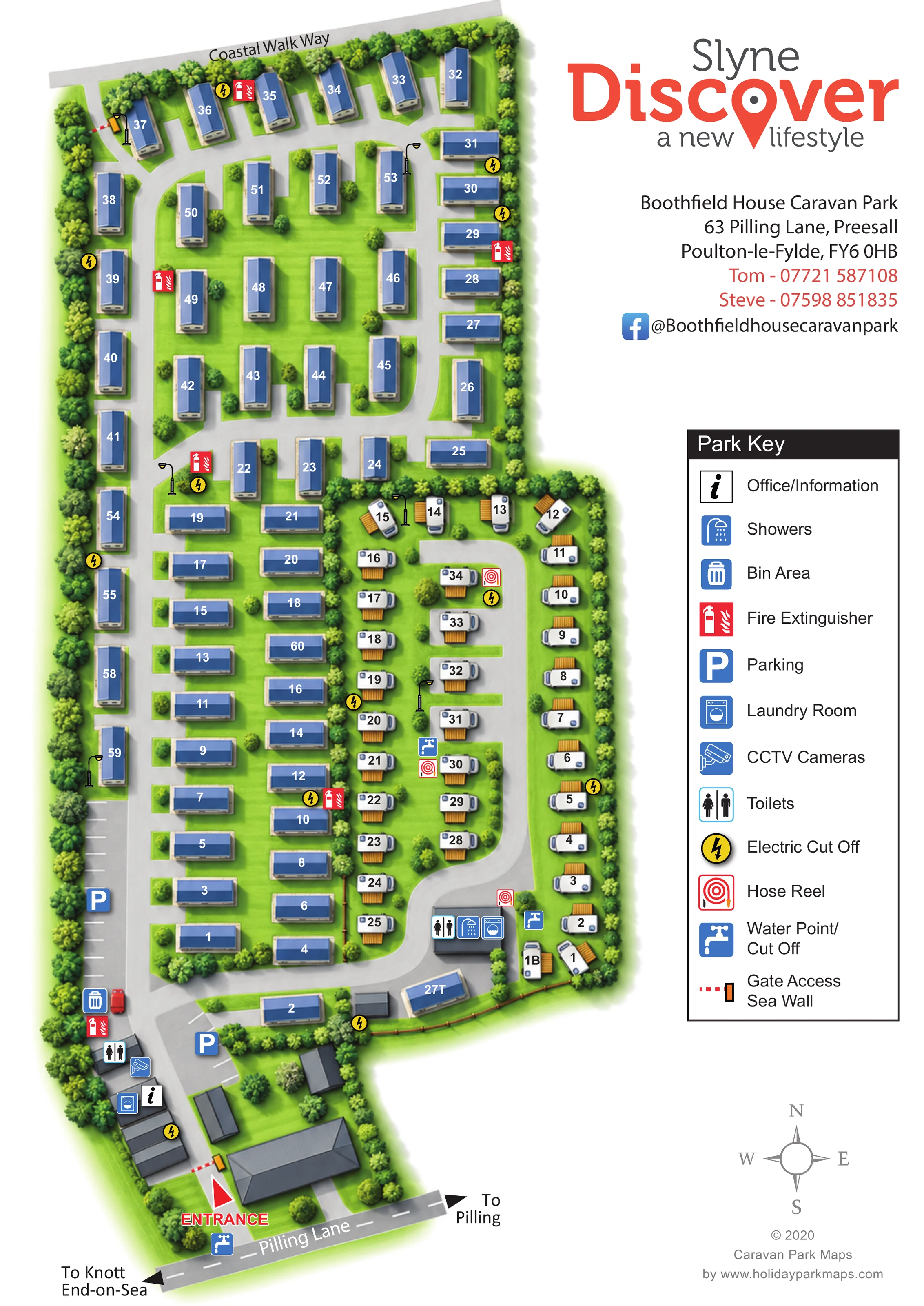
At the north-west corner, a gate symbol indicates access towards the sea wall and coastal walkway. Pilling Lane's two direction arrows name Pilling and Knott End-on-Sea. The tall right-hand key explains the full symbol system beneath the park's branding and contact details, with a compass below. The enlarged detail view shows this same legend and adjoining touring pitches more clearly; it is not a separate map or additional accommodation area.
 Enlarge this map ↗
KEEP EXPLORING
Chosen for shared landscapes, accommodation or facilities.
 Explore the map ↗
United Kingdom
Coastal park map with static-caravan rows, touring pitches, a camping field and two leisure clusters.
 Explore the map ↗
United Kingdom
Coastal park plan with colour-coded pitches, named neighbourhoods and a Morecambe Bay walking route.
 Explore the map ↗
United Kingdom
Illustrated touring-park plan with facilities, public footpaths and adjoining field-access details.
Features may come from the sample artwork, its key or published park information. Approximate numbers describe the drawing and may cover only part of a park. They are intended to help you compare map examples. Current facilities and booking information should be checked with the park.
TAKE A CLOSER LOOK
View the illustrated map in detail or choose a file to download. These are sample maps; contact the park for current visitor information.


LET’S MAP YOUR PARK
For a map quotation, find your park and draw a rough boundary around it. The area you select helps us work out the design time and price.
Draw your park for a quote ↗Or talk to our map designers
01751 473136