
Trees and hedged divisions
Dense tree and shrub symbols frame the park, divide accommodation groups and line both external and internal routes.
ILLUSTRATED PARK MAP · P031
Clyro, Hay-on-Wye, Powys · United Kingdom
 Enlarge the map ↗
A SENSE OF THE PLACE
Borders Hideaway sits in a valley on the Welsh side of the River Wye, near Clyro and Hay-on-Wye. It offers holiday homes, touring and camping pitches, and serviced seasonal spaces.
Washrooms and a choice of pitch services support stays in this countryside setting. Hay's bookshops and independent businesses provide a nearby town to explore, while walking, cycling and canoeing feature among the activities described for the surrounding area.
LOOK CLOSER
Dense tree and shrub symbols frame the park, divide accommodation groups and line both external and internal routes.
Broad grassy spaces contrast with the more tightly arranged accommodation rows, particularly in the western camping field and upper section D.
A black dog silhouette appears in the upper grassy area. It is not explained in the key and should not be treated as a statement of pet policy or a formally designated dog facility.
An information symbol marks the central junction just inside the roadside entrance.
A green recycling symbol sits beside the reception marker at the main internal junction.
Washroom, ladies and gents symbols are grouped at the small service building between sections B and C.
A grey waste water symbol marks the service cluster beside the southern pitch loop.
A blue washing-machine symbol identifies a small building near the junction of the central accommodation lanes and the upper grassy area.
An information symbol marks the central junction just inside the roadside entrance.
A green recycling symbol sits beside the reception marker at the main internal junction.
Washroom, ladies and gents symbols are grouped at the small service building between sections B and C.
A grey waste water symbol marks the service cluster beside the southern pitch loop.
A blue washing-machine symbol identifies a small building near the junction of the central accommodation lanes and the upper grassy area.
A labelled play area with illustrated swings and a slide occupies the centre of the southern loop in section C.
Picnic-table illustrations are scattered through the camping field and the green space inside the southern loop.
Included in the park key; a separate position is not clearly identifiable on the main plan.
An Elsan disposal symbol is explained in the key, without a clearly identifiable placement on the plan.
A blue parking symbol appears in the key; no distinct matching location is evident.
The key includes a house symbol for wardens' accommodation, but the illustrated buildings are not individually labelled with it.
A pool-table pictogram represents a games lounge in the key; its position is not clearly marked.
A green muster-point symbol is supplied in the key, without an identifiable corresponding marker on the plan.
Dense tree and shrub symbols frame the park, divide accommodation groups and line both external and internal routes.
Broad grassy spaces contrast with the more tightly arranged accommodation rows, particularly in the western camping field and upper section D.
A black dog silhouette appears in the upper grassy area. It is not explained in the key and should not be treated as a statement of pet policy or a formally designated dog facility.
A large red entrance label and arrow identify access from the road along the south-eastern boundary.
The boundary road is labelled towards Clyro at the upper-right end and Paincastle at the lower end.
Broad white internal routes connect the entrance junction, eastern roundabout, central accommodation rows, southern pitch loop and small western loop.
READING THE MAP
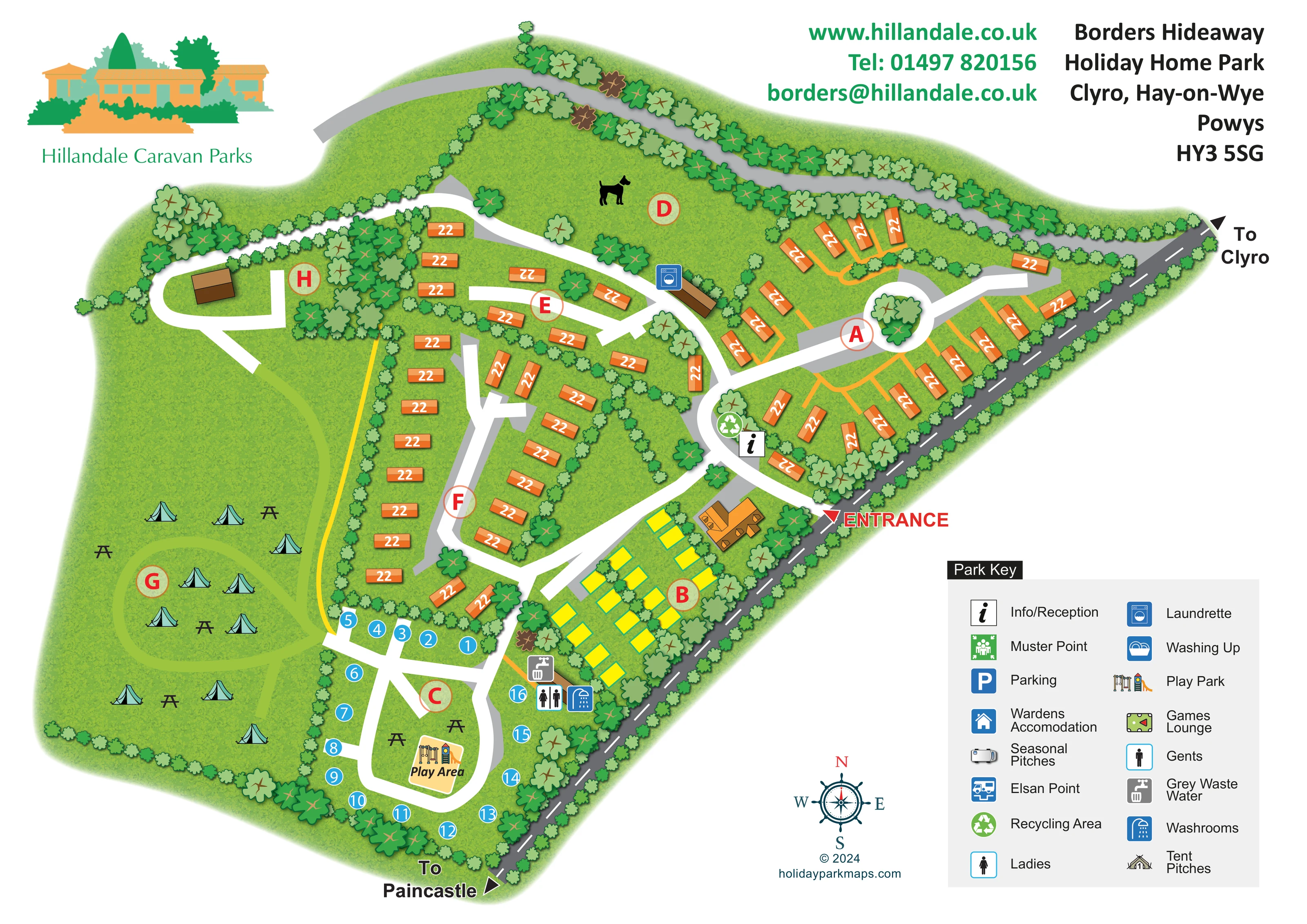
This illustrated map of Borders Hideaway Holiday Home Park brings together holiday-home rows, marked pitch areas and an open camping field in a leafy countryside setting at Clyro, near Hay-on-Wye. Its irregular outline follows a roadside boundary, with trees and hedges used throughout the drawing to separate the different parts of the park.
The main entrance is picked out in red, while broad white lanes lead visitors towards the accommodation areas, reception marker and southern play area. Orange holiday homes, yellow pitch rectangles and blue numbered positions give the accommodation groups distinct visual identities. On the western side, turquoise tents and picnic tables communicate the more open character of the camping field without presenting it as a rigid grid of plots.
Hillandale branding, contact details and a generous two-column key sit around the plan rather than over its busiest areas. The result is a useful sample for countryside parks that need to explain several accommodation zones, shared facilities and a branching internal route network on a single illustrated page.
The plan is organised around a diagonal external road running along the south-eastern edge, with directions towards Clyro and Paincastle. A red entrance arrow leads into a central junction, where information/reception and recycling symbols form an immediate orientation point. From here, the white internal lanes branch towards the eastern accommodation cluster, the central rows and the southern pitch loop.
Orange holiday-home rectangles occupy much of sections A, E and F. Their changing angles follow the lanes and planting rather than imposing a uniform grid. A small roundabout with a planted centre provides a distinctive landmark in the eastern section. Yellow pitch rectangles occupy section B beside the roadside building, while blue numbered circles follow the perimeter of section C. Within that southern loop, a labelled play area contains illustrated play equipment, with picnic tables nearby.
The western field, section G, is more spacious. Tent and picnic-table illustrations establish its camping character, and a pale green curved track suggests movement through the grass. Above it, a small loop reaches an unlabelled building in section H. Section D is an open green area carrying a dog silhouette, although the symbol's meaning is not explained.
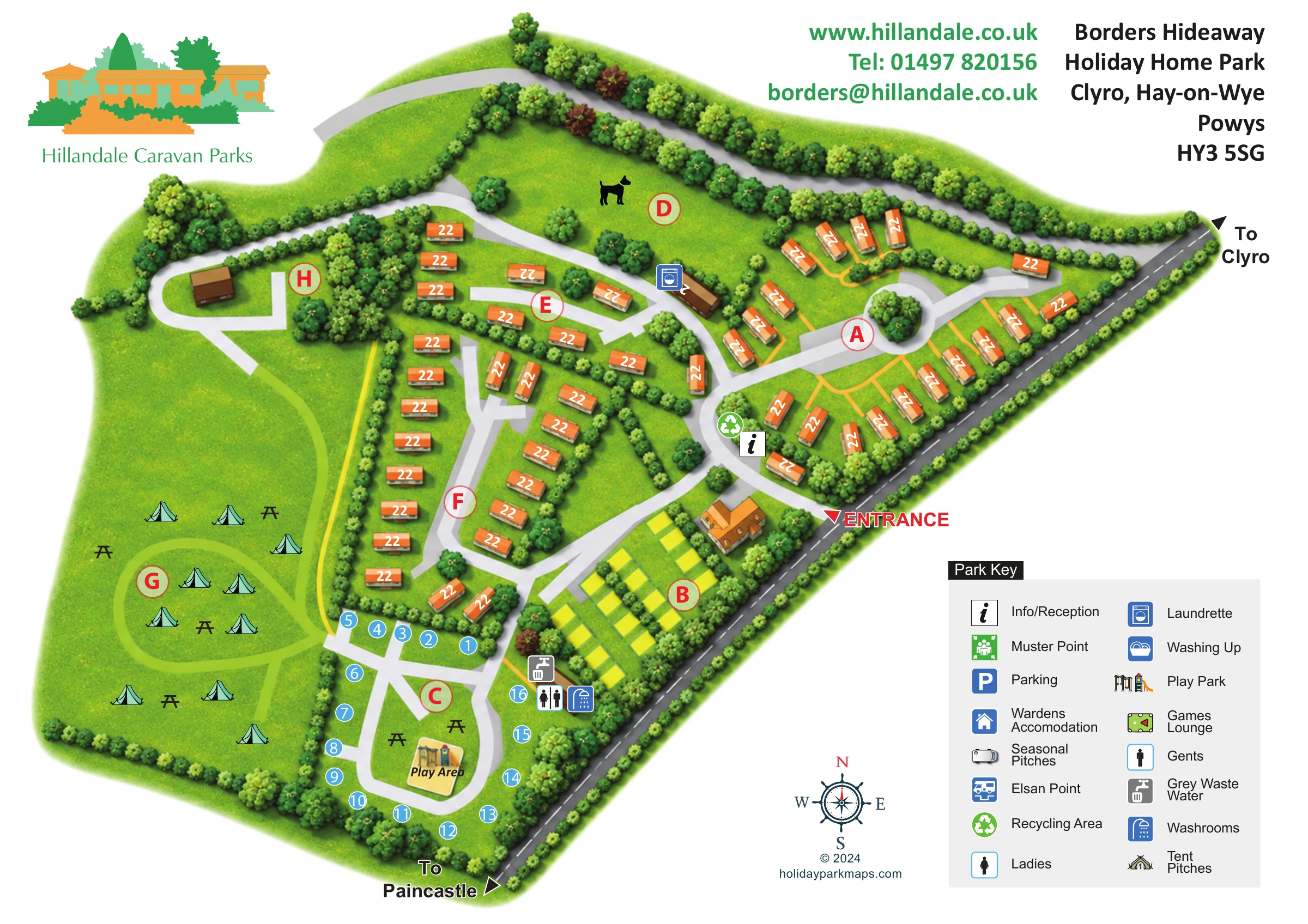
Mapped service symbols include washrooms, ladies and gents, grey waste water and a laundrette. The lower-right key also explains additional symbols whose locations are not clearly shown. Textured grass, dense shrub borders and varied tree crowns make the landscape structure prominent, while red section badges and contrasting pitch markers carry the practical information. The accompanying enlargement shows the same entrance and key in greater detail; it is not a separate park section or an additional map variant.
 Enlarge this map ↗
KEEP EXPLORING
Chosen for shared landscapes, accommodation or facilities.
 Explore the map ↗
United Kingdom
Woodland-framed Barnsoul map with mixed accommodation, shared facilities and paw-marked walking routes.
 Explore the map ↗
United Kingdom
A colour-zoned coastal park map with touring areas, woodland trails, ponds and a leisure club.
 Explore the map ↗
United Kingdom
Tree-framed mixed-accommodation park map with two entrances, touring loops and a clearly illustrated social hub.
Features may come from the sample artwork, its key or published park information. Approximate numbers describe the drawing and may cover only part of a park. They are intended to help you compare map examples. Current facilities and booking information should be checked with the park.
The park postcode is HR3 5SG. The illustrated sample shows an older address label.
LET’S MAP YOUR PARK
For a map quotation, find your park and draw a rough boundary around it. The area you select helps us work out the design time and price.
Draw your park for a quote ↗Or talk to our map designers
01751 473136