
Grazing field
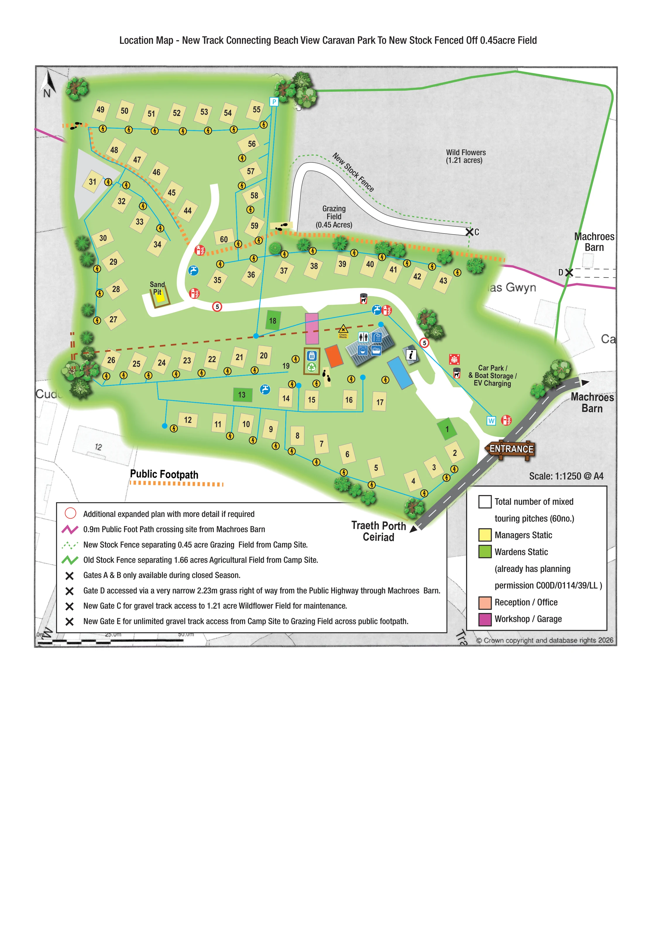
An adjacent grazing field is labelled immediately north-east of the touring area, beside the curved access track.
ILLUSTRATED PARK MAP · P019
Bwlchtocyn, Abersoch, Gwynedd, Wales · United Kingdom
 Enlarge the map ↗
A SENSE OF THE PLACE
Beach View Caravan Park is based at Bwlchtocyn, Abersoch, Gwynedd, Wales. The park occupies a coastal setting on the Llyn Peninsula, within walking distance of the beach. Short stays accept caravans, motorhomes, campervans, tents and trailer tents on pitches described as fully serviced.
Laundry and free showers/washrooms are available.
LOOK CLOSER
An adjacent grazing field is labelled immediately north-east of the touring area, beside the curved access track.
A larger neighbouring field labelled 'Wild Flowers' occupies much of the upper-right part of the plan.
Illustrated trees and shrubs frame the touring area, punctuate corners and line the edge adjoining the fields.
An orange building footprint in the central service cluster corresponds to the reception / office colour key.
A magenta rectangular footprint beside the central service buildings is identified by the building legend as workshop / garage.
Toilet and shower pictograms sit on the grey-roofed central amenities building.
A washing-machine symbol and a basin-style washing-up symbol are grouped with the central amenities building.
A yellow warning-style marker labelled 'Chem. Waste' appears beside the amenities building.
An orange building footprint in the central service cluster corresponds to the reception / office colour key.
A magenta rectangular footprint beside the central service buildings is identified by the building legend as workshop / garage.
Toilet and shower pictograms sit on the grey-roofed central amenities building.
A washing-machine symbol and a basin-style washing-up symbol are grouped with the central amenities building.
A yellow warning-style marker labelled 'Chem. Waste' appears beside the amenities building.
Bin and recycling pictograms mark a dedicated area beside reception and the workshop.
Blue tap symbols are distributed through the pitch areas and near the central facilities.
Repeated yellow lightning-bolt circles accompany the pitches; thin cyan service lines connect the pitch groups.
A large labelled area east of the service cluster combines car parking, boat storage and EV charging near the entrance.
A small yellow, brown-edged sand pit is labelled beside a short branch of the internal lane.
A black information 'i' on a white panel marks a small roofed structure near the arrival and amenities area.
Repeated red extinguisher-style symbols identify fire-point locations around the internal lanes and entrance area.
Dog pictograms on bin symbols appear beside the central lane and the parking area. These symbols do not establish a wider pet policy.
A red people-and-arrows pictogram appears alongside the parking and boat-storage area.
An adjacent grazing field is labelled immediately north-east of the touring area, beside the curved access track.
A larger neighbouring field labelled 'Wild Flowers' occupies much of the upper-right part of the plan.
Illustrated trees and shrubs frame the touring area, punctuate corners and line the edge adjoining the fields.
A prominent timber-sign illustration marks the entrance from the grey public road on the south-eastern edge.
Broad white lanes lead from the entrance past the central facilities, curve westwards and branch into the northern pitch area.
Orange dotted footpath markings with footprint symbols cross the site and follow the field edge. A magenta line identifies the public-footpath connection from Machroes Barn.
The heading and technical notes describe a new gravel-track connection between the campsite and neighbouring fields. A curved white track, lettered gate markers and access notes form a substantial part of the plan.
Solid and dotted green lines distinguish old and new stock-fence boundaries around the adjoining fields.
A road-end arrow points towards Traeth Porth Ceiriad. The beach itself is outside the depicted area.
Machroes Barn is named beside the neighbouring highway and footpath access, providing local context rather than identifying park accommodation.
READING THE MAP
This map of Beach View Caravan Park at Bwlchtocyn, near Abersoch, combines a touring-park layout with a detailed explanation of access to neighbouring fields. Its coastal context is established through a directional label towards Traeth Porth Ceiriad, while the main drawing concentrates on the pitches, arrival area and routes through the site.
Roughly 60 mixed touring pitches are represented by simple numbered blocks on a green ground, framed by illustrated trees and shrubs. White internal lanes lead from a prominent entrance sign to the central amenities, with parking, boat storage and EV charging labelled nearby. Water taps, electrical hook-ups, fire points and waste facilities are shown through compact symbols, and a small sand pit adds a recognisable leisure feature.
The unusual element is the planning layer: grazing and wildflower fields, stock fences, public footpaths, lettered gates and a curved field-access track share the page with visitor information. This makes the sample particularly relevant to parks needing one drawing to explain both their everyday layout and the relationship between visitor areas, surrounding land and proposed access works.
The plan is arranged around a coloured touring area in the lower-left and centre, with neighbouring fields extending across the upper-right. A dark-grey public road follows the south-eastern boundary, where a timber-style entrance sign marks the turn into the park. The arrival lane passes the labelled car park, boat-storage and EV-charging area before reaching a compact group of service buildings.
The central amenities building is illustrated with a shaded grey roof and toilet, shower, laundry and washing-up pictograms. Nearby are a chemical-waste marker, refuse and recycling symbols, an information marker, and colour-coded reception and workshop footprints. Blue tap symbols and red fire-point symbols recur along the lanes; yellow electrical symbols and fine cyan lines accompany the pitch groups. Dog-waste bins and an assembly-point symbol are also drawn near the central and arrival areas.
Cream numbered rectangles form perimeter rows and shorter internal bands. Broad white lanes curve between them, with a short branch beside the labelled sand pit. Green blocks distinguish staff static positions. Trees and shrubs soften the edges without obscuring the basic pitch arrangement.
Beyond the touring area, the drawing gives considerable space to grazing and wildflower land. A curved track, green fence lines, lettered gate markers and public-footpath overlays explain how these areas relate to the campsite and Machroes Barn. Orange dotted paths with footprint motifs contrast with the magenta technical footpath line. The beach is represented by a direction arrow towards Traeth Porth Ceiriad rather than a coastal illustration.
A north arrow, scale bar, stated print scale and two boxed keys complete the single-page composition. The overall design is a site plan with illustrative accents, retaining the neighbouring base-map detail needed to understand the access proposal.
KEEP EXPLORING
Chosen for shared landscapes, accommodation or facilities.
 Explore the map ↗
United Kingdom
Coastal park map with static-caravan rows, touring pitches, a camping field and two leisure clusters.
 Explore the map ↗
United Kingdom
Tree-framed mixed-accommodation park map with two entrances, touring loops and a clearly illustrated social hub.
 Explore the map ↗
United Kingdom
Colour-coded accommodation, central leisure facilities and coastal paths on an illustrated headland park map.
Features may come from the sample artwork, its key or published park information. Approximate numbers describe the drawing and may cover only part of a park. They are intended to help you compare map examples. Current facilities and booking information should be checked with the park.
TAKE A CLOSER LOOK
View the illustrated map in detail or choose a file to download. These are sample maps; contact the park for current visitor information.

LET’S MAP YOUR PARK
For a map quotation, find your park and draw a rough boundary around it. The area you select helps us work out the design time and price.
Draw your park for a quote ↗Or talk to our map designers
01751 473136