
Lawns, hedges and planted boundaries
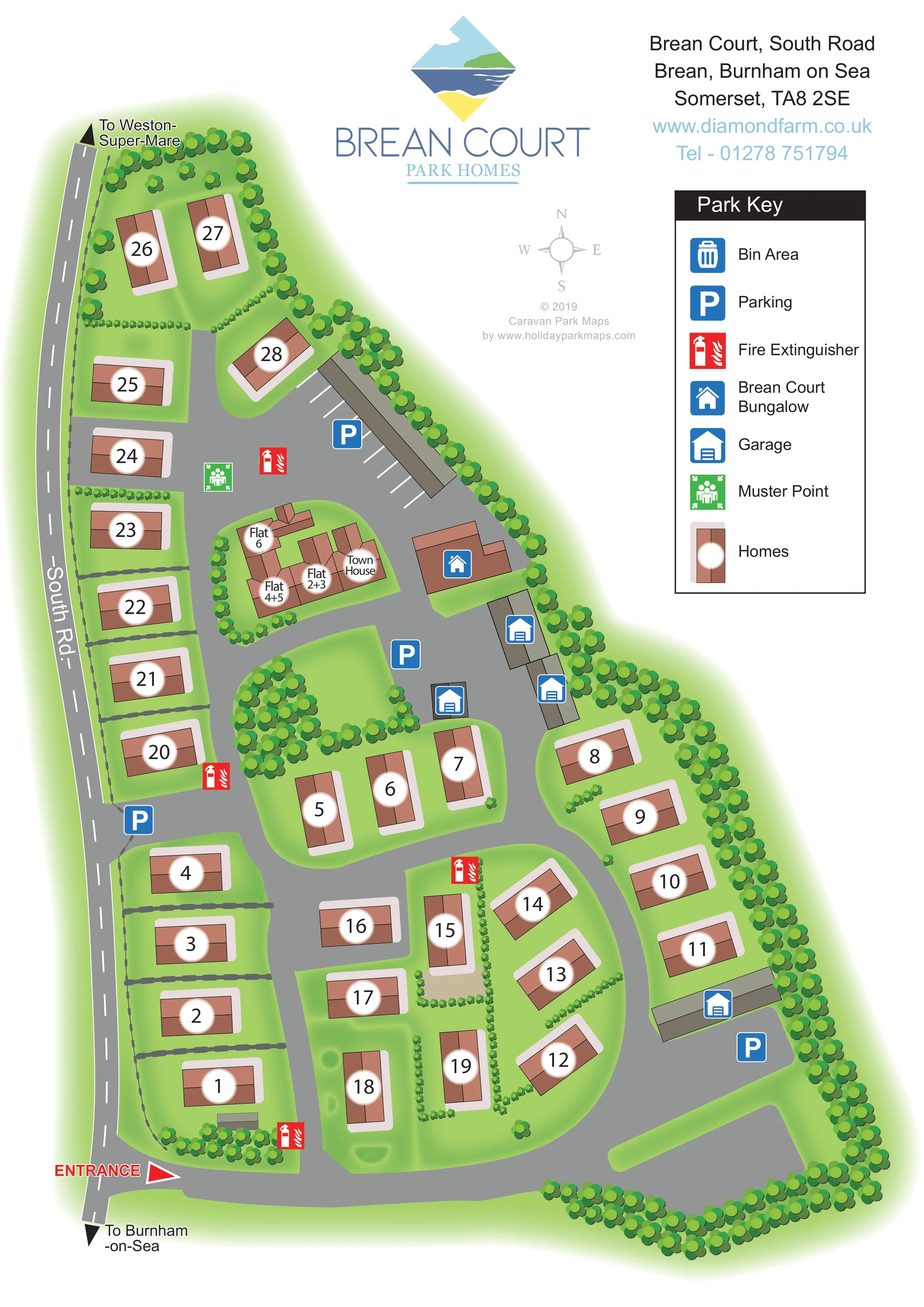
Green plot areas, small hedge symbols and dense tree planting define gardens, residential islands and much of the estate perimeter.
ILLUSTRATED PARK MAP · P416
Brean Court, South Road, Brean, Burnham on Sea, Somerset · United Kingdom
 Enlarge the map ↗
A SENSE OF THE PLACE
Brean Court is a residential park at Brean in Somerset, close to the village's beaches and amenities. Its accommodation includes park-style homes alongside other residential properties.
The operator describes an over-55 community. The map forms part of the residential park collection, showing the arrangement of homes and access routes rather than presenting the estate as bookable holiday accommodation.
LOOK CLOSER
Green plot areas, small hedge symbols and dense tree planting define gardens, residential islands and much of the estate perimeter.
A red arrow and ENTRANCE label mark access from South Road at the lower-left corner.
Black arrows at either end of South Road provide wider geographical orientation.
Broad grey access roads curve around landscaped residential islands and connect to the northern parking courtyard.
Blue P symbols identify parking in several parts of the estate; white bay markings distinguish the northern parking area.
Blue garage symbols identify several grey-roofed buildings beside the internal roads.
A blue house symbol identifies the separate bungalow beside the upper residential building cluster.
Red fire extinguisher symbols are distributed along the estate roads.
A red arrow and ENTRANCE label mark access from South Road at the lower-left corner.
Black arrows at either end of South Road provide wider geographical orientation.
Broad grey access roads curve around landscaped residential islands and connect to the northern parking courtyard.
Blue P symbols identify parking in several parts of the estate; white bay markings distinguish the northern parking area.
Blue garage symbols identify several grey-roofed buildings beside the internal roads.
A blue house symbol identifies the separate bungalow beside the upper residential building cluster.
Red fire extinguisher symbols are distributed along the estate roads.
A green assembly symbol marks a muster point in the northern paved courtyard.
Included in the Park Key, but no corresponding position is clearly identifiable in the main plan.
Green plot areas, small hedge symbols and dense tree planting define gardens, residential islands and much of the estate perimeter.
The operator describes Brean Court as an over-55 residential community; this is contextual information rather than a mapped amenity.
READING THE MAP
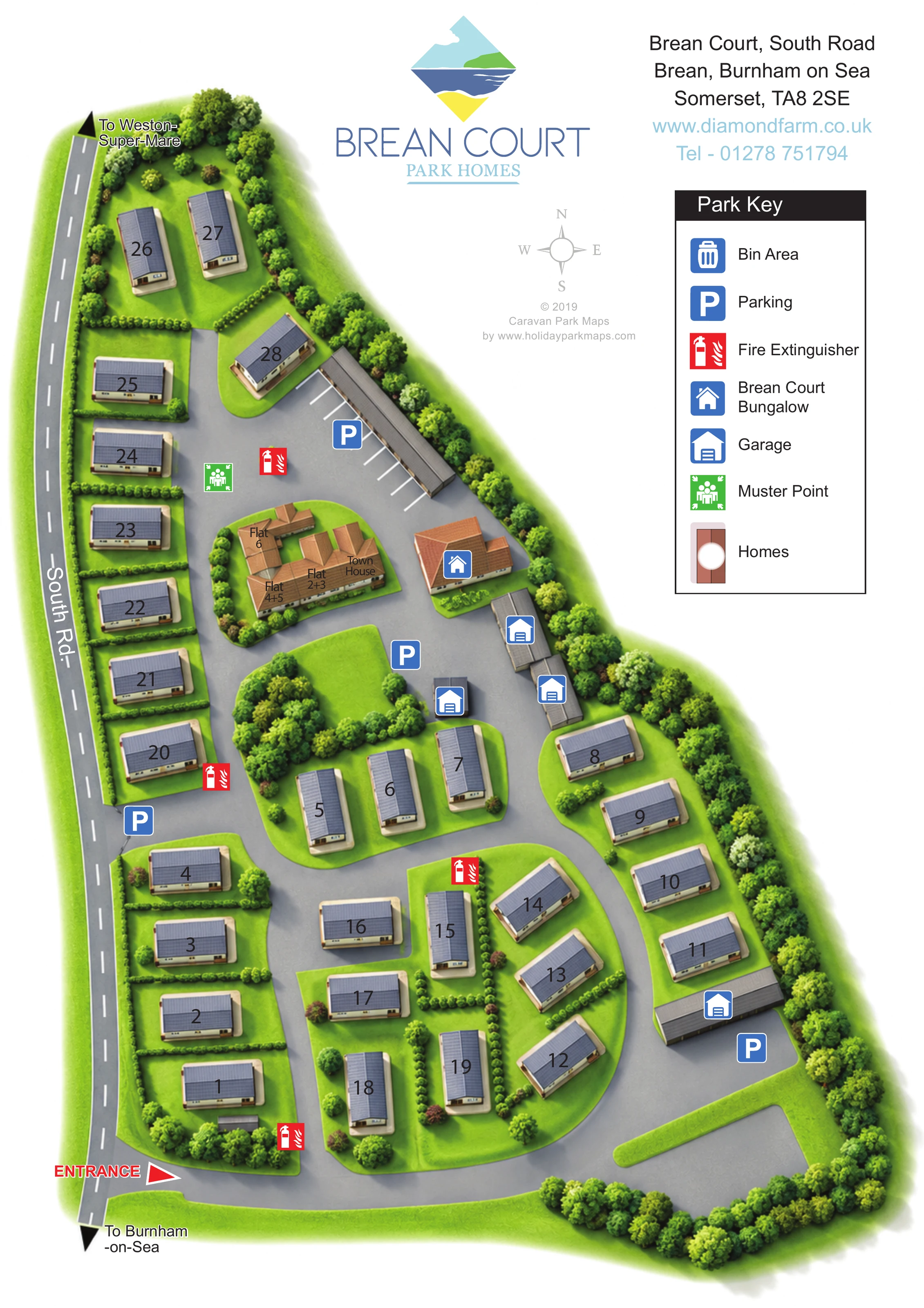
This illustrated map of Brean Court presents a small residential park in Brean, Somerset, with a clear emphasis on finding homes and navigating the estate. South Road runs down the left-hand side, with arrows towards Weston-super-Mare and Burnham-on-Sea giving the plan a useful local frame of reference. A prominent red entrance marker leads into the curved internal road network.
The map shows detached park homes set within green plots, together with a compact group of flats, a town house and the separately identified Brean Court Bungalow. Warm roof colours and large white number discs make the homes easy to distinguish from grey garages and paved areas. Trees and hedges describe the planted boundaries and the divisions between residential spaces.
Parking, fire extinguisher points and a muster point are picked out with bold symbols, explained in a substantial right-hand key. The portrait page also accommodates the park’s coastal-themed branding and contact details, making this a useful example of a residential estate plan that combines property identification with practical orientation.
The plan follows Brean Court’s elongated shape beside South Road, beginning with the entrance at the lower-left corner and extending northwards to a smaller group of homes and a paved parking courtyard. Broad grey estate roads curve around green residential islands, with detached homes arranged both along the road frontage and in angled rows inside the park. Large black numbers on white discs provide the principal property references.
The upper-middle part of the estate contains a more varied building group. Flats and a town house are labelled directly over their connected terracotta roof shapes, while a blue house icon identifies Brean Court Bungalow nearby. Grey garage buildings are marked with separate blue symbols. Parking is indicated at several locations, and the northern courtyard includes drawn bay lines beside a long grey building.
The landscape illustration gives the plan much of its character. Dense clusters of rounded trees follow the eastern and southern perimeter, while smaller hedge chains divide individual gardens and outline the central building group. Soft green shading adds depth to lawns without obscuring roads or labels.
Red fire extinguisher icons and a green muster-point symbol stand apart from the blue property and parking markers. The upper-right Park Key explains these symbols and includes a bin-area entry, although a bin location is not clearly marked on the main plan. Above the estate, the Brean Court Park Homes logo, address block and compass occupy open white space. South Road’s destination arrows provide additional orientation. The accompanying enlarged image is a closer view of the same key and adjacent homes, not a separate estate section.
 Enlarge this map ↗
KEEP EXPLORING
Chosen for shared landscapes, accommodation or facilities.
 Explore the map ↗
United Kingdom
Illustrated Sanday aire map with a seasonal maze, café barn and motorhome service area.
 Explore the map ↗
United Kingdom
Illustrated coastal campsite plan with named fields, electric pitch colours, beach routes and the Afon Hen.
 Explore the map ↗
United Kingdom
A woodland touring-park map with colour-coded pitches, a stream and footprint-marked walks.
Features may come from the sample artwork, its key or published park information. Approximate numbers describe the drawing and may cover only part of a park. They are intended to help you compare map examples. Current facilities and booking information should be checked with the park.
TAKE A CLOSER LOOK
View the illustrated map in detail or choose a file to download. These are sample maps; contact the park for current visitor information.


LET’S MAP YOUR PARK
For a map quotation, find your park and draw a rough boundary around it. The area you select helps us work out the design time and price.
Draw your park for a quote ↗Or talk to our map designers
01751 473136