
Bodham Wood
Bodham Wood is named along the densely illustrated tree belt at the right-hand edge of the plan.
ILLUSTRATED PARK MAP · P033
Breck Farm Camping and Caravanning, Weybourne, Holt · United Kingdom
 Enlarge the map ↗
A SENSE OF THE PLACE
Breck Farm is a long-established working farm and campsite near Weybourne and Holt in North Norfolk. Its accommodation includes camping, glamping and holiday lets, with several camping fields offering different settings and electric options.
A campsite shop, shower and toilet block and adventure playground support family stays. Campfires are permitted in designated fields, and visiting food vans add options during some school holidays. The farm's livestock and crops remain part of the setting.
LOOK CLOSER
Bodham Wood is named along the densely illustrated tree belt at the right-hand edge of the plan.
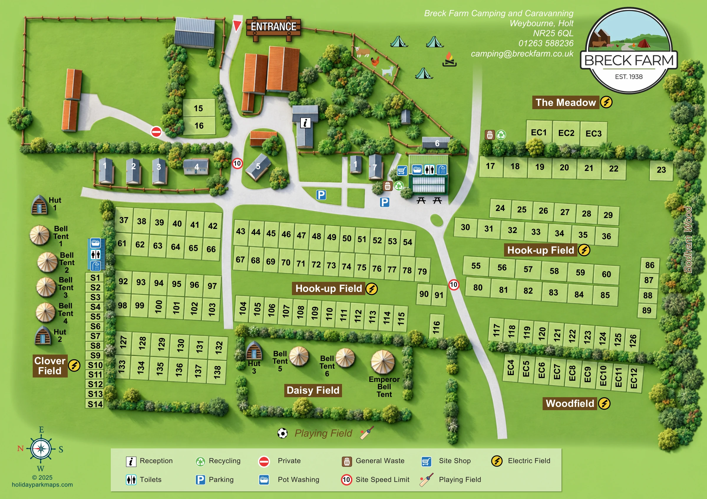
Continuous hedges separate pitch groups, frame Daisy Field and divide camping areas from the farm buildings. Larger tree clusters enrich the arrival area and woodland boundary.
Orange- and grey-roofed agricultural buildings, timber fences and livestock illustrations establish the working-farm setting around the entrance. The animals are pictorial context rather than a labelled visitor attraction.
A flame-and-logs symbol appears beside the decorative tents in the upper open field. It is not keyed as a designated fire point or a permission boundary.
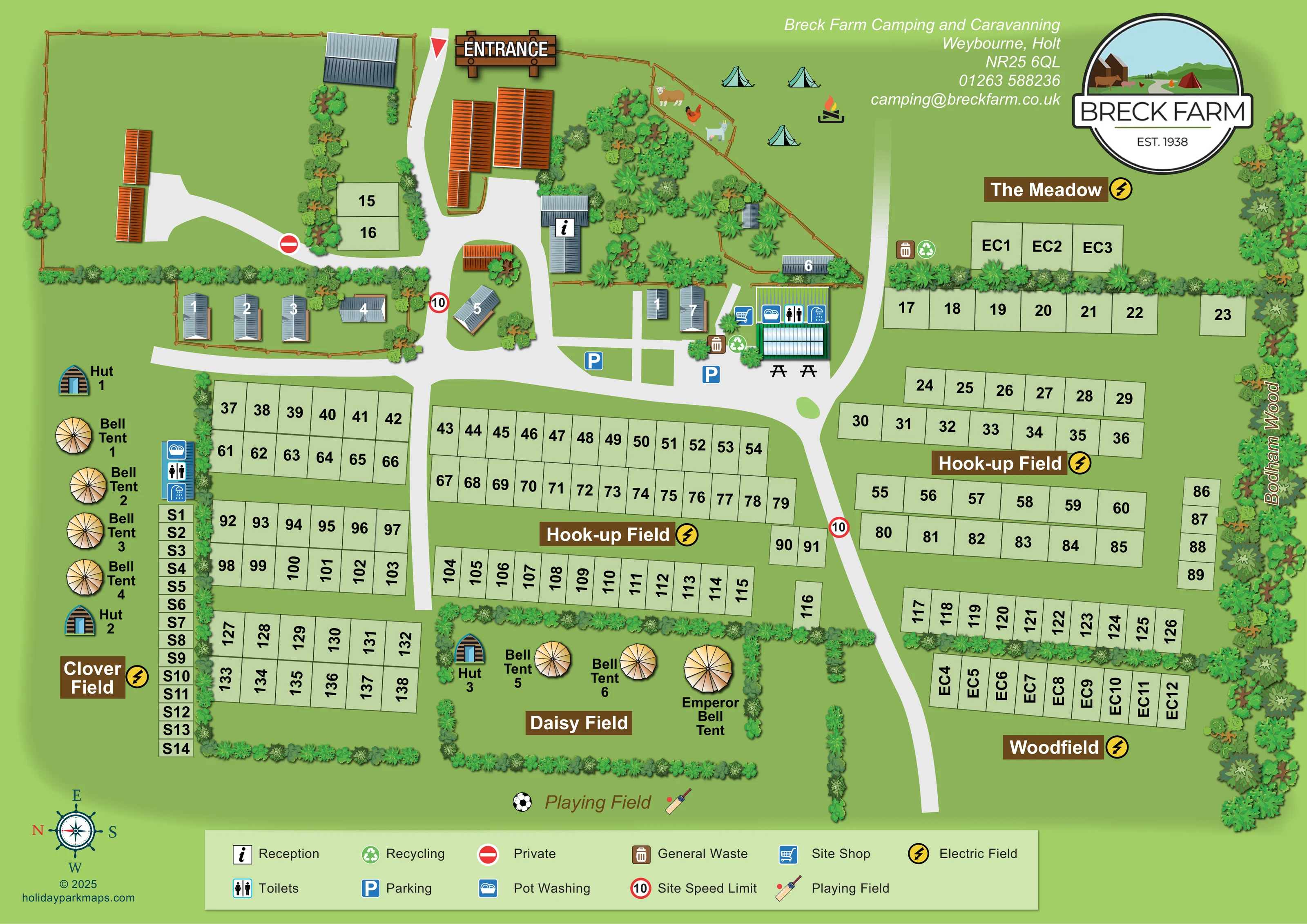
An information symbol identifies reception in a grey-roofed building just inside the entrance, beside the main internal junction.
A shopping-trolley symbol marks the shop at the central service building.
Grouped toilet, shower and pot-washing symbols appear at the central service building and beside the western glamping and pitch areas. Shower symbols are shown on the plan although not explained in the bottom legend.
Paired waste and recycling markers are shown near the central facilities and beside the approach to The Meadow.
An information symbol identifies reception in a grey-roofed building just inside the entrance, beside the main internal junction.
A shopping-trolley symbol marks the shop at the central service building.
Grouped toilet, shower and pot-washing symbols appear at the central service building and beside the western glamping and pitch areas. Shower symbols are shown on the plan although not explained in the bottom legend.
Paired waste and recycling markers are shown near the central facilities and beside the approach to The Meadow.
Blue parking symbols identify spaces around the central arrival and facilities area.
Yellow lightning-bolt symbols accompany The Meadow, Hook-up Field, Clover Field and Woodfield, linking named areas to the legend's Electric Field category.
Two picnic-table illustrations sit immediately outside the central service building.
An open area below Daisy Field is labelled Playing Field and illustrated with a football and cricket equipment.
Bodham Wood is named along the densely illustrated tree belt at the right-hand edge of the plan.
Continuous hedges separate pitch groups, frame Daisy Field and divide camping areas from the farm buildings. Larger tree clusters enrich the arrival area and woodland boundary.
Orange- and grey-roofed agricultural buildings, timber fences and livestock illustrations establish the working-farm setting around the entrance. The animals are pictorial context rather than a labelled visitor attraction.
A flame-and-logs symbol appears beside the decorative tents in the upper open field. It is not keyed as a designated fire point or a permission boundary.
A large timber-style ENTRANCE sign and red directional arrow mark arrival from the upper edge.
Broad pale roads connect the entrance, reception and central facilities, then branch between pitch areas and curve down towards Woodfield.
A red no-entry-style symbol, defined as Private in the legend, marks the branch leading into the upper-left farm compound.
Circular signs bearing 10 appear on the internal routes and are identified as Site Speed Limit in the legend.
An adventure playground is mentioned in the wider park information but is not explicitly located or labelled on this plan.
READING THE MAP
This illustrated map of Breck Farm Camping and Caravanning brings together a working-farm setting, organised camping fields and small glamping areas near Weybourne and Holt in North Norfolk. Rather than treating the campsite as a single grid, the design gives each part its own identity: The Meadow, Hook-up Field, Clover Field, Daisy Field and Woodfield are separated by roads, hedges and clear field-name panels.
The entrance leads through a cluster of farm buildings towards reception and the central facilities. From there, pale access roads guide the eye into the numbered pitch areas, while blue symbols identify parking, the shop and washing facilities. Bell tents and timber huts are drawn individually, making their locations easy to distinguish from the rectangular camping and caravanning pitches.
Bodham Wood forms a leafy edge to the right of the plan, and a playing field sits below the glamping area. Livestock illustrations, warm roof colours and timber-style signs preserve the character of the farm. The result is a practical example of campsite mapping that combines pitch-level navigation with a recognisable rural setting.
The plan is arranged around an entrance at the upper edge, marked by a red arrow and a large timber-style sign. Broad pale roads pass the agricultural buildings and reception before branching into the campsite. A private-access marker distinguishes the route into the upper-left farm compound from the visitor circulation network.
Most accommodation space is represented by pale-green rectangular pitches with bold black references. These form parallel rows and paired blocks across the central and eastern Hook-up Field areas, with further groups in Clover Field, The Meadow and Woodfield. Yellow lightning-bolt markers identify the electric fields. Hedgerows divide the blocks without obscuring their references, and the main road curves between the central pitches and the eastern woodland-side areas.
Glamping receives a different visual treatment. Cream bell-tent canopies and timber hut illustrations run down the western side, while Daisy Field contains another small group, including the larger Emperor Bell Tent. Near the entrance, numbered grey-roofed structures are illustrated individually, although their accommodation type is not explained by the key.
The principal service building combines shop, pot-washing, toilet and shower symbols, with parking, waste and recycling nearby. Another washing-facility cluster serves the western side. Picnic tables are drawn outside the main block. Below Daisy Field, the Playing Field label is accompanied by football and cricket illustrations; Bodham Wood is named along the dense right-hand tree belt.
A large farm badge and contact block occupy the upper-right corner. The two-row legend anchors the bottom margin, balanced by a compass rose showing north to the left. The artwork is a single complete plan; the enlarged views repeat its details rather than introducing separate sections or additional accommodation.
 Enlarge this map ↗
KEEP EXPLORING
Chosen for shared landscapes, accommodation or facilities.
 Explore the map ↗
United Kingdom
Woodland-framed Barnsoul map with mixed accommodation, shared facilities and paw-marked walking routes.
 Explore the map ↗
United Kingdom
A colour-zoned coastal park map with touring areas, woodland trails, ponds and a leisure club.
 Explore the map ↗
United Kingdom
Colour-coded accommodation, lakeside facilities and woodland routes at Burton Constable Holiday Park & Arboretum.
Features may come from the sample artwork, its key or published park information. Approximate numbers describe the drawing and may cover only part of a park. They are intended to help you compare map examples. Current facilities and booking information should be checked with the park.
LET’S MAP YOUR PARK
For a map quotation, find your park and draw a rough boundary around it. The area you select helps us work out the design time and price.
Draw your park for a quote ↗Or talk to our map designers
01751 473136