
Bradley Burn
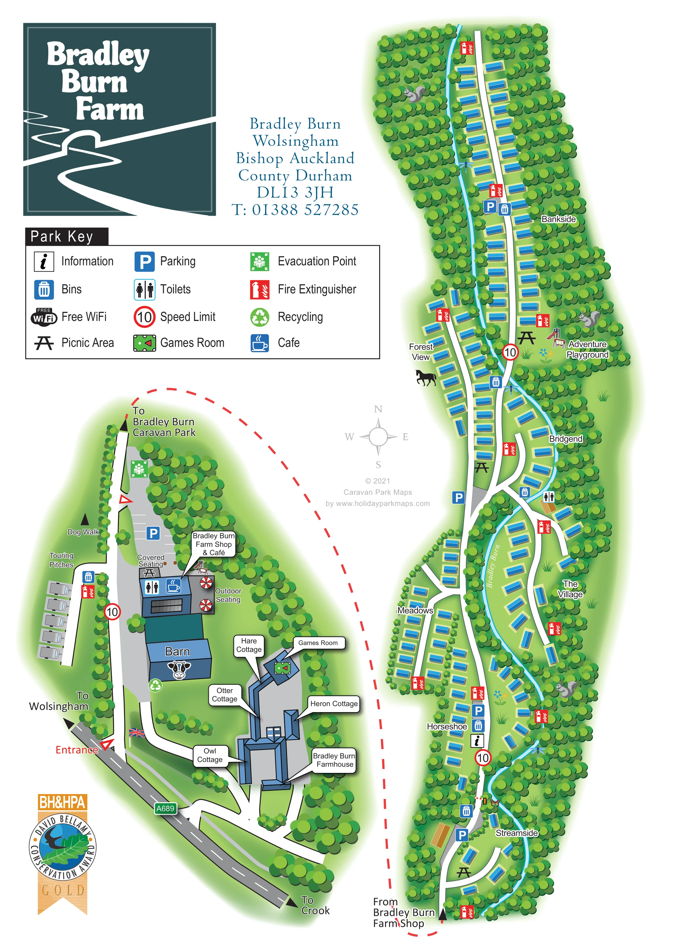
A bright blue stream runs along the elongated main park, curving between accommodation groups and crossing the road network.
ILLUSTRATED PARK MAP · P415
Bradley Burn, Wolsingham, Bishop Auckland, County Durham · United Kingdom
 Enlarge the map ↗
A SENSE OF THE PLACE
Bradley Burn is a holiday home and touring park in a sheltered Weardale valley in County Durham. The burn runs through the grounds, with a farm shop and cafe forming part of the wider farm setting.
Holiday homes and lodges are offered for ownership, alongside a separate certificated touring area for caravans and motorhomes. An adventure playground, communal gardens, showers, laundry and dog-exercise paths support stays.
LOOK CLOSER
A bright blue stream runs along the elongated main park, curving between accommodation groups and crossing the road network.
Dense belts of illustrated trees frame the main park and the farm buildings, with smaller trees and shrubs separating accommodation rows.
A prominent labelled building in the farm-area drawing, beside parking and seating.
Covered seating is labelled beside the café, with parasol tables identifying the outdoor seating area.
Picnic-table symbols appear at several points in the main park, including near the adventure playground and Streamside.
A labelled play area occupies a green clearing near the junction of Bankside, Forest View and Bridgend. A smaller play-equipment illustration also appears beside the café.
A callout and pool-table symbol locate the games room in the farm courtyard beside the cottages.
Toilet symbols identify facilities at the café and within the main caravan park near Bridgend.
A prominent labelled building in the farm-area drawing, beside parking and seating.
Covered seating is labelled beside the café, with parasol tables identifying the outdoor seating area.
Picnic-table symbols appear at several points in the main park, including near the adventure playground and Streamside.
A labelled play area occupies a green clearing near the junction of Bankside, Forest View and Bridgend. A smaller play-equipment illustration also appears beside the café.
A callout and pool-table symbol locate the games room in the farm courtyard beside the cottages.
Toilet symbols identify facilities at the café and within the main caravan park near Bridgend.
Blue parking symbols mark the farm car park and several parking locations along the main park road.
Bin symbols are distributed through both drawings; a recycling symbol is placed beside the barn.
An information symbol appears beside the main road in the Horseshoe area.
Red fire-extinguisher symbols recur throughout the park and beside the touring pitches. A green evacuation-point symbol is shown near the farm parking area.
Free WiFi is included in the key, without a clearly located coverage area or point in the plan.
A directional arrow beside the touring pitches points towards the dog walk.
The farm entrance is marked from the A689, with directions towards Wolsingham and Crook.
A sweeping red dashed connector and paired directional labels explain the relationship between the separated farm and main-park drawings.
Red-ringed 10 signs are shown on the farm approach and at several points along the main park road.
A bright blue stream runs along the elongated main park, curving between accommodation groups and crossing the road network.
Dense belts of illustrated trees frame the main park and the farm buildings, with smaller trees and shrubs separating accommodation rows.
The farm-area drawing identifies a barn and farmhouse alongside the café, games room and cottages.
These are described in the wider park information but are not individually labelled on this artwork.
READING THE MAP
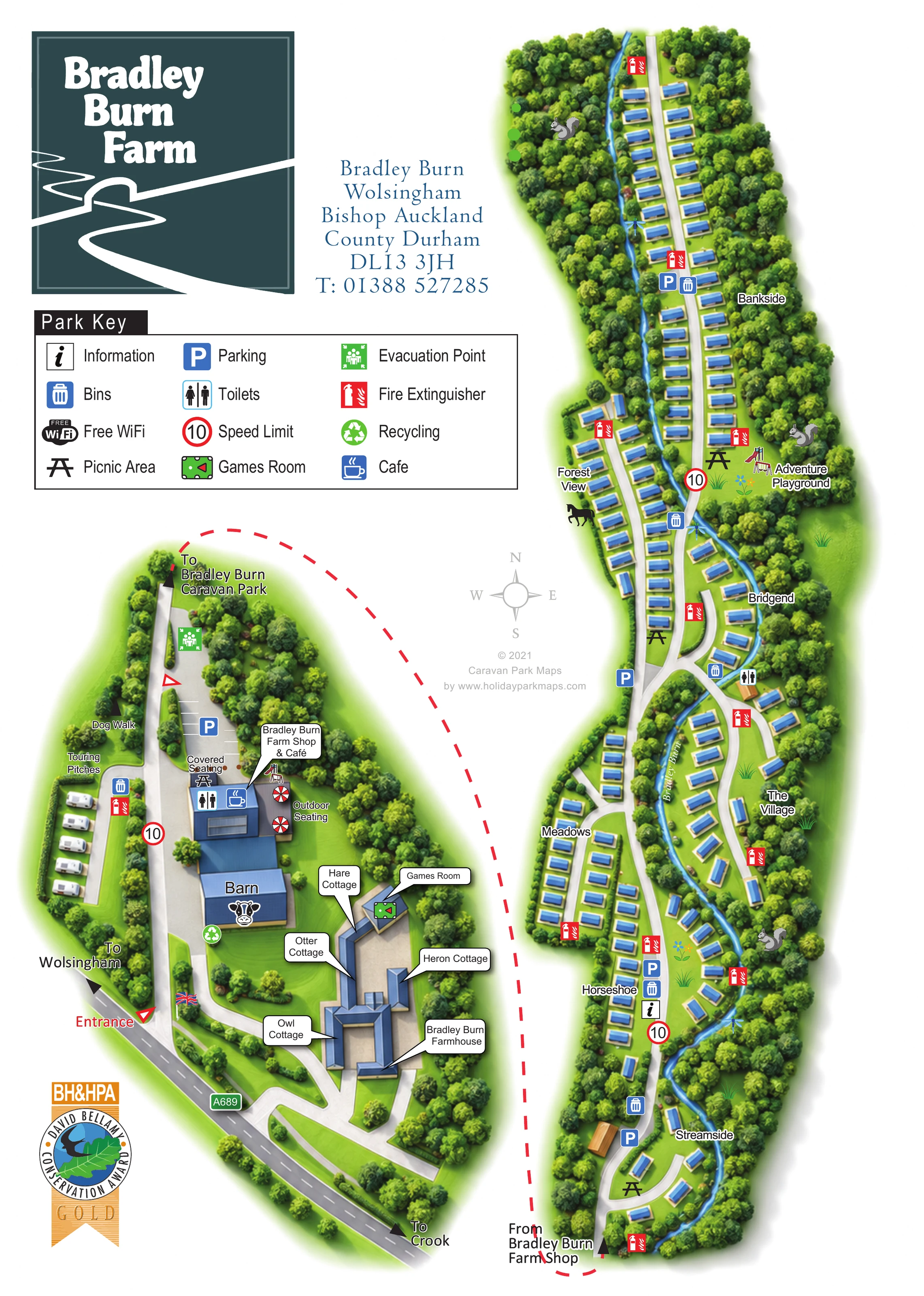
This illustrated map brings together Bradley Burn’s wooded caravan park and its farm-based arrival area in Wolsingham, County Durham. The main park stretches down the right-hand side of the page, following the bright blue course of Bradley Burn through rows of holiday homes and densely planted margins. Seven named areas, including Bankside, Forest View, Horseshoe and Streamside, give visitors useful landmarks along the long internal road.
A separate, enlarged drawing at lower left explains the entrance from the A689 and the cluster of facilities around Bradley Burn Farm. Here the map shows touring pitches, four named cottages, the farmhouse, barn, games room and farm shop and café, together with parking and covered and outdoor seating. A red dashed connector makes the relationship between the two drawings clear without forcing their different shapes into a single cramped plan.
The result is a characterful visitor map with a practical structure: clear routes and recognisable amenity symbols sit alongside trees, water, play equipment and small rural illustrations. The prominent farm branding and generous key give the page a strong identity while keeping everyday orientation straightforward.
The artwork uses one portrait page to show two connected parts of Bradley Burn. On the right, the main holiday-home park is drawn as a long wooded corridor. A white access road runs through Bankside at the northern end, then divides into smaller branches and loops serving Forest View, Bridgend, The Village, Meadows, Horseshoe and Streamside. Blue-roofed accommodation units are arranged beside these lanes, with planting separating rows and soft green shading defining the outer edge.
Bradley Burn is a strong visual organising feature. Its blue course follows and crosses the road network, threading between accommodation groups before curving around the southern end. An adventure playground and picnic area occupy a clearing near the upper-middle junction. Further picnic symbols, parking points, bins, fire extinguishers, an information point and toilets are placed along the main routes. Red-ringed speed markers add another layer of practical orientation.
The lower-left drawing concentrates on arrival and the farm courtyard. The A689 is labelled with directions to Wolsingham and Crook, and the entrance leads towards parking, a small row of touring pitches and a dog-walk direction. Larger illustrated buildings identify the farm shop and café, barn and farmhouse. Pointer labels distinguish Hare, Otter, Heron and Owl Cottages, while a pool-table symbol marks the games room. Covered seating and parasol tables explain the café’s outdoor spaces.
A sweeping dashed red line links this drawing to the main park. Above it, a large three-column key explains the amenity symbols, while the farm logo, contact block, compass and conservation-award badge occupy the remaining white space. The legend enlargement repeats part of this same artwork rather than adding a separate map or site.
 Enlarge this map ↗
KEEP EXPLORING
Chosen for shared landscapes, accommodation or facilities.
 Explore the map ↗
United Kingdom
Mixed-accommodation park map with woodland, public footpaths and clearly differentiated service symbols.
 Explore the map ↗
United Kingdom
Woodland-framed Barnsoul map with mixed accommodation, shared facilities and paw-marked walking routes.
 Explore the map ↗
United Kingdom
Woodland holiday-park map with named accommodation areas, touring loops and illustrated recreation facilities.
Features may come from the sample artwork, its key or published park information. Approximate numbers describe the drawing and may cover only part of a park. They are intended to help you compare map examples. Current facilities and booking information should be checked with the park.
TAKE A CLOSER LOOK
View the illustrated map in detail or choose a file to download. These are sample maps; contact the park for current visitor information.


LET’S MAP YOUR PARK
For a map quotation, find your park and draw a rough boundary around it. The area you select helps us work out the design time and price.
Draw your park for a quote ↗Or talk to our map designers
01751 473136
 bothmaps_Page_2.png