
Tree-lined boundary and planted divisions
Large stylised trees frame the northern, eastern and southern edges; smaller shrubs divide several home plots and line parts of the roadside boundary.
ILLUSTRATED PARK MAP · P417
Middleton Road, Middleton, Lancashire · United Kingdom
 Enlarge the map ↗
A SENSE OF THE PLACE
Broadgate Foot is a residential caravan site in the Middleton and Heysham area of Lancashire. Lancaster City Council's site register confirms the residential identity.
The map is retained as an estate layout example, showing how homes and access routes can be presented together. It carries no unverified holiday accommodation, visitor-facility or current operator claims.
LOOK CLOSER
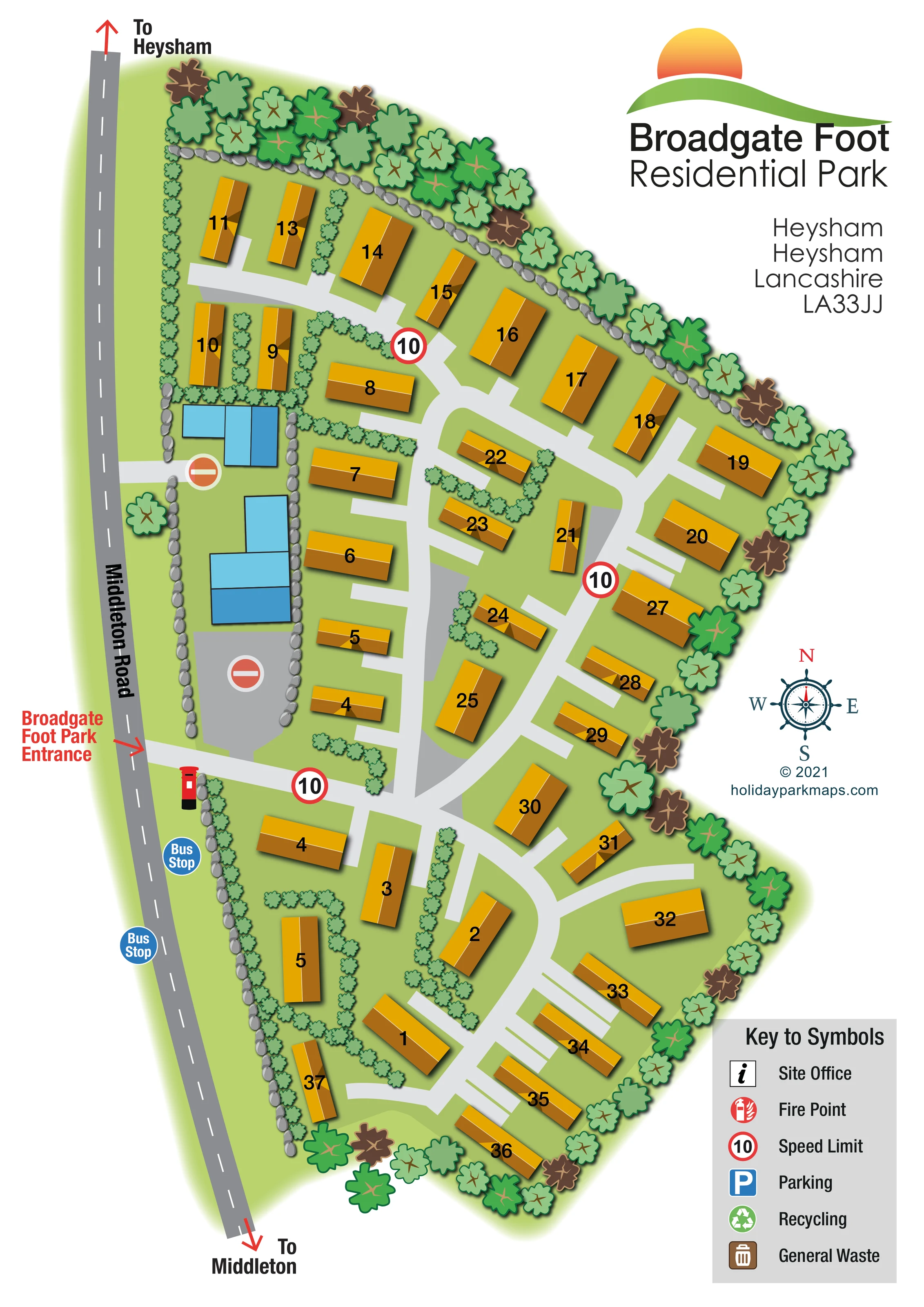
Large stylised trees frame the northern, eastern and southern edges; smaller shrubs divide several home plots and line parts of the roadside boundary.
Rows of grey rounded stones define the upper edge and sections beside Middleton Road and the blue buildings.
A red label and arrow identify the entrance from Middleton Road on the western side, approximately midway down the estate.
The road runs along the left side of the plan, with arrows towards Heysham at the top and Middleton at the bottom.
Pale-grey branching and curving routes connect the entrance to homes throughout the estate, with short individual access spurs.
Two blue Bus Stop markers appear on opposite sides of Middleton Road near and below the entrance.
Red-ringed signs displaying 10 are placed at the entrance route and within the internal road network.
Two no-entry symbols mark access points associated with the blue-building and grey-surfaced area beside Middleton Road.
A red label and arrow identify the entrance from Middleton Road on the western side, approximately midway down the estate.
The road runs along the left side of the plan, with arrows towards Heysham at the top and Middleton at the bottom.
Pale-grey branching and curving routes connect the entrance to homes throughout the estate, with short individual access spurs.
Two blue Bus Stop markers appear on opposite sides of Middleton Road near and below the entrance.
Red-ringed signs displaying 10 are placed at the entrance route and within the internal road network.
Two no-entry symbols mark access points associated with the blue-building and grey-surfaced area beside Middleton Road.
A red fire-point illustration is positioned beside the entrance, just inside the roadside boundary.
Two groups of blue building shapes occupy the western side above the entrance. Their functions are not identified on the plan.
Large stylised trees frame the northern, eastern and southern edges; smaller shrubs divide several home plots and line parts of the roadside boundary.
Rows of grey rounded stones define the upper edge and sections beside Middleton Road and the blue buildings.
An information-style site-office symbol appears in the key, but no matching office location is clearly marked in the estate plan.
The key includes a blue parking symbol; no corresponding marked parking location is clearly visible on the plan.
A green recycling symbol is included in the key without a clearly identifiable mapped position.
A brown waste-bin symbol appears in the key without a clearly identifiable mapped position.
READING THE MAP
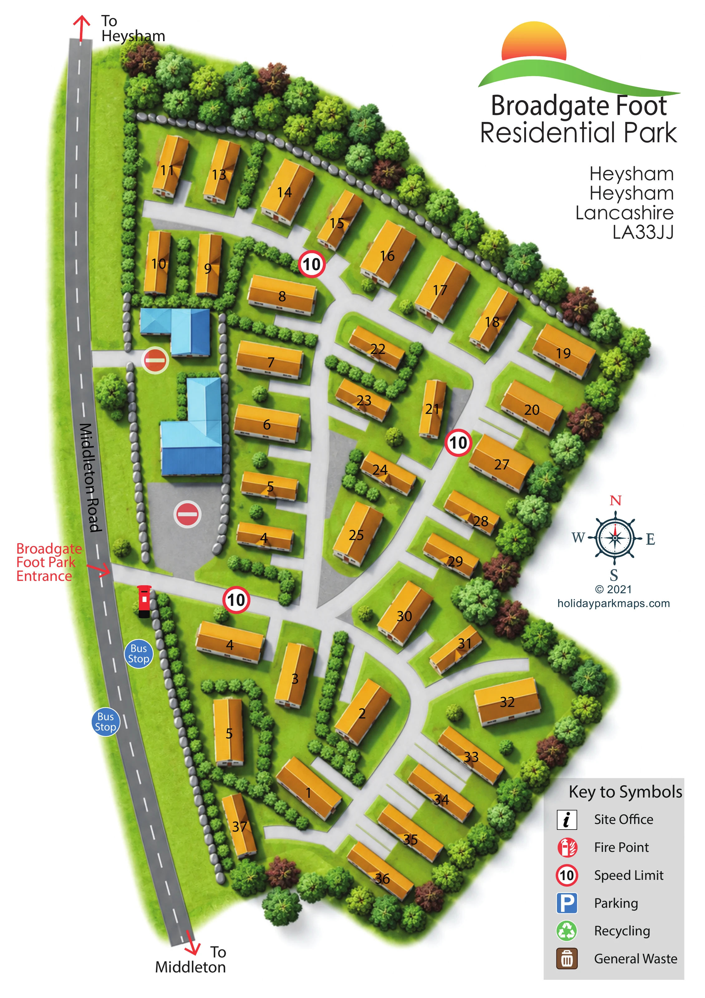
This illustrated map of Broadgate Foot Residential Park presents a compact residential estate beside Middleton Road in the Middleton and Heysham area of Lancashire. Rather than depicting holiday pitches or leisure attractions, it focuses on the relationship between numbered homes, internal access routes and the adjoining public road. Around 35 gold-coloured home symbols give a broad impression of the estate’s scale, with planted divisions and a tree-lined perimeter helping readers recognise its shape.
The entrance is highlighted in red, while arrows towards Heysham and Middleton establish the wider approach. Two bus-stop markers add useful roadside context. Within the estate, pale-grey routes weave between homes, and red-ringed speed signs stand out against the green ground. Blue buildings beside the road are visually distinct from the residential units.
The portrait composition reserves clear white space for the park’s sun-and-hill branding, address, compass and symbol key. It is a useful sample for residential park and small-estate clients who need an approachable illustrated layout centred on home identification and arrival, rather than a dense technical site drawing.
The plan follows an elongated, irregular estate boundary, with Middleton Road running down its western side. A red arrow identifies the park entrance roughly midway along that frontage. From there, a pale-grey access route crosses into the estate and divides into northern and southern branches. Curves, junctions and short spurs connect the homes, while their changing orientations follow the shape of the site rather than a uniform grid.
The residential units are drawn as elongated gold and ochre roofs, each carrying a large black number. Fine ridge lines and offset shadows give these otherwise simple shapes a sense of depth. Several central homes sit within shrub-defined groups, while others form loose rows around the perimeter. On the western side, two clusters of blue buildings and adjoining grey surfacing create a separate visual zone; the map does not label their uses.
Large stylised trees enclose much of the northern, eastern and southern boundary. Smaller shrubs and rows of rounded grey stones provide additional divisions, particularly beside the road and blue buildings. The green ground fades softly into the white page, keeping the estate outline readable without a heavy enclosing line.
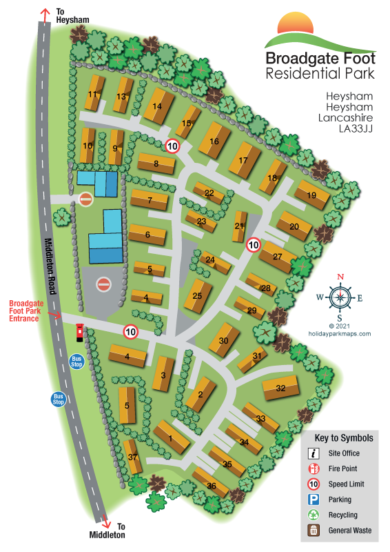
Mapped wayfinding includes two bus stops on Middleton Road, a fire point near the entrance, signs displaying a speed limit of 10 and two no-entry symbols near the western building area. The lower-right key also lists site office, parking, recycling and general waste, though their positions are not clearly marked. A compass rose, destination arrows and the large upper-right identity block complete the single portrait artwork. The enlarged detail views show portions of this same plan and key, not additional estate sections.
 Enlarge this map ↗
KEEP EXPLORING
Chosen for shared landscapes, accommodation or facilities.
 Explore the map ↗
United Kingdom
Coastal park map with static-caravan rows, touring pitches, a camping field and two leisure clusters.
 Explore the map ↗
United Kingdom
A wooded Allerton park plan with colour-coded neighbourhoods, touring pitches and a central facilities hub.
 Explore the map ↗
United Kingdom
Illustrated coastal holiday-home plan with dense alphanumeric plot labels, orange-roofed amenities, a numbered facility key and beach-side context.
Features may come from the sample artwork, its key or published park information. Approximate numbers describe the drawing and may cover only part of a park. They are intended to help you compare map examples. Current facilities and booking information should be checked with the park.
TAKE A CLOSER LOOK
View the illustrated map in detail or choose a file to download. These are sample maps; contact the park for current visitor information.


LET’S MAP YOUR PARK
For a map quotation, find your park and draw a rough boundary around it. The area you select helps us work out the design time and price.
Draw your park for a quote ↗Or talk to our map designers
01751 473136
 broadgatecaravanpark_large.png
 broadgatecaravanpark_large.png