
Meandering watercourse
An unnamed bright-blue stream-like watercourse follows the lower estate boundary, bending around homes and forming tight meanders at the eastern end.
ILLUSTRATED PARK MAP · P039
Brookfield Park, Ashover Road, Old Tupton · United Kingdom
 Enlarge the map ↗
A SENSE OF THE PLACE
Brookfield Residential Park is located at Old Tupton on the edge of the Peak District. The operator describes an established park home community suited to retired and semi-retired residents.
The estate is presented for permanent residential living. Its map shows the arrangement of homes and internal access routes, making it an example of residential park mapping rather than a holiday booking page.
LOOK CLOSER
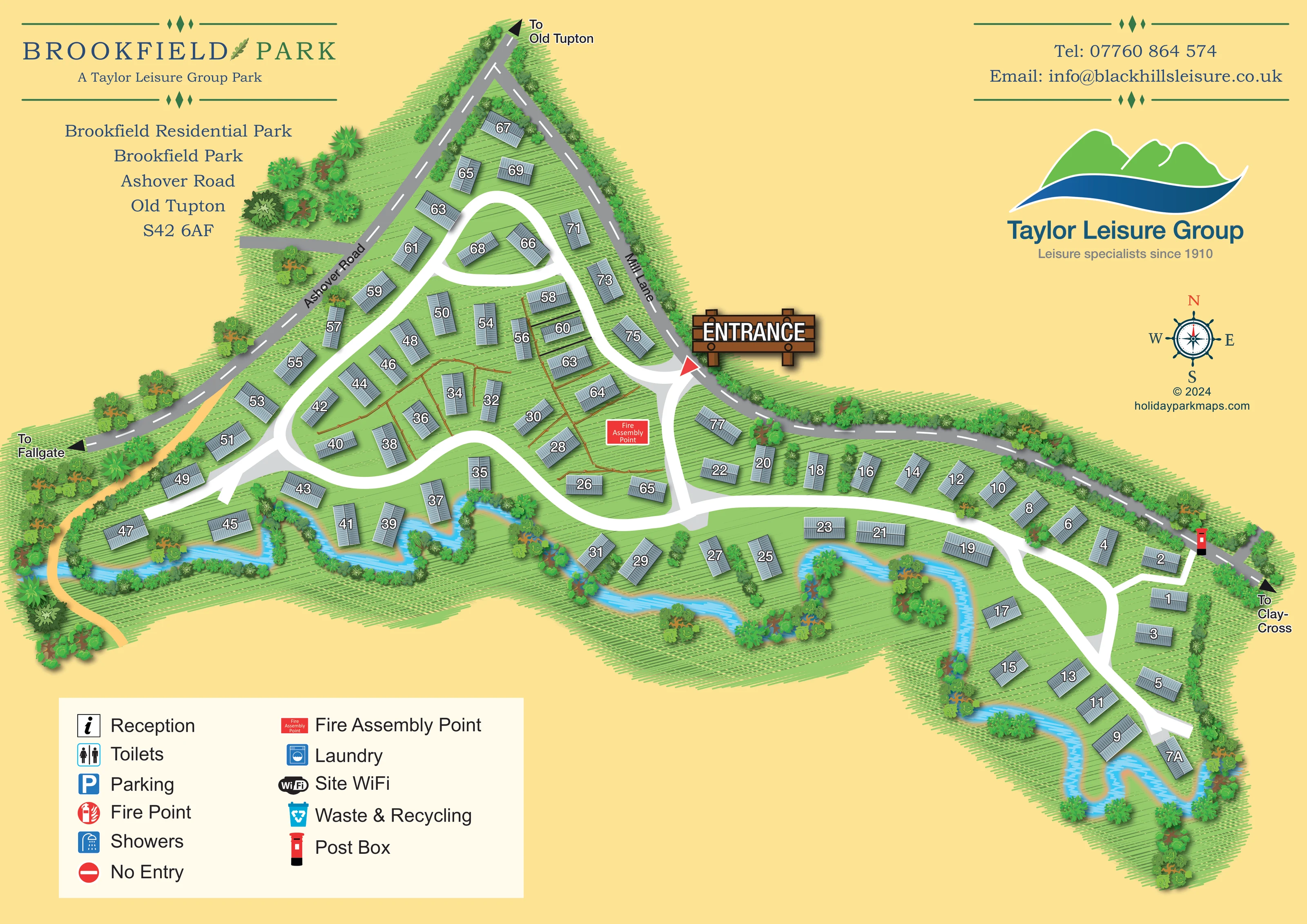
An unnamed bright-blue stream-like watercourse follows the lower estate boundary, bending around homes and forming tight meanders at the eastern end.
Layered trees and shrubs line the public roads, watercourse and estate edges, with smaller planted groups between homes.
Green spaces surround the homes; thin brown fence lines delineate several plots in the central part of the plan.
A large illustrated timber entrance sign and red pointer mark the connection from Mill Lane into the central internal road network.
Named grey public roads frame the upper edges of the estate, with directional arrows towards Old Tupton, Fallgate and Clay Cross.
Broad white roads form a small northern loop, a winding central circuit and a branching route through the long eastern arm.
A yellow path-like strip runs beside the western boundary and crosses the illustrated watercourse. Its destination and status are not stated.
A red labelled fire assembly point is positioned in the central area, just west of the entrance access road.
A large illustrated timber entrance sign and red pointer mark the connection from Mill Lane into the central internal road network.
Named grey public roads frame the upper edges of the estate, with directional arrows towards Old Tupton, Fallgate and Clay Cross.
Broad white roads form a small northern loop, a winding central circuit and a branching route through the long eastern arm.
A yellow path-like strip runs beside the western boundary and crosses the illustrated watercourse. Its destination and status are not stated.
An unnamed bright-blue stream-like watercourse follows the lower estate boundary, bending around homes and forming tight meanders at the eastern end.
Layered trees and shrubs line the public roads, watercourse and estate edges, with smaller planted groups between homes.
Green spaces surround the homes; thin brown fence lines delineate several plots in the central part of the plan.
A red labelled fire assembly point is positioned in the central area, just west of the entrance access road.
A red-and-black post box symbol appears beside Mill Lane near the eastern end of the estate.
Reception appears in the symbol key, but no corresponding location is clearly marked on the plan.
Separate toilet and shower symbols appear in the key; their positions are not established by the illustrated estate.
A parking symbol is included in the key, without a clearly located parking area on the plan.
The key includes a fire-point symbol, distinct from the mapped fire assembly point.
Laundry is listed in the key, with no clearly identifiable mapped location.
Site WiFi is named in the key; the artwork does not indicate coverage or a specific location.
A waste and recycling symbol appears in the key, but its position is not clearly shown.
A no-entry symbol is included in the key; no corresponding restriction is clearly positioned on the plan.
READING THE MAP
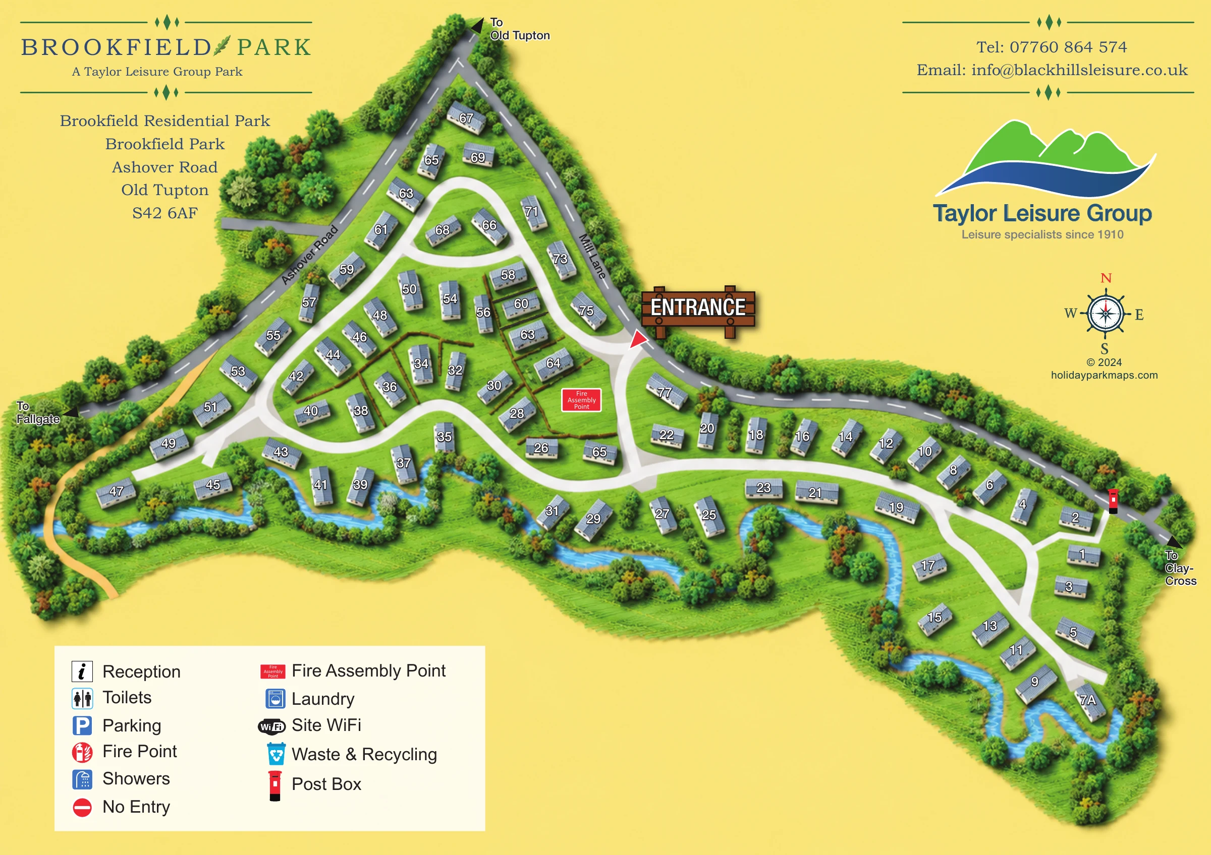
This illustrated map of Brookfield Residential Park presents an established park-home community in Old Tupton, on the edge of the Peak District. Rather than organising holiday pitches or booking zones, it focuses on the relationship between individual homes, internal estate roads and the surrounding road network. Approximately 70 home illustrations give the plan a medium-sized residential scale, with clear roof-top numbers helping readers locate a particular address.
The estate has a distinctive shape: a triangular northern section opens into a longer arm that curves towards the south-east. Ashover Road and Mill Lane frame its upper edges, while a bright-blue, meandering watercourse traces much of the lower boundary. Trees, shrubs and textured green ground give the artwork a landscaped character without obscuring the routes.
A large timber-style entrance sign provides an immediate arrival landmark. The pale-yellow page also accommodates Brookfield and Taylor Leisure Group branding, local direction arrows, a compass and a spacious symbol key. This sample is particularly relevant to residential estates needing an approachable overview of homes and access routes rather than a resort-style attractions map.
The plan uses an overhead view to make Brookfield's irregular layout easy to follow. Grey roads with dashed centre lines identify Ashover Road and Mill Lane around the upper perimeter, with arrows pointing towards Old Tupton, Fallgate and Clay Cross. The entrance is highlighted near the centre by a large illustrated wooden sign and a red triangular pointer. From that junction, broad white estate roads lead into a small northern loop, wind around the central homes and continue through the elongated eastern section.
Individual homes are drawn as grey-blue rectangular roofs with fine parallel lines, slight shadows and prominent outlined numbers. Their angles respond to the curving roads, creating loose rows and clusters rather than a uniform grid. Several central plots have brown fence divisions, while green spaces and scattered planting separate other units.
The most conspicuous landscape feature is the unnamed blue watercourse along the lower edge. It bends behind groups of homes and develops tight meanders near the south-eastern tip. Dense planting follows its banks and the roadside boundaries. A yellow, unlabelled path-like strip crosses the watercourse at the western end, adding another distinct route treatment without specifying its use.
A red fire assembly point label is placed near the central access road, and a pillar-box symbol appears beside Mill Lane towards the eastern end. The large lower-left key also lists reception, toilets, parking, fire point, showers, no entry, laundry, site WiFi and waste and recycling; these entries are not clearly located on the estate itself.
The single landscape-format artwork balances the plan with a title and address block at upper left, operator branding and contacts at upper right, and a decorative compass in the open right-hand space.
 Enlarge this map ↗
KEEP EXPLORING
Chosen for shared landscapes, accommodation or facilities.
 Explore the map ↗
United Kingdom
Illustrated coastal campsite plan with named fields, electric pitch colours, beach routes and the Afon Hen.
 Explore the map ↗
United Kingdom
A woodland touring-park map with colour-coded pitches, a stream and footprint-marked walks.
 Explore the map ↗
United Kingdom
Colour-coded campsite map with riverside pitches, bell tents, a swimming pool and fishing lake.
Features may come from the sample artwork, its key or published park information. Approximate numbers describe the drawing and may cover only part of a park. They are intended to help you compare map examples. Current facilities and booking information should be checked with the park.
LET’S MAP YOUR PARK
For a map quotation, find your park and draw a rough boundary around it. The area you select helps us work out the design time and price.
Draw your park for a quote ↗Or talk to our map designers
01751 473136