
First Field and Second Field
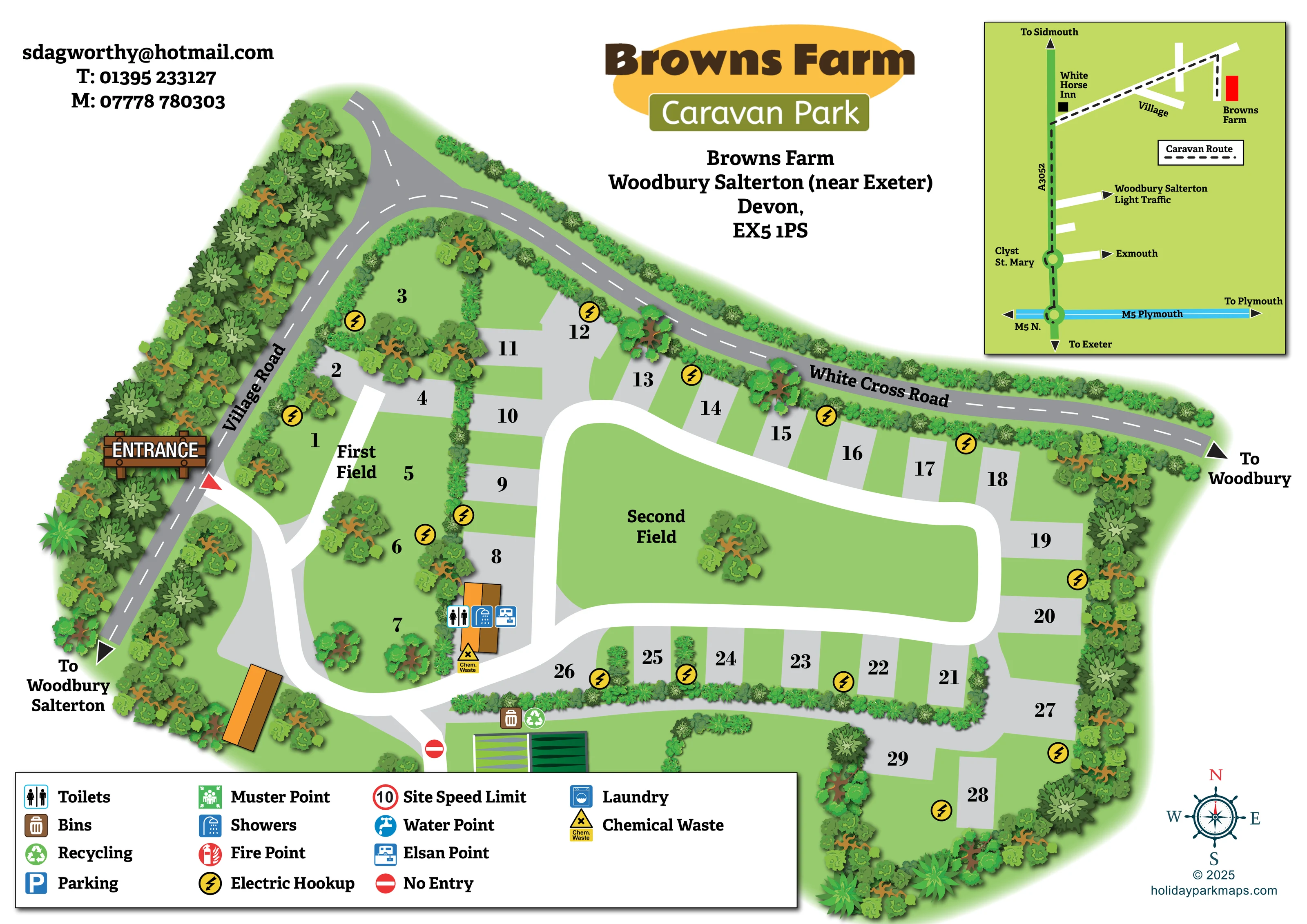
Two named areas organise the pitches: a smaller, more subdivided First Field and a larger Second Field with an open green centre.
ILLUSTRATED PARK MAP · P042
Browns Farm, Woodbury Salterton, near Exeter, Devon · United Kingdom
 Enlarge the map ↗
A SENSE OF THE PLACE
Browns Farm Caravan Park is based at Browns Farm, Woodbury Salterton, near Exeter, Devon. The location provides access to Exeter and Woodbury Common. Every pitch has electric hookup and a drinking-water tap; hardstandings are available. Some premier pitches have individual chemical-toilet emptying points.
Facilities include showers and toilets, an accessible toilet, laundry and Wi-Fi. The Exeter–Exmouth bus can stop on request at the park entrance.
LOOK CLOSER
Two named areas organise the pitches: a smaller, more subdivided First Field and a larger Second Field with an open green centre.
Dense illustrated trees frame the park, while hedges divide pitch groups and scattered trees punctuate the grass areas.
Toilet and shower symbols identify the orange-roofed service building between the two fields.
An Elsan symbol and a labelled chemical-waste marker appear beside the service building.
Repeated yellow lightning-bolt symbols mark hookup locations throughout the pitch areas.
Bin and recycling symbols identify a shared collection location near the lower internal junction and green-roofed structures.
A timber-style ENTRANCE sign and red triangular marker highlight the access from Village Road.
Broad white internal lanes serve the two fields, with a large loop around the Second Field lawn. A no-entry symbol marks a lower branch.
Toilet and shower symbols identify the orange-roofed service building between the two fields.
An Elsan symbol and a labelled chemical-waste marker appear beside the service building.
Repeated yellow lightning-bolt symbols mark hookup locations throughout the pitch areas.
Bin and recycling symbols identify a shared collection location near the lower internal junction and green-roofed structures.
Laundry is included in the key, but a corresponding location is not clearly marked on the main plan.
A water-point symbol is included in the key without a clearly identifiable placement on the main plan.
Parking appears in the key; no separate parking location is clearly identified on the plan.
The legend includes muster-point and fire-point symbols, without clearly visible corresponding locations.
The key contains a red-ringed speed-limit symbol displaying 10; no unit is specified.
A timber-style ENTRANCE sign and red triangular marker highlight the access from Village Road.
Broad white internal lanes serve the two fields, with a large loop around the Second Field lawn. A no-entry symbol marks a lower branch.
Two named areas organise the pitches: a smaller, more subdivided First Field and a larger Second Field with an open green centre.
Dense illustrated trees frame the park, while hedges divide pitch groups and scattered trees punctuate the grass areas.
Named public roads border the left and upper sides of the site, with directional arrows towards Woodbury Salterton and Woodbury.
A separate schematic shows a dashed caravan route from the M5 and A3052 to Browns Farm. It labels Clyst St. Mary, the White Horse Inn, a light-traffic approach to Woodbury Salterton and directions towards Exeter, Exmouth, Sidmouth and Plymouth.
Operator information identifies an accessible toilet, laundry and Wi-Fi. These details are not all located explicitly by the main plan.
Operator information states that pitches have electric hookup and drinking-water taps, with individual chemical-toilet emptying points on some premier pitches. The map does not distinguish a premier-pitch category.
Operator information says the Exeter–Exmouth bus can stop on request at the park entrance; this is not depicted as a bus-stop symbol.
READING THE MAP
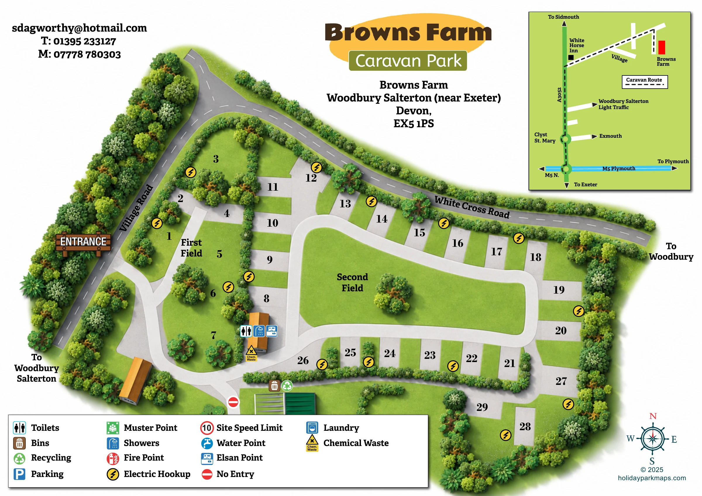
This illustrated map of Browns Farm Caravan Park combines a compact touring-site plan with a separate caravan approach guide. Set at Woodbury Salterton, near Exeter in Devon, the park is presented as two named fields enclosed by trees and hedges. Approximately 30 numbered pitches give the artwork a small-site scale, with grass spaces and grey hardstanding-style bays arranged around clear internal lanes.
The map’s most recognisable feature is the contrast between the smaller First Field and the larger Second Field, where a broad white loop surrounds an open green centre. A timber-style entrance sign marks arrival from Village Road, while coloured symbols highlight electric hookups, the toilet and shower building, chemical disposal, bins and recycling.
The upper-right inset adds a different kind of wayfinding: a simplified road diagram showing the caravan approach from the M5 and A3052. Together, the two views address both stages of a visitor’s journey—reaching the park and finding their way around its pitches and shared facilities.
The main plan follows an irregular, tree-lined site beneath White Cross Road, with Village Road running diagonally along its left boundary. Arrival is emphasised by a large illustrated timber sign and a red triangular entrance marker. From here, white internal lanes lead into the smaller First Field and connect with the larger Second Field to the right.
The First Field has a more intimate arrangement of grass spaces, scattered trees and hedge divisions, with grey-surfaced pitches along its eastern side. The Second Field is organised around a broad loop enclosing an open lawn with a single illustrated tree. Numbered bays line the outside of this loop, and a short lower extension reaches another small pitch group. Large black numbers remain conspicuous against both grass and grey surfaces.
An orange-roofed service building between the fields carries toilet, shower and Elsan symbols, with a chemical-waste marker beside it. Yellow lightning-bolt symbols identify hookup locations around the pitch areas. Bins and recycling are marked near the lower junction, where a no-entry sign also identifies a restricted branch. The wide bottom legend explains these symbols alongside additional entries for laundry, water, parking, fire points, a muster point and the site speed limit.
The upper-right approach inset uses a deliberately simpler graphic language: green land, coloured road lines, roundabout circles, arrows and a dashed caravan route. It connects Browns Farm with the A3052 and M5 and includes the White Horse Inn as a named landmark. A bold park title, address block, contact details and compass rose complete the single-page composition.
 Enlarge this map ↗
KEEP EXPLORING
Chosen for shared landscapes, accommodation or facilities.
 Explore the map ↗
United Kingdom
Illustrated Sanday aire map with a seasonal maze, café barn and motorhome service area.
 Explore the map ↗
United Kingdom
Ashby Park map with seven fishing lakes, colour-coded accommodation and illustrated wooded shorelines.
 Explore the map ↗
United Kingdom
A colour-coded touring park plan with named pitch areas, service symbols and Coast Path links.
Features may come from the sample artwork, its key or published park information. Approximate numbers describe the drawing and may cover only part of a park. They are intended to help you compare map examples. Current facilities and booking information should be checked with the park.
LET’S MAP YOUR PARK
For a map quotation, find your park and draw a rough boundary around it. The area you select helps us work out the design time and price.
Draw your park for a quote ↗Or talk to our map designers
01751 473136