
Orchard
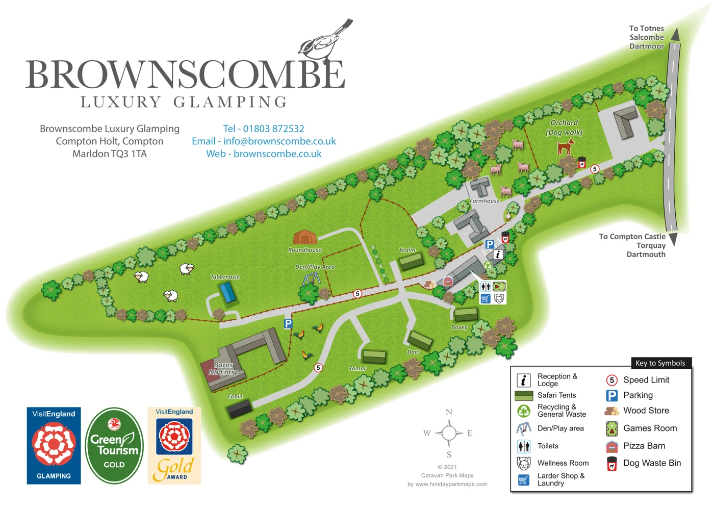
A named orchard compartment also serves as the mapped dog-walking area. Its boundary is suggested by trees and fencing; no orchard area or tree inventory is stated.
ILLUSTRATED PARK MAP · P419
Brownscombe Luxury Glamping, Compton Holt, Compton, Marldon · United Kingdom
 Enlarge the map ↗
A SENSE OF THE PLACE
Brownscombe provides glamping accommodation at Compton near Marldon in Devon. Its cabins and safari tents offer a rural setting for families and couples looking to spend time outdoors.
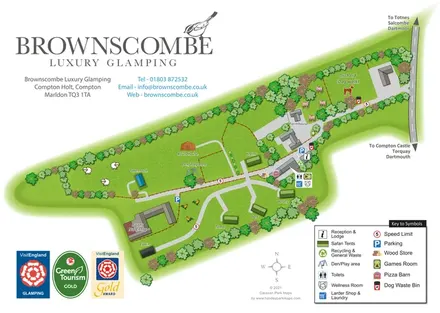
Accommodation layouts differ across the hillside site. Some options have parking close by and flatter access, so guests can choose a property that suits their needs. The map helps explain these differences and the relationship between accommodation and shared spaces.
LOOK CLOSER
A named orchard compartment also serves as the mapped dog-walking area. Its boundary is suggested by trees and fencing; no orchard area or tree inventory is stated.
Large grass-textured spaces around accommodation and farm buildings are subdivided by brown post-and-rail-style lines. These are depicted enclosures, not measured land parcels.
Repeated lobed tree-canopy symbols line much of the site edge and several internal divisions. Their decorative density is not evidence of a measured woodland extent or exact tree positions.
Sheep, pink farm animals, poultry and a waterfowl illustration give the map a farm character. These are pictorial setting cues, not a livestock inventory or proof of visitor animal activities.
An information symbol identifies the combined Reception & Lodge location. The artwork does not establish whether Lodge means a communal building, a dwelling or separately bookable accommodation.
Shared toilets are located by a callout pointing to the long amenities building. No shower or accessible-toilet designation accompanies the symbol.
A combined shop and laundry facility uses a shopping-trolley symbol. The map does not separate their internal locations or describe their services.
An indoor games facility is represented by a stylised games-table pictogram; the artwork does not specify its full equipment.
An information symbol identifies the combined Reception & Lodge location. The artwork does not establish whether Lodge means a communal building, a dwelling or separately bookable accommodation.
Shared toilets are located by a callout pointing to the long amenities building. No shower or accessible-toilet designation accompanies the symbol.
A combined shop and laundry facility uses a shopping-trolley symbol. The map does not separate their internal locations or describe their services.
An indoor games facility is represented by a stylised games-table pictogram; the artwork does not specify its full equipment.
A wellness room is shown using a face-and-hands pictogram. Treatments, staffing and availability are not stated.
A food-related facility called Pizza Barn is marked on the long building. No opening schedule or service arrangement is supplied.
A log-stack pictogram marks a wood store beside the amenities building.
A den/play area is labelled and illustrated with swings. The symbol does not establish the complete play-equipment inventory.
A combined recycling and general-waste point is shown near reception.
Dog-waste-bin symbols are placed by the orchard approach and near reception. They support the presence of mapped dog facilities, not a current park-wide pet policy.
The orchard is explicitly designated as a dog-walking area. No measured circuit, opening conditions or off-lead policy is given.
Parking is marked near reception and beside the western barns. White bay lines are drawn at reception, but no parking capacity is stated.
Red-ringed signs carrying the numeral 5 mark the approach and internal lanes. The key identifies these as speed-limit signs; no speed unit is printed.
A roof-plan building is labelled Farmhouse. Its residential, operational or guest-accommodation role is not specified.
The south-western barn complex is explicitly marked as a no-entry area. It is not counted as guest accommodation.
A named orchard compartment also serves as the mapped dog-walking area. Its boundary is suggested by trees and fencing; no orchard area or tree inventory is stated.
Large grass-textured spaces around accommodation and farm buildings are subdivided by brown post-and-rail-style lines. These are depicted enclosures, not measured land parcels.
Repeated lobed tree-canopy symbols line much of the site edge and several internal divisions. Their decorative density is not evidence of a measured woodland extent or exact tree positions.
Sheep, pink farm animals, poultry and a waterfowl illustration give the map a farm character. These are pictorial setting cues, not a livestock inventory or proof of visitor animal activities.
READING THE MAP
Brownscombe Luxury Glamping is a small-site example with plenty of individual character. The Devon artwork uses named safari tents and other distinctive buildings to create a welcoming illustrated plan, with branching lanes and short approach paths linking the accommodation to shared facilities.
Reception, a larder shop, laundry, games room, wellness room and Pizza Barn are among the features identified on the map. A den and play area, orchard dog walk, wood store, parking and waste points add the practical details guests need during a stay. Farm buildings, fenced green spaces and animal illustrations reinforce the setting without overwhelming the accommodation labels.
This sample is useful for glamping businesses, farm stays and small retreats where each accommodation unit has its own identity. It demonstrates how a map can communicate atmosphere as well as directions, using building shapes, names and landscape detail to make a compact site feel distinctive. The result is a design reference for parks that want their map to reflect the experience they offer.
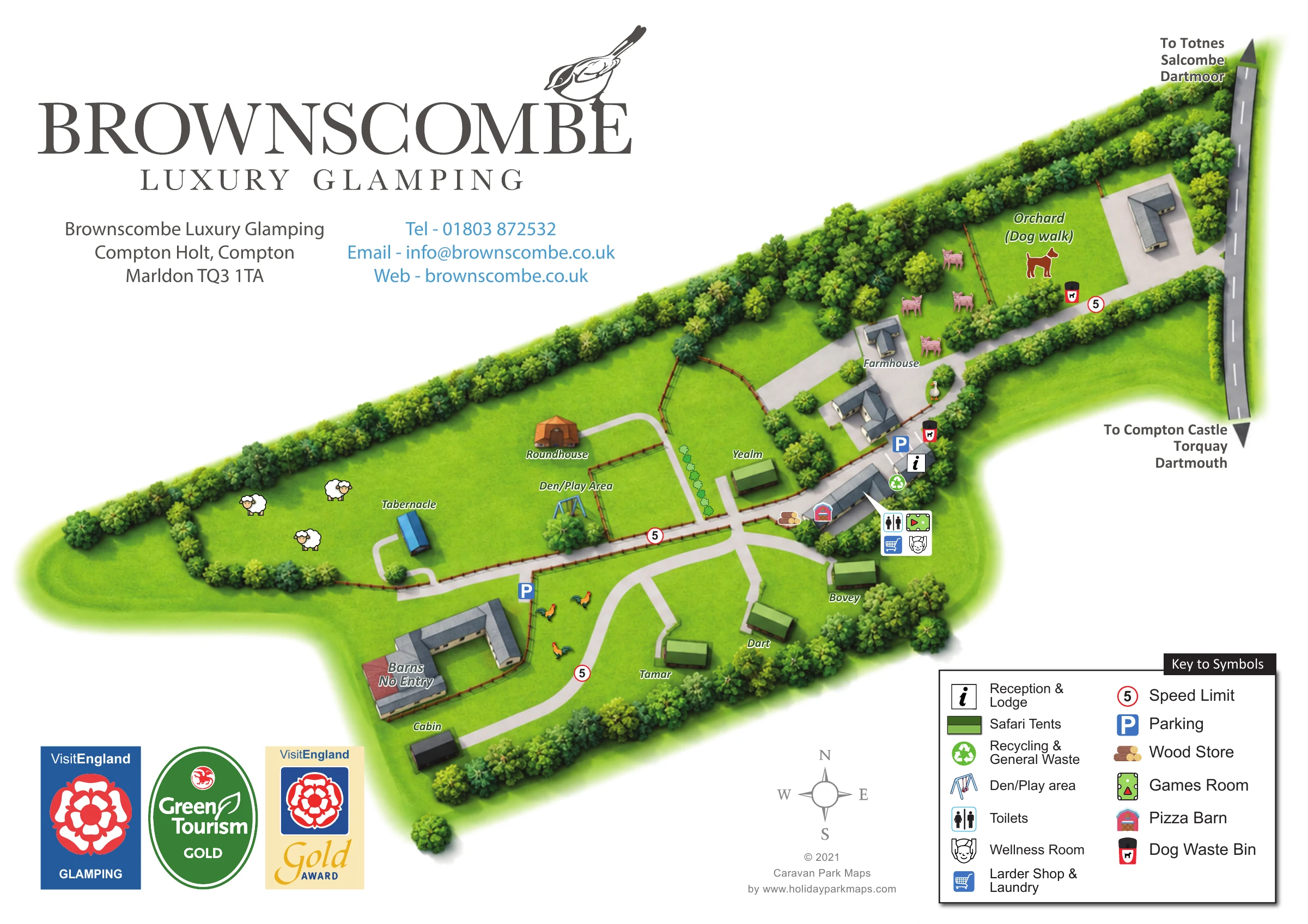
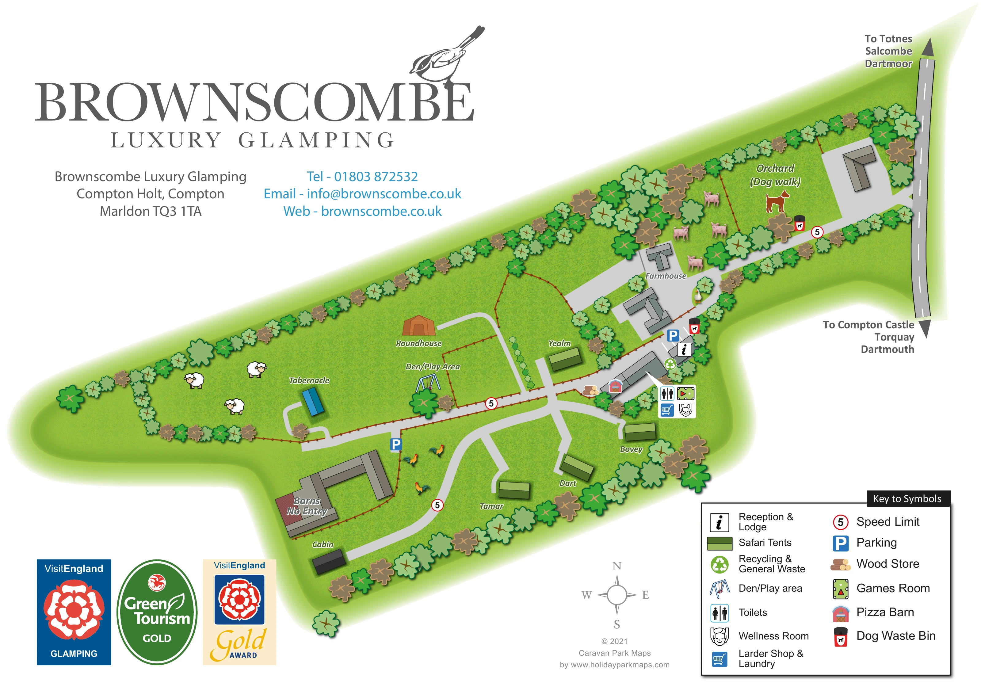
The Brownscombe Luxury Glamping artwork presents an elongated rural site diagonally across a white landscape page. A large grey serif wordmark with a perched bird dominates the upper-left space, with the park's address and blue contact details beneath it. The main illustration combines an overhead site plan with shaded roof shapes, tree-canopy symbols and more pictorial animals, swings and a brown Roundhouse depiction.
An external road runs down the right-hand side, carrying directional arrows towards Totnes, Salcombe and Dartmoor at one end and Compton Castle, Torquay and Dartmouth at the other. An approach branches into the site beside the labelled Orchard (Dog walk), then passes the farmhouse towards reception and the shared buildings. Grey internal lanes spread west and south, with narrower spurs reaching individually named structures. Brown fence lines and rows of stylised trees organise the grass-textured spaces without forming a regular pitch grid.
The green accommodation symbols are keyed as safari tents and carry the names Yealm, Bovey, Dart and Tamar. A dark Cabin symbol lies beyond the restricted barn group, while Tabernacle and Roundhouse occupy the western fields. Their distinct representations help orientation, although the key does not explain every accommodation category. The den/play area is marked with swings near the western lane.
Facilities are concentrated around the east-central buildings. Reception, parking, recycling, dog-waste bins, a wood store and Pizza Barn use recognisable pictograms. A white pointer callout groups toilets, games room, wellness room and larder shop/laundry against the shared amenities building. The lower-right key explains these symbols in two columns, while a compass and pale designer credit sit below the site. VisitEngland and Green Tourism badges occupy the lower-left margin.
Bright greens, muted grey roofs, brown fences and blue service symbols create a friendly, illustrative hierarchy. The visible © 2021 belongs to the designer credit; no survey date or scale is supplied. The artwork is best read as a guest-orientation and branded presentation map rather than a measured access plan.
 Enlarge this map ↗
KEEP EXPLORING
Chosen for shared landscapes, accommodation or facilities.
 Explore the map ↗
United Kingdom
Woodland-framed Barnsoul map with mixed accommodation, shared facilities and paw-marked walking routes.
 Explore the map ↗
United Kingdom
Illustrated farm campsite map with touring pitches, pods, camping fields and a riverside dog-walk route.
 Explore the map ↗
United Kingdom
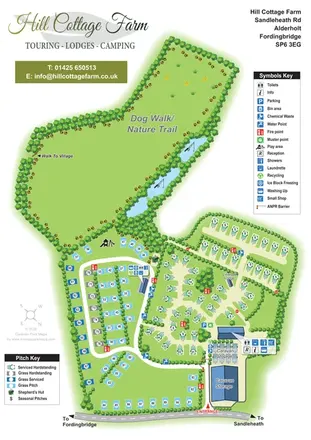
Portrait park map with mixed touring pitches, seasonal rows, ponds and an extensive dog walk.
Features may come from the sample artwork, its key or published park information. Approximate numbers describe the drawing and may cover only part of a park. They are intended to help you compare map examples. Current facilities and booking information should be checked with the park.
TAKE A CLOSER LOOK
View the illustrated map in detail or choose a file to download. These are sample maps; contact the park for current visitor information.


LET’S MAP YOUR PARK
For a map quotation, find your park and draw a rough boundary around it. The area you select helps us work out the design time and price.
Draw your park for a quote ↗Or talk to our map designers
01751 473136
 brownscombe_large.png