
Dog-themed grass enclosure
A hedge-bordered green space below the boat yard contains a dog silhouette and pawprints, suggesting a dog-related outdoor area without an explicit text label.
ILLUSTRATED PARK MAP · P421
Brynrodyn, Borth, Ceredigion · United Kingdom
 Enlarge the map ↗
A SENSE OF THE PLACE
Brynrodyn Caravan Park is based at Brynrodyn, Borth, Ceredigion. The park overlooks the sea and mountains. The park offers holiday-home ownership, seasonal touring and pitches for family tourers and tents.
The View at Brynrodyn is a restaurant and function venue with balcony and garden space.
LOOK CLOSER
A hedge-bordered green space below the boat yard contains a dog silhouette and pawprints, suggesting a dog-related outdoor area without an explicit text label.
The western edge shows blue sea, a yellow beach and a rocky shoreline, with a cove explicitly labelled near the lower-left side.
Hedges divide accommodation areas and frame routes; larger trees surround the southern edge, boat yard and main buildings.
The reception symbol is grouped with the facilities callout attached to The View, close to the entrance.
A restaurant symbol appears in the callout for the named building The View.
The View's callout includes the key's bar and beer garden symbol; a picnic-table illustration appears on adjacent grass.
A weightlifting pictogram locates the gym within the facilities associated with The View.
A games-table symbol is included in The View's facilities callout.
The reception symbol is grouped with the facilities callout attached to The View, close to the entrance.
A restaurant symbol appears in the callout for the named building The View.
The View's callout includes the key's bar and beer garden symbol; a picnic-table illustration appears on adjacent grass.
A weightlifting pictogram locates the gym within the facilities associated with The View.
A games-table symbol is included in The View's facilities callout.
The multicoloured soft play symbol appears in The View's callout.
Blue P symbols identify parking beside The View and around the north-eastern service buildings.
Toilet and shower symbols are grouped in the callout for the north-eastern amenities area.
A washing-machine symbol locates laundry facilities within the north-eastern amenities cluster.
A dishes symbol appears in the amenities callout near the touring accommodation.
The fridge/freezer pictogram is included in the north-eastern amenities callout.
A blue tap symbol is positioned beside the seasonal touring pitches.
Waste-point and general-waste symbols appear around the service area, including a general-waste marker beside seasonal touring.
Repeated red fire-point symbols are distributed through the holiday-home rows and touring areas.
A house pictogram on a north-eastern building corresponds to the named cottage entry in the key.
The labelled Boat Yard lies on the western side, illustrated with small boats beside the coastal route.
A hedge-bordered green space below the boat yard contains a dog silhouette and pawprints, suggesting a dog-related outdoor area without an explicit text label.
The western edge shows blue sea, a yellow beach and a rocky shoreline, with a cove explicitly labelled near the lower-left side.
Hedges divide accommodation areas and frame routes; larger trees surround the southern edge, boat yard and main buildings.
A red ENTRANCE label and arrow mark the connection from the eastern road into the park beside The View.
White branching and looping lanes weave between the numbered holiday-home rows and connect with the touring and service areas.
A white directional arrow on the northern grey route is labelled Walk To Borth, with a ten-minute estimate printed on the artwork.
The northern route leads west towards the shore and is labelled Walk To Cove, with a five-minute estimate. Footprint graphics continue towards the labelled cove.
The dark eastern road has directional labels to Borth and to Aberystwyth; the latter carries a fifteen-minute driving estimate.
The supplied park context describes The View as a restaurant and function venue with balcony and garden space; the balcony and function use are not separately illustrated.
READING THE MAP
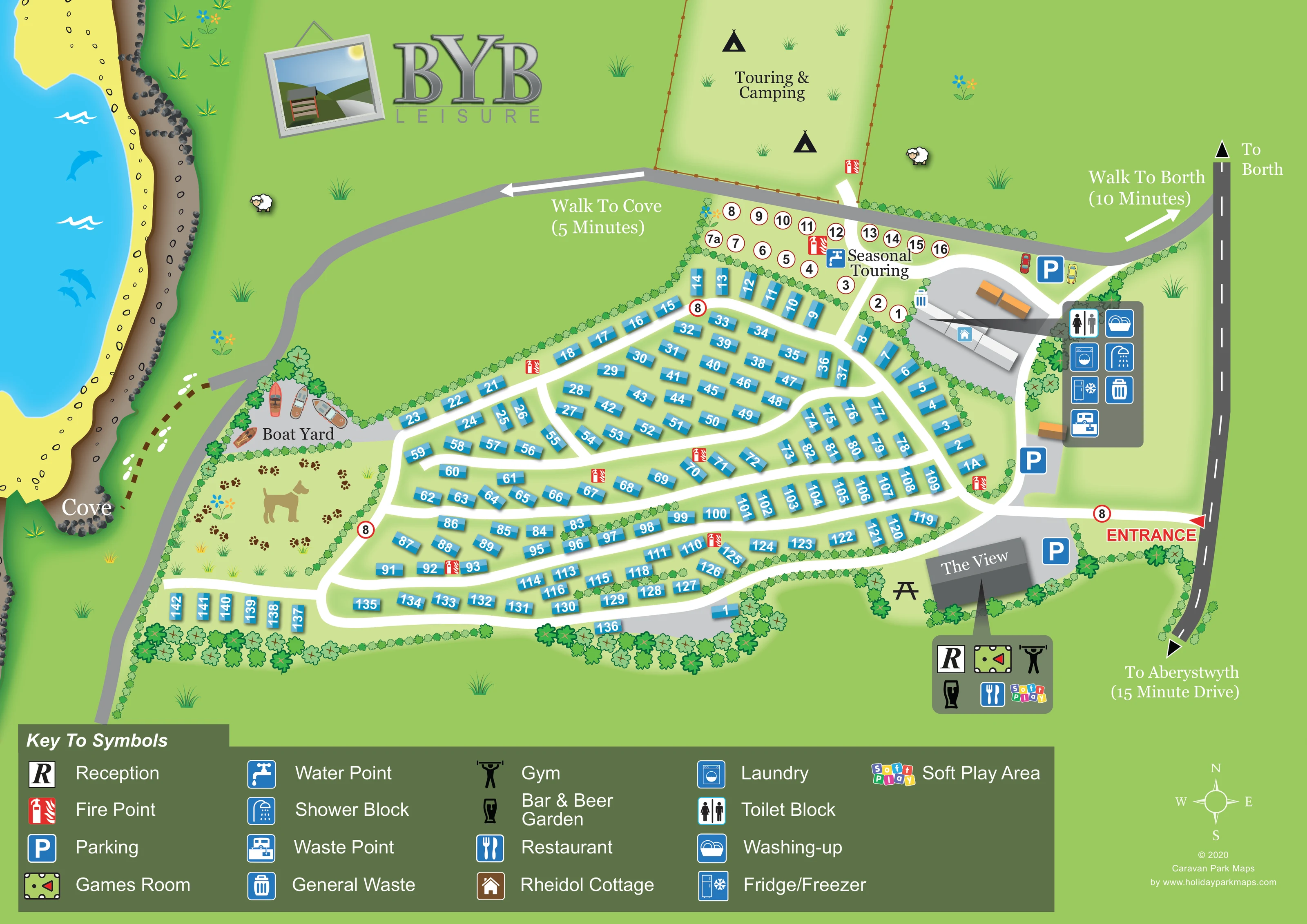
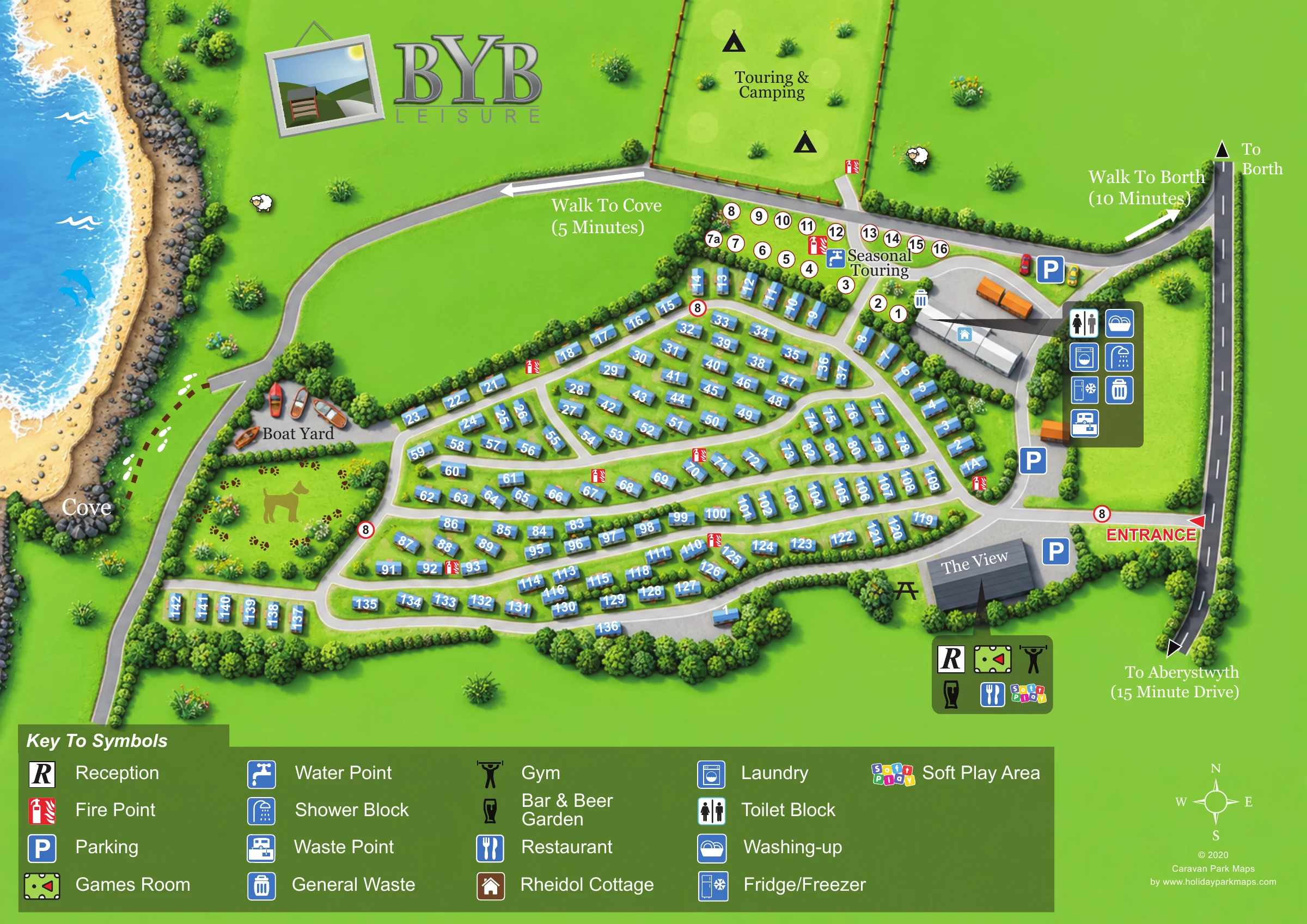
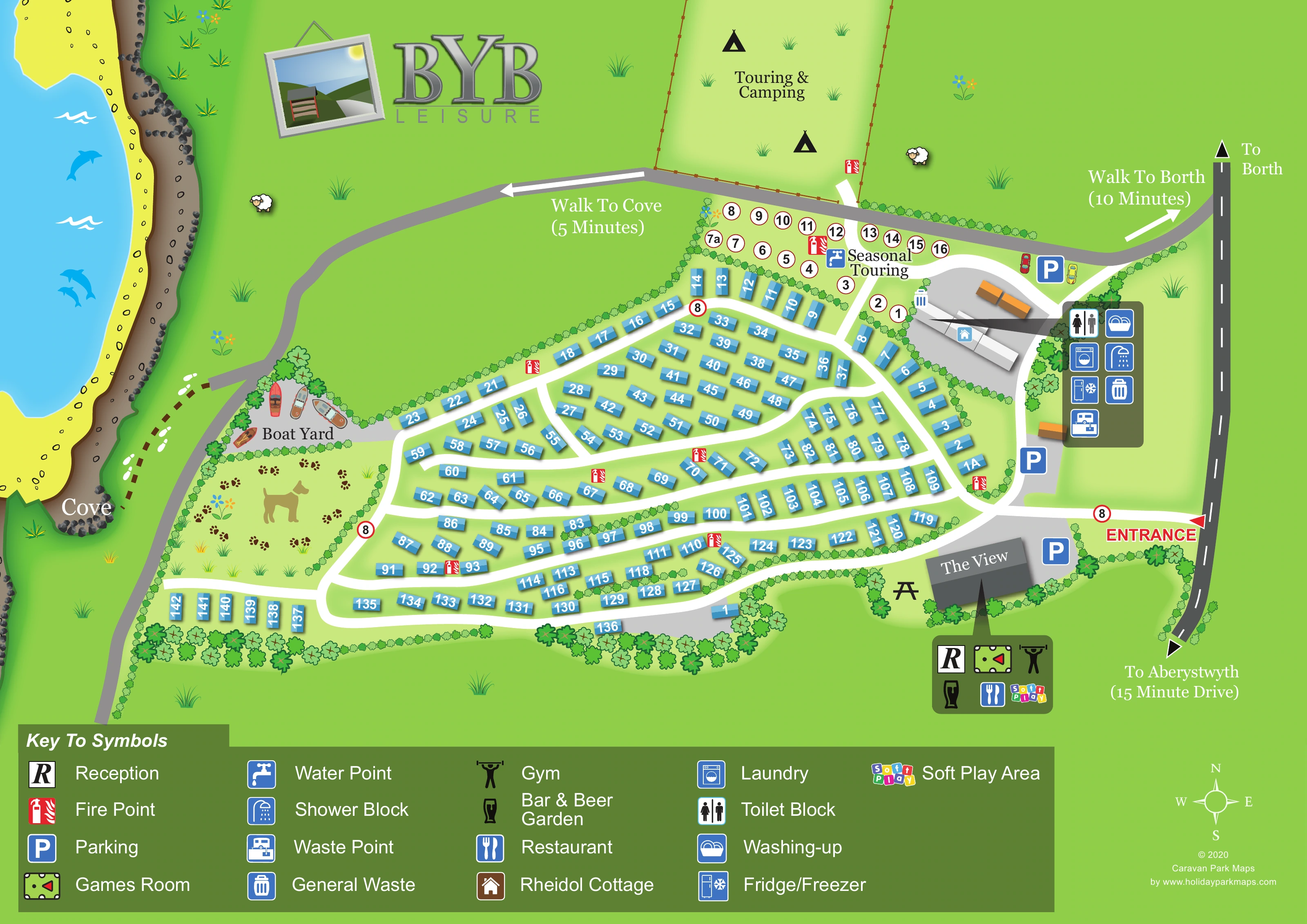
This illustrated map of Brynrodyn Caravan Park brings together a coastal setting, a substantial holiday-home area and separate touring and camping spaces in one landscape-format plan. The sea, beach and rocky cove run down the left-hand side, while the road towards Borth and Aberystwyth forms the right-hand boundary. Between them, blue numbered accommodation blocks follow gently curving white lanes, with hedges helping to distinguish the different parts of the park.
The View is a prominent arrival landmark beside the entrance, with a compact symbol panel identifying reception, dining and leisure facilities. A second amenities cluster sits closer to the seasonal touring pitches and the open touring and camping field. Walking arrows towards Borth and the cove extend the map's usefulness beyond finding an individual holiday home.
Large BYB Leisure branding, a broad symbol key and playful details such as boats, pawprints and coastal wildlife give the artwork a recognisable character. The result is a sample suited to parks that need to explain several accommodation types, shared facilities and connections to nearby scenery without turning the visitor map into a technical site drawing.
The plan is organised around a central fan of numbered blue holiday-home blocks. White lanes curve through these rows, connecting the southern accommodation with smaller groups near the northern boundary. Hedge lines and clusters of trees break up the layout and make the edges of each area easier to follow. Above the main accommodation, a pale enclosure contains the numbered seasonal touring pitches; the larger field beyond is labelled Touring & Camping and uses tent pictograms rather than individual pitch outlines.
Arrival is shown on the eastern side, where a red entrance arrow connects the outside road to the park. The View stands immediately inside this approach, with nearby parking and a callout for reception, restaurant, bar and beer garden, gym, games room and soft play. Further north, another callout groups toilets, showers, laundry, washing-up, fridge/freezer and waste facilities around the service buildings. A house symbol identifies Rheidol Cottage, while a water point is marked beside seasonal touring. Red fire-point symbols recur throughout the accommodation areas.
On the western side, the boat yard is illustrated with small boats. Below it, a hedge-bordered grass enclosure contains a dog and pawprint motif. The coastal route links the upper edge of the park with the labelled cove, and separate arrows indicate walking towards Borth. The eastern road also carries directions towards Borth and Aberystwyth.
The sea, sand, rocks and decorative wildlife establish the coastal setting, while a large footer key explains the pictograms. The supplied detail views enlarge this same legend; they are not separate maps or additional accommodation sections.
 Enlarge this map ↗
KEEP EXPLORING
Chosen for shared landscapes, accommodation or facilities.
 Explore the map ↗
United Kingdom
Coastal park map with static-caravan rows, touring pitches, a camping field and two leisure clusters.
 Explore the map ↗
United Kingdom
Coastal park plan with colour-coded pitches, named neighbourhoods and a Morecambe Bay walking route.
 Explore the map ↗
United Kingdom
A colour-zoned coastal park map with touring areas, woodland trails, ponds and a leisure club.
Features may come from the sample artwork, its key or published park information. Approximate numbers describe the drawing and may cover only part of a park. They are intended to help you compare map examples. Current facilities and booking information should be checked with the park.
TAKE A CLOSER LOOK
View the illustrated map in detail or choose a file to download. These are sample maps; contact the park for current visitor information.


LET’S MAP YOUR PARK
For a map quotation, find your park and draw a rough boundary around it. The area you select helps us work out the design time and price.
Draw your park for a quote ↗Or talk to our map designers
01751 473136
 brynrodynmap_large.png