
Touring and camping field
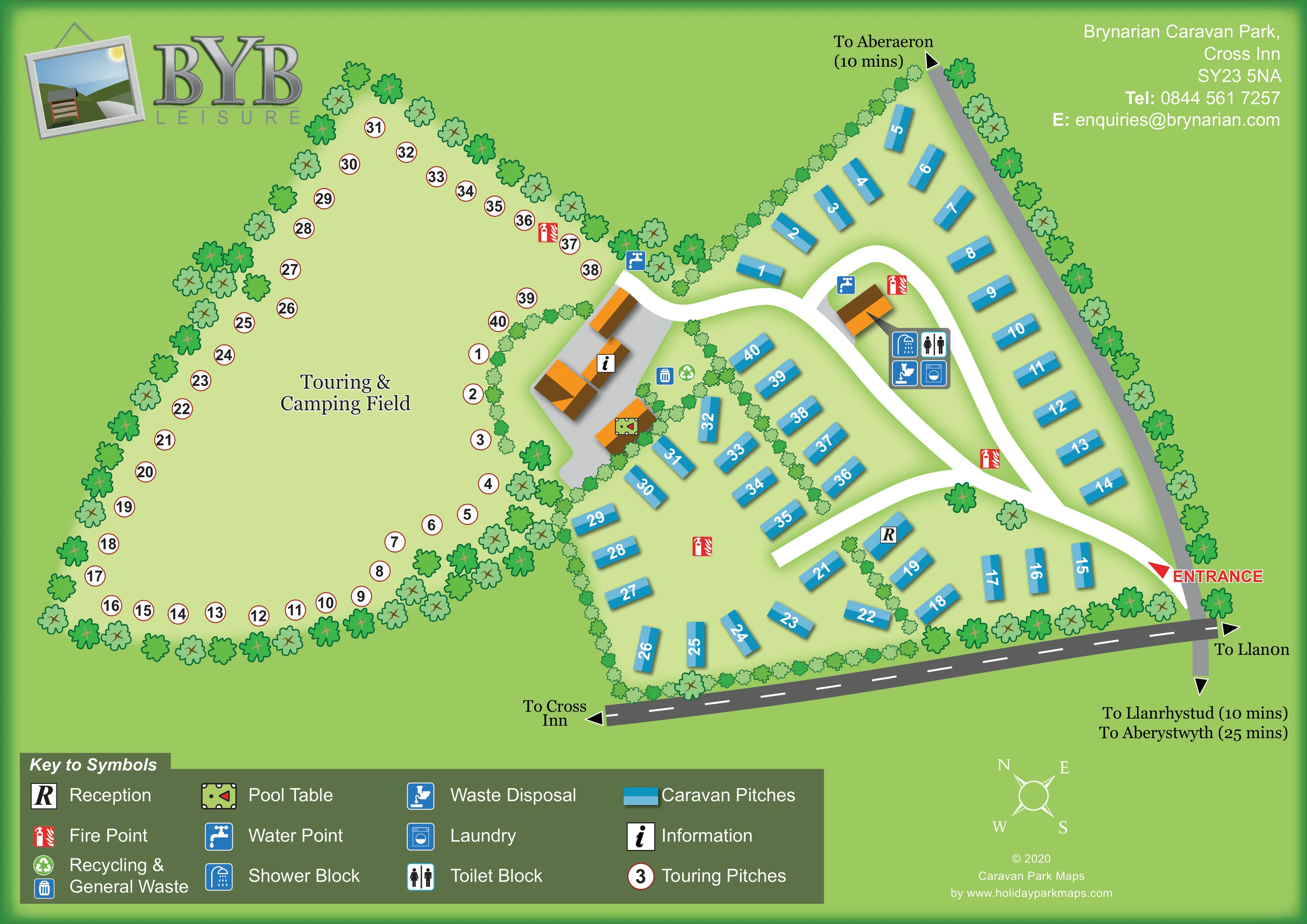
A large pale-green open field occupies the left side of the plan, with numbered touring positions arranged around its tree-lined perimeter.
ILLUSTRATED PARK MAP · P420
Brynarian Caravan Park, Cross Inn · United Kingdom
 Enlarge the map ↗
A SENSE OF THE PLACE
Brynarian Caravan Park is set among woodland and farmland at Cross Inn in Ceredigion. It combines holiday home ownership and seasonal touring with shorter camping, caravan and motorhome stays.
Grass pitches are available with or without electricity. Showers, water and waste points, laundry and a pool room provide practical facilities, while the countryside setting offers access to excursions around Cardigan Bay. Wi-Fi is available, although coverage can vary across this rural site.
LOOK CLOSER
A large pale-green open field occupies the left side of the plan, with numbered touring positions arranged around its tree-lined perimeter.
Stylised trees enclose the field and caravan perimeter, while smaller hedge-like runs divide accommodation groups and service areas.
An R symbol marks a blue unit beside the lower internal road, within the caravan area.
An information symbol is attached to the orange-roofed building group between the touring field and caravan area.
A recognisable pool-table illustration marks a separate small building in the central service courtyard.
Toilet and shower symbols are grouped beside an orange-roofed building inside the upper road loop.
A washing-machine symbol appears in the grouped service icons beside the upper amenity building.
A waste-disposal symbol is positioned with the toilet, shower and laundry facilities.
An R symbol marks a blue unit beside the lower internal road, within the caravan area.
An information symbol is attached to the orange-roofed building group between the touring field and caravan area.
A recognisable pool-table illustration marks a separate small building in the central service courtyard.
Toilet and shower symbols are grouped beside an orange-roofed building inside the upper road loop.
A washing-machine symbol appears in the grouped service icons beside the upper amenity building.
A waste-disposal symbol is positioned with the toilet, shower and laundry facilities.
Blue tap symbols identify water points at the touring-field service edge and beside the upper amenity building.
Recycling and bin symbols appear together beside the central service courtyard.
Repeated red fire-point symbols are distributed around the touring field edge and caravan roads.
A large pale-green open field occupies the left side of the plan, with numbered touring positions arranged around its tree-lined perimeter.
Stylised trees enclose the field and caravan perimeter, while smaller hedge-like runs divide accommodation groups and service areas.
A red entrance marker on the right leads into broad white roads that loop through the caravan area and branch towards the central service courtyard.
External roads carry arrows towards Cross Inn, Llanon, Aberaeron, Llanrhystud and Aberystwyth. Some directions include indicative journey times printed on the artwork.
READING THE MAP
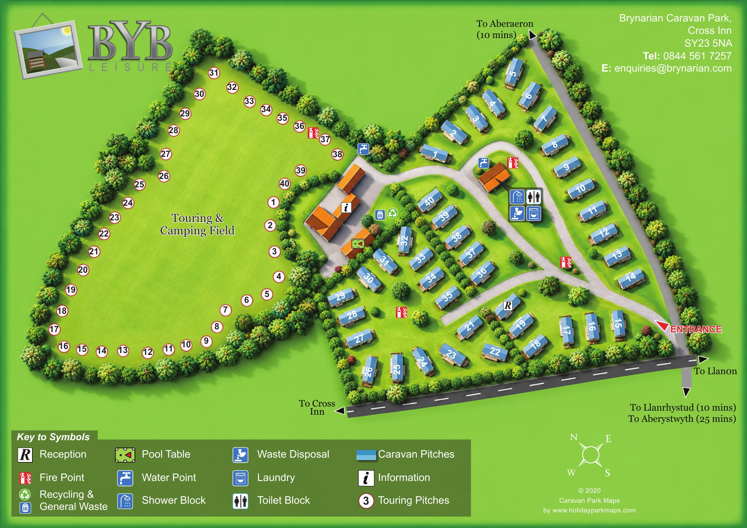
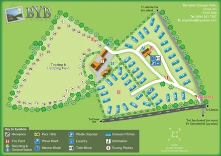
This map of Brynarian Caravan Park at Cross Inn in Ceredigion brings two different holiday settings into one clear plan: a spacious touring and camping field and a more closely arranged caravan area. Tree belts and hedged divisions give the artwork its rural character, while contrasting accommodation markers make the two areas immediately recognisable.
The touring field occupies the left of the page, with numbered circular markers around an open green centre. On the right, blue caravan shapes follow the park boundary and sit in smaller groups around curving white roads. Between them, orange-roofed buildings and facility symbols identify the practical service areas, including information, a pool table, water, waste and washing facilities.
A prominently marked entrance connects the internal layout to surrounding roads, with arrows towards Cross Inn and nearby Ceredigion destinations. The broad symbol key along the bottom supports the numbered plan without crowding the accommodation areas. This sample is particularly relevant to rural parks that need to show touring space, established caravan plots and shared facilities together, using a simple illustrated style rather than a technical site drawing.
The plan is organised around a clear left–right division. A large, pale-green touring and camping field fills the left side, enclosed by stylised trees and edged with numbered white circles. Its centre remains largely empty apart from the field name, communicating open space without suggesting a fixed arrangement of tent pitches. The caravan area on the right uses blue rectangular units, with one long outer row and several smaller groups separated by hedge-like planting.
Arrival is shown at the right-hand boundary with a red arrow and bold ENTRANCE label. From here, broad white roads curve through the caravan area, forming an upper loop and a lower branch. Another connection reaches the grey service courtyard beside the touring field. Reception is marked on a blue unit near the lower road, while an information symbol and a small pool-table illustration identify buildings in the central cluster.
Inside the upper loop, an orange-roofed amenity building is accompanied by shower, toilet, laundry and waste-disposal symbols. Water points appear at this building and at the touring-field service edge. Recycling and general-waste symbols sit beside the central courtyard, and red fire-point icons recur across both accommodation areas.
Grey external roads frame the lower and right edges, with destination arrows providing local context. A large olive-green legend explains both pitch-marker systems and the facility pictograms. BYB Leisure branding, the park contact block, a compass and designer credit complete the page. The legend enlargements show details of this same single-page artwork rather than additional park sections.
 Enlarge this map ↗
KEEP EXPLORING
Chosen for shared landscapes, accommodation or facilities.
 Explore the map ↗
United Kingdom
Tree-framed mixed-accommodation park map with two entrances, touring loops and a clearly illustrated social hub.
 Explore the map ↗
United Kingdom
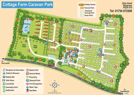
Illustrated touring and camping park map with numbered pitches, a fishing pond and a central farm courtyard.
 Explore the map ↗
United Kingdom
Woodland holiday-park map with named accommodation areas, touring loops and illustrated recreation facilities.
Features may come from the sample artwork, its key or published park information. Approximate numbers describe the drawing and may cover only part of a park. They are intended to help you compare map examples. Current facilities and booking information should be checked with the park.
TAKE A CLOSER LOOK
View the illustrated map in detail or choose a file to download. These are sample maps; contact the park for current visitor information.


LET’S MAP YOUR PARK
For a map quotation, find your park and draw a rough boundary around it. The area you select helps us work out the design time and price.
Draw your park for a quote ↗Or talk to our map designers
01751 473136
 brynarian_large.png