
Fishing and boating lake
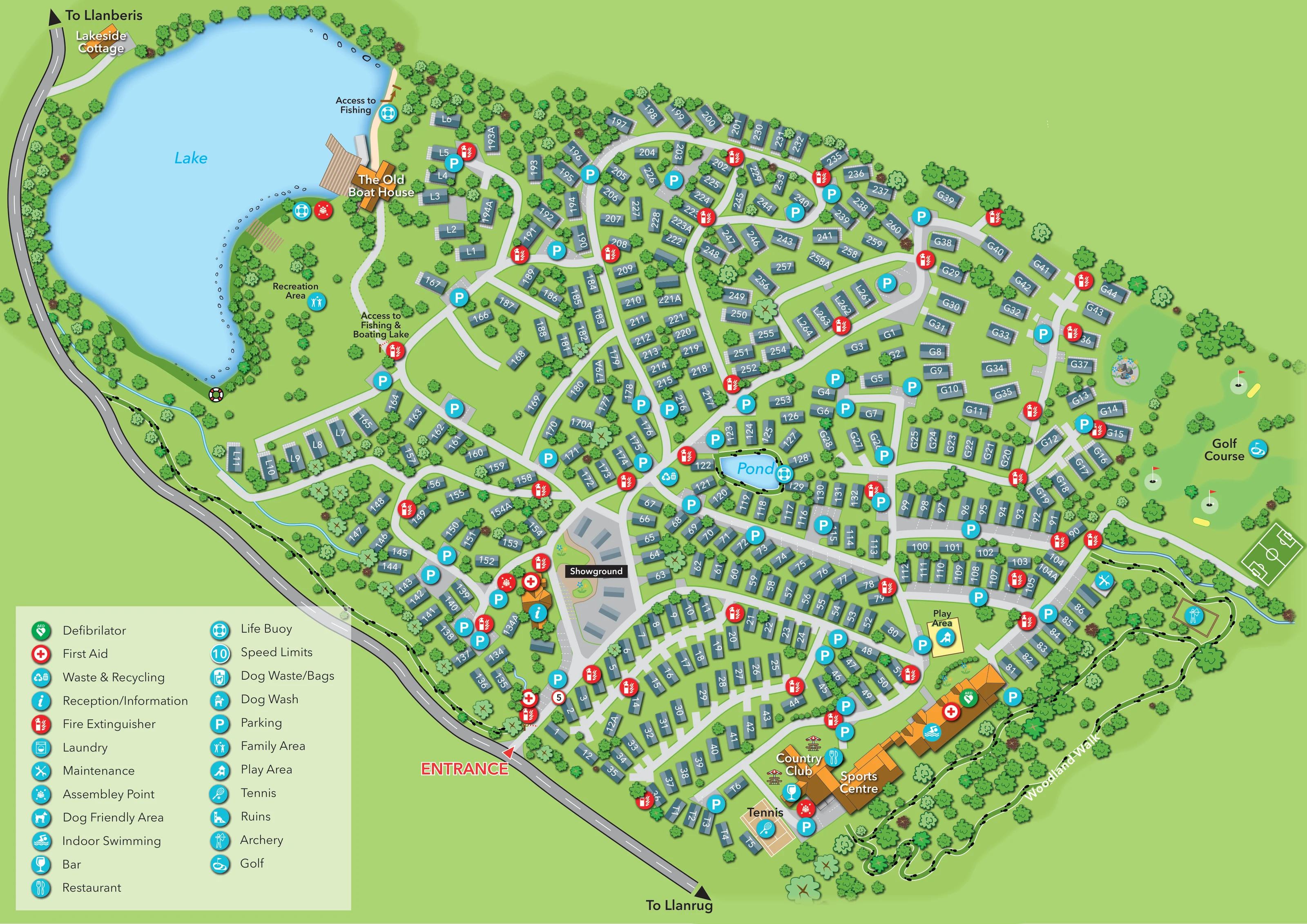
A large lake dominates the upper-left portion of the plan. Separate labels identify access to fishing and access to the fishing and boating lake.
ILLUSTRATED PARK MAP · P422
Llanrug, near Caernarfon, Gwynedd · United Kingdom
 Enlarge the map ↗
A SENSE OF THE PLACE
Brynteg Country and Leisure Retreat is set near Llanrug, between the mountains of Eryri and the North Wales coast. Its countryside location offers a base for family holidays and exploring the region.
Published visitor information describes a swimming pool, spa, gym and lakeside restaurant. The map shows how accommodation and leisure areas are arranged within the retreat, helping visitors plan their time on site.
LOOK CLOSER
A large lake dominates the upper-left portion of the plan. Separate labels identify access to fishing and access to the fishing and boating lake.
A smaller labelled pond sits among the central accommodation. A narrow blue watercourse also appears along parts of the western and eastern edges.
Dense tree symbols frame the lake and outer boundaries, with further planting between accommodation plots and around the leisure buildings.
Named lakeside building with an orange roof and a broad timber-coloured waterside deck.
An open, tree-dotted recreation area occupies the inward curve of the lake and carries a family-area symbol.
A labelled, looping walking route follows the wooded lower-right edge. White route lines and black footprint marks distinguish it from vehicle roads; related walking marks appear beside the pond and western boundary.
A red entrance arrow marks the lower-left arrival point from the boundary road. Large directional arrows indicate Llanberis at one end and Llanrug at the other.
Pale grey roads branch into loops and short spurs, with numerous cyan parking symbols and grey parking areas distributed through the accommodation.
A large lake dominates the upper-left portion of the plan. Separate labels identify access to fishing and access to the fishing and boating lake.
Named lakeside building with an orange roof and a broad timber-coloured waterside deck.
An open, tree-dotted recreation area occupies the inward curve of the lake and carries a family-area symbol.
A smaller labelled pond sits among the central accommodation. A narrow blue watercourse also appears along parts of the western and eastern edges.
Dense tree symbols frame the lake and outer boundaries, with further planting between accommodation plots and around the leisure buildings.
A labelled, looping walking route follows the wooded lower-right edge. White route lines and black footprint marks distinguish it from vehicle roads; related walking marks appear beside the pond and western boundary.
A red entrance arrow marks the lower-left arrival point from the boundary road. Large directional arrows indicate Llanberis at one end and Llanrug at the other.
Pale grey roads branch into loops and short spurs, with numerous cyan parking symbols and grey parking areas distributed through the accommodation.
An information symbol identifies an orange-roofed building beside the showground, a short way inside the entrance.
A labelled grey display area near reception contains arranged rectangular structures and landscaped islands.
Named orange-roofed leisure building near the lower edge, with illustrated outdoor picnic tables.
Named building adjoining the Country Club in the main southern leisure cluster.
The indoor-swimming symbol is placed on the long leisure building beside the Country Club and Sports Centre.
Bar and restaurant symbols are positioned at the Country Club area.
A tan court with white markings and a tennis symbol sits immediately below the Country Club.
A labelled yellow play-area rectangle lies among the accommodation just above the main leisure buildings.
An open green area on the right is labelled Golf Course and illustrated with flagged holes and yellow bunker shapes.
A green rectangular pitch with white football markings appears beside the golf area at the right-hand edge.
An archery symbol marks a small outlined activity area beside the Woodland Walk.
A crossed-tools symbol identifies a small service area near the eastern watercourse and archery area.
A waste-and-recycling point is marked near the central pond and road junction.
First-aid symbols appear around arrival, reception and the leisure buildings; a defibrillator is marked at the swimming building. Red fire-extinguisher symbols are distributed throughout the plan, with assembly points at reception, the leisure cluster and the lakeside.
Life-buoy symbols are positioned at the fishing access, near The Old Boat House and beside the central pond.
A circular speed marker is drawn near the entrance road, and the legend explains the speed-limit symbol.
Included in the legend, but a corresponding location is not clearly identifiable in the plan.
All three appear in the legend. Their positions are not clearly identifiable in the artwork, and the symbols do not establish a park-wide pet policy.
A ruins symbol is included in the legend without a clearly identifiable placement on the plan.
Published visitor information describes a spa and gym. Neither is individually labelled on this artwork.
READING THE MAP
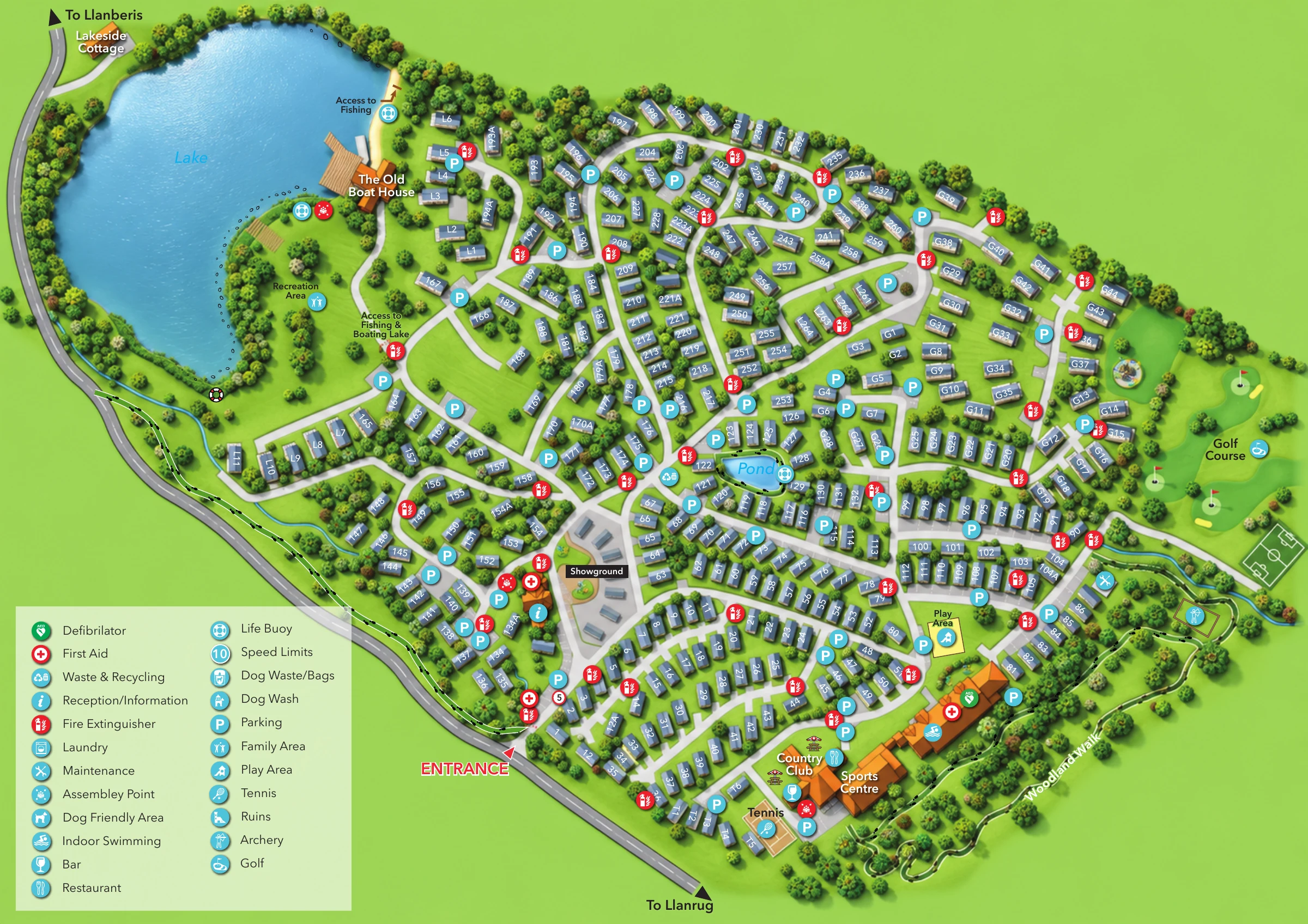
This illustrated map of Brynteg Country & Leisure Retreat brings together a densely arranged holiday park, a prominent fishing and boating lake, and a varied collection of leisure spaces. Set at Llanrug, near Caernarfon in Gwynedd, the retreat sits between the mountains of Eryri and the North Wales coast. The artwork makes its wooded, waterside character central to the visitor’s first impression.
The lake anchors the upper-left corner, with The Old Boat House, fishing access and an open recreation area along its shore. Across the rest of the plan, numbered holiday units follow curving roads and smaller branches, with parking symbols placed throughout. Orange-roofed buildings distinguish reception and the main leisure destinations from the slate-coloured accommodation.
At the lower edge, the Country Club and Sports Centre sit beside indoor swimming, tennis and a play area. Golf, a marked football pitch and archery extend the activity offering towards the right-hand boundary, where a footprint-marked Woodland Walk gives the landscape its own navigational layer.
The plan uses an overhead view with lightly dimensional buildings to explain a large, irregular site. A dark-grey boundary road runs down the left side and across the lower edge, with arrows towards Llanberis and Llanrug. The entrance is picked out in red. Just inside, an information symbol identifies reception beside a grey showground containing arranged display structures and small planted islands.
Pale-grey internal roads spread into loops, rows and short access spurs. Individual accommodation roofs carry white identifiers aligned to each unit, while cyan parking markers highlight parking areas throughout the park. A small terrace-fronted group sits beside the lake; the main accommodation continues around the central pond and into the eastern section. Trees occupy boundaries and gaps between plots, giving the dense layout a consistent wooded character.
The lake is drawn in pale blue with a shaded edge, shoreline stones and a broad deck at The Old Boat House. Labels distinguish fishing access from the route to the fishing and boating lake. The adjacent recreation area is marked for family use. A smaller pond, a narrow watercourse and footprint-marked paths add further landscape references.
The southern leisure cluster combines the Country Club, Sports Centre and indoor-swimming building, with bar and restaurant symbols, outdoor tables and a nearby tennis court. A play area lies just above it. On the right, golf holes, a football pitch and an archery enclosure sit beside the looping Woodland Walk.
A two-column key in the lower-left corner explains visitor, activity and emergency symbols. First aid, fire extinguishers, assembly points and life buoys are integrated into the plan rather than presented as a separate diagram.
 Enlarge this map ↗
KEEP EXPLORING
Chosen for shared landscapes, accommodation or facilities.
 Explore the map ↗
United Kingdom
A woodland estate park map combining caravan loops, touring pitches, riverside paths and Bruce’s Cave landmarks.
 Explore the map ↗
United Kingdom
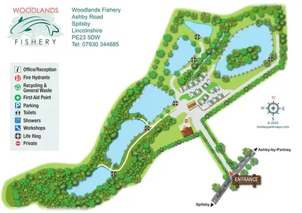
Illustrated fishery map with lakeside routes, wooded waters and a compact touring area.
 Explore the map ↗
United Kingdom
Woodland park map with mixed pitches, bell tents, lodges and a fishing lake.
Features may come from the sample artwork, its key or published park information. Approximate numbers describe the drawing and may cover only part of a park. They are intended to help you compare map examples. Current facilities and booking information should be checked with the park.
LET’S MAP YOUR PARK
For a map quotation, find your park and draw a rough boundary around it. The area you select helps us work out the design time and price.
Draw your park for a quote ↗Or talk to our map designers
01751 473136