
Lake and watersports edge
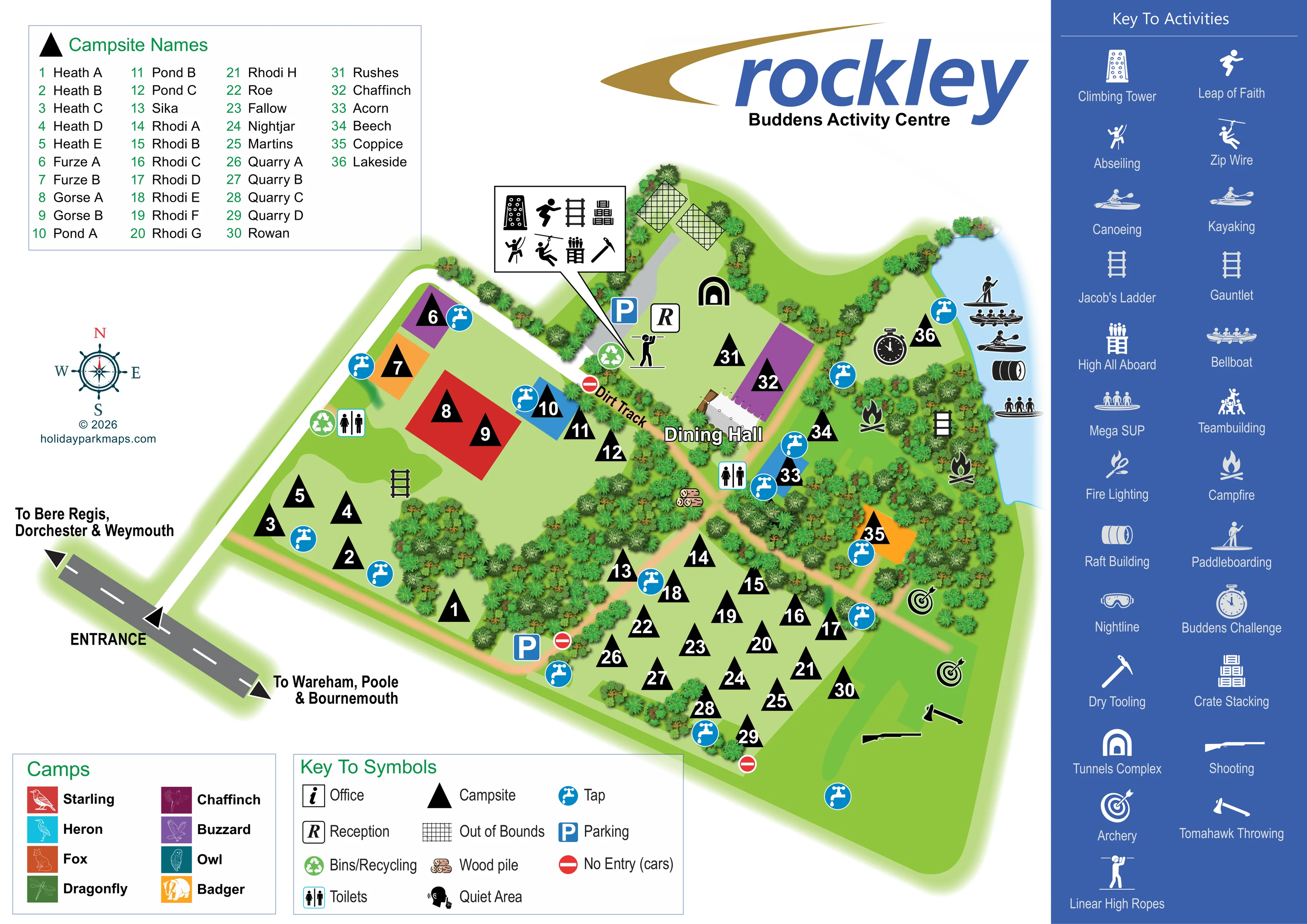
A pale-blue lake occupies the right edge, with a wooded shoreline, the Lakeside camping area and a vertical arrangement of watersports symbols.
ILLUSTRATED PARK MAP · P046
Puddletown Road, Wareham, Dorset · United Kingdom
 Enlarge the map ↗
A SENSE OF THE PLACE
Buddens is a camping and activity centre near Wareham in Dorset's Purbeck area. Developed by Dorset Scouts, its grounds include heath, woodland, water meadows and planted areas.
The centre has hosted large Scouting events and provides a setting for organised outdoor experiences. Its map brings together camping spaces and activity areas across a varied landscape, helping groups understand the site before their visit.
LOOK CLOSER
A pale-blue lake occupies the right edge, with a wooded shoreline, the Lakeside camping area and a vertical arrangement of watersports symbols.
Dense illustrated trees divide the site into camping clearings, frame the lake and separate activity spaces.
An R marker identifies reception beside the upper parking area and the northern activity cluster.
A labelled, illustrated building sits centrally beside the dirt track, between the main camping clearings and the lakeside woodland.
Blue P markers identify parking near reception and beside the lower internal route.
Toilet symbols appear beside the western camping areas and near the dining hall.
Blue circular tap symbols are distributed throughout the camping areas and towards the lakeside and southern activity ground.
Green recycling symbols mark service points near the western camps and the reception approach.
An R marker identifies reception beside the upper parking area and the northern activity cluster.
A labelled, illustrated building sits centrally beside the dirt track, between the main camping clearings and the lakeside woodland.
Blue P markers identify parking near reception and beside the lower internal route.
Toilet symbols appear beside the western camping areas and near the dining hall.
Blue circular tap symbols are distributed throughout the camping areas and towards the lakeside and southern activity ground.
Green recycling symbols mark service points near the western camps and the reception approach.
A log-stack symbol is placed beside the central track below the dining hall.
A pale-blue lake occupies the right edge, with a wooded shoreline, the Lakeside camping area and a vertical arrangement of watersports symbols.
Dense illustrated trees divide the site into camping clearings, frame the lake and separate activity spaces.
The entrance is marked on the lower-left road, with directions towards Bere Regis, Dorchester and Weymouth in one direction and Wareham, Poole and Bournemouth in the other.
A broad pale access route follows the western edge towards reception. Tan tracks connect the southern camping clearings, dining hall and activity spaces; one is explicitly labelled Dirt Track.
Red No Entry (cars) symbols mark several internal route points. Two cross-hatched areas appear beyond reception at the upper edge.
A leader-line callout near reception groups symbols for climbing tower, Leap of Faith, Jacob's Ladder, crate stacking, abseiling, zip wire, High All Aboard and dry tooling.
A person suspended from a horizontal line is shown beside reception, matching the linear high ropes symbol in the activity key.
An arched tunnel symbol marks an activity north of the dining hall.
Shoreline symbols identify paddleboarding, canoeing, kayaking, Mega SUP, bellboat and raft building.
Campfire symbols appear in wooded spaces between the central facilities and the lake.
A stopwatch symbol marks the challenge activity near the Lakeside camping area.
Target symbols and illustrated shooting and throwing symbols occupy the eastern and south-eastern activity ground.
The activity sidebar also lists Gauntlet, teambuilding, fire lighting and Nightline. Their individual locations are not clearly established by the visible plan.
Office and Quiet Area are included in the general symbol key, without clearly identifiable placements on the main plan.
The wider centre grounds are described as including heath, woodland, water meadows and planted areas.
READING THE MAP
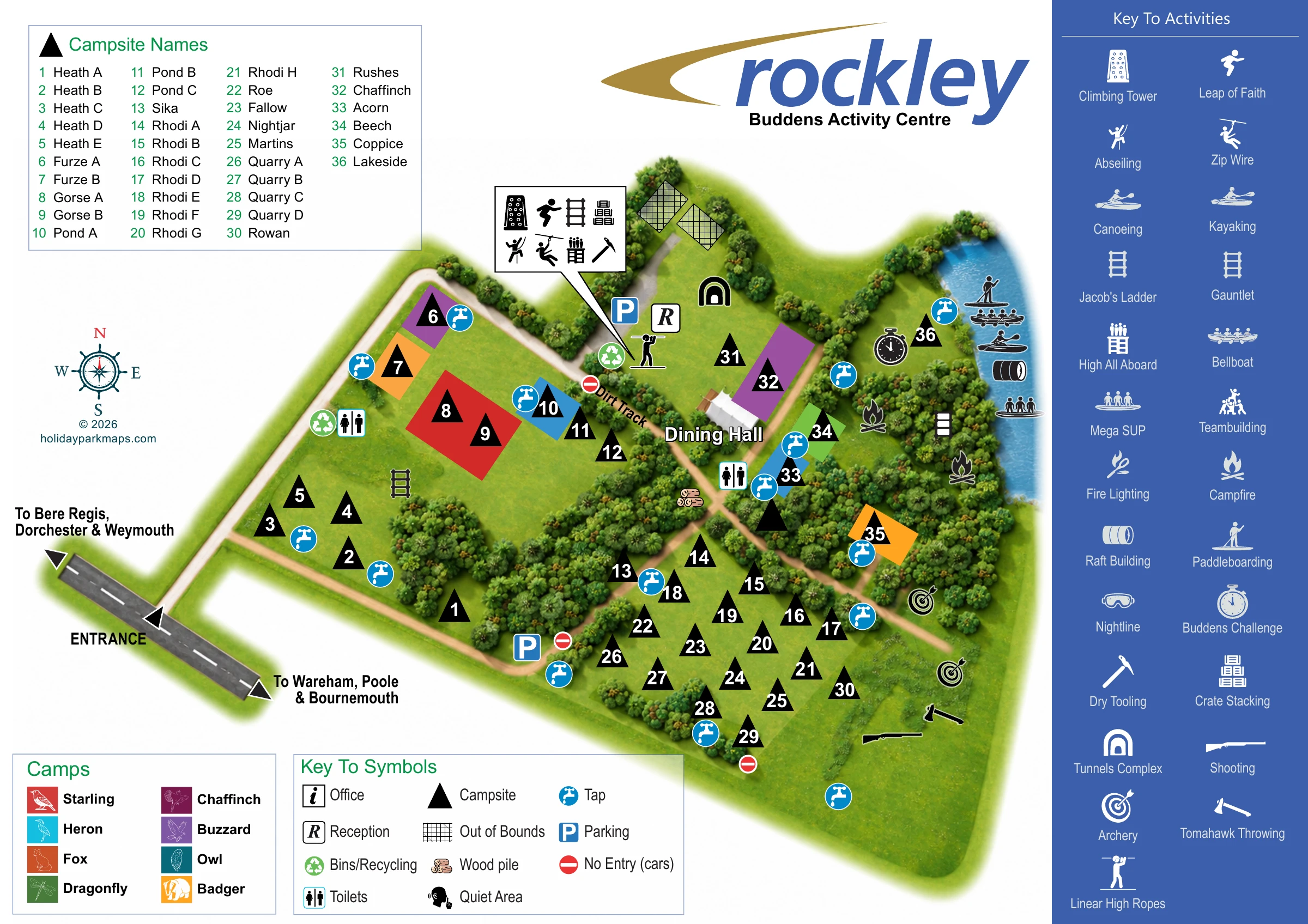
This illustrated map of Buddens Activity Centre near Wareham, Dorset, brings group camping and outdoor activities together on one visitor-facing plan. Rather than drawing individual tent pitches, it identifies named camping clearings across a landscape of grass, woodland and lakeside spaces. Bold numbered triangles link those areas to a campsite directory, while selected coloured blocks introduce a second, wildlife-themed camp identification system.
The entrance and road destinations are shown at the lower left, with internal routes leading towards reception, parking and the centrally placed dining hall. Water taps, toilets and recycling points provide practical landmarks among the camps. Along the lake, a sequence of watersports symbols distinguishes activities such as paddleboarding, kayaking and raft building from the land-based activity areas.
The page is framed by a large Rockley logo and a full-height blue activity key. Its combination of landscape illustration, simple service symbols and structured reference panels makes this a useful sample for activity centres and group campsites that need to explain both where visitors stay and where organised sessions take place.
The main plan occupies an irregular wedge of green landscape, with the entrance at the lower left and the lake along the right-hand edge. A broad pale access route follows the western boundary towards reception and an upper parking area. Tan tracks branch through the camping clearings, pass the dining hall and connect the wooded centre with the southern activity ground. External road arrows name destinations in both directions, while red vehicle-restriction symbols distinguish selected internal access points.
Camping areas are identified by large black triangles with white numbers. The upper-left directory translates these into names including Heath, Furze, Gorse, Pond, Rhodi and Quarry, alongside individually named areas such as Acorn, Beech, Coppice and Lakeside. Coloured camp blocks are supported by a separate key featuring wildlife names and line illustrations. These are area identifiers, not drawings of individual tent positions.
Dense tree belts create distinct pockets within the grounds. The dining hall forms a central landmark, with toilets and a wood pile nearby. Blue tap symbols recur throughout the plan, while recycling and parking markers provide further practical reference points.
Activities have their own visual hierarchy. A boxed callout near reception gathers climbing and aerial symbols, including climbing tower, zip wire and crate stacking. A tunnel symbol and linear high ropes appear nearby. Campfires and the Buddens Challenge sit closer to the lake, whose edge carries symbols for several paddling and raft activities. Archery, shooting and tomahawk throwing occupy the eastern and southern grounds.
The full-height blue activity sidebar explains the pictograms independently of the general service key. The accompanying detail views enlarge portions of these same reference panels; they are not separate maps or additional camping areas.
 Enlarge this map ↗
KEEP EXPLORING
Chosen for shared landscapes, accommodation or facilities.
 Explore the map ↗
United Kingdom
Ashby Park map with seven fishing lakes, colour-coded accommodation and illustrated wooded shorelines.
 Explore the map ↗
United Kingdom
Woodland camping, lodges, lakes and colour-coded bike trails at Avon Tyrrell Outdoor Centre.
 Explore the map ↗
United Kingdom
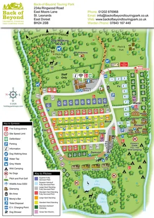
Colour-coded touring pitches, named glamping units and woodland routes at Back of Beyond Touring Park.
Features may come from the sample artwork, its key or published park information. Approximate numbers describe the drawing and may cover only part of a park. They are intended to help you compare map examples. Current facilities and booking information should be checked with the park.
LET’S MAP YOUR PARK
For a map quotation, find your park and draw a rough boundary around it. The area you select helps us work out the design time and price.
Draw your park for a quote ↗Or talk to our map designers
01751 473136