
Lake Eucumbene
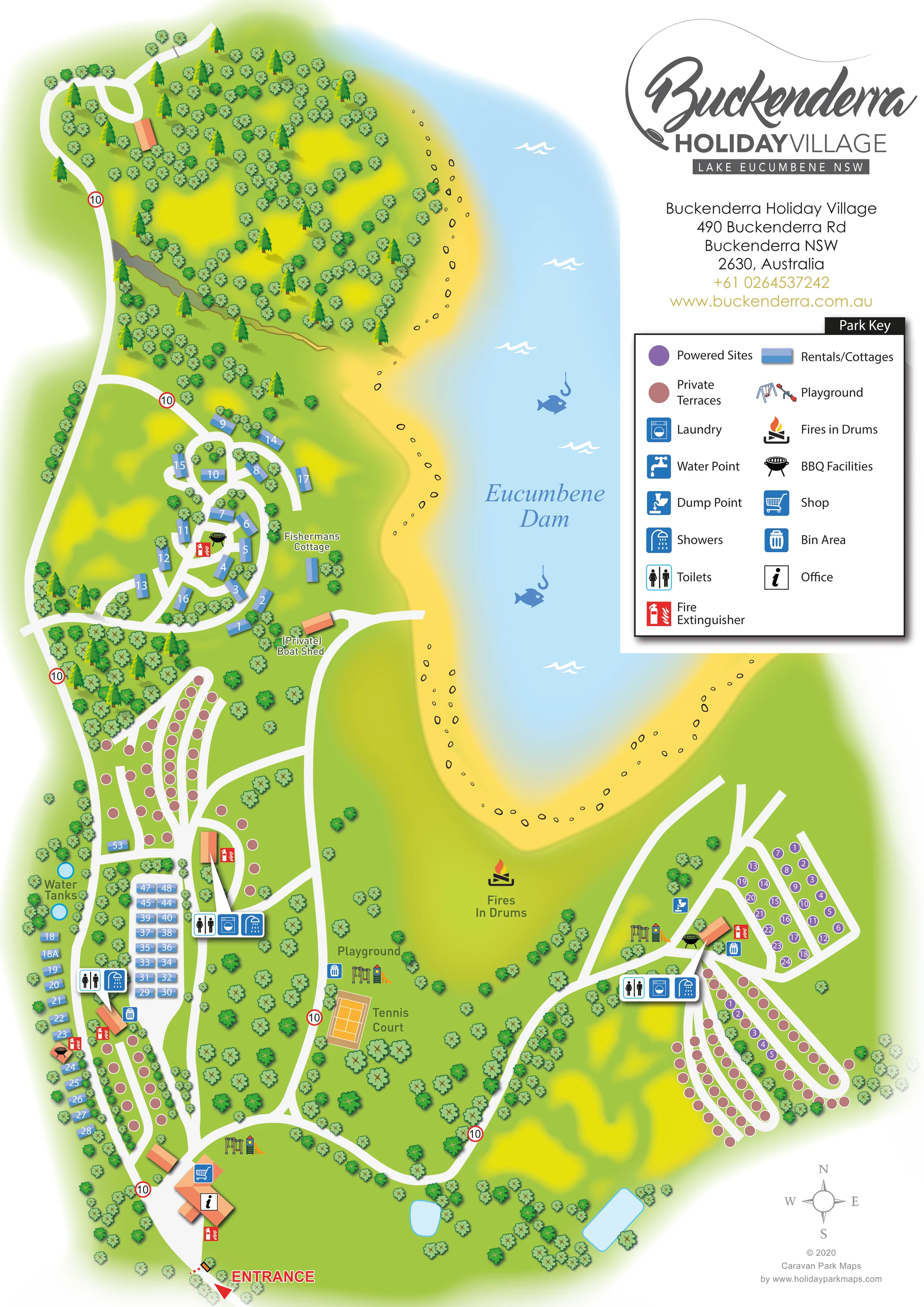
The large blue water body is labelled Eucumbene Dam and forms the central landscape feature, with accommodation and roads around its illustrated inlet.
ILLUSTRATED PARK MAP · P423
490 Buckenderra Road, Buckenderra NSW, Australia · Australia
 Enlarge the map ↗
A SENSE OF THE PLACE
Buckenderra Holiday Village is based at 490 Buckenderra Road, Buckenderra NSW, Australia. The site is set along eight kilometres of Lake Eucumbene foreshore in the Snowy Mountains, on over one hundred acres. The park offers self-contained two-bedroom Snowy Cottages, one-bedroom spa cabins and family ensuite cabins. Powered sites at Picnic Point have nearby toilets, showers and laundry; unpowered camping is unallocated over a large lakeside area.
The lake setting supports trout fishing, boating and other outdoor recreation. The office shop sells groceries, fuel, firewood, ice and fishing gear; hot food is seasonal.
LOOK CLOSER
The large blue water body is labelled Eucumbene Dam and forms the central landscape feature, with accommodation and roads around its illustrated inlet.
A broad yellow shoreline with scattered outlined stones follows the water's edge; wave and hooked-fish motifs reinforce the lakeside setting.
Dense tree symbols occupy the northern peninsula and border accommodation roads, with more open green space in the centre.
Two unlabelled blue water shapes appear near the southern boundary; their purpose is not stated.
A red arrow and ENTRANCE label mark arrival at the bottom of the plan, beside the office and shop buildings.
White roads divide from the southern arrival area into western accommodation routes, central recreation space and eastern loops. Repeated circular 10 signs are drawn along the network.
Information and shopping-trolley symbols identify the arrival buildings near the entrance.
Grouped toilet, shower and laundry symbols mark amenity provision in the western accommodation areas and beside the eastern site groups.
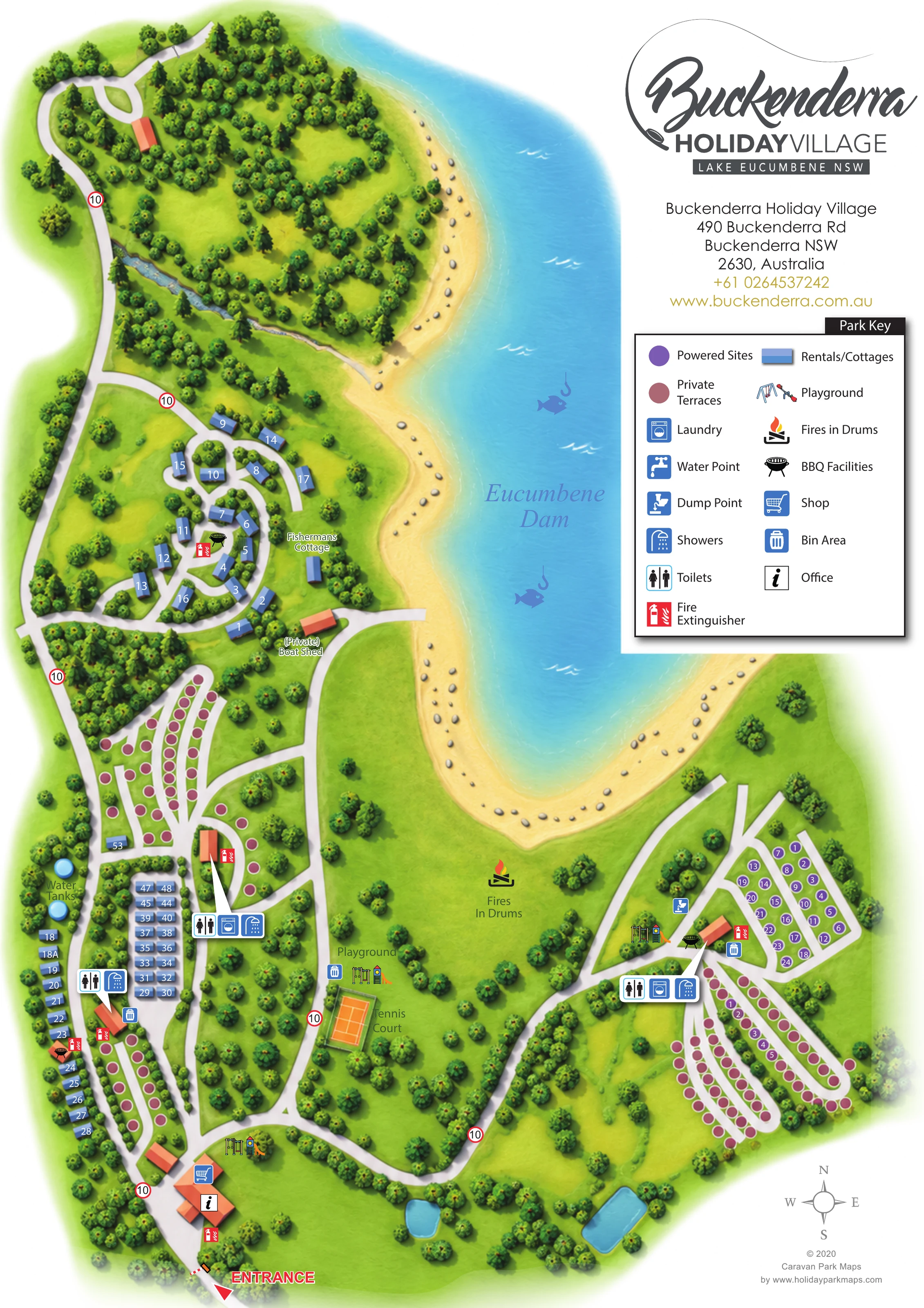
The large blue water body is labelled Eucumbene Dam and forms the central landscape feature, with accommodation and roads around its illustrated inlet.
A broad yellow shoreline with scattered outlined stones follows the water's edge; wave and hooked-fish motifs reinforce the lakeside setting.
Dense tree symbols occupy the northern peninsula and border accommodation roads, with more open green space in the centre.
Two unlabelled blue water shapes appear near the southern boundary; their purpose is not stated.
A red arrow and ENTRANCE label mark arrival at the bottom of the plan, beside the office and shop buildings.
White roads divide from the southern arrival area into western accommodation routes, central recreation space and eastern loops. Repeated circular 10 signs are drawn along the network.
Information and shopping-trolley symbols identify the arrival buildings near the entrance.
Grouped toilet, shower and laundry symbols mark amenity provision in the western accommodation areas and beside the eastern site groups.
A blue dump-point symbol is positioned on the approach to the eastern powered-site area.
A tap symbol is explained in the Park Key, but no corresponding on-plan location is clearly identifiable.
Two blue circles labelled Water Tanks appear along the western side of the accommodation area.
Blue bin symbols recur beside accommodation and recreation areas.
Red extinguisher symbols are distributed beside buildings and shared facilities.
Black barbecue illustrations mark shared facilities in the northern rental loop and beside western and eastern accommodation.
A large fire-in-drum illustration and label appear in the central open space below the lakeshore. The artwork identifies the feature without establishing current fire conditions or permissions.
Play equipment is illustrated in the central recreation area, near the entrance and beside the eastern amenity area.
A labelled orange court with white playing lines sits beside the central playground and main internal road.
An orange-roofed building near the western foreshore is labelled (Private) Boat Shed.
A named blue rental building stands apart from the northern accommodation loop, towards the lake.
Operator information describes trout fishing and boating on Lake Eucumbene; hooked-fish illustrations provide a related visual theme on the map.
READING THE MAP
This illustrated map of Buckenderra Holiday Village places Lake Eucumbene at the heart of the visitor experience. Set in the Snowy Mountains of New South Wales, the park is presented as a series of accommodation areas and recreation spaces around a curving lakeshore, with a wooded peninsula extending towards the top of the page. Pale blue water, golden shoreline and green grounds make the setting immediately recognisable, while small fish-and-hook illustrations introduce its fishing character.
The map uses three clear accommodation treatments: blue blocks for rentals and cottages, purple circles for powered sites, and rose circles for private terraces. White roads connect these groups to the southern entrance, office and shop. Shared amenities, playgrounds, barbecue facilities and a tennis court are picked out with symbols and illustrations, giving visitors useful landmarks beyond their accommodation number.
A substantial logo and Park Key occupy the right-hand side of the portrait page. This sample demonstrates how a landscape-led park map can combine a dispersed site layout, several accommodation categories and practical visitor information without losing the identity of its lakeside setting.
The plan begins at a clearly marked entrance near the bottom of the page, where orange-roofed buildings carry office and shop symbols. From here, broad white roads branch through the grounds. One route follows the western accommodation areas towards a northern rental loop; another crosses the lower central landscape to serve the eastern powered sites and private terraces. Short branches approach the lake, including the road beside the labelled private boat shed.
Accommodation is organised through contrasting shapes and colours. Blue rentals and cottages appear around a rounded northern loop, along the western edge and in a compact block of paired rows. Fishermans Cottage is named separately near the foreshore. Rose private-terrace circles line several narrow lanes on both sides of the park. Purple powered-site markers form an eastern group, with a smaller cluster among the terraces below it.
Grouped toilet, shower and laundry symbols identify shared amenity areas. Other mapped symbols locate bins, fire extinguishers, barbecues and an eastern dump point. Play equipment appears in several parts of the grounds, while a labelled tennis court and playground occupy the central recreation space. A prominent fires-in-drums illustration sits nearer the shore, and water tanks are labelled on the western side.
The lake, labelled Eucumbene Dam, is drawn with a sweeping yellow foreshore, small stones, white wave marks and hooked-fish motifs. Tree symbols provide texture and separate accommodation groups. The upper-right branding and contact panel leads into a large two-column Park Key; a compass and designer credit complete the lower-right margin. The accompanying detail view enlarges that same legend and eastern site area, rather than depicting another section or a separate map.
 Enlarge this map ↗
KEEP EXPLORING
Chosen for shared landscapes, accommodation or facilities.
 Explore the map ↗
United Kingdom
Ashby Park map with seven fishing lakes, colour-coded accommodation and illustrated wooded shorelines.
 Explore the map ↗
United Kingdom
Woodland park map with mixed pitches, bell tents, lodges and a fishing lake.
 Explore the map ↗
France
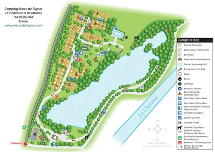
Bilingual lakeside campsite map with numbered pitches, recreation areas and colour-coded service points.
Features may come from the sample artwork, its key or published park information. Approximate numbers describe the drawing and may cover only part of a park. They are intended to help you compare map examples. Current facilities and booking information should be checked with the park.
TAKE A CLOSER LOOK
View the illustrated map in detail or choose a file to download. These are sample maps; contact the park for current visitor information.


LET’S MAP YOUR PARK
For a map quotation, find your park and draw a rough boundary around it. The area you select helps us work out the design time and price.
Draw your park for a quote ↗Or talk to our map designers
01751 473136
 buckenderra_large.png