
Arthurs Pool
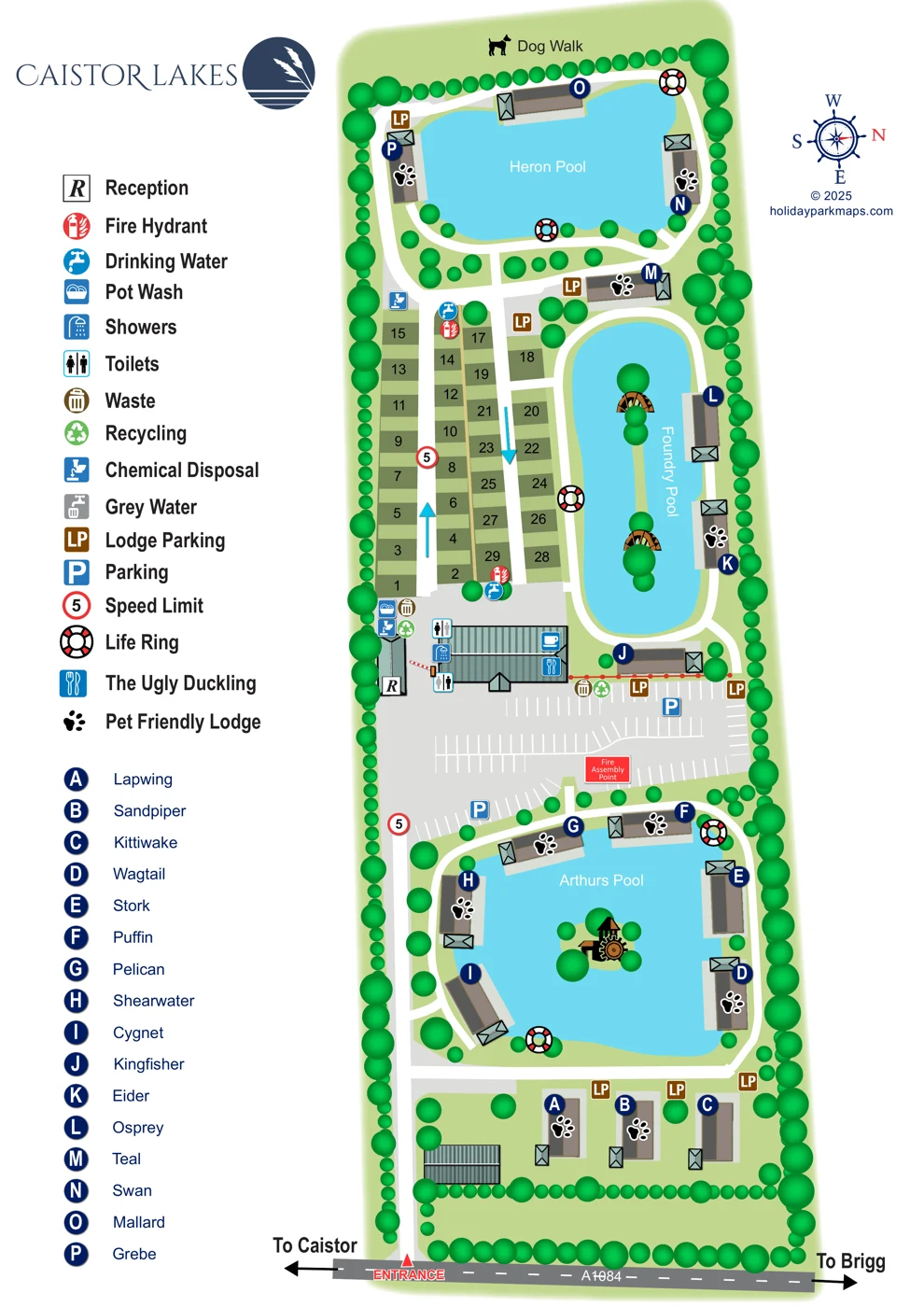
Broad lower pool with lodges around its banks and an illustrated tree-covered central island feature.
ILLUSTRATED PARK MAP · P056
99a Brigg Road, Caistor, near Market Rasen · United Kingdom
 Enlarge the map ↗
A SENSE OF THE PLACE
Caistor Lakes is a family-run leisure park near Caistor in Lincolnshire. It combines adults-only self-catering accommodation, touring hardstandings and fishing lakes in a countryside setting.
Lakeside lodges and an on-site restaurant provide options for a break focused on comfort and time by the water. The park map shows how its accommodation, fishing and shared facilities are arranged across the site.
LOOK CLOSER
Broad lower pool with lodges around its banks and an illustrated tree-covered central island feature.
Long middle pool beside the touring area, with bank-side lodges and small illustrated island features.
Upper pool bordered by paths, trees and several lakeside lodges.
Dense tree rows enclose the site, with scattered trees and planted islands adding separation and visual character.
Labelled walking area along the far boundary above Heron Pool.
Reception marker on a small building beside the main shared facilities and touring-area access.
Restaurant identified by its cutlery symbol on the central building adjoining the main parking area.
Toilet and shower symbols grouped around the central facilities building near the touring pitches.
Three named fishing pools form the principal landscape and accommodation landmarks; the fishing use is supported by the park context.
Broad lower pool with lodges around its banks and an illustrated tree-covered central island feature.
Long middle pool beside the touring area, with bank-side lodges and small illustrated island features.
Upper pool bordered by paths, trees and several lakeside lodges.
Labelled walking area along the far boundary above Heron Pool.
Reception marker on a small building beside the main shared facilities and touring-area access.
Restaurant identified by its cutlery symbol on the central building adjoining the main parking area.
Toilet and shower symbols grouped around the central facilities building near the touring pitches.
Pot-wash point shown beside the lower end of the touring area.
Repeated drinking-water symbols serve the touring area.
Chemical-disposal symbols appear at the upper and lower ends of the touring section.
Grey-water disposal has a dedicated symbol in the legend; a corresponding location is not clearly identifiable on the plan.
Waste and recycling symbols are grouped near the touring facilities and central parking area.
Large central parking area drawn with individual bay markings and blue parking symbols.
Brown LP symbols distinguish lodge parking from general visitor parking.
Paw symbols mark selected lodges as pet friendly on the map; this is an accommodation designation rather than a park-wide policy.
Fire-hydrant symbols appear beside the touring pitches.
A red fire assembly point label is placed within the central parking area.
Repeated life-ring symbols are positioned around the three pools.
Entrance from the A1084, with road arrows labelled towards Caistor and Brigg.
Internal roads and pale lakeside routes link the accommodation areas; blue arrows indicate circulation in the touring lanes, and 5 speed-limit symbols are shown.
Dense tree rows enclose the site, with scattered trees and planted islands adding separation and visual character.
READING THE MAP
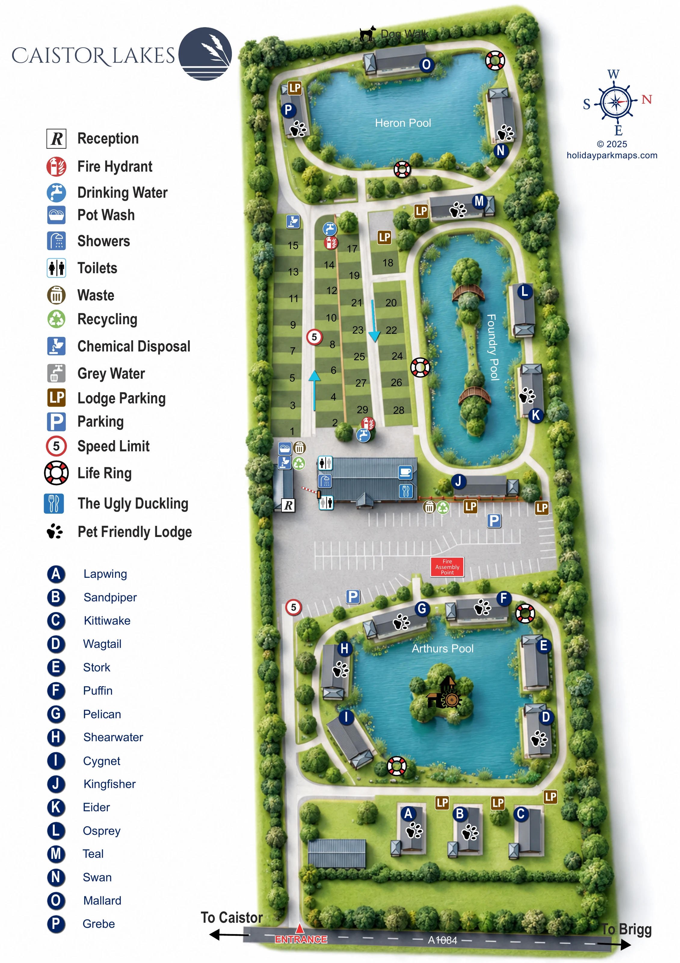
Water is the organising feature of this illustrated map for Caistor Lakes in Lincolnshire. Three clearly named pools—Arthurs Pool, Foundry Pool and Heron Pool—provide the main landmarks, with lakeside lodges, touring pitches and shared facilities arranged around them. The result is a particularly useful example of a map that needs to explain both accommodation choices and the shape of a waterside leisure park.
The tall portrait composition follows the site from its A1084 entrance to the dog walk at the far end. A central parking and restaurant area creates a clear point of reference between the lower lodge area and the touring section. Bird-named lodges are identified by navy letter markers linked to a dedicated directory, while touring pitches use simple numbered blocks.
Bright blue water, rounded green trees and restrained building colours separate the main landscape elements at a glance. The large side legend brings together everyday facilities, parking and safety symbols, allowing the detailed plan to remain readable without filling each area with long labels.
The plan occupies a tall, narrow strip beside an extensive left-hand legend. At the bottom, the A1084 is drawn as a grey road with dashed white markings, an entrance arrow and directions towards Caistor and Brigg. An internal route follows the left side of the park into a broad central parking area, where reception, The Ugly Duckling restaurant and shared visitor facilities are grouped.
Three turquoise pools structure the accommodation layout. Arthurs Pool occupies the lower section, with lodges along its banks and another small lodge group between the pool and the entrance. Foundry Pool forms a long, narrow water feature in the middle-right of the plan, opposite parallel rows of touring pitches. Heron Pool sits at the upper end, enclosed by paths, trees and lakeside lodges. A labelled dog walk runs along the far boundary above it.
The lodges are illustrated as elongated taupe buildings with small pale green roof or terrace details. Navy letter markers link them to a directory of bird names, including Lapwing, Kingfisher and Grebe. Paw symbols identify selected lodges as pet friendly in the artwork, while brown LP markers distinguish lodge parking. Touring pitches appear as numbered olive rectangles, with blue arrows indicating circulation through their access lanes.
Symbols locate drinking water, fire hydrants, pot washing, chemical disposal, toilets, showers, waste and recycling. Life rings punctuate the pool edges, and a fire assembly point is marked within the central parking area. Dense rounded trees frame the boundary and soften the spaces between routes and accommodation. Small illustrated islands and ornamental features add character to the water without competing with the practical labels.
 Enlarge this map ↗
KEEP EXPLORING
Chosen for shared landscapes, accommodation or facilities.
 Explore the map ↗
United Kingdom
Illustrated farm holiday park plan combining riverside pitches, lakeside accommodation, animal fields and paw-print walking routes, with separate accommodation and facilities keys.
 Explore the map ↗
United Kingdom
Ashby Park map with seven fishing lakes, colour-coded accommodation and illustrated wooded shorelines.
 Explore the map ↗
United Kingdom
Woodland park map with mixed pitches, bell tents, lodges and a fishing lake.
Features may come from the sample artwork, its key or published park information. Approximate numbers describe the drawing and may cover only part of a park. They are intended to help you compare map examples. Current facilities and booking information should be checked with the park.
LET’S MAP YOUR PARK
For a map quotation, find your park and draw a rough boundary around it. The area you select helps us work out the design time and price.
Draw your park for a quote ↗Or talk to our map designers
01751 473136