
Grassy open space
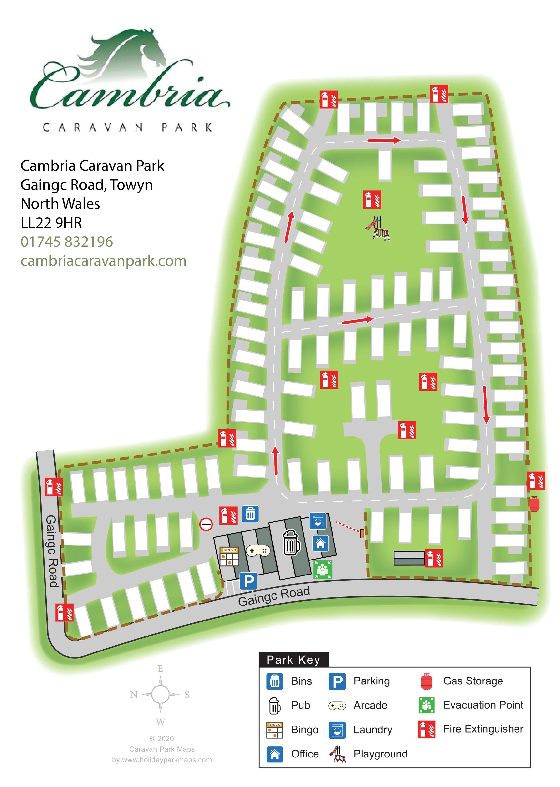
Light-green ground surrounds the caravan footprints, including a larger open area around the playground within the upper loop.
ILLUSTRATED PARK MAP · P434
Cambria Caravan Park, Gaingc Road, Towyn, North Wales · United Kingdom
 Enlarge the map ↗
A SENSE OF THE PLACE
Cambria Caravan Park is a family-run holiday park at Towyn in North Wales. Its static caravan setting provides a base for time on the coast and visits to the surrounding area.
The park also advertises a centrally heated, double-glazed caravan for holiday hire. The site map gives visitors and holiday homeowners an overview of the accommodation areas and access routes.
LOOK CLOSER
Light-green ground surrounds the caravan footprints, including a larger open area around the playground within the upper loop.
A brown dashed perimeter encloses the irregular site, with a soft green halo separating it from the white page.
Blue house symbol on the communal building cluster beside the entrance barrier.
Beer-mug symbol identifies a pub within the roadside communal buildings.
Bingo-card symbol marks the left-hand portion of the communal building cluster.
Game-controller symbol identifies an arcade alongside the bingo and pub facilities.
Washing-machine symbol appears on the entrance-side building near the office.
Blue parking symbol and a short row of marked bays are shown in front of the communal buildings beside Gaingc Road.
Blue house symbol on the communal building cluster beside the entrance barrier.
Beer-mug symbol identifies a pub within the roadside communal buildings.
Bingo-card symbol marks the left-hand portion of the communal building cluster.
Game-controller symbol identifies an arcade alongside the bingo and pub facilities.
Washing-machine symbol appears on the entrance-side building near the office.
Blue parking symbol and a short row of marked bays are shown in front of the communal buildings beside Gaingc Road.
A small illustrated slide and swings mark the playground in the broad grassy space inside the upper road loop.
A blue bin symbol marks a disposal point beside the internal road near the communal buildings.
Red gas-cylinder symbol marks storage along the right-hand perimeter in the lower part of the plan.
Repeated red fire-extinguisher symbols are distributed around the perimeter, accommodation roads and communal area.
Green assembly-style symbol identifies an evacuation point immediately beside the communal buildings.
The named public road curves around the lower and left-hand edges of the depicted site.
A red-and-white barrier is illustrated across the access beside the office and laundry building.
Grey roads with white dashed centre lines form a long loop, a cross-link and shorter branches. Red arrows indicate travel direction, with a no-entry symbol near the smaller roadside section.
Light-green ground surrounds the caravan footprints, including a larger open area around the playground within the upper loop.
A brown dashed perimeter encloses the irregular site, with a soft green halo separating it from the white page.
READING THE MAP
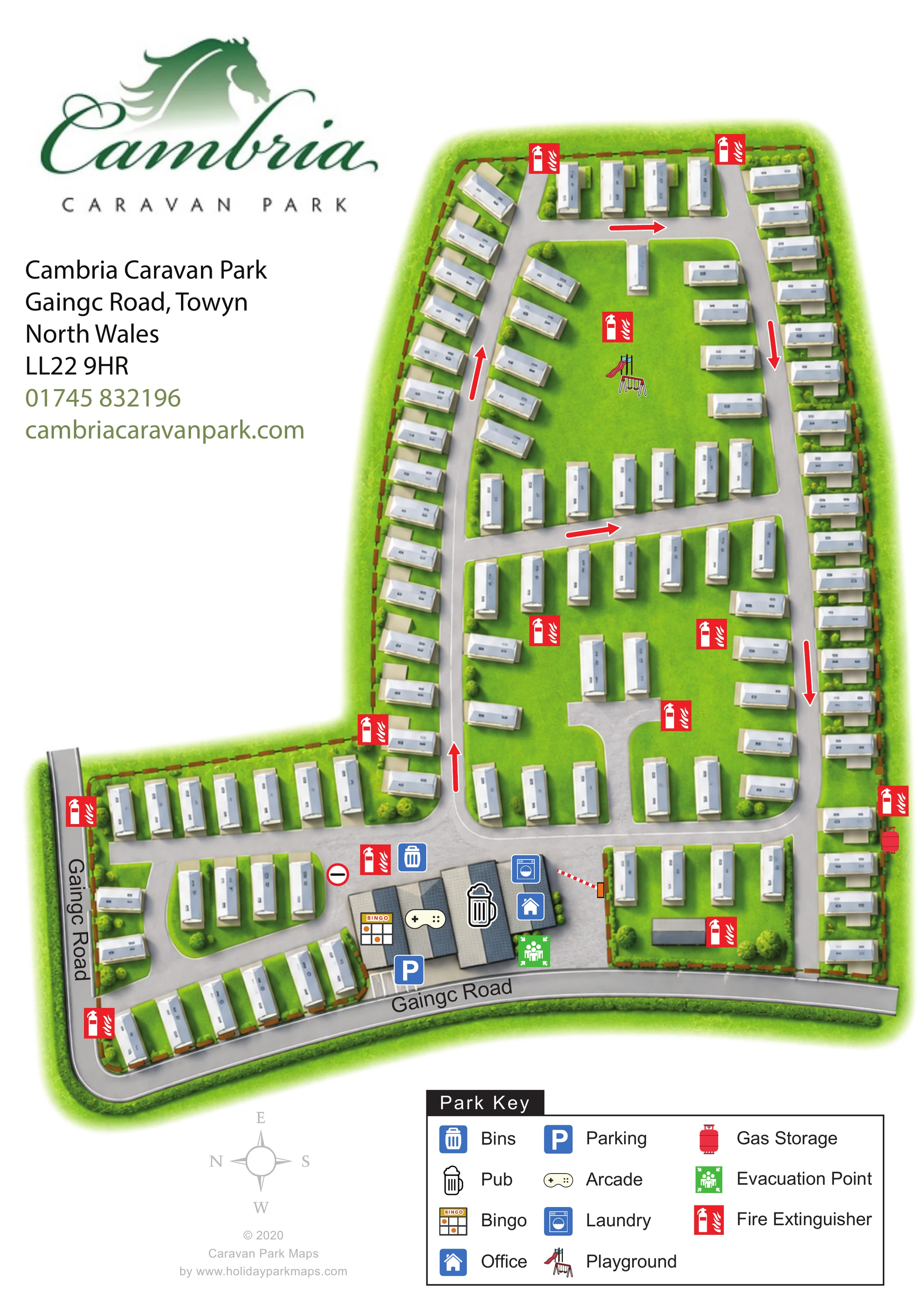
This map of Cambria Caravan Park in Towyn, North Wales, presents a static-caravan site through a clear overhead plan. Gaingc Road curves around the lower and left-hand edges, while the accommodation extends into a long enclosure above the entrance buildings. White caravan footprints sit against green lawns, making the relationship between roadside rows, interior groups and open space easy to follow.
The design gives particular attention to movement through the park. Grey roads, dashed centre lines and bold red arrows explain the internal circulation, while a barrier marks the entrance beside the office. The pub, bingo, arcade and laundry are grouped in the same roadside building area, and a playground sits within the larger green space further into the site.
A prominent green Cambria logo anchors the upper-left corner, with the address and contact details beneath it. The large Park Key brings together everyday services and safety symbols without covering the accommodation layout. This is a useful sample for a caravan park needing a branded site overview focused on routes, shared facilities and the arrangement of accommodation rather than individual pitch numbers.
The artwork is a single portrait site plan, with an elongated main enclosure and a smaller accommodation section extending towards the left beside Gaingc Road. The road is labelled along both visible sides of the frontage. Near the lower centre, a cluster of grey and muted green-grey buildings carries symbols for bingo, arcade, pub, laundry and office. Marked parking bays face the road, and a red-and-white barrier identifies the adjacent access.
Inside the park, a broad grey road rises along the left side, bends across the top and returns down the right. White dashed centre lines and red directional arrows make this loop visually distinct from the surrounding lawns. A diagonal cross-link divides the middle accommodation groups, while shorter branches serve the lower rows and the compact roadside section. A no-entry symbol is shown near the junction by the communal buildings.
Approximately 110 caravan footprints are depicted as white rectangles with pale-grey bases. Units follow the perimeter and internal roads, changing orientation to fit angled boundaries and bends. The upper loop contains a generous green space with a small slide-and-swings illustration marking the playground.
Fire-extinguisher symbols recur throughout the site. Bins are marked near the communal area, gas storage appears on the right-hand boundary, and an evacuation point is shown beside the buildings. The bottom-right key explains all these symbols in three columns. A pale compass beneath the plan shows north pointing left. The large Cambria horse-head logo and contact block occupy the open upper-left area. The accompanying detail views enlarge the same footer and legend; they are not separate park sections or alternative maps.
 Enlarge this map ↗
KEEP EXPLORING
Chosen for shared landscapes, accommodation or facilities.
 Explore the map ↗
United Kingdom
Coastal park map with static-caravan rows, touring pitches, a camping field and two leisure clusters.
 Explore the map ↗
United Kingdom
A wooded Allerton park plan with colour-coded neighbourhoods, touring pitches and a central facilities hub.
 Explore the map ↗
United Kingdom
Illustrated coastal holiday-home plan with dense alphanumeric plot labels, orange-roofed amenities, a numbered facility key and beach-side context.
Features may come from the sample artwork, its key or published park information. Approximate numbers describe the drawing and may cover only part of a park. They are intended to help you compare map examples. Current facilities and booking information should be checked with the park.
TAKE A CLOSER LOOK
View the illustrated map in detail or choose a file to download. These are sample maps; contact the park for current visitor information.


LET’S MAP YOUR PARK
For a map quotation, find your park and draw a rough boundary around it. The area you select helps us work out the design time and price.
Draw your park for a quote ↗Or talk to our map designers
01751 473136