
Railway corridor
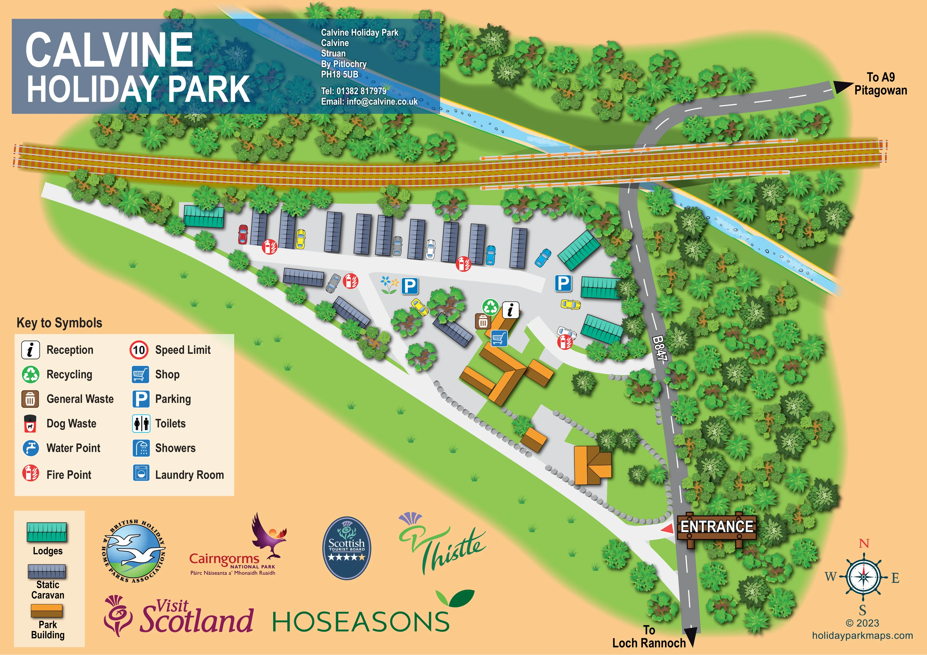
A prominent twin-track railway runs across the upper portion of the artwork, immediately beyond the accommodation strip and across the road and watercourse.
ILLUSTRATED PARK MAP · P057
Calvine Holiday Park, Calvine, Struan, By Pitlochry · United Kingdom
 Enlarge the map ↗
A SENSE OF THE PLACE
Calvine Holiday Park is a family-owned caravan and lodge park near Blair Atholl and Pitlochry, within the Cairngorms National Park. It offers holiday accommodation and a range of new and pre-owned holiday homes for sale.
The park's location near the A9 makes it a base for exploring Highland Perthshire. Dogs are welcomed, and the surrounding walking routes and scenery are central to the appeal of a stay.
LOOK CLOSER
A prominent twin-track railway runs across the upper portion of the artwork, immediately beyond the accommodation strip and across the road and watercourse.
An unnamed pale-blue watercourse crosses diagonally through the upper landscape, with illustrated stones and light ripples.
Dense mixed tree symbols frame the railway, watercourse and eastern road, while smaller planted groups divide accommodation and service areas.
A broad grassy margin borders the western side, and rows of grey stones define parts of the southern building and arrival area.
An information symbol identifies reception at the central orange park-building cluster.
A blue shopping-trolley symbol marks the shop beside the central park buildings.
Two blue parking markers appear along the internal accommodation route; illustrated cars also help explain the vehicle-access layout.
General-waste and recycling symbols are grouped beside reception.
An information symbol identifies reception at the central orange park-building cluster.
A blue shopping-trolley symbol marks the shop beside the central park buildings.
Two blue parking markers appear along the internal accommodation route; illustrated cars also help explain the vehicle-access layout.
General-waste and recycling symbols are grouped beside reception.
Repeated red fire-point symbols are distributed around the caravan row and eastern lodge area.
Included in the symbol key, but no corresponding location is clearly marked on the main plan.
A shower symbol is explained in the key without a clearly identifiable position on the main plan.
Listed in the key; its location is not clearly indicated on the plan.
The key includes a water-point symbol, but the plan does not clearly locate one.
A dog-waste symbol appears in the key without a clearly visible mapped position.
The legend illustrates a red-ringed 10 speed-limit sign; it is not visibly positioned on the main plan.
Orange-roofed buildings occupy the central and southern arrival area. Reception and shop are identified, while the other buildings are not individually named.
A prominent timber-style ENTRANCE sign and red pointer mark the access on the lower-right edge of the park.
The B847 runs beside the eastern boundary, with arrows towards the A9 and Pitagowan at the top and Loch Rannoch at the bottom.
Broad pale routes connect the entrance, park buildings and accommodation, including a long lane serving the northern caravan row.
A prominent twin-track railway runs across the upper portion of the artwork, immediately beyond the accommodation strip and across the road and watercourse.
An unnamed pale-blue watercourse crosses diagonally through the upper landscape, with illustrated stones and light ripples.
Dense mixed tree symbols frame the railway, watercourse and eastern road, while smaller planted groups divide accommodation and service areas.
A broad grassy margin borders the western side, and rows of grey stones define parts of the southern building and arrival area.
READING THE MAP
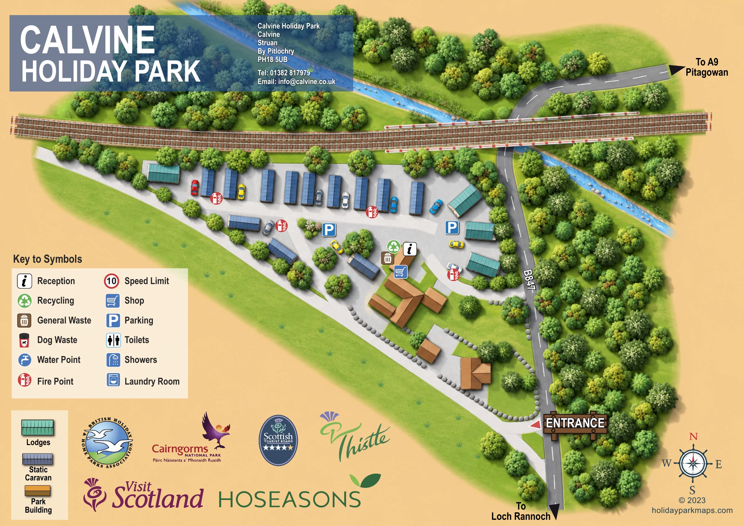
This illustrated map of Calvine Holiday Park presents a compact caravan and lodge park in a distinctly wooded Highland setting. Located at Calvine, Struan, by Pitlochry, the park is shown beside the B847, with a railway stretching across its northern edge and a blue watercourse running diagonally through the surrounding trees. These larger landscape features give the plan a recognisable setting rather than leaving the accommodation isolated on a blank background.
The map uses grey roofs for static caravans, turquoise for lodges and orange for park buildings. A clear entrance marker leads visitors into pale internal lanes, with reception, shop, parking and fire-point symbols providing the main practical landmarks. Most accommodation follows a simple upper row, while the arrival buildings sit below it in a more open, stone-edged area.
A peach background, detailed tree canopies and a large title panel give the page its character. Separate keys explain facilities and building types, making this a useful sample for smaller holiday parks that need to combine straightforward arrival guidance with an illustrated sense of place.
The complete artwork is a landscape-format plan arranged around a roughly triangular site west of the B847. The entrance sits near the lower-right corner, marked by a timber-style sign and red pointer. From here, pale internal lanes pass the southern orange-roofed buildings and continue towards the central reception and shop cluster. Grey stones edge parts of the arrival grounds, helping distinguish these open spaces from the surrounding grass.
Accommodation occupies the upper part of the park. A regular row of grey static-caravan roofs runs beneath the railway, with a few additional caravans angled around the central lanes. Turquoise lodges appear at the western end and along the eastern side. Illustrated cars, two parking symbols and small planted islands make the circulation pattern easy to recognise. Red fire-point markers are spread around the accommodation, while waste and recycling symbols sit beside reception.
Beyond the units, a twin-track railway crosses the page almost horizontally. A pale-blue watercourse cuts diagonally through dense woodland, and the B847 curves through the eastern landscape. Directional arrows point towards the A9 and Pitagowan above, and Loch Rannoch below. A compass occupies the lower-right corner.
The upper-left title and contact panel overlaps the landscape in translucent blue-grey. Below it, a cream facility key explains the symbols, while a second key distinguishes lodges, static caravans and park buildings. Toilets, showers, laundry, water points, dog waste and a speed-limit sign appear in the key without clear positions on the plan. Tourism and industry logos fill the remaining lower-left space. The accompanying detail view enlarges this same legend and branding area; it is not a separate park section.
 Enlarge this map ↗
KEEP EXPLORING
Chosen for shared landscapes, accommodation or facilities.
 Explore the map ↗
United Kingdom
A woodland holiday-park plan with numbered homes, tree-named roads, walking loops and a distinctive entrance totem pole.
 Explore the map ↗
United Kingdom
Illustrated lakeside park plan with numbered holiday units, leisure buildings and a looping Woodland Walk.
 Explore the map ↗
United Kingdom
Portrait holiday-home park map with riverside loops, a tree-fringed pond and a separate manor landmark.
Features may come from the sample artwork, its key or published park information. Approximate numbers describe the drawing and may cover only part of a park. They are intended to help you compare map examples. Current facilities and booking information should be checked with the park.
LET’S MAP YOUR PARK
For a map quotation, find your park and draw a rough boundary around it. The area you select helps us work out the design time and price.
Draw your park for a quote ↗Or talk to our map designers
01751 473136