
Wooded perimeter and internal planting
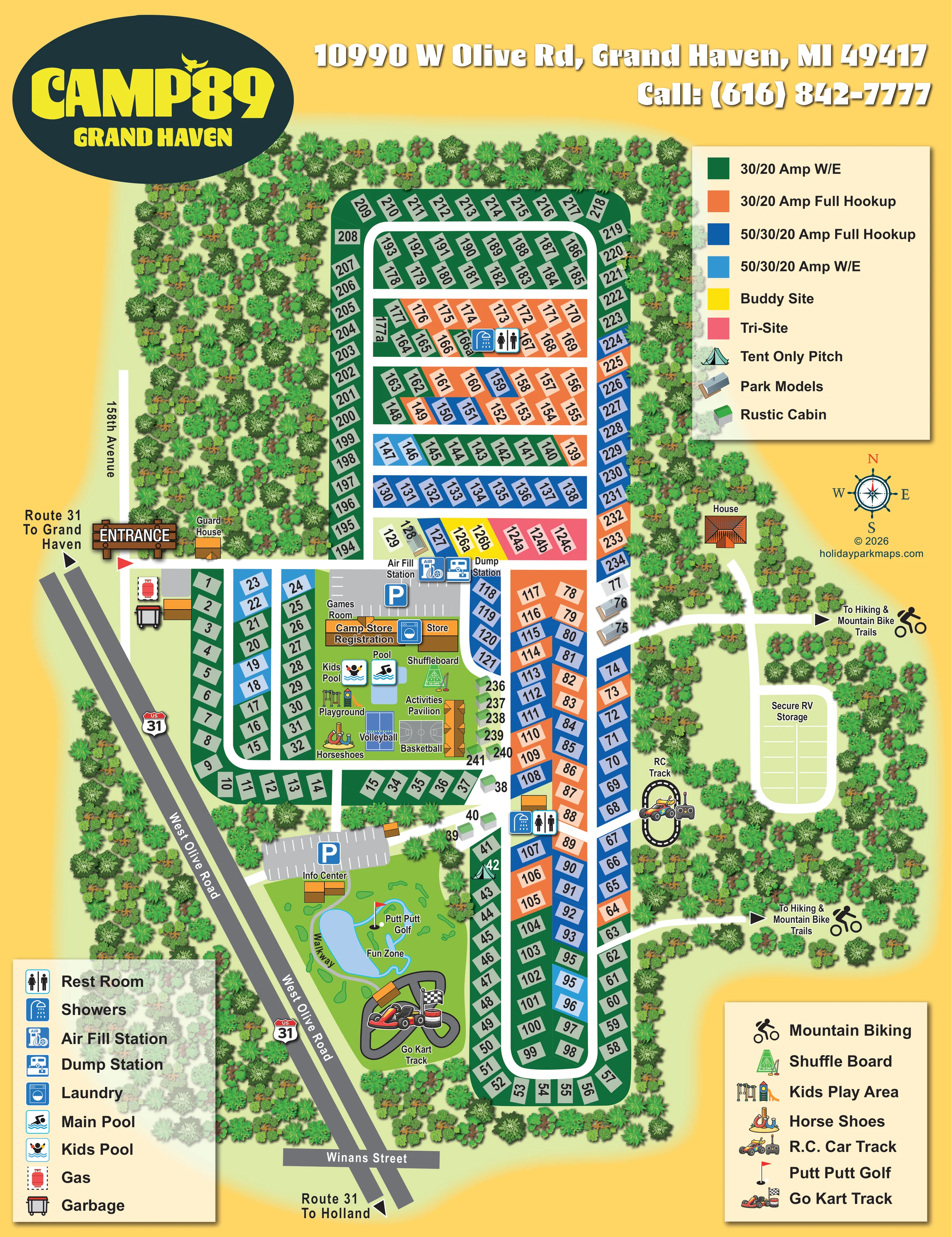
Dense illustrated trees surround the accommodation and separate the eastern tracks, storage area and trail connections.
ILLUSTRATED PARK MAP · P059
Grand Haven, Michigan, USA · United States
 Enlarge the map ↗
A SENSE OF THE PLACE
Camp '89 Grand Haven provides RV sites, cabins and tent camping near Lake Michigan. Full-hookup RV options sit alongside practical facilities such as heated restrooms, showers, laundry and a convenience store.
Published booking information describes pools, a playground, miniature golf and other family activities. Grand Haven's beach, lighthouse and boardwalk, together with nearby parks and trails, provide options for days away from the campground.
LOOK CLOSER
Dense illustrated trees surround the accommodation and separate the eastern tracks, storage area and trail connections.
A blue pond-like feature with narrow winding extensions sits within the Fun Zone. A grey route labelled Walkway curves around its western side.
A large timber-style entrance sign, red flag and labelled guard house mark arrival from the western roadside.
West Olive Road, 158th Avenue and Winans Street provide external context. Route 31 shields and arrows towards Grand Haven and Holland appear on the artwork.
Broad white routes connect the entrance, northern pitch grid, central amenities, southern elongated loop and eastern service areas.
The central building group is labelled Camp Store, Registration and Store, directly beside the main parking area.
A games room is labelled at the western end of the central store and registration building group.
Grey parking areas with white bay lines and blue P symbols are shown beside registration and the information centre.
A large timber-style entrance sign, red flag and labelled guard house mark arrival from the western roadside.
West Olive Road, 158th Avenue and Winans Street provide external context. Route 31 shields and arrows towards Grand Haven and Holland appear on the artwork.
Broad white routes connect the entrance, northern pitch grid, central amenities, southern elongated loop and eastern service areas.
The central building group is labelled Camp Store, Registration and Store, directly beside the main parking area.
A games room is labelled at the western end of the central store and registration building group.
Grey parking areas with white bay lines and blue P symbols are shown beside registration and the information centre.
Paired restroom and shower symbols identify service points within the northern accommodation grid and beside the southern pitch rows.
A blue washing-machine symbol places laundry at the central store and registration complex.
Labelled air fill and dump stations sit on the northern edge of the registration parking area.
Gas-cylinder and rubbish-container symbols are positioned just inside the western entrance.
Separate pool and kids pool labels and swimming symbols appear in the central recreation area.
A colourful climbing-frame and slide illustration marks the playground beside the pools.
A long orange-roofed pavilion forms the eastern edge of the central sports and recreation space.
Individually drawn and labelled basketball and volleyball courts sit alongside the activities pavilion.
Both games are labelled and illustrated within the central recreation area.
The Info Center is shown beside a separate parking area at the northern end of the southern leisure zone.
Miniature golf is illustrated with green course shapes and a red golf flag in the southern leisure area.
A named Fun Zone occupies the landscaped area around the blue water feature and miniature golf.
A looping grey track, oversized kart illustration, tyre stack and chequered flag distinguish the southern go-kart attraction.
A small oval RC track with a car and controller illustration lies east of the southern accommodation rows.
A separate rounded storage area with marked bays is labelled Secure RV Storage in the eastern woodland.
An orange-roofed building labelled House stands near the upper eastern access route; its function is not further specified.
Two eastward arrows, route branches and cyclist symbols indicate connections to hiking and mountain-bike trails beyond the main campground plan.
Dense illustrated trees surround the accommodation and separate the eastern tracks, storage area and trail connections.
A blue pond-like feature with narrow winding extensions sits within the Fun Zone. A grey route labelled Walkway curves around its western side.
READING THE MAP
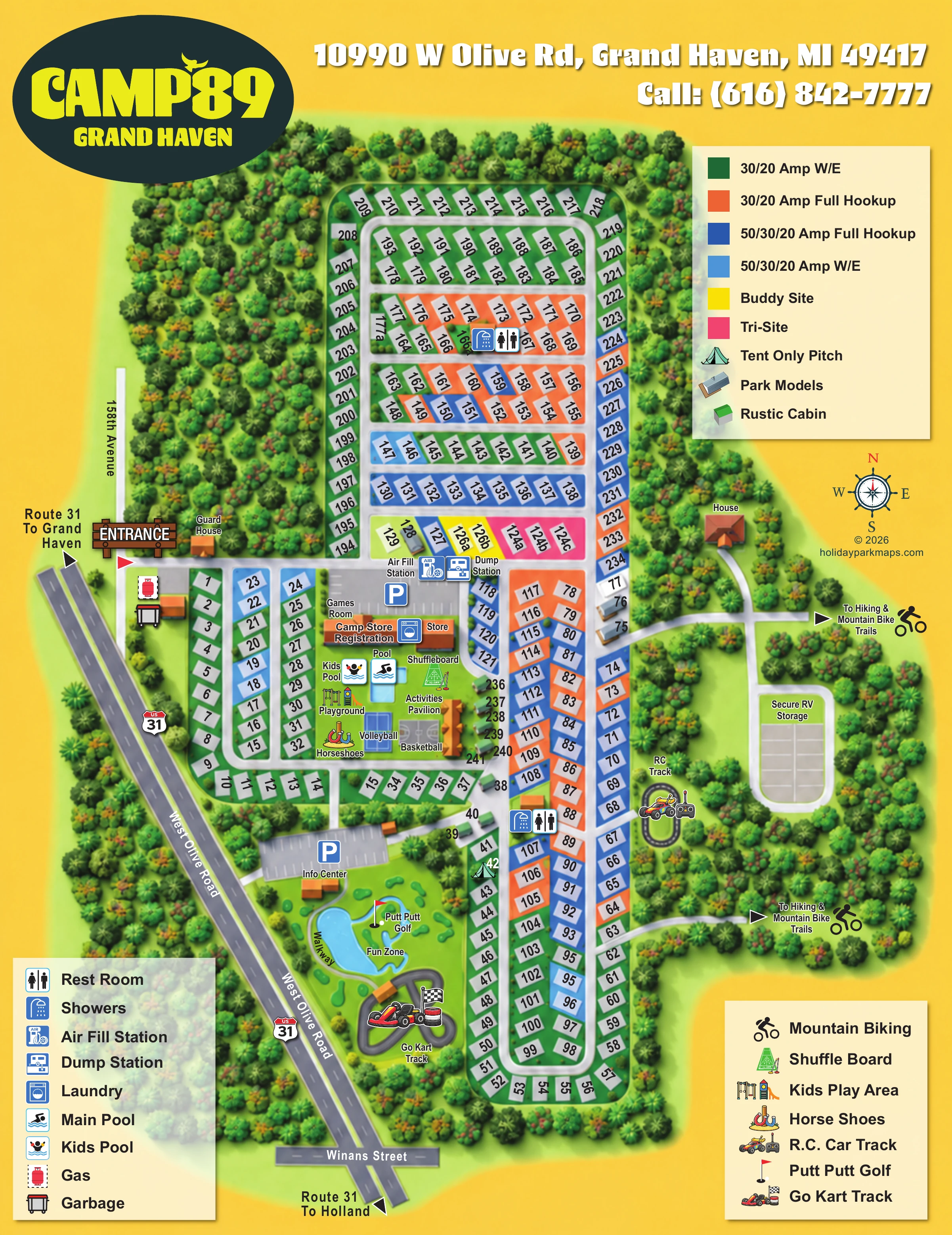
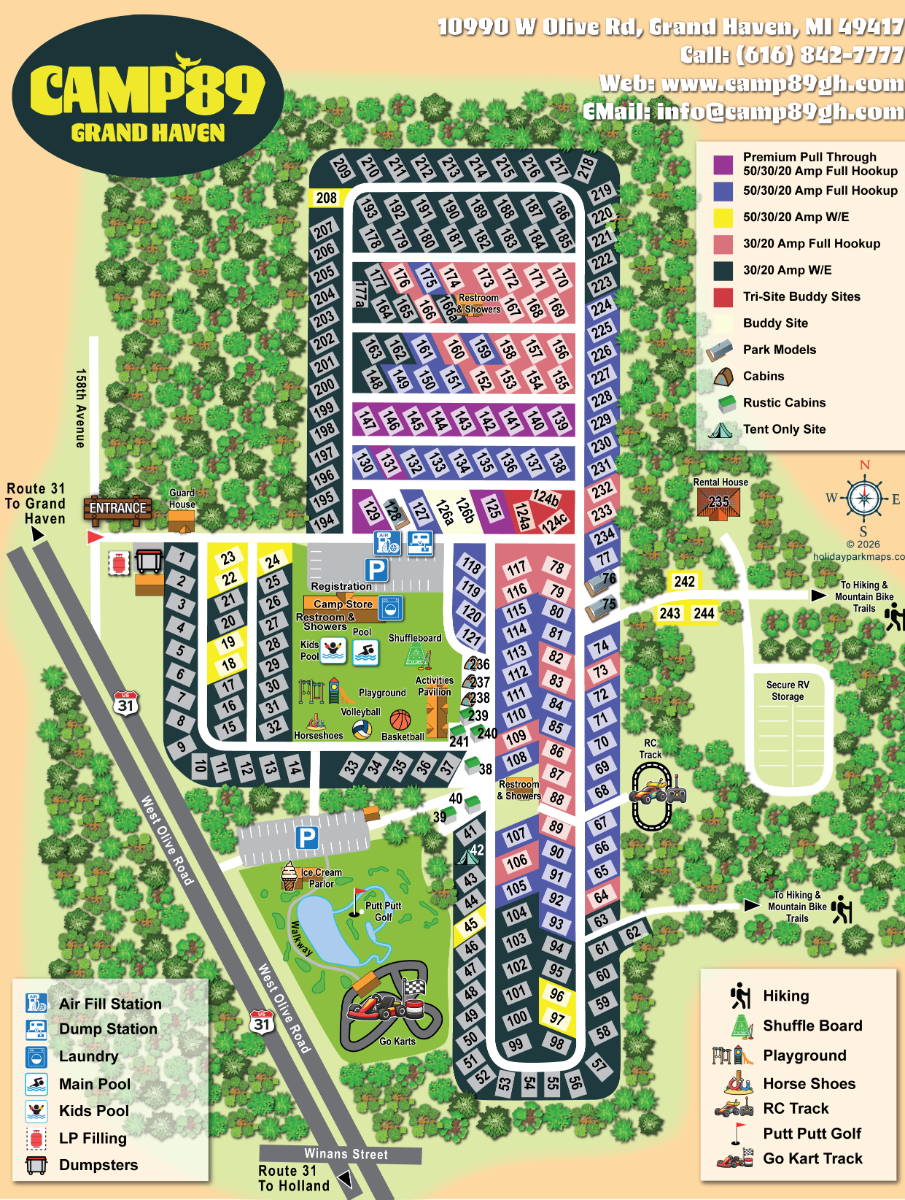
This illustrated map of Camp '89 Grand Haven presents a large RV campground in Grand Haven, Michigan, with a clear distinction between accommodation, practical services and family activities. A wooded border surrounds the numbered pitches, while a warm yellow page background and prominent CAMP89 branding give the sheet a recognisable identity.
The map brings together a northern grid of pitches, a central registration and recreation hub, and a long southern accommodation loop. Colour-coded areas explain different electrical and hookup options, with additional highlights for buddy sites and tri-sites. Small building illustrations identify park models and rustic cabins, and a tent symbol marks a tent-only pitch.
Activities are an important part of this particular design. Pools, a playground, sports courts and an activities pavilion sit close to the camp store, while miniature golf, a Fun Zone and a go-kart track occupy a separate southern leisure area. An RC car track, secure RV storage and arrows towards hiking and mountain-bike trails extend the map's coverage beyond the pitch rows. Three dedicated legend panels help visitors move between choosing a pitch, locating services and finding things to do.
The portrait plan uses an overhead road layout with pictorial buildings, trees and activity symbols. Arrival is clearly marked on the western edge by a timber-style entrance sign and a labelled guard house. The access road leads towards a grey parking area beside the camp store and registration buildings, where the map also places a games room, laundry, air fill station and dump station. Gas and rubbish symbols appear near the entrance.
Accommodation occupies two main shapes: a broad northern block with parallel internal rows and a narrow, elongated southern loop. Green, orange, dark blue and light blue distinguish water-and-electric and full-hookup pitches with different amperage options. Yellow buddy sites and pink tri-sites stand out near the central service area. Grey-roofed park models and green-roofed rustic cabins introduce a small amount of building-based accommodation among the pitch rows. Restroom and shower symbols appear in both the northern and southern sections.
The central green recreation space contains the main and children's pools, playground, shuffleboard, horseshoes, volleyball, basketball and a long activities pavilion. Farther south, an information centre and parking area lead into a separate leisure zone. Here the map shows Putt Putt golf, a blue water feature, a curving walkway, the Fun Zone and an illustrated go-kart circuit.
On the eastern side, white routes branch through the trees towards a house, an RC car track and a separately labelled secure RV storage area. Two arrows point towards hiking and mountain-bike trails. External road names, destination arrows and a compass rose supply wider orientation. The single artwork is supported by three cream legend panels; the enlarged views show overlapping portions of this same plan, not additional campground sections.
 Enlarge this map ↗
KEEP EXPLORING
Chosen for shared landscapes, accommodation or facilities.
 Explore the map ↗
Spain
Wooded campsite map with a river-crossing approach, curved touring rows, lodges and paired outdoor pools.
 Explore the map ↗
United States
Woodland RV campground map with mixed camping, three water landmarks and a central recreation hub.
 Explore the map ↗
United Kingdom
A wooded Allerton park plan with colour-coded neighbourhoods, touring pitches and a central facilities hub.
Features may come from the sample artwork, its key or published park information. Approximate numbers describe the drawing and may cover only part of a park. They are intended to help you compare map examples. Current facilities and booking information should be checked with the park.
TAKE A CLOSER LOOK
View the illustrated map in detail or choose a file to download. These are sample maps; contact the park for current visitor information.

LET’S MAP YOUR PARK
For a map quotation, find your park and draw a rough boundary around it. The area you select helps us work out the design time and price.
Draw your park for a quote ↗Or talk to our map designers
01751 473136