
Hedge-divided pitches and tree-lined boundaries
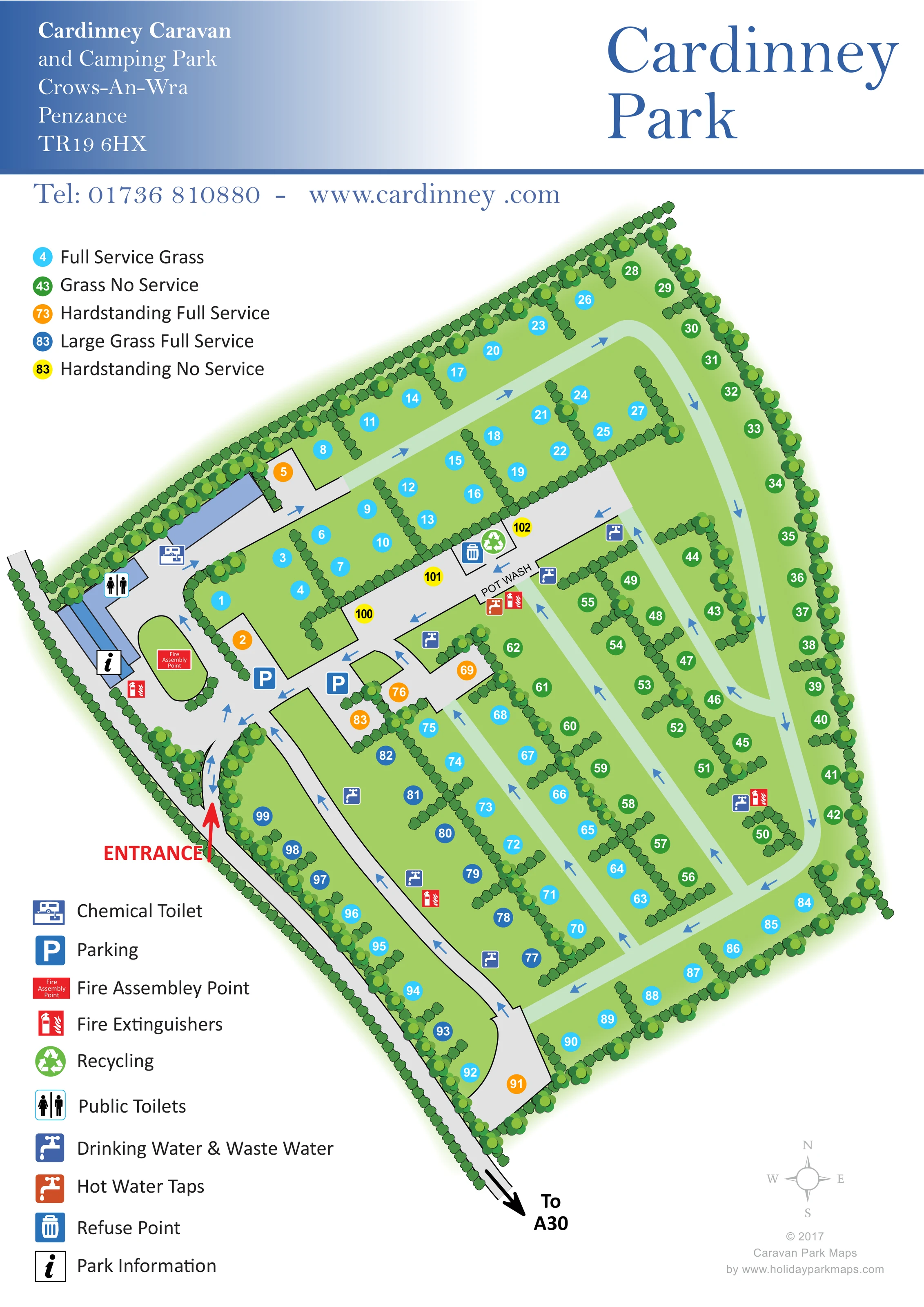
Continuous boundary planting encloses the site, while short hedge fingers and longer planted dividers organise individual pitches and rows.
ILLUSTRATED PARK MAP · P437
Cardinney Caravan, and Camping Park, Crows-An-Wra, Penzance · United Kingdom
 Enlarge the map ↗
A SENSE OF THE PLACE
Cardinney Caravan and Camping Park is an adults-only, family-run site in the Land's End peninsula. Open farmland surrounds landscaped pitches divided by trees, flowers and mature hedges.
Serviced and unserviced pitches provide a choice for touring and camping stays. The park's quieter approach suits visitors exploring western Cornwall, with dogs welcomed under the site's lead rules.
LOOK CLOSER
Continuous boundary planting encloses the site, while short hedge fingers and longer planted dividers organise individual pitches and rows.
The pitch key names full-service grass, grass without services, full-service hardstanding, large full-service grass and hardstanding without services; matching coloured markers appear throughout the plan.
An information symbol marks the building cluster immediately inside the entrance.
A toilet symbol appears on the blue building group beside the arrival area.
The chemical toilet symbol marks a location beside the upper part of the entrance-side building group.
Two parking symbols sit near the main internal junction beyond the entrance.
Repeated blue tap symbols mark shared water and waste water points beside pitch rows and circulation routes.
A labelled pot-wash location lies along the central service lane.
The pitch key names full-service grass, grass without services, full-service hardstanding, large full-service grass and hardstanding without services; matching coloured markers appear throughout the plan.
An information symbol marks the building cluster immediately inside the entrance.
A toilet symbol appears on the blue building group beside the arrival area.
The chemical toilet symbol marks a location beside the upper part of the entrance-side building group.
Two parking symbols sit near the main internal junction beyond the entrance.
Repeated blue tap symbols mark shared water and waste water points beside pitch rows and circulation routes.
A labelled pot-wash location lies along the central service lane.
An orange tap symbol marks hot water taps at the pot-wash location.
Adjacent refuse and recycling symbols identify a collection point on the central service lane.
Red extinguisher symbols are distributed around the site. A labelled fire assembly point occupies the rounded grass island near the information building.
Continuous boundary planting encloses the site, while short hedge fingers and longer planted dividers organise individual pitches and rows.
A large red arrow identifies the entrance on the left-hand side of the plan.
The approach road continues below the site to a black directional arrow labelled 'To A30'.
Grey access lanes and pale-green pitch routes form a connected perimeter circuit with internal branches; blue arrows indicate the depicted direction of travel.
READING THE MAP
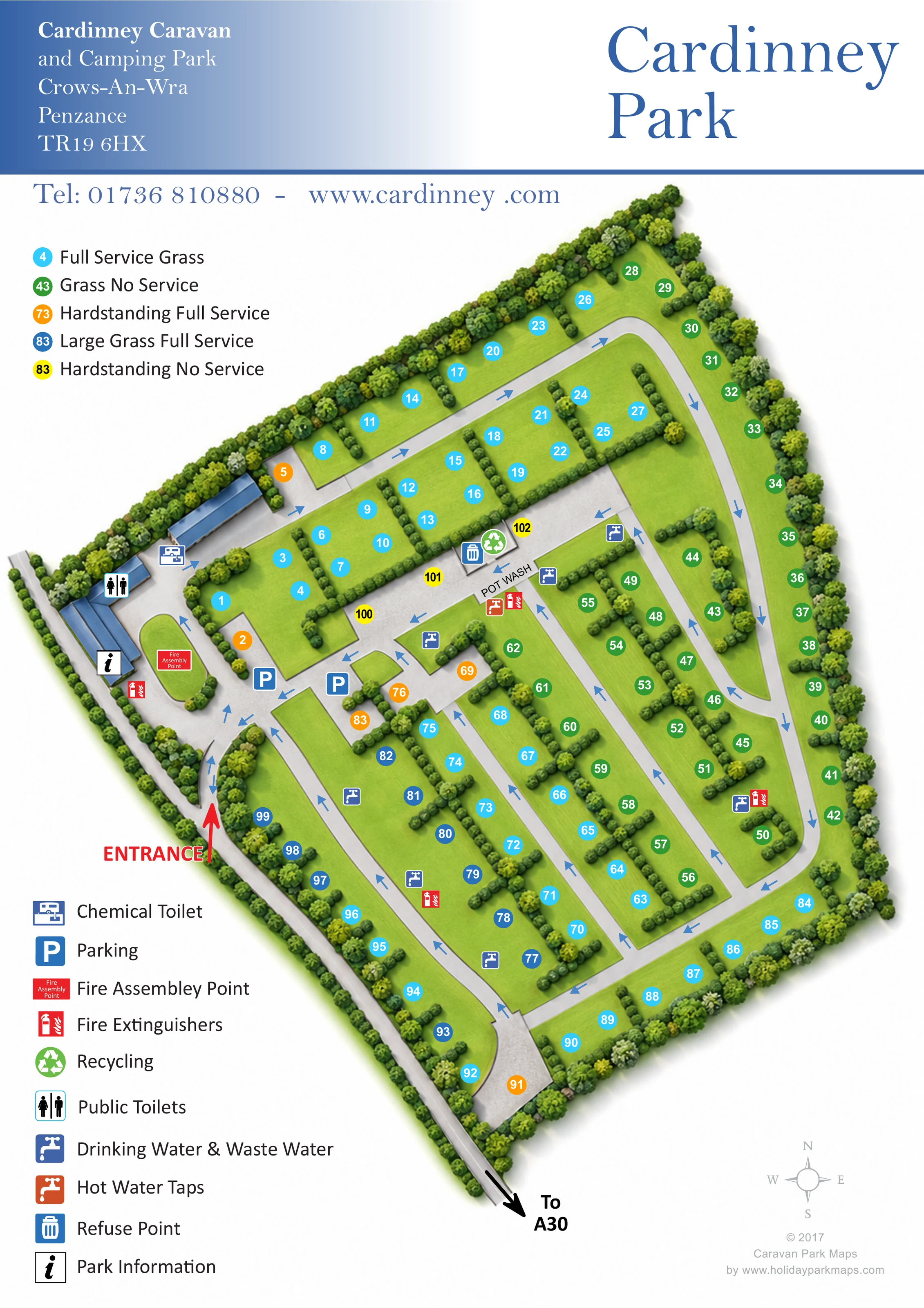
This map of Cardinney Caravan and Camping Park presents a landscaped touring and camping site at Crows-An-Wra, near Penzance in western Cornwall. Its distinctive feature is a five-colour pitch system that separates grass and hardstanding options by service level, with an additional category for larger serviced grass pitches. Numbered circles keep the accommodation layout readable without filling the plan with caravan or tent illustrations.
The site stretches diagonally across a portrait page, enclosed by illustrated hedges and trees. Short planted dividers show how the pitches are arranged within longer rows, while blue arrows trace the internal circulation. A prominent red entrance marker leads visitors towards the information building, toilets, parking and fire assembly point. Further into the site, the map identifies pot washing, water points, chemical toilet disposal, refuse and recycling.
The blue serif heading and gradient address panel give the sheet a traditional park identity, while the two separate legends handle practical detail. It is a useful example for touring and camping parks that need to explain varied pitch specifications alongside an organised network of shared facilities.
The artwork comprises one portrait site plan, with the park name and address across the top and the illustrated enclosure running diagonally from upper right towards lower left. A road beside the lower-left boundary connects to the arrow labelled 'To A30'. The red entrance arrow directs attention to the arrival area, where blue building footprints carry information, public toilet and chemical toilet symbols. A rounded grass island contains the fire assembly point, and parking is marked at the nearby internal junction.
Beyond this cluster, a grey service lane crosses the site. It includes several hardstanding bays, a refuse and recycling point, and the labelled pot-wash location with an orange hot-water tap symbol. Blue drinking water and waste water symbols recur beside the accommodation rows, accompanied in several places by red fire extinguisher markers.
The majority of the pitches sit on a continuous light-green ground. Short hedge fingers divide neighbouring spaces, while longer planted lines separate rows. Larger tree symbols reinforce the outer boundary and selected internal junctions. Pale-green routes form a perimeter circuit and parallel internal connections, with blue arrows making the depicted circulation easy to follow.
The upper-left legend distinguishes full-service grass, unserviced grass, full-service hardstanding, large full-service grass and unserviced hardstanding through cyan, green, orange, blue and yellow numbered circles. A second legend below explains the facility pictograms. A small compass occupies the lower-right white margin. The plan relies on clear surface shapes, planting and numbered markers rather than perspective buildings or illustrated vehicles, keeping its emphasis on pitch choice and everyday navigation.
 Enlarge this map ↗
KEEP EXPLORING
Chosen for shared landscapes, accommodation or facilities.
 Explore the map ↗
United Kingdom
Colour-coded campsite map with riverside pitches, bell tents, a swimming pool and fishing lake.
 Explore the map ↗
United Kingdom
Coastal park map with static-caravan rows, touring pitches, a camping field and two leisure clusters.
 Explore the map ↗
United Kingdom
A wooded Allerton park plan with colour-coded neighbourhoods, touring pitches and a central facilities hub.
Features may come from the sample artwork, its key or published park information. Approximate numbers describe the drawing and may cover only part of a park. They are intended to help you compare map examples. Current facilities and booking information should be checked with the park.
TAKE A CLOSER LOOK
View the illustrated map in detail or choose a file to download. These are sample maps; contact the park for current visitor information.


LET’S MAP YOUR PARK
For a map quotation, find your park and draw a rough boundary around it. The area you select helps us work out the design time and price.
Draw your park for a quote ↗Or talk to our map designers
01751 473136