
Dog Walking Field
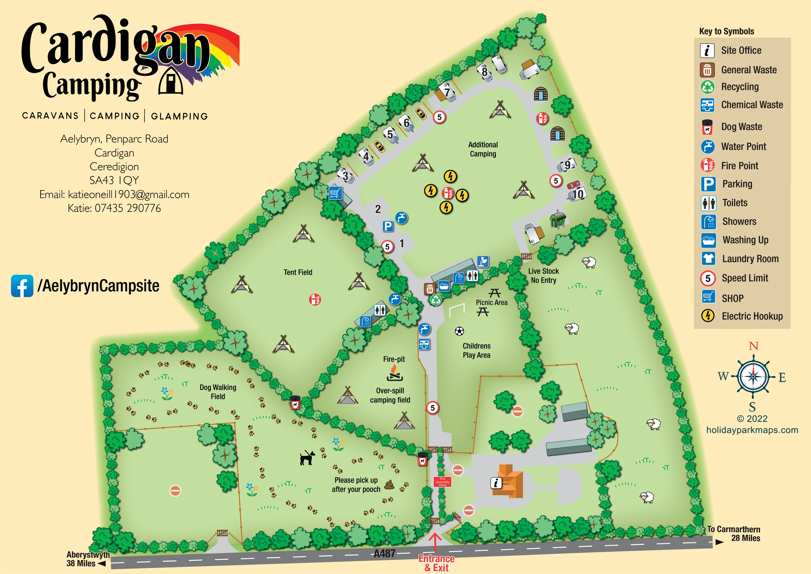
A substantial western field is labelled for dog walking, with paw-print trails, a dog illustration and a dog-clean-up reminder.
ILLUSTRATED PARK MAP · P436
Aelybryn, Penparc Road, Cardigan, Ceredigion · United Kingdom
 Enlarge the map ↗
A SENSE OF THE PLACE
Cardigan Camping and Caravan Site is based at Aelybryn, Penparc Road, Cardigan, Ceredigion. The matched directory describes a farm campsite off the A487 on the Penparc side of Cardigan. UKCampsite lists touring caravans, motorhomes and small campervans at the matching address.
The directory describes electric hook-ups, water points, chemical disposal, toilets, showers and washing-up provision.
LOOK CLOSER
A substantial western field is labelled for dog walking, with paw-print trails, a dog illustration and a dog-clean-up reminder.
The long eastern field contains sheep illustrations and is labelled 'Live Stock No Entry'.
Dense green hedges and varied tree symbols define the perimeter and divide camping, recreation, dog-walking and livestock areas.
An information symbol marks the orange-roofed building beside the entrance drive.
A shopping-trolley symbol marks a small building on the western side of the northern accommodation loop.
Toilet and shower symbols identify facilities beside the Tent Field and at the southern edge of the northern accommodation area.
A washing-up symbol is grouped with the central service building's toilet and shower symbols.
Blue tap symbols mark water points around the touring area, Tent Field facilities and central approach.
An information symbol marks the orange-roofed building beside the entrance drive.
A shopping-trolley symbol marks a small building on the western side of the northern accommodation loop.
Toilet and shower symbols identify facilities beside the Tent Field and at the southern edge of the northern accommodation area.
A washing-up symbol is grouped with the central service building's toilet and shower symbols.
A laundry-room symbol appears in the key; a corresponding position is not clearly identifiable on the plan.
Blue tap symbols mark water points around the touring area, Tent Field facilities and central approach.
Chemical-waste symbols appear near the central service building and beside the approach through the camping areas.
General-waste and recycling symbols are grouped by the central facilities.
Dog-waste symbols are placed along the dog-walking field boundary and near the entrance-side gate.
Yellow lightning symbols form a cluster within the Additional Camping area.
A blue parking symbol sits on the western approach to the northern accommodation loop.
A labelled picnic area with table illustrations lies beside the central facilities and children's play space.
A labelled grass area beside the main drive is illustrated with a football and goal.
A labelled flame illustration marks a fire-pit in the overflow camping area.
Red extinguisher symbols appear in the Tent Field and northern camping and accommodation area.
A red labelled marker identifies the assembly point near the entrance-side office area.
A substantial western field is labelled for dog walking, with paw-print trails, a dog illustration and a dog-clean-up reminder.
The long eastern field contains sheep illustrations and is labelled 'Live Stock No Entry'.
Dense green hedges and varied tree symbols define the perimeter and divide camping, recreation, dog-walking and livestock areas.
A red entrance-and-exit arrow connects the southern boundary road to the central drive. Road-end labels point towards Aberystwyth and Carmarthen.
A grey access spine passes the office and shared facilities before joining a loop around the northern accommodation and Additional Camping area.
Repeated red-ringed '5' speed symbols, illustrated gates and no-entry symbols differentiate circulation routes from restricted farm and building areas.
READING THE MAP
This illustrated map of Cardigan Camping places a small touring and glamping area within a clearly defined farm-campsite setting in Cardigan, Ceredigion. An entrance from the A487 leads through the site towards a northern accommodation loop, while hedges and trees separate the camping fields, recreation space and livestock enclosure. The result is a map built around recognisable places rather than an undifferentiated spread of pitches.
The artwork distinguishes a Tent Field, Additional Camping and an Over-spill camping field, alongside caravan-style accommodation, timber pods and a wagon illustration. Shared facilities are marked with bold service symbols, and a large key explains everything from water points and chemical waste to the shop and electric hook-up. A dog-walking field, picnic area, children's play area and fire-pit give the plan its particular character.
Warm cream margins, pale green fields and a rainbow-accented Cardigan Camping identity frame the practical information. This sample is especially relevant to rural campsites that need to explain mixed accommodation, shared amenities and the relationship between visitor areas and working farmland.
The plan is arranged around a grey access route entering from the A487 along the bottom of the page. A red entrance-and-exit arrow marks the arrival point, with the site office shown nearby as an orange-roofed building carrying an information symbol. Further along the drive, the map places overflow camping to the west and a children's play area and picnic space to the east. The fire-pit is labelled within the overflow field.
At the northern end, the route opens into a loop lined with caravan-style accommodation and numbered positions. The grassy centre is labelled Additional Camping and contains tent illustrations and a cluster of electric hook-up symbols. Two rounded timber pods and a green wagon-style unit add a distinct glamping vocabulary on the eastern side. A shop symbol marks a small building on the opposite side of the loop.
The separate Tent Field occupies the western middle of the plan. Toilet and shower symbols appear beside it, while another service building near the loop is accompanied by washing-up, toilet and shower markers. Water, chemical-waste, general-waste and recycling symbols identify supporting facilities. The laundry room is included in the key, although its position is not clearly marked on the plan.
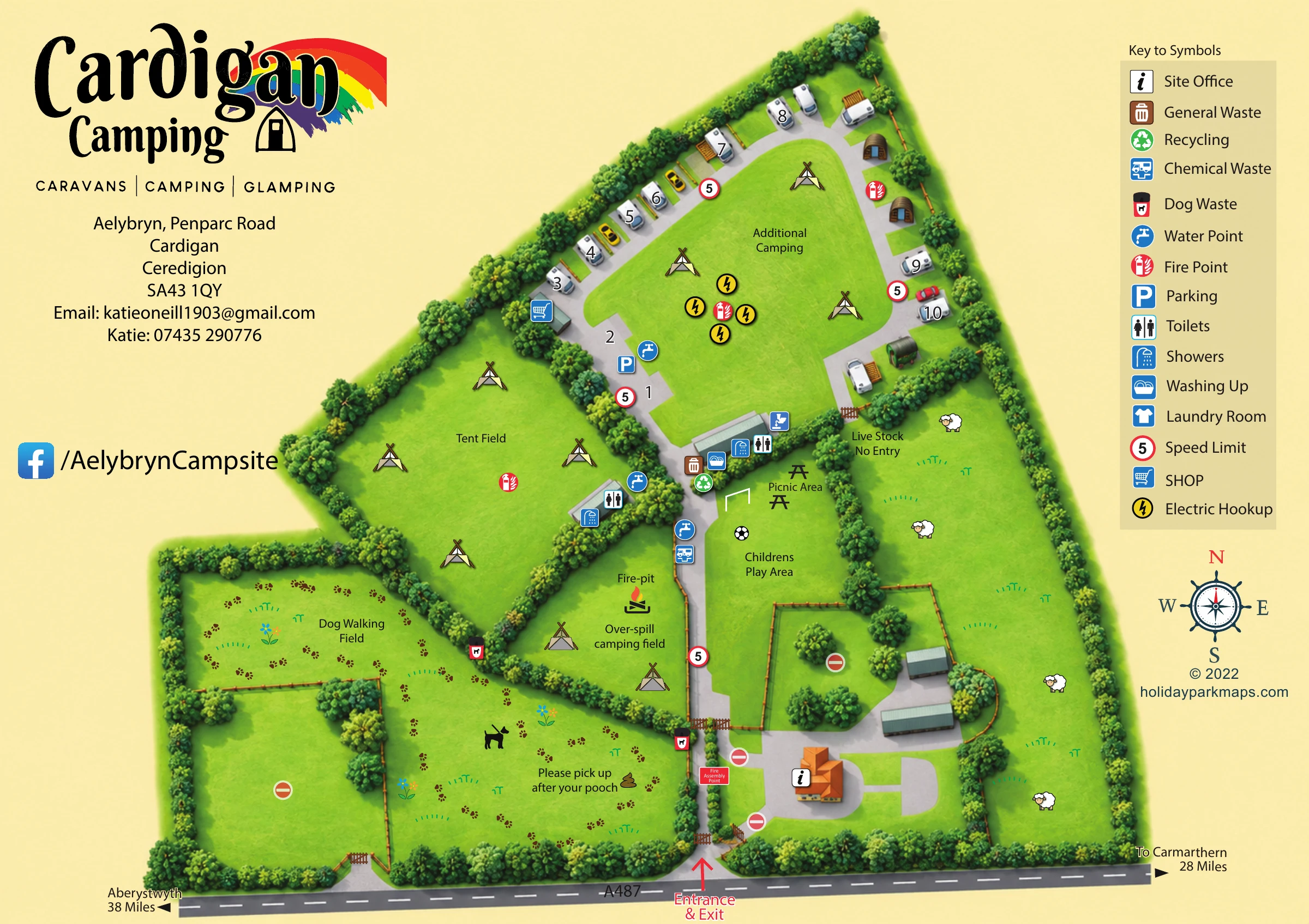
A broad dog-walking field fills much of the lower-left area, using paw prints and a dog illustration to reinforce its purpose. On the right, sheep and a 'Live Stock No Entry' label distinguish the farm enclosure. Hedges, gates and repeated speed symbols organise the transitions between these spaces. The single landscape-format artwork is supported by an enlarged view of its key and eastern accommodation area; this is a detail of the same map, not a separate site section.
 Enlarge this map ↗
KEEP EXPLORING
Chosen for shared landscapes, accommodation or facilities.
 Explore the map ↗
United Kingdom
Mixed-accommodation park map with woodland, public footpaths and clearly differentiated service symbols.
 Explore the map ↗
United Kingdom
Illustrated touring, camping and glamping map with landscaped pitch groups, a central amenity hub and separate entrance and exit.
 Explore the map ↗
United Kingdom
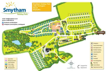
Colour-coded accommodation, woodland ponds and a Tarka Trail footpath on Smytham’s illustrated park map.
Features may come from the sample artwork, its key or published park information. Approximate numbers describe the drawing and may cover only part of a park. They are intended to help you compare map examples. Current facilities and booking information should be checked with the park.
LET’S MAP YOUR PARK
For a map quotation, find your park and draw a rough boundary around it. The area you select helps us work out the design time and price.
Draw your park for a quote ↗Or talk to our map designers
01751 473136