
Tree belts and grass banking
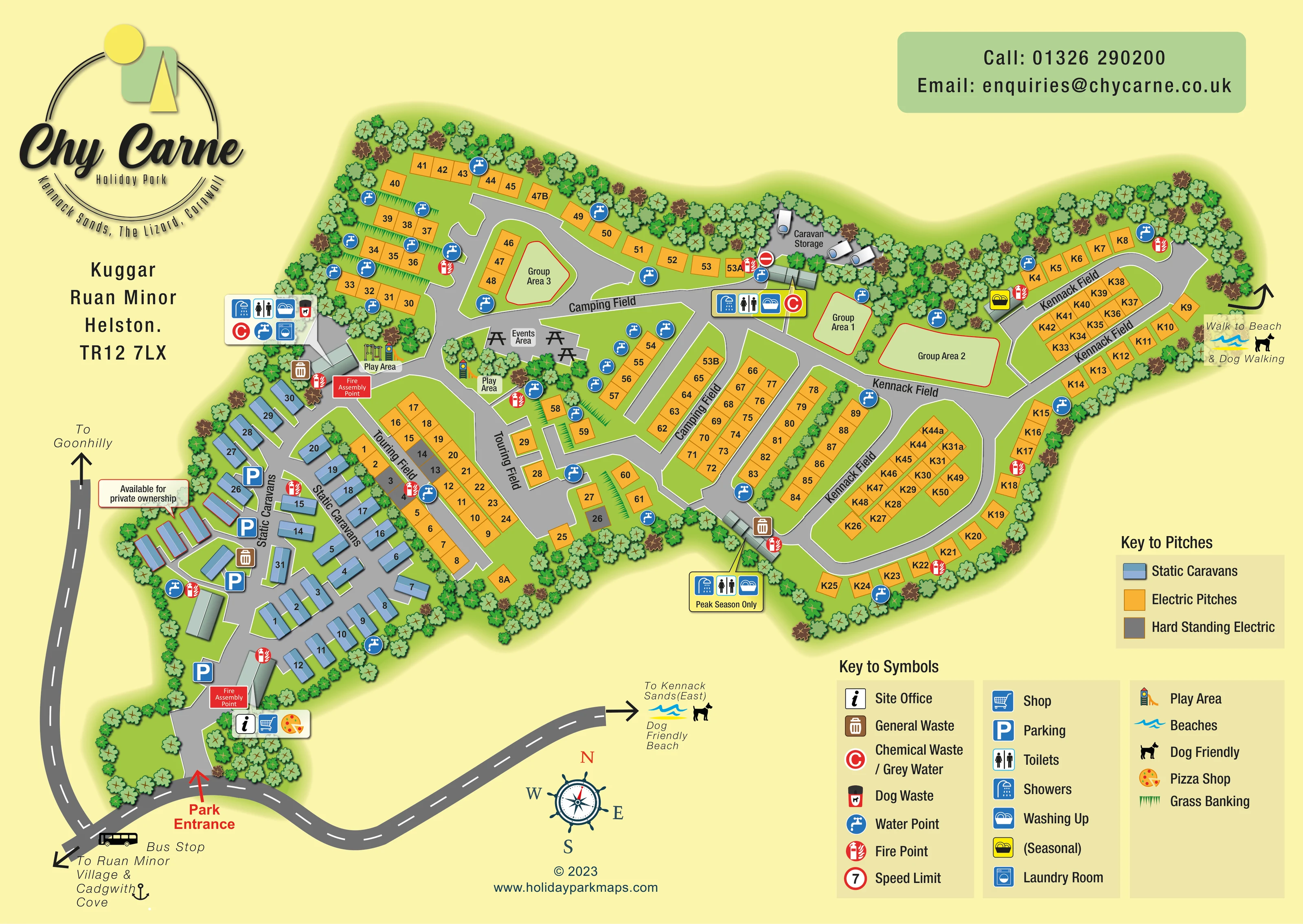
Dense stylised tree belts frame the park and separate sections. Short green banking marks divide several pitch rows.
ILLUSTRATED PARK MAP · P078
Kuggar, Ruan Minor, Helston · United Kingdom
 Enlarge the map ↗
A SENSE OF THE PLACE
Chy Carne is a family-owned holiday park near Kennack Sands on Cornwall's Lizard Peninsula. It offers holiday caravans, touring and camping pitches, and holiday home ownership.
The beach is within walking distance, making the coast a central part of a stay. On-site toilets and showers support campers, and the map provides an overview of the different accommodation areas and routes around the park.
LOOK CLOSER
Dense stylised tree belts frame the park and separate sections. Short green banking marks divide several pitch rows.
An information symbol marks the office beside the entrance, grouped with the shop and pizza shop.
A shopping-trolley symbol identifies the shop at the entrance-side service cluster.
A distinctive pizza illustration marks a pizza shop beside the office and shop.
Grouped service symbols appear near the western Camping Field, at the central field junction and beside the lower Kennack Field. The latter block is labelled Peak Season Only.
A yellow washing-up symbol appears beside the upper Kennack Field road; the key identifies this variant as seasonal.
A washing-machine symbol is included in the western service cluster.
Two illustrated play areas sit near the junction between static caravans, Touring Field and Camping Field.
An information symbol marks the office beside the entrance, grouped with the shop and pizza shop.
A shopping-trolley symbol identifies the shop at the entrance-side service cluster.
A distinctive pizza illustration marks a pizza shop beside the office and shop.
Grouped service symbols appear near the western Camping Field, at the central field junction and beside the lower Kennack Field. The latter block is labelled Peak Season Only.
A yellow washing-up symbol appears beside the upper Kennack Field road; the key identifies this variant as seasonal.
A washing-machine symbol is included in the western service cluster.
Two illustrated play areas sit near the junction between static caravans, Touring Field and Camping Field.
A labelled communal area with picnic-table illustrations occupies a central space beside Camping Field.
Three pale-green spaces with red outlines are distributed between Camping Field and upper Kennack Field.
A small tree-framed storage area containing caravan illustrations lies along the upper central boundary.
Blue parking signs are concentrated around the static-caravan section and entrance approach.
Repeated blue tap symbols are distributed throughout the accommodation fields.
Brown general-waste symbols occur beside internal routes, while a dog-waste symbol appears in the western service cluster.
Red C symbols identify disposal facilities at the western and central service clusters.
Red fire-point symbols are spread across the fields. Two red Fire Assembly Point panels appear in the western section, including one near the entrance.
The legend includes a red-ringed speed-limit symbol containing 7; no specific on-plan location is established.
Dense stylised tree belts frame the park and separate sections. Short green banking marks divide several pitch rows.
A red arrow identifies arrival from the road along the lower edge. Branching grey internal roads connect the caravan section to the looping pitch fields.
A bus illustration and label mark a stop on the external road near the entrance.
An arrow at the eastern end of Kennack Field is labelled Walk to Beach & Dog Walking.
The lower external road points towards Kennack Sands (East), with wave and dog symbols and the text Dog Friendly Beach. The beach itself is outside the park plan.
External-road arrows point towards Goonhilly and towards Ruan Minor Village and Cadgwith Cove.
READING THE MAP
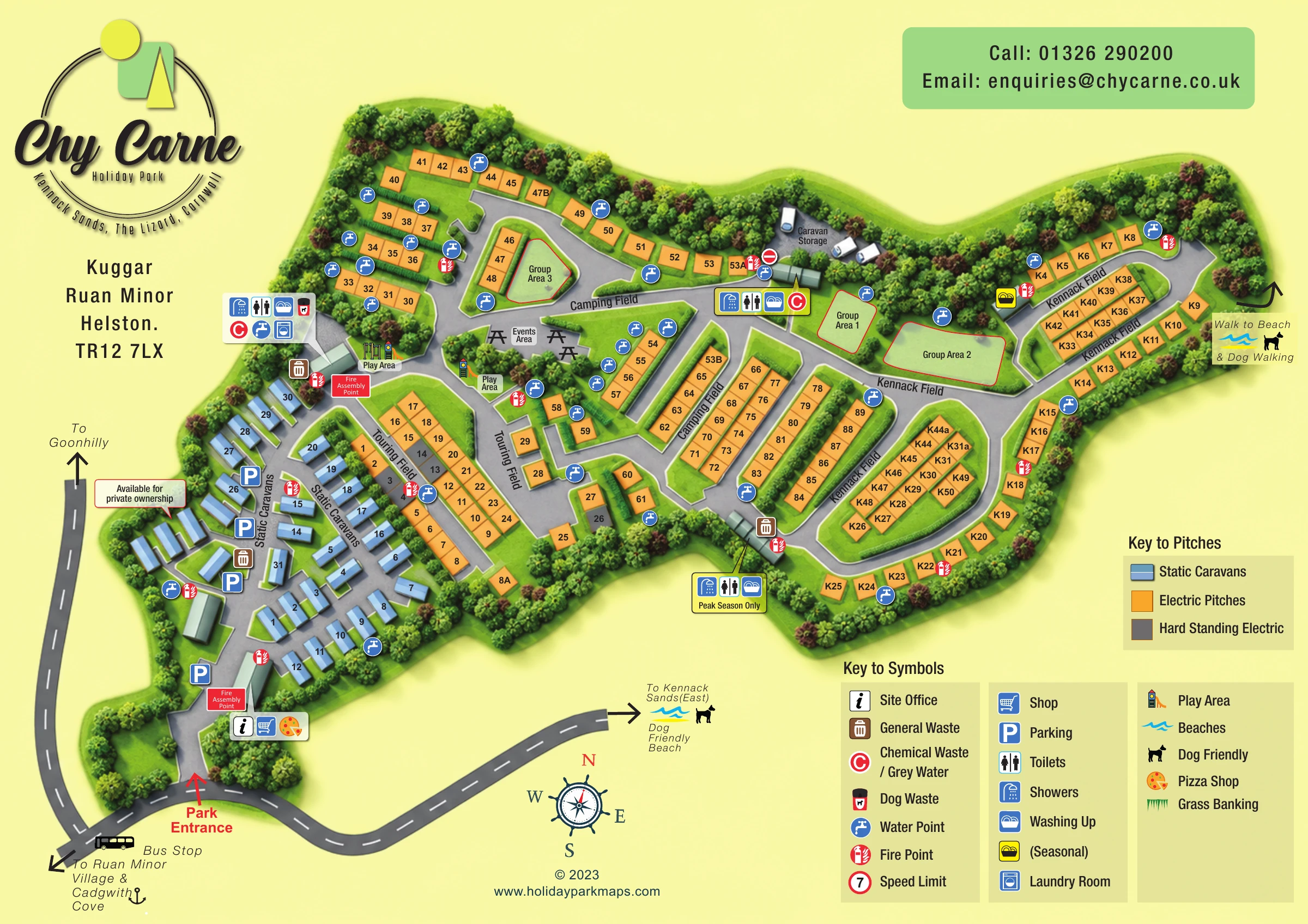
This illustrated map of Chy Carne Holiday Park brings together a varied caravan, touring and camping layout near Kennack Sands on Cornwall’s Lizard Peninsula. The plan distinguishes the blue static-caravan area from orange electric pitches and grey hard-standing electric pitches, making the accommodation pattern readable before visitors look for an individual pitch.
The park stretches from an entrance-side cluster of caravans into the Touring, Camping and Kennack fields. Curving roads, tree belts and clearly named sections explain how these areas connect, while grouped symbols highlight the office, shop, pizza shop and washing facilities. Play areas, an events space and three group areas add useful landmarks within the larger pitch layout.
The coastal setting is conveyed through directions rather than a decorative seascape: arrows point towards Kennack Sands, a beach and dog-walking route, and nearby villages. A bus stop is also shown beside the approach road. Pale yellow, fresh greens and a nautical compass give the page its character, while separate accommodation and facility keys keep the practical information organised.
The single-page artwork presents the park as an elongated, tree-framed plan, with the entrance at the lower-left side and Kennack Field extending towards the right. The external approach road is darker than the internal routes and carries directional arrows towards Goonhilly, Ruan Minor Village, Cadgwith Cove and Kennack Sands East. A bus-stop illustration sits close to the entrance, while a separate arrow at the far eastern end identifies the walk to the beach and dog-walking route.
Inside the park, blue static caravans follow short lanes and curved rows in the western section. Parking symbols punctuate this area, and a callout identifies a small group available for private ownership. Orange electric pitches dominate the central and eastern fields, with grey parcels identifying hard-standing electric pitches. Pitch labels are placed directly within the coloured shapes, and field names follow the roads between them.
The entrance service panel combines the site office, shop and pizza shop. Further panels bring together toilets, showers and washing-up facilities; the western cluster also includes laundry and disposal symbols. A lower Kennack Field block is marked Peak Season Only, and a yellow seasonal washing-up marker appears in the upper eastern section. Water, fire and waste symbols recur along the routes rather than being confined to one service area.
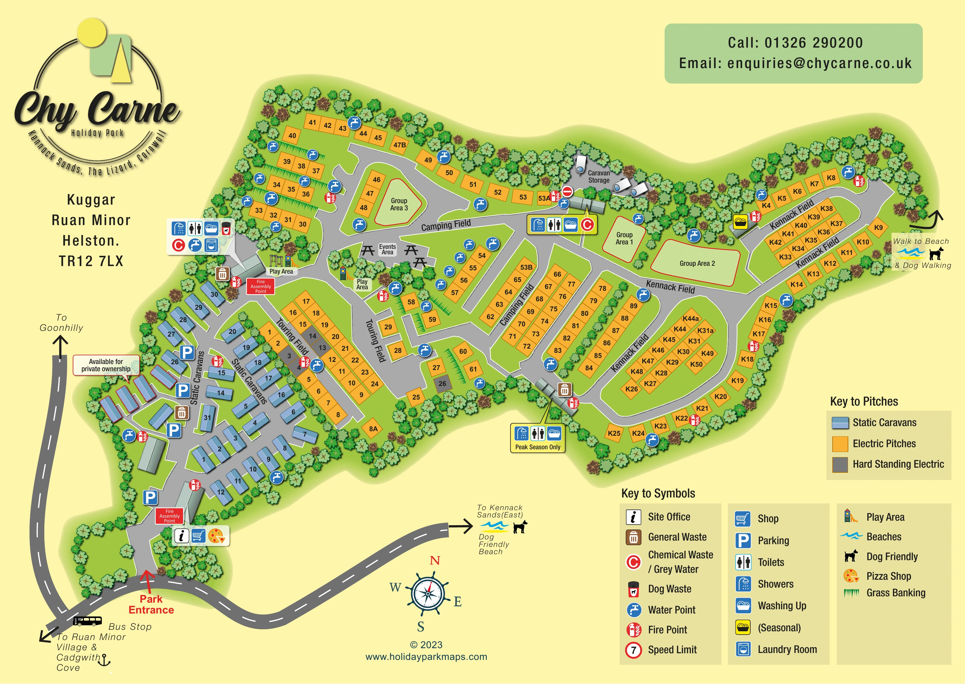
Two illustrated play areas and an events area with picnic tables provide central landmarks. Three red-outlined group spaces and a small caravan-storage area are also named. Dense tree crowns and grass-banking strokes articulate boundaries and pitch rows. The lower-right legends explain both accommodation colours and amenity symbols, balancing the large logo, address and contact panel elsewhere on the page. The accompanying detail views enlarge parts of this same composition rather than presenting additional park sections.
 Enlarge this map ↗
KEEP EXPLORING
Chosen for shared landscapes, accommodation or facilities.
 Explore the map ↗
United Kingdom
Coastal park map with static-caravan rows, touring pitches, a camping field and two leisure clusters.
 Explore the map ↗
United Kingdom
Coastal park plan with colour-coded pitches, named neighbourhoods and a Morecambe Bay walking route.
 Explore the map ↗
United Kingdom
A colour-zoned coastal park map with touring areas, woodland trails, ponds and a leisure club.
Features may come from the sample artwork, its key or published park information. Approximate numbers describe the drawing and may cover only part of a park. They are intended to help you compare map examples. Current facilities and booking information should be checked with the park.
TAKE A CLOSER LOOK
View the illustrated map in detail or choose a file to download. These are sample maps; contact the park for current visitor information.


LET’S MAP YOUR PARK
For a map quotation, find your park and draw a rough boundary around it. The area you select helps us work out the design time and price.
Draw your park for a quote ↗Or talk to our map designers
01751 473136
 chycarnegbmapsa_large.png