
The Quiet Area
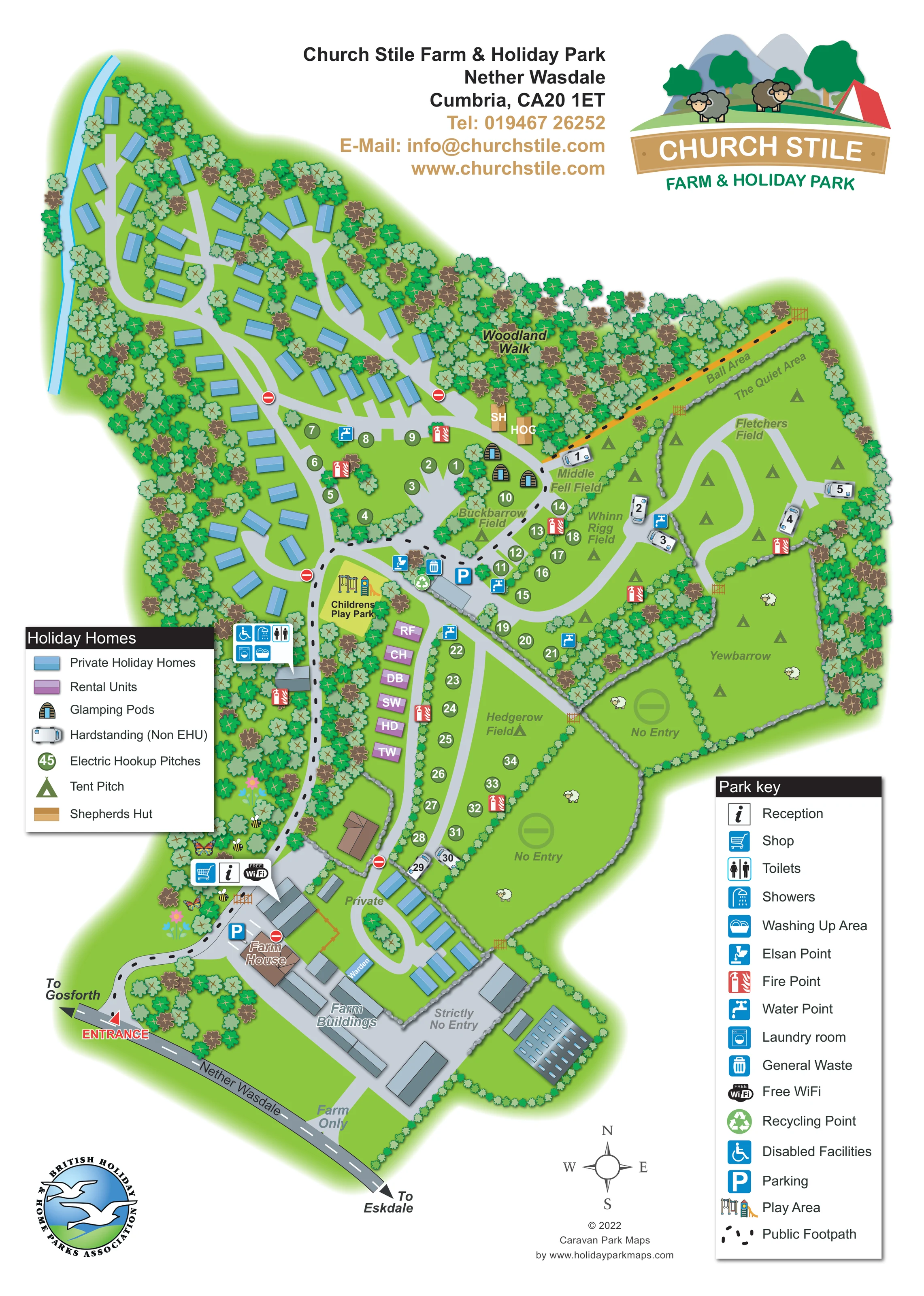
A named strip beside the ball area and above Fletchers Field provides a distinct wayfinding reference.
ILLUSTRATED PARK MAP · P445
Church Stile Farm & Holiday Park, Nether Wasdale, Cumbria · United Kingdom
 Enlarge the map ↗
A SENSE OF THE PLACE
Church Stile Farm and Holiday Park sits in oak woodland at Nether Wasdale, with views towards the Wasdale fells. The traditional sheep-farm setting accommodates campers, touring vehicles, shepherd's huts and holiday caravans.
Electric and hardstanding options are available, with washrooms serving the campsite. A children's play area and space for ball games provide recreation on site, while the valley offers a base for exploring the Lake District.
LOOK CLOSER
A named strip beside the ball area and above Fletchers Field provides a distinct wayfinding reference.
Dense, individually drawn trees surround the park, divide accommodation groups and fill a substantial woodland belt across the upper centre.
Buckbarrow, Middle Fell Field, Whinn Rigg Field, Fletchers Field, Yewbarrow and Hedgerow Field structure the camping side of the map.
Grey stone-wall lines, green hedges and small timber gates separate the grass fields and farm enclosures.
A narrow blue watercourse follows the western edge of the upper holiday-home area.
The southern portion contains a labelled farmhouse, farm buildings, a warden building and working-farm areas distinguished from visitor accommodation.
Reception and shop symbols are grouped beside the buildings reached shortly after entering from the Nether Wasdale road.
A service-symbol cluster beside the children's play park identifies toilets, showers, washing-up provision and a laundry room.
Reception and shop symbols are grouped beside the buildings reached shortly after entering from the Nether Wasdale road.
A service-symbol cluster beside the children's play park identifies toilets, showers, washing-up provision and a laundry room.
A wheelchair symbol marks facilities within the washroom-service cluster; the artwork does not describe their specifications.
An Elsan disposal symbol appears beside the central service and parking area.
Repeated blue tap symbols and red fire-point symbols are distributed through the accommodation and camping areas.
Waste and recycling symbols are grouped at the central service area.
A free-WiFi symbol is displayed beside reception and the shop; no coverage boundary is shown.
Parking symbols identify spaces near the arrival buildings and central camping services.
A labelled playground with illustrated swings and a slide occupies a yellow-green enclosure near the centre-left of the plan.
A long, narrow recreation strip is labelled along the north-eastern woodland boundary.
A named strip beside the ball area and above Fletchers Field provides a distinct wayfinding reference.
Dense, individually drawn trees surround the park, divide accommodation groups and fill a substantial woodland belt across the upper centre.
The central woodland is labelled Woodland Walk, although a separate continuous walking circuit is not clearly delineated there.
A black dotted route runs from the arrival area through the site towards the north-eastern boundary.
Buckbarrow, Middle Fell Field, Whinn Rigg Field, Fletchers Field, Yewbarrow and Hedgerow Field structure the camping side of the map.
Grey stone-wall lines, green hedges and small timber gates separate the grass fields and farm enclosures.
A narrow blue watercourse follows the western edge of the upper holiday-home area.
The southern portion contains a labelled farmhouse, farm buildings, a warden building and working-farm areas distinguished from visitor accommodation.
The entrance is highlighted on the southern road, with directional labels towards Gosforth and Eskdale.
Private, No Entry, Strictly No Entry and Farm Only labels distinguish farm access and restricted enclosures from guest routes.
READING THE MAP
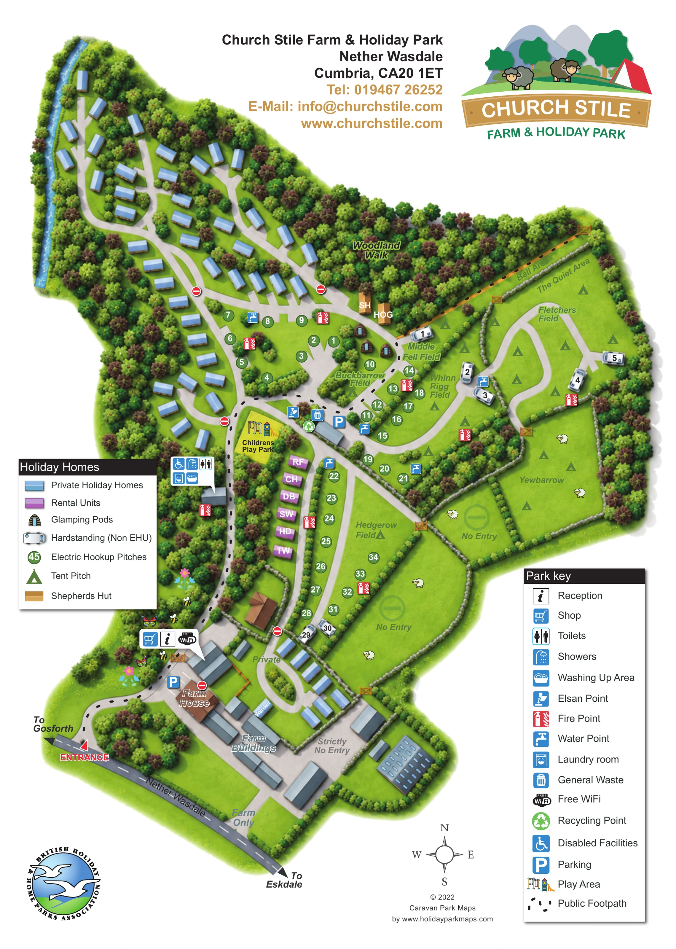
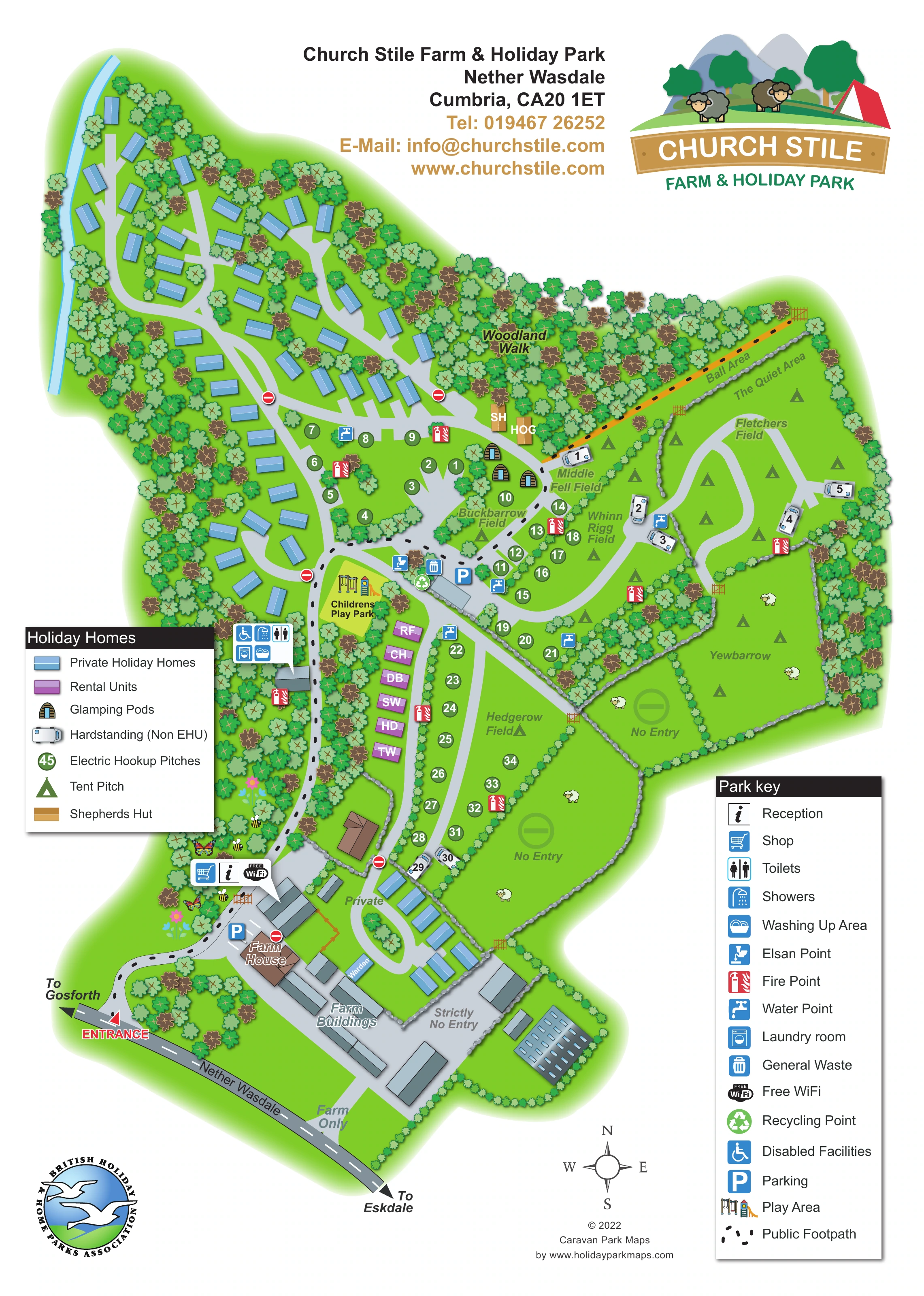
This illustrated map of Church Stile Farm & Holiday Park brings together a wooded holiday-home area, open camping fields and a working-farm setting at Nether Wasdale in Cumbria. Its portrait layout follows the site's irregular shape, from the road entrance and farm buildings in the south to tree-lined accommodation loops in the north-west and grass fields across the eastern side.
Colour makes the accommodation mix easy to distinguish: blue private holiday homes, purple rental units, small glamping pods and shepherds huts sit alongside numbered electric pitches and touring hardstandings. Named fields, including Buckbarrow, Whinn Rigg and Yewbarrow, give the camping areas a recognisable local character without implying a fixed capacity for open tent spaces.
The map also gives practical prominence to reception, the shop, washroom services, parking and the children's play park. Woodland, stone walls, hedges and sheep illustrations retain the site's rural identity, while two clear keys explain the accommodation and facility symbols. It is a useful example of mapping a mixed holiday park where guest routes and farm areas need to remain visually distinct.
Arrival is shown from the Nether Wasdale road at the lower-left edge, with directions towards Gosforth and Eskdale. The access lane curves past reception, the shop and parking before leading into the visitor areas. Labelled farm buildings and the farmhouse occupy the southern part of the plan, where private and restricted-access markings distinguish the working farm from guest circulation.
The north-western sector contains blue private holiday homes arranged along branching, tree-lined drives. A narrow blue watercourse follows its western boundary. Further south, a smaller holiday-home group sits near the farm, while purple rental units form a short row beside the central lane. Illustrated pods and tan shepherds-hut symbols occupy the transition between woodland and camping fields.
Across the centre and east, pale-grey lanes connect named grass areas enclosed by hedges and stone walls. Green numbered circles identify electric-hookup pitches, small touring-vehicle drawings mark non-electric hardstandings, and triangular tent symbols indicate camping areas. Fletchers Field lies below the long ball-area strip and The Quiet Area; Yewbarrow and Hedgerow occupy larger fields further south.
The children's play park is drawn beside the central washroom facilities. Nearby symbols identify showers, toilets, washing-up provision, laundry and disabled facilities. Water and fire points recur around the site, with waste, recycling, Elsan disposal and parking grouped at useful service locations. A black dotted public footpath is distinguished from the vehicle lanes, and the upper woodland is labelled Woodland Walk.
Two boxed legends explain the visual system. The enlarged detail view repeats part of the same artwork, making the service key and southern field boundaries easier to read rather than introducing another site section.
 Enlarge this map ↗
KEEP EXPLORING
Chosen for shared landscapes, accommodation or facilities.
 Explore the map ↗
United Kingdom
Illustrated caravan park plan with woodland and riverside walks, fishing pools and wildlife panels.
 Explore the map ↗
United Kingdom
Woodland park map with mixed pitches, bell tents, lodges and a fishing lake.
 Explore the map ↗
United Kingdom
Illustrated farm campsite map with touring pitches, pods, camping fields and a riverside dog-walk route.
Features may come from the sample artwork, its key or published park information. Approximate numbers describe the drawing and may cover only part of a park. They are intended to help you compare map examples. Current facilities and booking information should be checked with the park.
TAKE A CLOSER LOOK
View the illustrated map in detail or choose a file to download. These are sample maps; contact the park for current visitor information.



LET’S MAP YOUR PARK
For a map quotation, find your park and draw a rough boundary around it. The area you select helps us work out the design time and price.
Draw your park for a quote ↗Or talk to our map designers
01751 473136
 churchstilea_large.png