
Tree-lined boundary
A continuous illustrated belt of leafy trees runs along the western roadside and curves around the southern boundary.
ILLUSTRATED PARK MAP · P090
Craigahulliar Holiday Park, 23 Ballymacrea Road, Portrush · United Kingdom
 Enlarge the map ↗
A SENSE OF THE PLACE
Craigahulliar Holiday Park is based at 23 Ballymacrea Road, Portrush. The site is set on Ballymacrea Road overlooking Portrush and the Atlantic coast. The park accommodates privately owned holiday caravans.
Facilities include a children's play area, an all-weather games pitch, laundry, Wi-Fi and accessible toilet/shower.
LOOK CLOSER
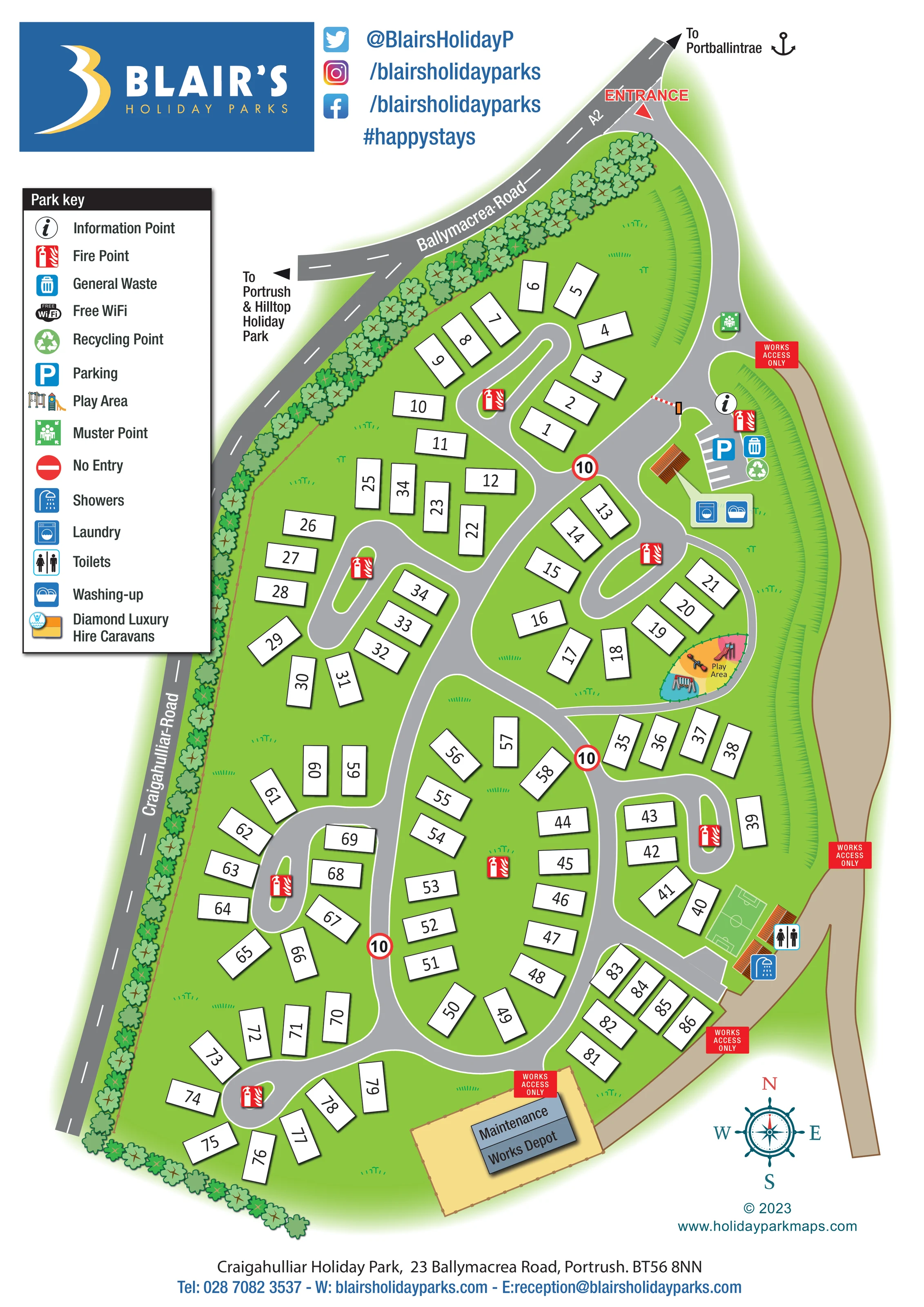
A continuous illustrated belt of leafy trees runs along the western roadside and curves around the southern boundary.
Bright green ground separates the caravan groups, while repeated grass strokes describe long curved banks along the eastern side.
An information symbol marks the arrival-side service area beside the entrance barrier and parking.
A small striped parking area with a blue P symbol sits beside the information point.
A colourful, enclosed-looking play area on the eastern side shows swings, a slide and other play equipment.
A green rectangular playing surface with white football-style markings is shown towards the lower-right side of the park.
A washing-machine symbol marks the small facility building below the arrival parking.
A washing-up symbol shares the facility building marked for laundry.
An information symbol marks the arrival-side service area beside the entrance barrier and parking.
A small striped parking area with a blue P symbol sits beside the information point.
A colourful, enclosed-looking play area on the eastern side shows swings, a slide and other play equipment.
A green rectangular playing surface with white football-style markings is shown towards the lower-right side of the park.
A washing-machine symbol marks the small facility building below the arrival parking.
A washing-up symbol shares the facility building marked for laundry.
Toilet and shower symbols identify facilities beside the games pitch near the eastern service route.
General waste and recycling symbols are grouped beside the arrival parking.
Repeated red fire-point symbols are distributed around the caravan groups, including several road-end islands.
A green muster-point symbol is placed beside the upper entrance approach.
Free Wi-Fi appears in the park key without a separately marked location on the plan.
A yellow-and-orange accommodation symbol is explained in the key, but its placement or allocation is not clearly identifiable in the illustrated accommodation.
The key includes a standard red no-entry symbol; a corresponding location is not clearly visible.
A red entrance label and arrow mark access from Ballymacrea Road. A striped barrier separates the approach from the internal road network.
A winding main road connects curved branches, loops and rounded turning heads. Circular signs bearing 10 are shown at several junctions.
A separate tan route follows the eastern edge, with repeated WORKS ACCESS ONLY labels and connections near the facilities and depot.
A labelled grey depot building occupies a fenced-looking tan compound at the southern end.
Named public roads frame the upper and western edges. Direction arrows point towards Portballintrae and towards Portrush and Hilltop Holiday Park; an A2 label also appears on the upper road.
A continuous illustrated belt of leafy trees runs along the western roadside and curves around the southern boundary.
Bright green ground separates the caravan groups, while repeated grass strokes describe long curved banks along the eastern side.
Operator information mentions an accessible toilet/shower. The map's toilet and shower symbols do not separately identify accessibility.
READING THE MAP
This map of Craigahulliar Holiday Park in Portrush presents a caravan park through a clear, overhead plan with a bright illustrated landscape. Set on Ballymacrea Road, the park is represented as an elongated site with a tree-lined western boundary, curving internal roads and small groups of numbered caravan plots. Around 85 accommodation footprints give the drawing a medium-sized scale without overwhelming the page.
The entrance is prominent at the top, where visitors can follow the approach towards an information point, parking and nearby service facilities. Further into the park, the map shows a children's play area, a marked games pitch, laundry, washing-up facilities, toilets and showers. A separate works-access route and maintenance depot are distinguished from the main visitor roads.
Blair's Holiday Parks branding, a substantial symbol key and a nautical compass rose frame the plan. The combination of simple accommodation shapes and more characterful trees, buildings and play equipment makes this a useful sample for caravan parks that need practical plot-finding alongside a recognisable, welcoming visual identity.
The single portrait artwork shows the park from above, with the entrance at its narrow northern end and the accommodation spreading into wider groups towards the bottom. Ballymacrea Road curves across the top, while Craigahulliar Road follows the western boundary. Direction arrows identify routes towards Portballintrae and towards Portrush and Hilltop Holiday Park.
Inside the site, a light grey road spine winds between clusters of white, numbered caravan rectangles. Short branches form loops and rounded turning heads, often enclosing slim green islands. The varied orientation of the accommodation follows these curves rather than a uniform grid. Red fire-point icons are distributed throughout the groups, and circular signs bearing 10 punctuate the main route.
The arrival area brings together a striped barrier, information point, parking, general waste and recycling symbols. A nearby small building is marked for laundry and washing-up. On the eastern side, a colourful playground shows individual pieces of equipment; further south, a football-marked games pitch sits beside toilet and shower facilities. A tan operational route runs along this edge, carrying repeated works-access-only notices and leading to the labelled maintenance depot at the bottom.
Landscape illustration gives the plan much of its character: closely spaced tree crowns line the western and southern edges, grass tufts fill open areas, and curved hatching suggests banks to the east. The large left-hand key explains the facility symbols, including Wi-Fi and a hire-caravan category without clearly marked positions. Branding and social details sit above the plan, with a compass and contact footer below. The accompanying enlargement repeats part of this same artwork to make the key and nearby plots easier to read.
KEEP EXPLORING
Chosen for shared landscapes, accommodation or facilities.
 Explore the map ↗
United Kingdom
Coastal park map with static-caravan rows, touring pitches, a camping field and two leisure clusters.
 Explore the map ↗
United Kingdom
A wooded Allerton park plan with colour-coded neighbourhoods, touring pitches and a central facilities hub.
 Explore the map ↗
United Kingdom
Illustrated coastal holiday-home plan with dense alphanumeric plot labels, orange-roofed amenities, a numbered facility key and beach-side context.
Features may come from the sample artwork, its key or published park information. Approximate numbers describe the drawing and may cover only part of a park. They are intended to help you compare map examples. Current facilities and booking information should be checked with the park.
TAKE A CLOSER LOOK
View the illustrated map in detail or choose a file to download. These are sample maps; contact the park for current visitor information.


LET’S MAP YOUR PARK
For a map quotation, find your park and draw a rough boundary around it. The area you select helps us work out the design time and price.
Draw your park for a quote ↗Or talk to our map designers
01751 473136