
River Gaunless
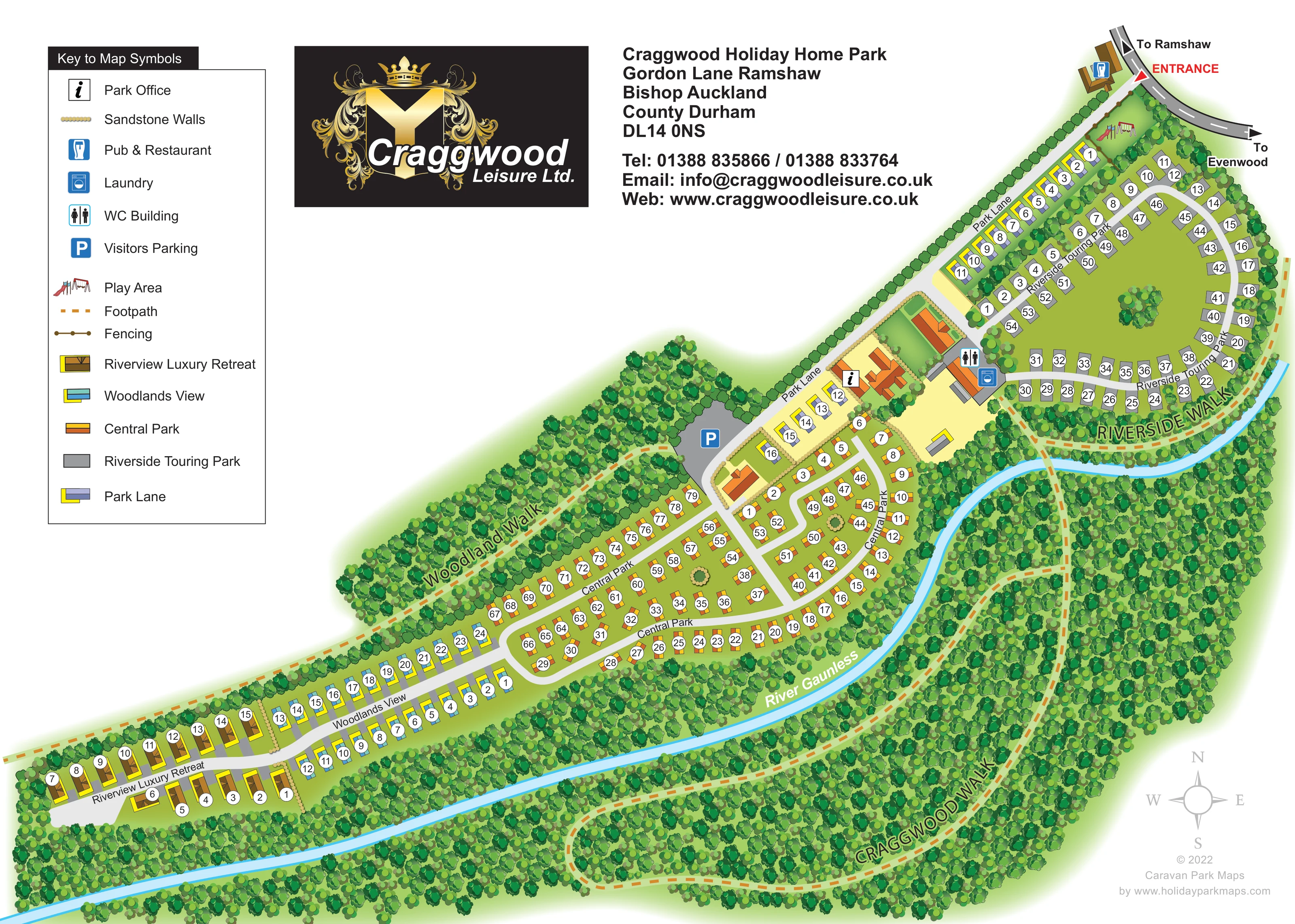
The named river curves along the southern edge of the accommodation and around the touring area, separating the developed park from extensive woodland.
ILLUSTRATED PARK MAP · P447
Gordon Lane, Ramshaw, Bishop Auckland, County Durham · United Kingdom
 Enlarge the map ↗
A SENSE OF THE PLACE
Craggwood Holiday Home Park is a family-run countryside retreat at Ramshaw near Bishop Auckland. Woodland and river views form part of its Teesdale setting.
The park focuses on privately owned holiday homes for time with family and friends. Published facilities include a family bar, shop, children's play, football space and laundry, with gated access and woodland areas around the grounds.
LOOK CLOSER
The named river curves along the southern edge of the accommodation and around the touring area, separating the developed park from extensive woodland.
Dense tree illustrations surround the accommodation, divide several sections and fill the large area beyond the river.
Beaded buff-coloured lines enclose parts of the central building grounds and divide some accommodation sections, matching the sandstone-wall key.
Brown post-and-line fencing is shown along the entrance-side boundary beside Park Lane.
An information symbol identifies the office within the orange-roofed building group beside Park Lane, close to visitor parking.
A blue glass symbol marks a building immediately beside the entrance road.
A grey parking area with a blue P symbol sits beside Park Lane, between woodland and the central building group.
Illustrated swings and a slide occupy a green area near the entrance, above the touring section.
An information symbol identifies the office within the orange-roofed building group beside Park Lane, close to visitor parking.
A blue glass symbol marks a building immediately beside the entrance road.
A grey parking area with a blue P symbol sits beside Park Lane, between woodland and the central building group.
Illustrated swings and a slide occupy a green area near the entrance, above the touring section.
A washing-machine symbol marks the service building at the junction between Park Lane, Central Park and Riverside Touring Park.
A toilet symbol appears at the same service-building cluster beside the touring area.
The named river curves along the southern edge of the accommodation and around the touring area, separating the developed park from extensive woodland.
Dense tree illustrations surround the accommodation, divide several sections and fill the large area beyond the river.
Named orange dashed footpaths trace the wooded edge above Central Park, the riverbank beside touring pitches and a substantial woodland loop beyond the river. A path connection is depicted across the river near the touring area.
The upper-right entrance is highlighted in red on the road signed towards Ramshaw and Evenwood.
The principal internal access runs diagonally from the entrance past a linear holiday-home section and the office buildings into the wider road network.
Beaded buff-coloured lines enclose parts of the central building grounds and divide some accommodation sections, matching the sandstone-wall key.
Brown post-and-line fencing is shown along the entrance-side boundary beside Park Lane.
READING THE MAP
This illustrated map of Craggwood Holiday Home Park brings together a riverside holiday-home layout, a touring area and extensive woodland walks on one page. Set at Ramshaw near Bishop Auckland in County Durham, the park is drawn as a long, tree-lined site following the River Gaunless. The blue river and dense green woodland give the plan its shape, while five named accommodation sections help visitors understand how the grounds are organised.
The artwork distinguishes Riverview Luxury Retreat, Woodlands View, Central Park, Park Lane and Riverside Touring Park through different accommodation colours and clear section labels. At the entrance end, it shows the pub and restaurant, play area and the route into the park; farther along Park Lane, symbols identify the office, visitor parking, laundry and WC building. Orange dashed paths extend the map beyond the accommodation to the Riverside, Woodland and Craggwood walks. A prominent black-and-gold Craggwood crest, a detailed key and a bold contact block complete a practical, branded visitor map.
The plan follows an elongated diagonal composition, with the entrance at the upper right and the narrower holiday-home sections extending towards the lower left. Direction arrows on the external road point towards Ramshaw and Evenwood. Park Lane leads into the grounds alongside a straight row of lavender-roofed homes, passing the entrance-side play area before reaching the central buildings and visitor parking.
Accommodation is organised into five clearly named sections. Brown-roofed homes mark Riverview Luxury Retreat at the western end, followed by the turquoise roofs of Woodlands View. Central Park occupies the broader middle of the site, where orange-and-yellow units line branching roads and curved loops. Riverside Touring Park forms a rounded section near the entrance, with grey pitch blocks arranged around a substantial grassy centre. White circular plot labels provide local identification without changing the overall colour hierarchy.
The office is marked beside an orange-roofed building group on Park Lane. A nearby service building carries laundry and WC symbols, while the pub and restaurant is identified beside the external entrance road. Sandstone-wall and fencing treatments add another layer of boundary information.
The River Gaunless runs along the lower edge of the developed park and bends around the touring area. Dense woodland fills much of the land beyond it. Orange dashed paths identify Woodland Walk, Riverside Walk and the larger Craggwood Walk loop, with a connection drawn across the river near the touring section. The upper-left key explains both practical symbols and accommodation colours; the crest and contact details occupy the remaining white space above the site. A subtle compass and designer credit finish the lower-right corner.
KEEP EXPLORING
Chosen for shared landscapes, accommodation or facilities.
 Explore the map ↗
United Kingdom
Woodland holiday homes, named camping fields and farm buildings on a colour-coded Nether Wasdale park map.
 Explore the map ↗
United Kingdom
Illustrated caravan park plan with woodland and riverside walks, fishing pools and wildlife panels.
 Explore the map ↗
United Kingdom
Woodland caravan park map with named pitch areas, walking routes and an enlarged amenities block.
Features may come from the sample artwork, its key or published park information. Approximate numbers describe the drawing and may cover only part of a park. They are intended to help you compare map examples. Current facilities and booking information should be checked with the park.
TAKE A CLOSER LOOK
View the illustrated map in detail or choose a file to download. These are sample maps; contact the park for current visitor information.


LET’S MAP YOUR PARK
For a map quotation, find your park and draw a rough boundary around it. The area you select helps us work out the design time and price.
Draw your park for a quote ↗Or talk to our map designers
01751 473136
 craggwoodtouring.png
 riversideluxury.png
 woodlandsview.png
 craggwoodtouring_large.png
 riversideluxury_large.png
 woodlandsview_large.png