
Tree-lined boundaries and landscaped plots
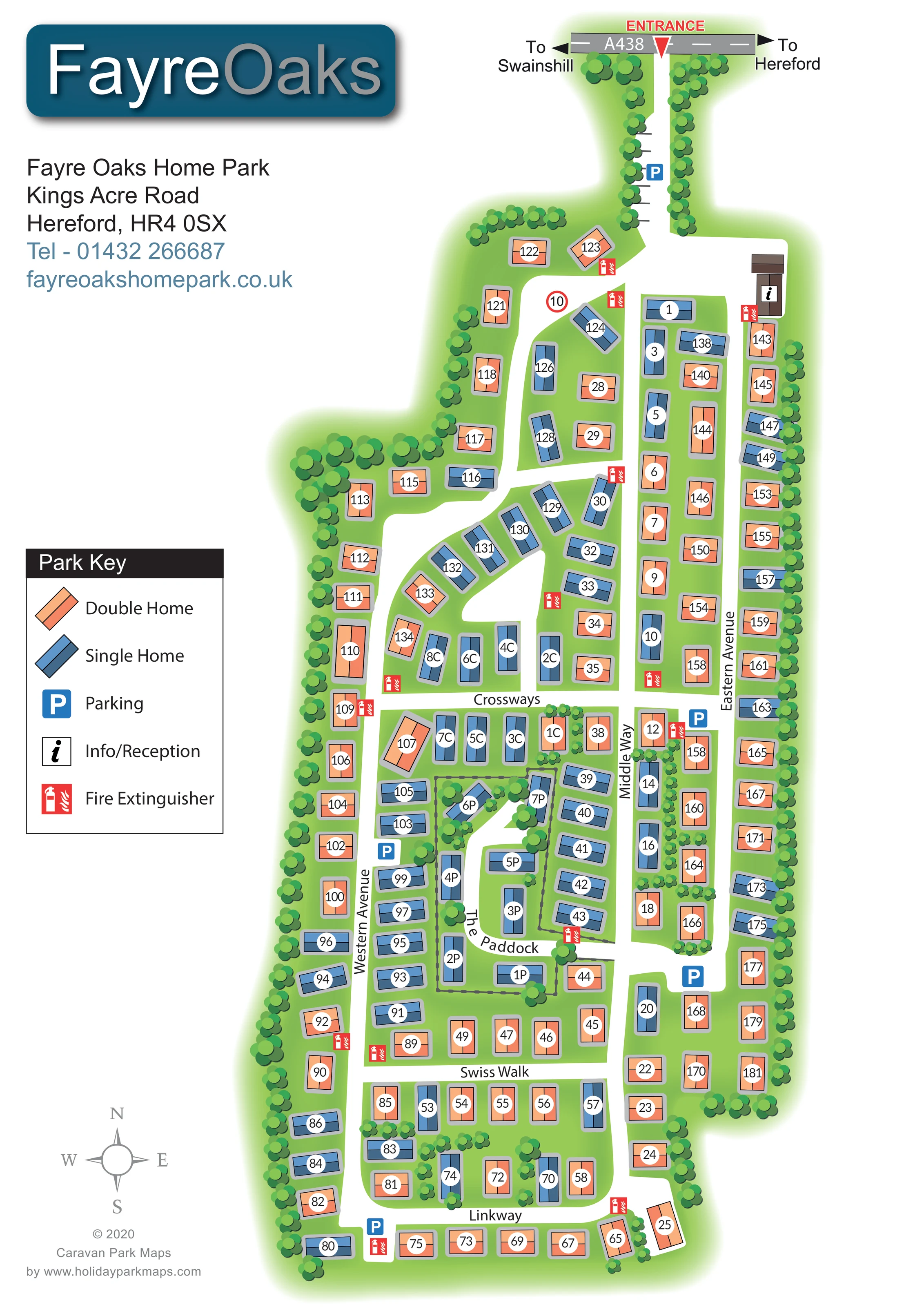
Dense rows of stylised trees define much of the perimeter and entrance, with smaller groups separating homes and enclosing parts of the central layout.
ILLUSTRATED PARK MAP · P457
Fayre Oaks Home Park, Kings Acre Road, Hereford · United Kingdom
 Enlarge the map ↗
A SENSE OF THE PLACE
Fayre Oaks Home Park is based at Kings Acre Road, Hereford. The site is located on the A438 leaving Hereford, with a nearby bus stop and convenience store. The park has a full residential licence permitting year-round occupation.
New homes are described as having landscaped plots and block-paved parking.
LOOK CLOSER
Dense rows of stylised trees define much of the perimeter and entrance, with smaller groups separating homes and enclosing parts of the central layout.
A compact central residential grouping is wrapped by a curving white route, planting and a grey dotted boundary treatment. It is not depicted as an open camping field.
A brown-roofed building carrying the information symbol stands on the eastern side of the arrival area, just inside the park.
Blue parking symbols identify several locations along the entrance drive and within the residential road network. Short bay markings are drawn beside the entrance approach.
Repeated red fire extinguisher symbols appear beside residential roads, junctions and the reception area.
The entrance is prominently marked at the top of the plan, with a red pointer leading from the A438 into the tree-lined approach.
Opposing arrows on the A438 indicate Swainshill to the left and Hereford to the right.
Western Avenue, Middle Way and Eastern Avenue provide the principal longitudinal routes. Crossways, Swiss Walk and Linkway connect the residential rows, while The Paddock names the central landscaped group.
A brown-roofed building carrying the information symbol stands on the eastern side of the arrival area, just inside the park.
Blue parking symbols identify several locations along the entrance drive and within the residential road network. Short bay markings are drawn beside the entrance approach.
Repeated red fire extinguisher symbols appear beside residential roads, junctions and the reception area.
The entrance is prominently marked at the top of the plan, with a red pointer leading from the A438 into the tree-lined approach.
Opposing arrows on the A438 indicate Swainshill to the left and Hereford to the right.
Western Avenue, Middle Way and Eastern Avenue provide the principal longitudinal routes. Crossways, Swiss Walk and Linkway connect the residential rows, while The Paddock names the central landscaped group.
Dense rows of stylised trees define much of the perimeter and entrance, with smaller groups separating homes and enclosing parts of the central layout.
A compact central residential grouping is wrapped by a curving white route, planting and a grey dotted boundary treatment. It is not depicted as an open camping field.
A red-bordered circular sign containing '10' is drawn near the first internal bend after the entrance.
Operator information describes a full residential licence permitting year-round occupation; this is contextual information rather than a mapped facility.
READING THE MAP
This map of Fayre Oaks Home Park in Hereford presents a residential community through a clear, colour-coded site plan. The elongated park stretches south from its entrance on the A438, with a tree-lined approach leading into a network of named avenues and connecting streets. Blue single homes and peach-and-coral double homes are distributed throughout the plan, each carrying a prominent white home-number badge.
The artwork combines practical navigation with a recognisable impression of the landscaped setting. Rows of trees frame the boundaries, smaller planting groups separate homes, and the central area called The Paddock adds a distinct feature within the residential layout. Reception, parking locations and fire extinguisher points are marked using symbols explained in the Park Key.
A generous left-hand column holds the FayreOaks branding, address, contact details, legend and compass, leaving the main plan uninterrupted on the right. This sample is particularly relevant to residential park clients who need to show different home types, a substantial address network and everyday arrival information without turning the map into a technical drawing.
The single portrait artwork shows the complete residential layout, with north at the top and the A438 forming a short horizontal road strip above the entrance. Arrows indicate the directions towards Swainshill and Hereford, while a red entrance label and pointer identify the turn into the park. The approach is bordered by closely spaced tree symbols and includes parking markings before opening into the main residential area. A brown reception building with an information icon stands on the right of this arrival space.
Within the park, broad white roads separate green plots. Western Avenue follows the left-hand side, Eastern Avenue runs down the right, and Middle Way provides a central route. Crossways, Swiss Walk and Linkway connect the rows. Near the middle, The Paddock forms a smaller landscaped group with a curving route and dotted grey boundary treatment. Homes are aligned along streets or angled around bends, giving the plan more variation than a uniform grid.
The Park Key distinguishes blue single homes from peach-and-coral double homes. Both use outlined, two-tone roof shapes on grey surrounds, with white circular labels placed over the buildings. Parking symbols occur at several points in the road network, and red fire extinguisher markers are distributed around the residential areas. A circular 10 sign is also illustrated near the arrival bend.
The page reserves its left side for the large FayreOaks brand panel, address and contact information, boxed key, compass and designer credit. The accompanying detail view enlarges this same key and part of Western Avenue; it is not a separate map or an additional accommodation area.
KEEP EXPLORING
Chosen for shared landscapes, accommodation or facilities.
 Explore the map ↗
United Kingdom
Illustrated Sanday aire map with a seasonal maze, café barn and motorhome service area.
 Explore the map ↗
United Kingdom
Illustrated coastal campsite plan with named fields, electric pitch colours, beach routes and the Afon Hen.
 Explore the map ↗
United Kingdom
A woodland touring-park map with colour-coded pitches, a stream and footprint-marked walks.
Features may come from the sample artwork, its key or published park information. Approximate numbers describe the drawing and may cover only part of a park. They are intended to help you compare map examples. Current facilities and booking information should be checked with the park.
TAKE A CLOSER LOOK
View the illustrated map in detail or choose a file to download. These are sample maps; contact the park for current visitor information.


LET’S MAP YOUR PARK
For a map quotation, find your park and draw a rough boundary around it. The area you select helps us work out the design time and price.
Draw your park for a quote ↗Or talk to our map designers
01751 473136