
Tree and shrub boundaries
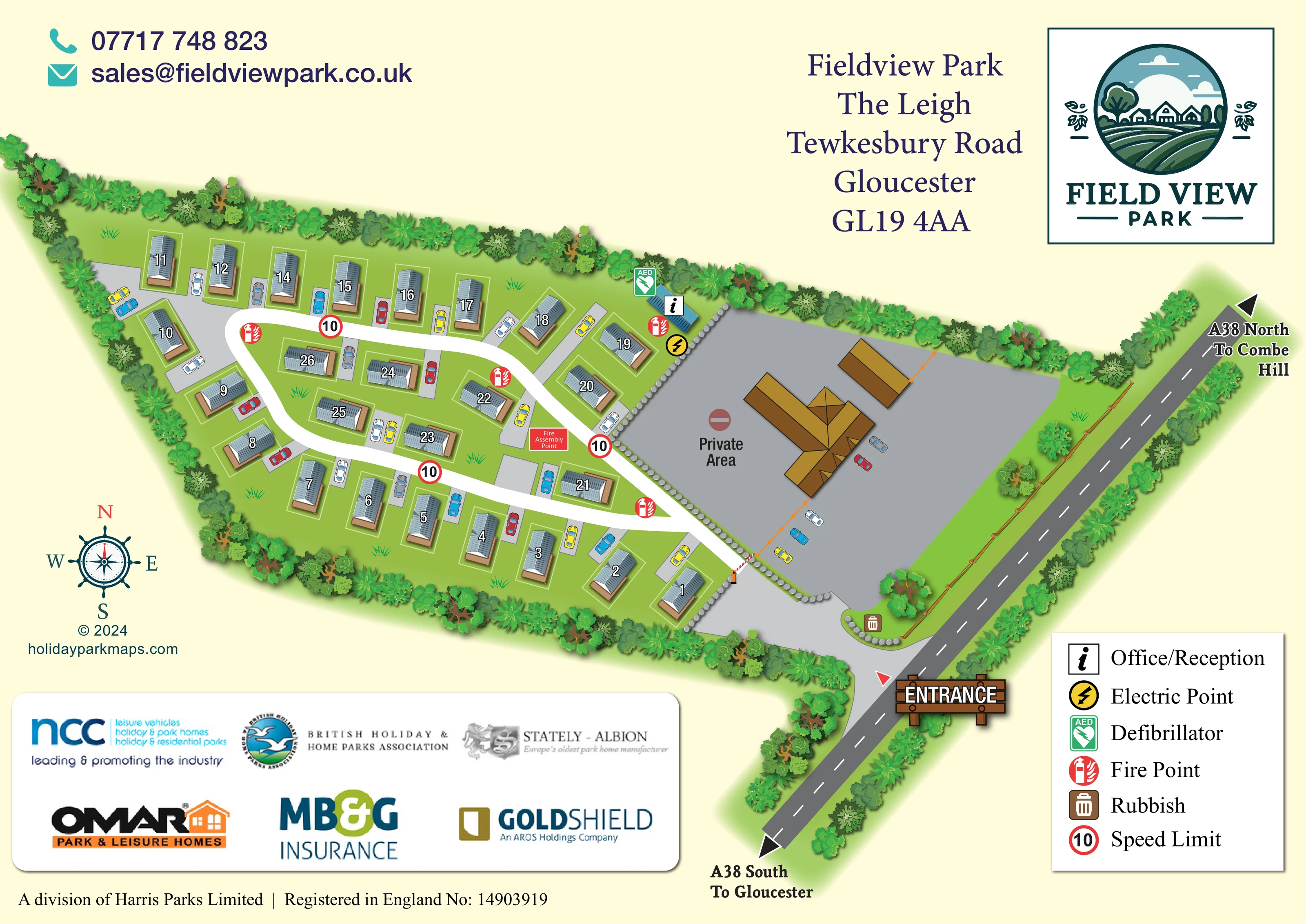
Dense illustrated trees and shrubs frame the residential plots and line the A38, with open green plot space inside the development.
ILLUSTRATED PARK MAP · P119
The Leigh, Gloucester · United Kingdom
 Enlarge the map ↗
A SENSE OF THE PLACE
Fieldview Park is a private, gated park-home development at The Leigh in Gloucestershire. Individual plots have paved drives, with the development positioned beside the A38 between Gloucester and Tewkesbury.
Its focus is park-home living and homes for sale. The map illustrates the residential layout and access routes, providing a different example of site mapping from the touring and holiday accommodation elsewhere in the gallery.
LOOK CLOSER
Dense illustrated trees and shrubs frame the residential plots and line the A38, with open green plot space inside the development.
Individual grey stones distinguish the private-area edge and entrance island; a brown fence follows part of the A38 frontage.
An information symbol marks a small blue-roofed building at the upper edge of the residential area, beside the private-area boundary.
A yellow lightning symbol beside the office identifies an electric point; its precise function is not specified.
A green AED symbol is positioned beside the office/reception.
Red fire-point symbols appear at several locations around the internal road and beside the office.
A red labelled assembly-point sign appears on the green space near the junction of the loop and entrance approach.
A brown bin symbol marks a rubbish point on the landscaped island beside the entrance approach.
An information symbol marks a small blue-roofed building at the upper edge of the residential area, beside the private-area boundary.
A yellow lightning symbol beside the office identifies an electric point; its precise function is not specified.
A green AED symbol is positioned beside the office/reception.
Red fire-point symbols appear at several locations around the internal road and beside the office.
A red labelled assembly-point sign appears on the green space near the junction of the loop and entrance approach.
A brown bin symbol marks a rubbish point on the landscaped island beside the entrance approach.
Grey driveways connect the home plots to the internal road, with coloured car illustrations showing their parking function.
A prominent timber-style entrance sign identifies the A38 junction, while a red-and-white barrier marks access to the residential road.
A white loop road serves perimeter homes and a smaller central group, joining the entrance approach beside the private area.
Repeated red-ringed signs displaying 10 are placed along the internal road and explained by the legend.
The adjoining road is labelled A38 North to Combe Hill and A38 South to Gloucester, with arrowheads at either end.
A large grey area containing ochre-roofed buildings is labelled Private Area and marked with a no-entry symbol. Its buildings are not identified as resident facilities.
Dense illustrated trees and shrubs frame the residential plots and line the A38, with open green plot space inside the development.
Individual grey stones distinguish the private-area edge and entrance island; a brown fence follows part of the A38 frontage.
READING THE MAP
This illustrated map of Fieldview Park presents a compact residential park-home development at The Leigh in Gloucestershire. Beside the A38 between Gloucester and Tewkesbury, the site is shown as a planted enclave of detached homes, each with its own outlined plot and paved drive. A white internal road loops through the development, making the relationship between the outer row of homes and the smaller central group easy to follow.
The design gives particular attention to arrival and orientation. A timber-style entrance sign marks the approach from the A38, a barrier identifies the residential access, and directional labels point towards Gloucester and Combe Hill. The office, electric point, defibrillator, fire points and rubbish location use a compact set of contrasting symbols.
Blue-grey roofs, coloured cars and a varied border of trees bring detail to the plan without obscuring the home numbers. A clearly labelled private compound remains visually separate from the residential plots. The finished page combines practical site navigation with prominent park branding, address information and sales contacts, making this a useful example of mapping for a residential development rather than a holiday park.
The single landscape-format artwork places the residential layout across the centre and left of the page, with the A38 running diagonally along the right. Roughly 25 park homes are depicted within a continuous planted boundary. Most occupy perimeter plots, while a smaller group sits inside the white loop road. Each home has a shaded blue-grey roof, a tan base and a bold outlined number. Grey drives and small car illustrations distinguish parking space from the green plots.
The arrival sequence begins at the large entrance sign beside the A38. A broad grey approach curves past a landscaped island carrying the rubbish symbol, then reaches a red-and-white barrier at the residential road. The road continues around the central homes and returns towards the approach. Repeated signs displaying 10 and red fire-point symbols punctuate this route. A labelled fire assembly point sits near the junction on the residential side.
At the upper boundary, a small blue-roofed office is accompanied by information, AED, electric-point and fire-point symbols. Immediately alongside it, stone edging separates the homes from a large grey compound. This space contains ochre-roofed buildings and is explicitly labelled Private Area, reinforced by a no-entry symbol. A brown fence and planted verge provide further definition along the main-road frontage.
The cream page leaves generous space for contact details, the park address and the boxed Field View Park logo above the plan. Below, a compass rose and designer credit sit beside a rounded panel of industry and commercial logos. The six-entry legend occupies the bottom-right corner. Tree canopies, grass tufts and soft shadows add texture, while the restrained route colours preserve a clear hierarchy between the main road, internal circulation and individual drives.
KEEP EXPLORING
Chosen for shared landscapes, accommodation or facilities.
 Explore the map ↗
United Kingdom
Illustrated Sanday aire map with a seasonal maze, café barn and motorhome service area.
 Explore the map ↗
United Kingdom
Illustrated coastal campsite plan with named fields, electric pitch colours, beach routes and the Afon Hen.
 Explore the map ↗
United Kingdom
A woodland touring-park map with colour-coded pitches, a stream and footprint-marked walks.
Features may come from the sample artwork, its key or published park information. Approximate numbers describe the drawing and may cover only part of a park. They are intended to help you compare map examples. Current facilities and booking information should be checked with the park.
LET’S MAP YOUR PARK
For a map quotation, find your park and draw a rough boundary around it. The area you select helps us work out the design time and price.
Draw your park for a quote ↗Or talk to our map designers
01751 473136