
Waterside, The Pit and The Pool
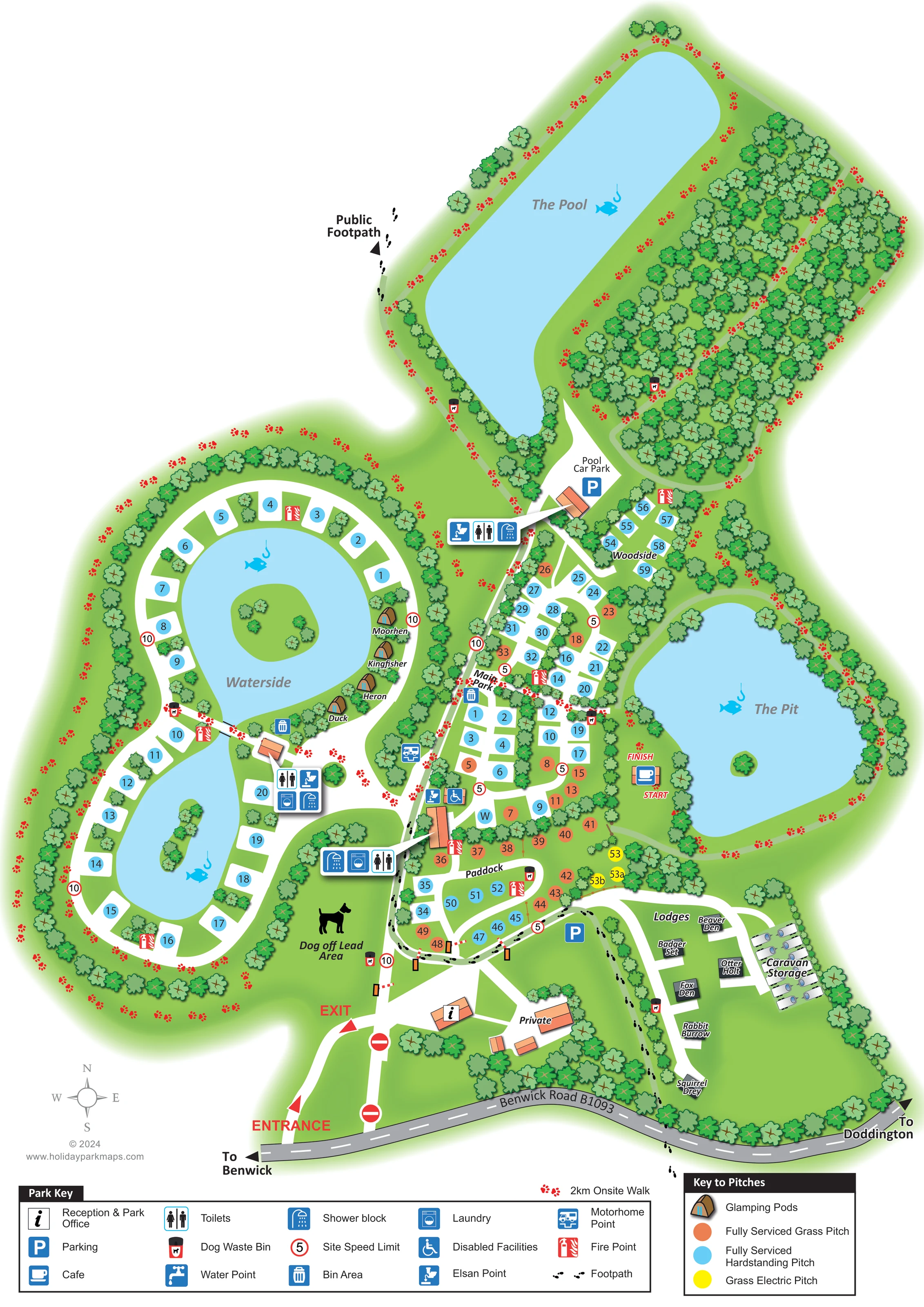
Three prominent blue waters shape the plan: a two-lobed Waterside lake with islands, the rounded eastern Pit and the elongated northern Pool. Fish-and-hook motifs reinforce the fishing setting.
ILLUSTRATED PARK MAP · P118
Benwick Road, Doddington, Cambridgeshire · United Kingdom
 Enlarge the map ↗
A SENSE OF THE PLACE
Fields End Water is a holiday and fishing destination at Doddington in Cambridgeshire. Its accommodation includes touring, glamping and lodges, giving visitors several ways to stay.
The park provides separate contact arrangements for lodge bookings and touring, glamping and fishing enquiries. The map gives an overview of the accommodation and waterside areas, supporting visitors planning a stay in the surrounding Fenland countryside.
LOOK CLOSER
Three prominent blue waters shape the plan: a two-lobed Waterside lake with islands, the rounded eastern Pit and the elongated northern Pool. Fish-and-hook motifs reinforce the fishing setting.
Dense woodland fills much of the land beside The Pool, with continuous tree belts around lakes and accommodation boundaries.
An information symbol identifies the reception building just inside the road entrance.
A cup symbol marks a café beside The Pit, next to the walk's start and finish labels.
Parking is marked near the lodge approach and at the separately labelled Pool Car Park.
Grouped facility symbols identify toilets, shower blocks and laundry around the central touring and Waterside areas and near the Pool approach.
A wheelchair symbol marks facilities beside the central service building; the legend calls these Disabled Facilities.
Elsan symbols appear beside service buildings, with a motorhome point marked along the main north–south route.
An information symbol identifies the reception building just inside the road entrance.
A cup symbol marks a café beside The Pit, next to the walk's start and finish labels.
Parking is marked near the lodge approach and at the separately labelled Pool Car Park.
Grouped facility symbols identify toilets, shower blocks and laundry around the central touring and Waterside areas and near the Pool approach.
A wheelchair symbol marks facilities beside the central service building; the legend calls these Disabled Facilities.
Elsan symbols appear beside service buildings, with a motorhome point marked along the main north–south route.
A blue W marker appears at the southern end of Main Park; the park key includes a water-point symbol.
General waste points occur near accommodation and service areas, while dog waste bins are distributed along walks and park edges.
Red fire-point symbols are distributed across the touring areas and near the central service building.
A labelled group of illustrated caravans occupies a separate strip beside the lodges.
A green enclosure between Waterside and the entrance is labelled Dog off Lead Area and illustrated with a black dog silhouette.
Three prominent blue waters shape the plan: a two-lobed Waterside lake with islands, the rounded eastern Pit and the elongated northern Pool. Fish-and-hook motifs reinforce the fishing setting.
Dense woodland fills much of the land beside The Pool, with continuous tree belts around lakes and accommodation boundaries.
Red paw prints trace the labelled 2km onsite walk through the lakeside and wooded grounds; start and finish labels sit beside the café at The Pit.
Black footprint symbols distinguish a public footpath from the red-paw onsite walk, including a labelled connection west of The Pool.
Benwick Road B1093 runs across the bottom of the map, with directions to Benwick and Doddington and separately marked entrance and exit lanes.
Red-ringed numeric signs appear along internal routes, with different values shown in different areas.
Buildings beside reception and the lodge approach are labelled Private, separating them from visitor facilities.
READING THE MAP
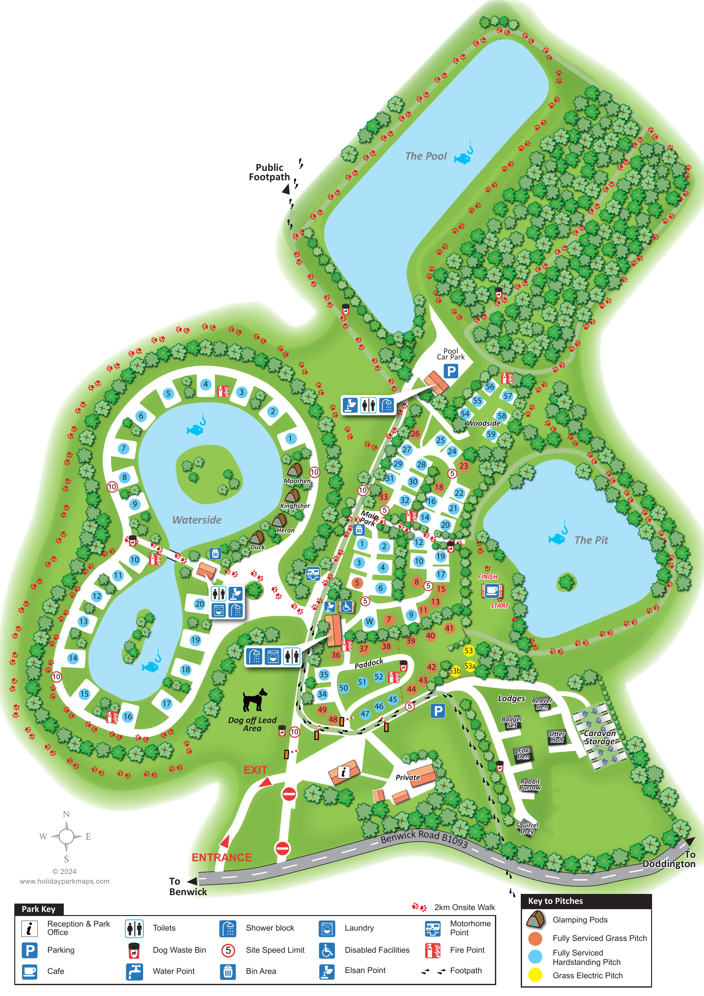
This illustrated map of Fields End Water brings together touring accommodation, glamping pods, lodges and fishing waters at Doddington in Cambridgeshire. Its distinctive shape follows the park itself: accommodation and arrival facilities occupy the lower part of the page, while The Pool and a substantial wooded area extend towards the top. Three blue waters give visitors an immediate sense of the setting before they begin looking for a particular pitch or facility.
The map shows touring areas named Waterside, Main Park, Paddock and Woodside, with coloured numbered markers distinguishing pitch types. Wildlife-themed names identify the lakeside pods and the separate lodge area. Reception, washrooms, parking and touring service points are picked out with pictograms, while a café sits beside The Pit.
Walking is an important part of the design. Red paw prints trace a labelled 2km onsite walk around the grounds, and black footprints identify footpaths. Together with the dog off-lead area, lake islands and dense tree belts, these details make the map useful both for finding accommodation and for exploring the park.
The plan begins at Benwick Road B1093, drawn along the bottom edge with arrows towards Benwick and Doddington. Separate entrance and exit lanes lead into the reception area. From here, white internal roads branch towards the touring sections, lodge enclosure and northern waters, making the arrival sequence easy to follow without overwhelming the landscape illustration.
On the left, Waterside pitches curve around a two-lobed lake containing small planted islands. Four illustrated pods sit along its eastern shore, labelled Duck, Heron, Kingfisher and Moorhen. Main Park occupies the central strip between Waterside and The Pit, with Paddock immediately below and the smaller Woodside group above. The separate lodge lane lies near the road frontage, alongside a labelled caravan-storage area. Coloured circles distinguish fully serviced hardstanding, fully serviced grass and grass electric pitches.
Grouped symbols identify toilets, showers and laundry, with additional markers for disabled facilities, Elsan disposal, a motorhome point, waste and fire points. Parking is shown near the lodges and at Pool Car Park. The café beside The Pit also provides a clear visual anchor for the onsite walk's start and finish labels.
The upper portion extends around The Pool and a dense block of woodland. Red paw prints carry the walking route through this landscape and around the southern lakes, contrasting with the black footprint convention used for footpaths. A dog off-lead area is labelled near the entrance. At the foot of the page, separate facility and pitch keys explain the visual language. The accompanying detail views enlarge these same keys rather than introducing additional map sections.
KEEP EXPLORING
Chosen for shared landscapes, accommodation or facilities.
 Explore the map ↗
United Kingdom
Woodland park map with mixed pitches, bell tents, lodges and a fishing lake.
 Explore the map ↗
United Kingdom
Colour-coded accommodation, lakeside facilities and woodland routes at Burton Constable Holiday Park & Arboretum.
 Explore the map ↗
United Kingdom
Illustrated farm campsite map with touring pitches, pods, camping fields and a riverside dog-walk route.
Features may come from the sample artwork, its key or published park information. Approximate numbers describe the drawing and may cover only part of a park. They are intended to help you compare map examples. Current facilities and booking information should be checked with the park.
TAKE A CLOSER LOOK
View the illustrated map in detail or choose a file to download. These are sample maps; contact the park for current visitor information.


LET’S MAP YOUR PARK
For a map quotation, find your park and draw a rough boundary around it. The area you select helps us work out the design time and price.
Draw your park for a quote ↗Or talk to our map designers
01751 473136
 fieldsendwater_large.png